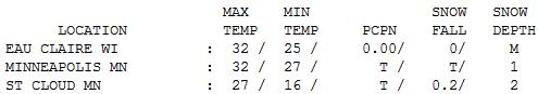
32 F. high in the Twin Cities Wednesday.
26 F. average high for December 19.
38 F. high on December 19, 2011 at KMSP.
8 hours and 46 minutes of daylight today
8 hours and 46 minutes of daylight in the cities on December 31.
December 25: We actually pick up one extra minute of daylight beginning on Christmas Day.

On Edge
If only we could schedule heavy snows for
weekends, falling only on lawns, fields and trails. My next invention?
Although tinkering with weather, however futile, would come with an army
of lawyers. Pleasing all the people all the time? Good luck.
No travel is recommended over Iowa this morning,
where whiteout conditions are likely. The metro may pick up an inch or
two of fluff. If your travels take you east on I-94 or south on I-35,
travel will get progressively worse. Pack a winter survival kit, and
don't hesitate to pull into a restaurant or rest stop if conditions get
really bad.
Often the biggest concern isn't the amount of
snow, but visibility. If you can't see the road the odds of getting into
trouble multiply.
A very white Christmas is likely from Des Moines to Madison & Green Bay: a foot of snow possible with 2-3 foot drifts.
Whatever snow is in your yard (today) will still
be there Christmas morning. Chilly, dry weather spills over into
Christmas Eve. No weather drama close to home.
Shocker: next week's storm will probably track
south/east of Minnesota. The good news? We may avoid a subzero New
Year's Eve; the latest model runs don't look nearly as cold. Whew..
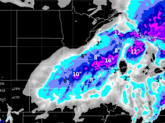
Right On The Edge. WSI's 12 km. RPM model prints out
some 1-3" amounts for the southern and eastern suburbs, closer to 6"
for Rochester, maybe 8" at La Crosse. The heaviest snow bands are
forecast to set up from the Quad Cities to the Wisconsin Dells and
Madison, to the suburbs of Milwaukee, where some 10-14" amounts are
possible. Winds gusting past 35 mph will carve out some 2-3 foot drifts
from Iowa into southern Wisconsin. Great fun.
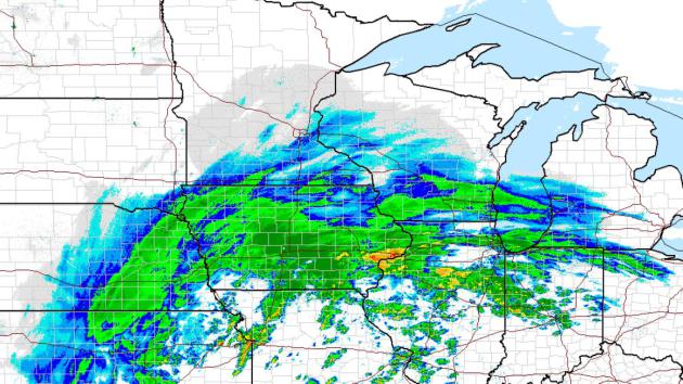 Anatomy of a Blizzard
.
The heaviest snow bands will set up just south and east of MSP, but I
could see some 2-3" amounts from Burnsville and Eagan to Woodbury,
Maplewood and Stillwater, enough to slow down the morning commute.
Meanwhile the far western and northern suburbs may only see a coating to
an inch or so, with virtually no snow from Monticello to St. Cloud. The
latest NOAA high-res radar image is
here.
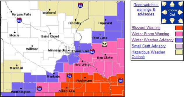
Blizzard Warnings: Des Moines to Rochester to Madison.
NOAA
has issued Blizzard Warnings extending into south central and
southeastern Minnesota; a potential for 6-10" snow, whipped around by
30-40 mph winds, producing white-out conditions thru early afternoon
Thursday. Details from the local Twin Cities NWS:
...POWERFUL WINTER STORM WILL IMPACT SOUTHEAST MINNESOTA AND WEST
CENTRAL WISCONSIN TONIGHT AND THURSDAY...

.A MAJOR WINTER STORM WILL SPREAD SNOW ACROSS SOUTHERN MINNESOTA
AND WEST CENTRAL WISCONSIN BEGINNING TONIGHT...AND LASTING THROUGH
THURSDAY. SNOWFALL TOTALS WILL RANGE FROM 5 TO 9 INCHES ALONG A
LINE FROM ALBERT LEA...TO RED WING MINNESOTA...AND UP THROUGH
EAU CLAIRE WISCONSIN...WITH LESSER AMOUNTS NORTH AND WEST OF THIS
LINE. STRONG NORTHWEST WINDS OF 25 MPH...WITH GUSTS 30 TO 40 MPH
WILL ACCOMPANY THE SNOW AND CAUSE SIGNIFICANT BLOWING AND DRIFTING
ALONG I-90 IN MINNESOTA...AND I-94 IN WISCONSIN. TRAVEL WILL
BECOME EXTREMELY DANGEROUS AND IS NOT RECOMMENDED.


...BLIZZARD WARNING REMAINS IN EFFECT UNTIL 6 PM CST THURSDAY...

* TIMING...LIGHT SNOW IS BEGINNING...AND WILL INCREASE IN
  INTENSITY LATER TONIGHT. PERIODS OF MODERATE TO HEAVY SNOW ARE
  EXPECTED...WITH STRONG WINDS DEVELOPING EARLY THURSDAY MORNING.

* WINDS/VISIBILITY...STRONG NORTHWEST WINDS OF 30 MPH WITH GUSTS
  NEAR 40 MPH ARE EXPECTED THURSDAY. THIS WILL CAUSE NEAR ZERO
  VISIBILITIES AT TIMES...ESPECIALLY IN OPEN AREAS.

* SNOW ACCUMULATIONS...5 TO 9 INCHES OF SNOW ARE EXPECTED BY
  THURSDAY AFTERNOON.

PRECAUTIONARY/PREPAREDNESS ACTIONS...

A BLIZZARD WARNING MEANS SEVERE WINTER WEATHER CONDITIONS ARE
EXPECTED. FALLING AND BLOWING SNOW WITH STRONG WINDS AND POOR
VISIBILITIES ARE LIKELY. THIS WILL LEAD TO WHITEOUT CONDITIONS...
MAKING TRAVEL EXTREMELY DANGEROUS. DO NOT TRAVEL. IF YOU MUST
TRAVEL...HAVE A WINTER SURVIVAL KIT WITH YOU. IF YOU GET
STRANDED...STAY WITH YOUR VEHICLE.
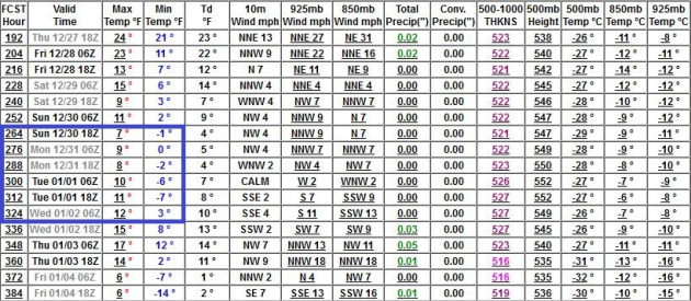
Extended Outlook: Cold! After being brushed by a
blizzard today the forecast calls for dry and cold, ECMWF model data
shows temperatures 10 degrees or more below average from Christmas Day
thru the end of next week. No big storms in sight next week, so getting
home after Christmas shouldn't be a major hassle. In theory.
A Numbing New Year The latest GFS run doesn't look
quite as cold as previous model runs, but it still looks like highs hold
in the teens New Year's Eve and New Year's Day, with nighttime lows
dipping below zero in the suburbs. Not exactly record-territory, but Old
Man Winter will get your attention by the end of 2012.
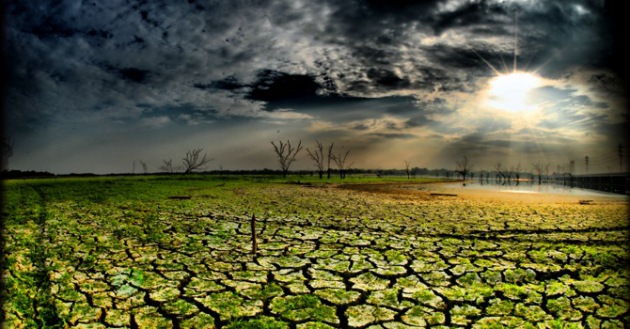
Drought Update. Here is an excerpt of an e-mail I received from Minnesota State Climatologist Greg Spoden on Monday: "
Regarding
our present drought in historical context...the last time that this
much of Minnesota's landscape was categorized as undergoing Extreme
Drought was during the autumn of 2006 through early spring 2007. In that
interval, roughly 40 percent of the state was in the Extreme Drought
category. That drought impacted northern Minnesota. The Twin Cities,
and most of the state's primary agricultural regions, were very dry
during the fall and winter, but not to the same extent as Minnesota's
forested areas."
"Without abundant 2013 spring rains, the intensity and
spatial extent of Minnesota's drought will become similar to, or
surpass, the drought conditions of the late 1980s."
* more on the
Drought of 1988 from
Wikipedia: "
The
Drought of 1988 became the worst drought since the Dust Bowl 50
years before in the United States; 2008 estimates put damages from the
drought somewhere between $80 billion and almost $120 billion in
damage (2008 USD). The state of Minnesota alone saw approximately 1.2 billion dollars in crop losses. The Drought of 1988 was so devastating that in later years it was compared against Hurricane Andrew in 1992 and against Hurricane Katrina being the
costliest of the three events. The Drought of 1988 qualifies being
the costliest natural disaster in the history of the United States. In
Canada, drought-related losses added up to about 1.8 billion [1988]
dollars."
Warning About Storm Surges Are Essential: Editorial. Here is part of an Op-Ed at
nola.com in New Orleans: "...
Three years after it dropped surge from the numerical categories used for hurricanes, the National Hurricane Center is inching closer to a separate warning
for floodwaters as part of a storm system. It is urgently needed.
Center officials say that the full warning system won't be ready until
2015, but they should look for any way possible to speed up that time
line. In the meantime, a color-coded map that indicates how much
water is expected in different areas along the coast needs to be ready
for use during the 2013 hurricane season. But Hurricane Center
officials are not committing to that. They say the map may be ready
next year or in 2014. Another hurricane season is really too long for
vulnerable communities to wait. The maps ought to be available for
the 2013 season, and Congress should give the Hurricane Center the
resources to make that possible..."
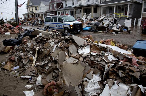
Photo credit above: "
A New York Police Department van
drives along a street soaked with rain and covered with debris in a
Rockaway neighborhood of the borough of Queens as a nor'easter
aggravates already bad conditions in the wake of Superstorm Sandy."
(Photo by AP Photo/Craig Ruttle)
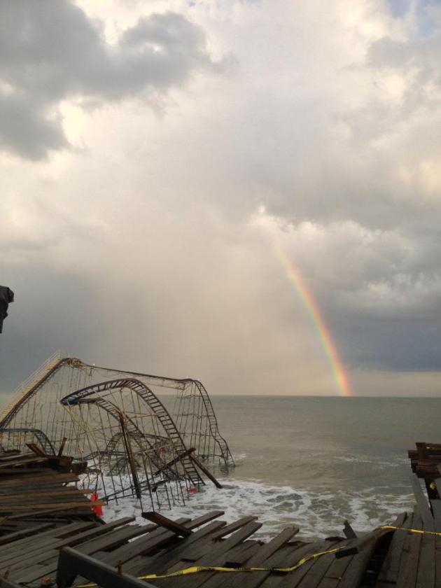
A Surreal Sight. A rainbow formed over the Jet Star
roller coaster, or what's left of it, on Tuesday in Seaside Heights,
New Jersey. The area was hit very hard by Sandy in late October. Photo
from Casino Pier's Facebook page.
Severe Weather And The Grid. All I want for
Christmas is an electrical generator. America's power grid is
increasingly vulnerable to a new generation of super-sized storms,
hurricanes, tornadoes and derechos, as described in this article from
IEEE Spectrum: "
Uncannily,
in a report on "Extreme Weather and Grid Disruptions" that was
issued in May and updated on Aug. 30, Evan Mills of Lawrence Berkeley
Laboratory cited risk manager estimates that a severe Northeast U.S hurricane could result in total costs of $76.4 billion,
uninsured costs of $45.1 billion, and 85 fatalities. Those
projections are right in line with current estimates of the total
costs and fatalities from the perfect storm dubbed "frankenstorm," the
combined hurricane and Nor'easter that devastated cities and
communities in the U.S.Northeast at the end of October. According to
ten-year-old estimates from the Electric Power Research Institute,
displayed by Evans in his report, annual costs to the U.S. power grid
from severe weather average $104-164 billion..."
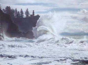
These Freak Waves Can Attack Anytime Without Warning. Just when I was about ready to head back into the water, along comes this story from
Business Insider - here's the introduction: "
A
freak wave killed seven people in Chicago on a sunny day on the shore
of Lake Michigan nearly 60 years ago. At the time, no one knew what
set off the monster wave. Researchers now know the wave was a
pressure-driven tsunami, stirred up by storms passing earlier in the
day, said Chin Wu, an engineering professor at the University of
Wisconsin, Madison, at last week's annual meeting of the American
Geophysical Union. Called meteotsunamis, the weather-related waves
strike frequently in the Great Lakes and along the U.S. coastline.
The 10-foot-high (3 meter) wall of water that hit Chicago was one of
two recorded in Lake Michigan in June 1954..."
Deadly Caribbean Tsunami Overlooked. Now I really don't want to go in the water. Remind me to stick to Minnesota's cool (quiet) lakes.
Yahoo News has the story; here's a clip: "
Deadly tsunamis threaten Puerto Rico, the Virgin Islands and the rest of the Caribbean and are an overlooked hazard in the region, geologists reported at the annual meeting of the American Geophysical Union here last week. The Caribbean's beautiful tropical islands and coral reefs are strung along the junction of several major and minor tectonic plates.
Many sit above a subduction zone, where two plates meet and one
slides protestingly under the other, down into Earth's mantle. Other
islands, like Haiti, straddle strike-slip faults, where plates slide
side by side. The last decade's devastating earthquakes in Haiti and Sumatra
have brought increased attention to the Caribbean, and scientists at
the meeting compared the setting to that of Sumatra, Indonesia, both
for its complexity and the risk of tsunamis and giant earthquakes..."
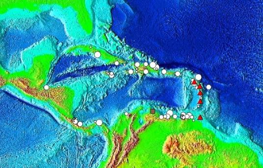
Graphic credit above: "
Tsunami source locations in the
Caribbean Sea. The symbols indicate the cause of the tsunami: Brown
Square is a landslide, Red Triangle is a volcanic eruption, Question
Mark is an unknown cause, and White Circle is an earthquake."
New U.S. Commission Would Try To Improve Weather Forecasting.
Are we losing our meteorological sensing/prediction edge to the
Europeans? There's a fair amount of angst and paranoia lurking out
there.
Scientific American has a blog post focused on steps being taken to help the USA maintain it's weather-edge; here's an excerpt: "
Despite the ever-present caveat that predicting the weather
is a difficult and inexact science, it seems that forecasts have
been getting better and better. Yet some leaders in meteorology say
continued improvement is not guaranteed and could even be jeopardized
by federal spending cuts. They want Congress to fund a high-level,
national commission that would ensure that ongoing research is pursued
to protect the nation against weather threats. As recent storms
have demonstrated, individuals, towns, industries such as
agriculture and the U.S. economy itself are always vulnerable to bad
weather, from hurricanes to droughts. Advanced technologies have made
forecasting more accurate and have provided earlier warnings of impending storms, yet room for enhancement still exists..."
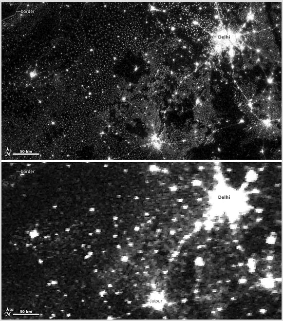
New (Higher Resolution) Satellites Show Earth At Night.
Satnews.com has a fascinating, visual story; here's an excerpt: "
A
series of new views of the Earth at Night. It was not the first time
such maps have been created, but the difference between the old view
and the new is as clear as the difference between the two images
above. On November 12, 2012, the Visible Infrared Imaging Radiometer
Suite (VIIRS) on the Suomi NPP satellite captured the
top image of city, village, and highway lights near Delhi, India. For
comparison, the lower image shows the same area one night earlier, as
observed by the Operational Line Scan (OLS) system on a Defense Meteorological Satellite Program (DMSP)
spacecraft. Since the 1960s, the U.S. Air Force has operated DMSP
satellites in order to observe clouds and other weather variables in
key wavelengths of infrared and visible light. Since 1972, the DMSP
satellites have included the OLS, which gives weather forecasters some
ability to see in the dark. It has been a highly successful sensor,
but it is dependent on older technology with lower resolution than
most scientists would like. For many years, DMSP data were classified..."
Image credit above: "
NASA Earth
Observatory image by Jesse Allen and Robert Simmon, using Suomi NPP
VIIRS and DMSP OLS data provided courtesy of Chris Elvidge (NOAA
National Geophysical Data Center). Suomi NPP is the result of a
partnership between NASA, NOAA, and the Department of Defense." Caption by Mike Carlowicz.
The Chemistry Of Snowflakes. Here's an interesting, enlightening video from
The American Chemical Society: "
The
video tracks formation of snowflakes from their origins in bits of
dust in clouds that become droplets of water falling to Earth. When the
droplets cool, six crystal faces form because water molecules bond
in hexagonal networks when they freeze. It explains that ice crystals
grow fastest at the corners between the faces, fostering development
of the six branches that exist in most snowflakes. As snowflakes
continue to develop, the branches can spread, grow long and pointy, or
branch off into new arms. As each snowflake rises and falls through
warmer and cooler air, it thus develops its own distinctive shape." Photo: Star Tribune.
The Emperor Of All Identities. If the service is
"free" chances are you, and your data habits, preferences and history,
are the cost of entry. Keep in mind the author represents Google
competitor Microsoft, among others. Here's a snippet of an eye-opening
Op-Ed about Google's business model in
The New York Times: "...
But
we need to look at Google’s market role — and behavior — through a
different prism. Google is not just a “search engine company,” or an
“online services company,” or a publisher, or an advertising platform.
At its core, it’s a data collection company. Its “market” is data by,
from and about consumers — you, that is. And in that realm, its role is
so dominant as to be overwhelming, and scary. Data is the engine of
online markets and has become, indeed, a new asset class. In March,
when Google replaced the more than 60 privacy guidelines that governed
its products and services with a single policy, it also moved to
consolidate the personal data it collects..."
The Future Of Television Has Arrived. It's Called The iPad. Here's a clip of an article that caught my eye at
The Verge: "
The
future of the television is the iPad. That was the overwhelming
message at the TV of Tomorrow conference in New York, which saw
executives and decision makers from across the television industry
gather for a lively day of discussion and debate about the state and
direction of their business. And almost all of that discussion
revolved around the iPad, which has become interchangeably known as
the "second screen." Apple may call its TV efforts a "hobby," but the
TV industry is already making huge bets on iOS. Tablet users were a
dominant theme of the conference, which featured sessions titled
"Measuring the Multiplatform Viewer" and "Second-Screen Content: Have
We Created A Monster?" Barry Frey, a former Cablevision executive,
opened a panel called "TV's New Gateway" by asking "How many of you
are taking notes on the second screen?" A room full of suits waved
their iPads in the air. "The experience of television is moving off the
primary screen," said Dale Herigstad, chief interaction officer at
design firm Possible..."
Can Your Tablet Do This? A friend sent me this
YouTube clip.
It's in German, and my German only kicks in after the third glass of
fine Octoberfest beer, so we won't go there. Thankfully the video
tells the tale. I'm not sure, but I suspect it's....magic.
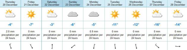
 Calm Before The Flakes
.
Admit it, 32 felt pretty good yesterday. Where else (except for maybe
Fairbanks or Fargo) would 32 F. qualify as a "warm front"? Highs were
5-10 degrees above average, statewide. St. Cloud only has 2" of snow on
the ground.
Paul's Conservation Minnesota Outlook for the Twin Cities and all of Minnesota
TODAY: Winter Weather Advisory
southern/eastern suburbs. Coating-3" snow possible (heaviest amounts
south/east of MSP). Northern/western suburbs will see a coating to 1"
Icy. Winds: NW 15-30. High: 21 (falling by afternoon - wind chills dip
to near zero at times).
THURSDAY NIGHT: Clearing, very cold. Low: 5
FRIDAY: Cold sun, winds ease. High: 18
SATURDAY: Dim sun, not as harsh. Low: 10. High: 26
SUNDAY: Patchy clouds, good travel weather. Low: 12. High: 23
CHRISTMAS EVE: Mostly cloudy. VFR conditions for Santa's arrival. Low: 14. High: 25
CHRISTMAS DAY: Dry and chilly with more clouds than sun. Low: 15. High: 23
WEDNESDAY: Storm stays south/east of MN. Cold! Low: 4. High: 15
Climate Stories...
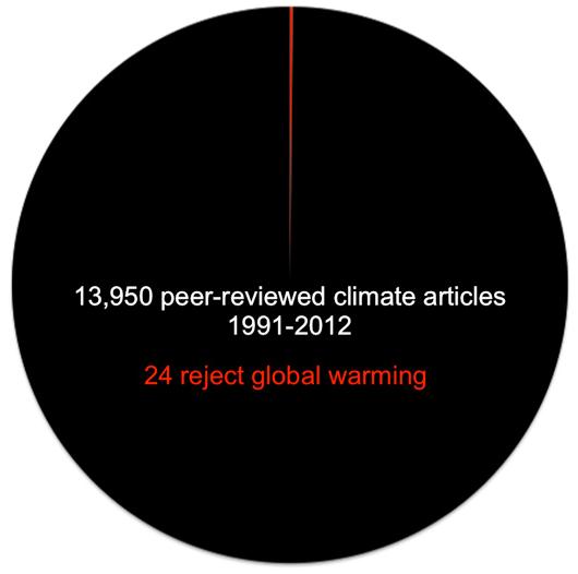 Why Climate Change Denial Is Just Hot Air
. Here's an excerpt of a story at
Slate that tries to put climate skepticism into perspective: "
I was thinking of writing a lengthy post about climate change denial
being completely unscientific nonsense, but then geochemist and National
Science Board member James Lawrence Powell wrote a post that is basically a slam-dunk of debunking.
His premise was simple: If global warming isn’t real and there’s an
actual scientific debate about it, that should be reflected in the
scientific journals. He looked up how many peer-reviewed scientific papers were published
in professional journals about global warming, and compared the ones
supporting the idea that we’re heating up compared to those that don’t.
What did he find?..."
Graphic credit: "
The thin red wedge." Image credit: James Lawrence Powell
Finland Study Tracks Global Warming Impacts On Bird Populations. Here's an excerpt from a story at
The Summit County Citizens Voice: "
Researchers
in Finland say they’ve documented bird populations trends that are at
least partly linked with global warming. Comparing data from
extensive bird counts conducted between 1981 to 1999, and 2000 to
2009, the biologists said that, in general, northern species have
decreased and southern species increased. Mean temperatures in Finland
rose between the two periods, with April to June mean temperatures
climbing by 0.7 degrees Celsius. According to the study, population
densities of common forest habitat generalists remained the same
between the two periods, while densities of species of conservation
concern showed contrasting trends. Species preferring old-growth or
mature forests increased, but those living on mires and wetlands, and
species of Arctic mountains decreased..."
5 Reasons Why Global Warming Is More Terrifying Than You Think. Here's a clip of a story from Alternet and
Salon: "
Unless
more of us join in their efforts and create new ones of our own,
we’ll be headed toward a disaster in which no amount of canned goods
or personal bunkers will save us. Here are five scary reasons things
may be about to get a whole lot worse.
1. Flesh-Eating Fungi
This would rank near the top of my list of horrors if I could
have even fathomed that such a thing exists. But it does. After a
powerful tornado hit Joplin, Missouri last May, 13 people were infected
with Apophysomyces — five of them died. Melissa Breyer reports for
Treehugger that Apophysomyces is “a common fungus that resides in
soil, wood or water and generally leaves people well enough alone. But
when it finds it way into the body, say, through blunt trauma or a
puncture wound, say, suffered in a tornado … it can grow quickly if the
proper medical response is not immediately administered....”
Four Steps Toward A Climate-Friendly Diet.
Markeplace has the story (and audio clip); here's an excerpt: "
One
of the biggest contributors to global warming is the food-supply
system, from the fertilizer and gas used to cultivate farms to
transportation and storage to what we throw away at the end of a meal.
We won’t stop climate change through individual action alone, but
together, we can make a real difference. Here are four simple things we
can do in changing the way we consume:
1. Eat less meat and dairy, especially beef and
lamb. Livestock are by far the biggest producers of greenhouse gases
in the global food system. In the U.S., most livestock-related
emissions come from the animals’ digestive systems and from the
fertilizer used to grow their feed. If an American family of four ate
no meat or cheese one day a week, it would be like taking a car off
the road for five weeks a year, according to estimates by the Environmental Working Group. If we all did it, it would be like not driving 91 billion miles..."
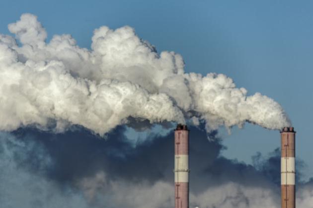
Global Warming: Eastern U.S. To See More Heatwaves, Rain. Here's an excerpt of a story at
The Summit County Citizens Voice: "
As
climate models become more sophisticated, researchers have started to
fine-tune global warming impacts to the regional level, including
more drought and water shortages expected in the Southwest, seasonal
ice-free conditions in the Arctic, and hotter, wetter conditions in
the Eastern U.S., according to a new University of Tennessee study...."
Image credit above: "
University of Tennessee researchers
say the eastern U.S. can expect more heatwaves and increased
precipitation in a warming world." Image courtesy NASA.
Climate Change Is Killing Economy: Here's How To Stop it. Not my words, but a story at
CNBC.com; here's an excerpt: "
Congress
this week is considering a $60 billion bill to pay for damages
inflicted by Superstorm Sandy across three Northeastern states in late
October. Though some Republican congressional members are balking at
the sum, which the White House is requesting, New York, New Jersey
and Connecticut say the damage is even greater, closer to $82
billion. In either case, these sums are nothing compared to the
long-term price the U.S. will pay as a result of extreme weather
caused by climate change, says Michael Hanemann, an economics
professor specializing in climate change at Arizona State University.
"What we're going to experience is unprecedented in human history in
terms of the type of climate we're creating for ourselves," Hanemann
tells The Daily Ticker. "The rate of warming has increased maybe
five times what it was in the early part of the 20th century. The
earth is getting warmer faster..."
10 Places Climate Change Kills The Most People. This is one list no country wants to be on (China is #1)
Marketwatch.com has the story - here's a clip: "
Global
climate change and pollution from the use of fossil fuels killed
nearly 5 million people around the world in 2010, according to a report
released earlier this year by climate change advocacy group DARA. By
2030, this figure will rise to nearly 6 million deaths, the group’s
second annual climate vulnerability monitor estimates. Total global
costs, which were estimated at more than $600 billion in 2010, are
expected to rise to $4.35 trillion by 2030..."


No comments:
Post a Comment