25 F. high in the Twin Cities Monday.
26 F. average high for December 17.
35 F. high on December 17, 2011.
Trace of flurries fell at KMSP yesterday.
+8 F. December temperatures are running 8 F. warmer than normal.
Subzero lows likely in and around the metro area by New Year's Eve.
A Few Close Calls?
December often sets the tone for the winter to
come; a prevue of coming attractions. Two years ago today 14 inches of
snow was on the ground. A whopping 33.6 inches fell in December of 2010.
As you may remember, that was a Real Winter, with over 86 inches of
snow by April, followed by record spring floods.
This winter? I'm not feeling it. A weak El Nino
warming of Pacific Ocean water seems to be nudging the main storm track
south/east of Minnesota. A major storm may dump a few inches of snow on
far southeastern Minnesota Thursday; a big pile of white for Rockford
and Madison. But probably not in the Twin Cities, where an inch of slush
may fall today, little more.
Our biggest snows often come in December and
February, on the cusp of the coldest air Canada can dish out.
Historically, our coldest weather comes the 3rd week of January; massive
domes of bitter air tend to shove the storm track too far south for
heavy snow in January. We'll see.
Whatever crunchy, icy snow is in your yard today should still be there Christmas morning.
Another near-miss on December 26, along the
leading edge of the first subzero airmass of winter.
Negative numbers
for New Year's Day? I think so.
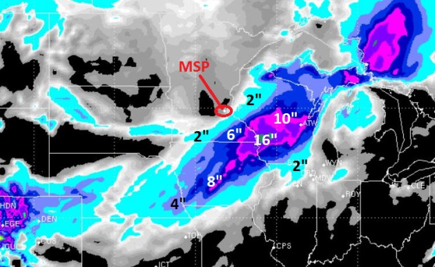
Heaviest Snow Bands on Thursday. The ECMWF
(European) and WSI's 12 km. RPM models have been doing the best job
recently. The 00z RPM guidance is above, hinting at some 4-10" snowfall
amounts east of Rochester, closer to Winona and La Crosse - as much as
16" over southwestern Wisconsin. So close, and yet so far.
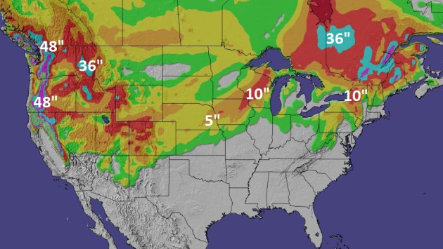
192 Hour Snowfall. This is GFS guidance, which shows
Thursday's stripe of heavy snow from Iowa into Wisconsin, maybe
brushing far southeastern Minnesota. Northern New England will pick up
some accumulating snow over the next 8 days; some 36-48" amounts for the
mountain ranges of the Pacific Northwest. Map: Ham Weather.
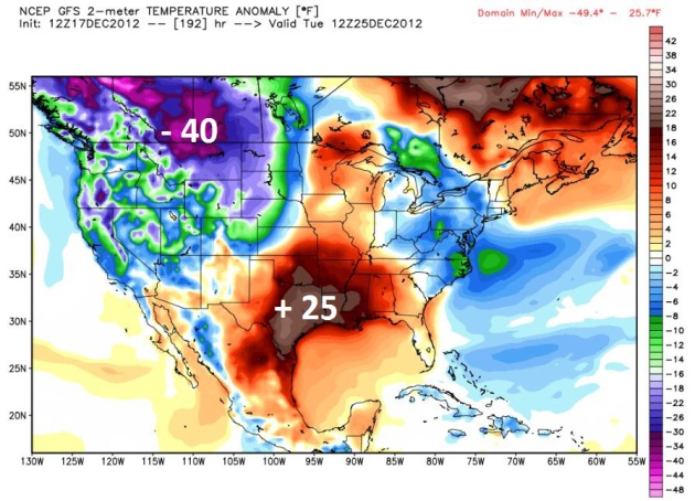
Christmas Day Extremes. The map above shows
predicted temperature anomalies for December 25; readings as much as 25
F. warmer than average over the Southern Plains, the first (real) cold
stab of winter pushing into Montana and the Dakotas. These huge
temperature extremes may conspire to spin up a major storm 1-2 days
after Christmas.
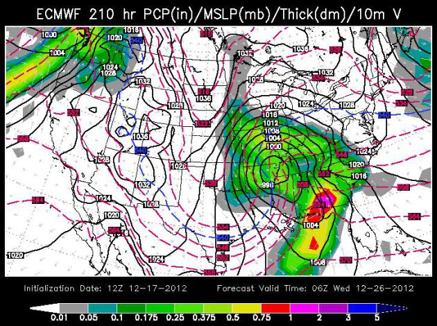
December 26-27: Major Tornado Oubreak Southeastern USA?
The map early Wednesday, December 26, shows a very intense and large
storm centered near Memphis, pulling unusually warm, moist air
northward. There may be sufficient wind shear and low level
moisture/instability for a few (large) tornadoes from near Atlanta into
Alabama and Florida, while heavy snow falls from Kansas City to Peoria.
This storm will probably track south/east of Minnesota - it's simply too
early to say with any confidence. ECMWF model guidance above courtesy
of WSI.
Cold and Quiet. No big, exciting storms brewing
between now and Christmas (unless you're driving 2+ hours south/east of
MSP Wednesday night into Thursday, in which case you'll have plenty of
weather drama. A snowstorm is a delicate dance of Canadian chill and
Gulf moisture. Too much of either spoils the recipe. The surge of colder
air will push the heaviest snow band 100-300 miles southeast of MSP
Thursday - a cold weekend gives way to slight moderation in time for
Christmas. ECMWF data for MSP above.
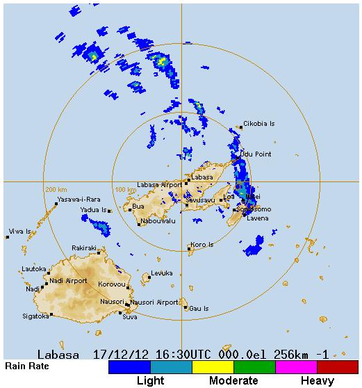
Category 3 Cyclone Evan Bearing Down On Fiji. Here is an excerpt from Dr. Jeff Master's
Wunderground: "
Category 3 Tropical Cyclone Evan is closing in on the main island of Fiji, where hurricane warnings are flying and torrential rains are already falling. Radar images from Fiji
show that the large eye of Evan is just north of the two main islands
of Fiji. The expected southwesterly track of the storm should keep the
calm of the eye just north of Fiji, though the southern eyewall may
brush the north coast of the main island of Vici Leva, affecting the
tourist town of Nadi. Evan has intensified today to its strongest level yet, with 120 mph winds, and satellite loops
show that the storm remains well-organized, with plenty of intense
heavy thunderstorm activity and a prominent eye. Evan will be in a
region with moderate wind shear of 15 - 20 knots as it approaches Fiji,
and could intensify by another 5 - 10 mph before making its closest
pass to the islands later today. According to NOAA's Coastal Services
Center, Evan is the strongest tropical cyclone to threaten Fiji since
Tropical Cyclone Daman of December 2007. Dating back to 1972, twelve Category 3 or stronger tropical cyclones have threatened the Republic of Fiji..."
Radar image above from the
Fiji Meteorological Agency. Click refresh on your browser to see the latest image.
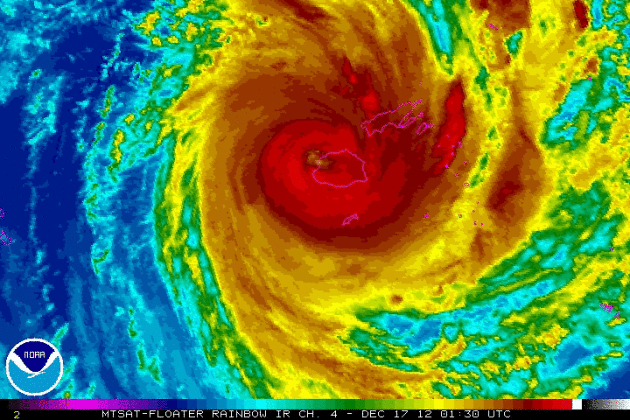
Cyclone Evan. A Category 3 hurricane/typhoon/cyclone
(same thing), Evan caused major damage on American Samoa. The latest
enhanced IR satellite loop from NOAA is
here.
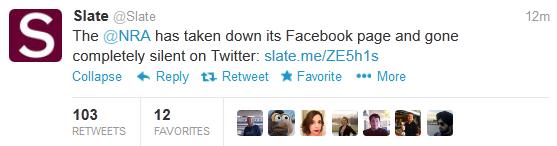
Slate has details
here.
World's Largest Indoor Ski Park Planned For Denmark. Good grief - they just keep getting bigger and bigger. Check out the details at
gizmag.com: "
Innovative
Danish architecture firm CEBRA is working in collaboration with the
travel company Danski on an alpine style ski dome to be situated in the
city of Randers, Denmark. The ski park will provide over 3 km (1.86
miles) of indoor and outdoor slopes as well as a freestyle park, hotel,
restaurant and all the modern facilities you would expect in a modern
ski resort..."
Image credit above: "
The snowflake design will house six indoor and two outdoor slopes in its three intersecting arches." (Photo: CEBRA)
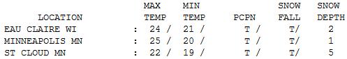
Almost Average. Temperatures were within a couple
degrees of normal statewide, stuck in the low to mid 20s. Snow on the
ground ranges from 1" in the Twin Cities (officially) to 2" Eau Claire
to 5" at St. Cloud.
A Much-Needed Chuckle. Thanks to meteorologist Jason Parkin and
neatorama.com for passing this one along. I wonder if he got a dial tone on that thing...?
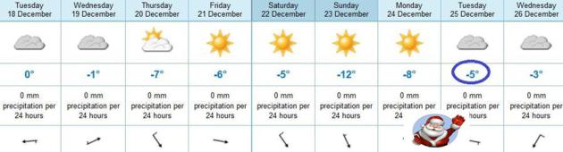
Paul's Conservation Minnesota Outlook for the Twin Cities and all of Minnesota
TODAY: Flurries and very light snow possible. Coating to 1/2" possible. Winds: S 5-10. High: 32
TUESDAY NIGHT: Flurries taper off. Low: 18
WEDNESDAY: Mostly cloudy, still dry. High: 29
THURSDAY: Cold wind. Clouds, a few flurries in the metro. 4-8" possible far southeast MN. Low: 12. High: 20 (falling)
FRIDAY: Some sun, a bit milder. Low: 10. High: 23
SATURDAY: Patchy clouds, turning colder by afternoon. Low: 16. High: 25
SUNDAY: Sunshine, a numbing breeze, much colder. Low: 5. High: 15
CHRISTMAS EVE: Sunny start. Increasing clouds, probably dry on Christmas Eve. Low: 8. High: 19
CHRISTMAS DAY: Patchy clouds, temperatures closer to normal. High: 23
* photo above courtesy of andfunforall.blogspot.com.
Climate Stories...
Climate Change Revisited: It Isn't Just For Natural Scientists Anymore. Here's a snippet of an
NPR article that caught my eye: "...
Does
current psychology shed any light on how to move forward? I asked
Lewandowsky this very question during our conversation. He first
suggested that "highlighting how denial operates" is itself an important
part of getting people behind climate change:
You have to understand who the people are who deny the science
and how they operate and what drives them. We know from a lot of
research on misinformation that without explaining ... why people
oppose it so much, it's very difficult for the average person to accept
the science because the moment there is the perception of a scientific
debate people sort of tend to walk away from it and say, "well, it's
not settled."
In other words, people need to understand why there is the
appearance of controversy in order to feel confident moving forward
with (uncontroversial) scientific assumptions. In other research,
Lewandowsky has found that merely alerting people to the existence of
an enormous scientific consensus can shift beliefs..."
Amid Energy Crisis, A Need To Define And Promote Innovation.
The Christian Science Monitor has the story - here's an excerpt: "
The United States
and the world face an urgent imperative to transform its energy system
by developing and deploying low or zero-carbon technologies on a
dramatic scale. And while developed regions like the United States and Europe
might be willing to change their consumption patterns and businesses
to incorporate clean energy (though not significantly), developing
nations can’t afford to pay the necessary premium for this access. And
they shouldn’t have to, as they try to gain access to energy of any
kind. As such, the only way the entire global energy system can
transition to clean energy is if its cost is lower and its performance
is equal to or greater than cheap fossil fuels like natural gas, coal,
and oil..."
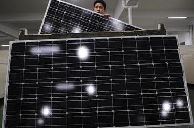
Photo credit above: "
An employee carries a solar panel as
he works at a production line at a solar company workshop in Yongkang,
Zhejiang province in this February 2012 file photo. Global climate
change adds an economic, moral, and social element to why governments
must aggressively act on energy innovation." Stringer/Reuters/File.
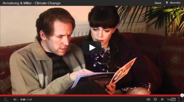
Denying Global Warming Because It's Raining? Or
because it's cooled down a few degrees? It's remarkable how many people
still confuse "weather" (what's happening out your window today) with
"climate" (long term trends). This funny clip from
upworthy.com sums it up better than I ever could. Check it out. "
I
was almost happier before I realized this video was a joke, when I
thought England was actually penalizing these people. But even as a fake
PSA, it's still so spot on, eh?"


No comments:
Post a Comment