By Paul Douglas
Our bodies are composed mostly of water, so maybe it's in our DNA to want to be near H2O. It took me years to comprehend the whole "Up North Experience"; people slogging 2-4 hours to their cabins, their own personal Slice of Heaven.
Sandy highlighted the inherent perils of living next to the ocean. The U.S. west coast is not immune from catastrophic flooding, either. New research points to "atmospheric rivers", stalled ribbons of (extreme) water vapor, snaking thousands of miles long into the Pacific - spawning a Conga Line of wet storms. One such fluke event created new lakes in 1861, bankrupting the young state of California, according to a Scientific American study (blog). They seem to strike every 200 years.
More flooding hits northern California today, while we muddle through a deepening drought. Skies brighten with a shot at 50F today - 60F isn't out of the question Monday, as south winds surge ahead of the next cool front.
Jackets return by midweek but I don't see any bitter air looking out into mid-December. Seasonably cold.
Lo and behold, long-range models hint at "accumulating snow" a week from today; maybe a couple inches? Time to call out the National Guard.
______________________________________________________________________________________
Freezing Fog Thru AM Sunday
...FREEZING FOG ADVISORY IN EFFECT FROM 3 AM TO 9 AM CST SUNDAY...

THE NATIONAL WEATHER SERVICE IN TWIN CITIES/CHANHASSEN HAS ISSUED
A FREEZING FOG ADVISORY...WHICH IS IN EFFECT FROM 3 AM TO 9 AM
CST SUNDAY.

* VISIBILITY...1/4 MILE OR LESS.

* TIMING...FOG WILL DEVELOP THIS EVENING AND BECOME DENSE FREEZING
  FOG LATE TONIGHT AS TEMPERATURES FALL TO...OR BELOW FREEZING.
  THE FOG SHOULD LIFT BY MID MORNING SUNDAY.

* IMPACTS...DENSE FOG WILL MAKE FOR DIFFICULT DRIVING LATE TONIGHT
  AND SUNDAY MORNING. IN ADDITION...WITH TEMPERATURES AT OR BELOW
  FREEZING THERE MAY BE LIGHT ICING ON UNTREATED SIDEWALKS AND
  ROADWAYS...ESPECIALLY ON BRIDGES AND OVERPASSES. THE BEST CHANCE
  FOR THIS ICING WILL BE OUTSIDE OF THE TWIN CITIES METRO.

Todd's Conservation MN Outlook for the Twin CIties and all of Minnesota:
SUNDAY: Partly sunny, feels like late October. High: 50
SUNDAY NIGHT: Increasing clouds. Low: 32
MONDAY: Springlike early. Passing shower possible, colder later in the day. High: 59 (by midday, then falling)
TUESDAY: Clearing, turning cooler. Low: 41. High: 42
WEDNESDAY: Jacket weather, clouds increase. Low: 26. High: 41
THURSDAY: More clouds than sun. Low: 26. High: 41
FRIDAY: Intervals of sun, cooling off. Low: 31. High: 37
SATURDAY: Blue sky, clouds arrive late. Low: 25. High: 29.
________________________________________________________________________________________
It's Winter Somewhere
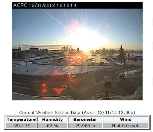
I think there's a saying that goes "It's 5 o'clock somewhere" isn't there? Even though it doesn't feel like winter around here, it really is somewhere. Take a look at the Arctic webcam from Fairbanks, Alaska where the midday temperature was a balmy -20F on the 1st day of December (first day of Meteorological Winter). As a general rule of thumb, when Alaska is cold, we are typically warm.
Here are some of the latest numbers on how November faired for some selected cities:
Pittsburgh, PA: 0.38″ in November, 3rd driest (normal 3.23″)
Shreveport, LA: 0.85″ in November, 12th driest
Tyler, TX: 0.28″ in November, 3rd driest
Tampa, FL: 0.16″ in November, 11th driest (normal: 1.55″)
Columbus, OH: 0.79″ in November, 5th driest
Nashville, TN: 1.38″ in November, 17th driest
Houston, TX: 0.65″, 6th driest
Jackson, KY: 0.84″, 2nd driest
Jacksonville, FL: 0.27″, 13th driest
Fairbanks, AK: Ave Temp: -8.8 (6th coldest), Ave High 0.4 (10th coldest), Ave Low: -17.9 (3rd coldest)
Dallas, TX: 0.05″, 5th driest
Danville, VA: 0.54″, 2nd driest
Savannah, GA: Ave High 66.8, Ave Low 43.2 — 6th coldest Nov on record
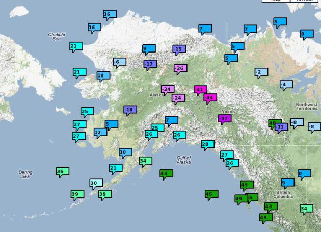
Alaska's Arctic Temperatures
This isn't all that unusual for Alaska at this time of the year, but the numbers are still a bit startling. Interior Alaska has been consistently in the -20s and -30s, but some of the overnight lows as of late have been down in the -40s and -50s... YIKES! The map below shows some of the minimum temperatures recently recorded. See more from the NWS mesonet observation page HERE:
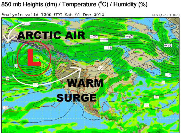
When Alaska's Cold, We're Typically Warm
This isn't always the case, but it's a pretty good rule of thumb. A large Pacific storm (sitting nearly stationary) has been pushing copious amount of Pacific moisture into the west. This constant barrage has been responsible for flooding along the West Coast, but has also helped in warming things up across the nation's midsection. This storm is also responsible for the cold Arctic air entrentched across Alaska.
Mild Midsection of the Nation
By contrast, take a look at how mild it was recently across the Lower 48, specifically the nation's midsection. Temperature have been running well above average... 40s, 50s, 60s and even 70s doesn't seem like typical December weather does it?
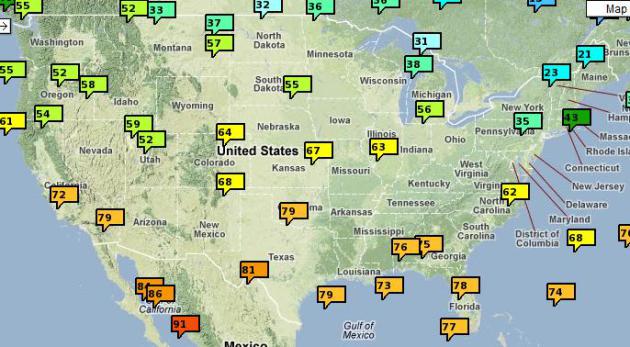
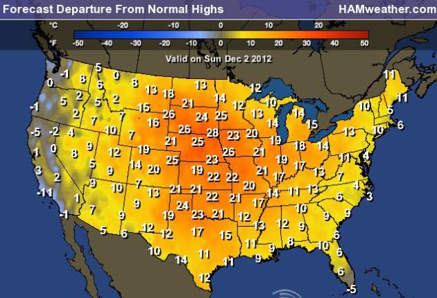
YIKES! That's Not Normal
This map is anything but normal. The high temps from normal map shows that much of the nation on Sunday will be above normal by quite a margin, in some cases nearly 20F to 30F above normal!
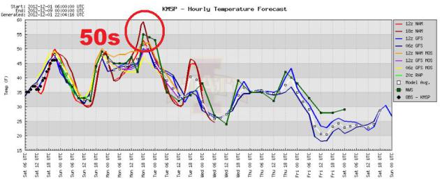
Mild in Minneapolis
Take a look at the 7 day temp trend for Minneapolis, MN - temps are expected to be in the 50s by Monday ahead of a cold front. Even though this will be well above average, the record high for Monday is 62F set in 1962. Post cold front, the temperature drops a bit through midweek, but with an average high around 30F, we should still be above that through most of the week.
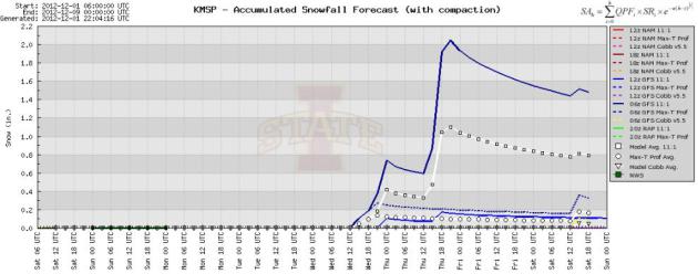
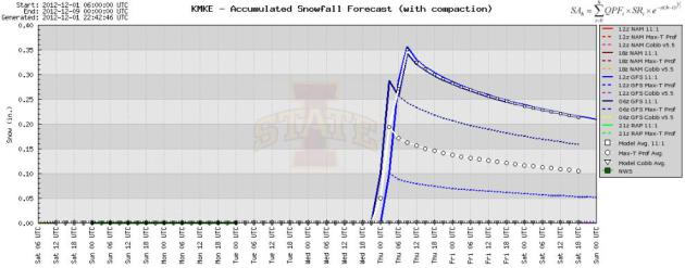
Minneapolis Snow Potential?
It is December after all, so why not a little snow? The snow season is off to an awfully slow start in the Twin Cities. We've only seen 0.8" of snow, which is more than 9" behind normal snowfall for the season. December averages 11" of snow and the annual average is nearly 52" for the Twin Cities. We're quite a bit behind average already, but there's still lots of time to make it up. The extended forecast shows some cooler weather by the end of the week and a slight chance of light snow. Some of the models are hinting at a light dusting? We'll see what happens.
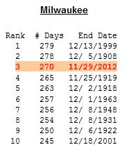
Milwaukee, WI Still Snowless
Our snowless streak continues in Milwaukee, WI. March 4th was the last time there was measurable snow making it the 3rd longest stretch without measurable snow. If we can make it to Sunday, December 9th, that'll be 280 days without measurable snow and the longest stretch without such in recorded history... the countdown continues. See more HERE:
Snow Potential in Milwaukee?
The same models that are predicting snow for minneapolis are predicting a little snow for Milwaukee by mid/late week as well.
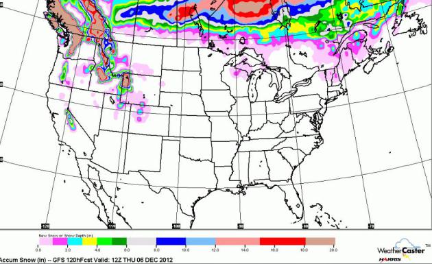
US Snow Potential
According to the GFS, there is little snow potential across the nation through AM Thursday. Other than the high elevations out west, much of the Lower 48 stays mostly snow free.
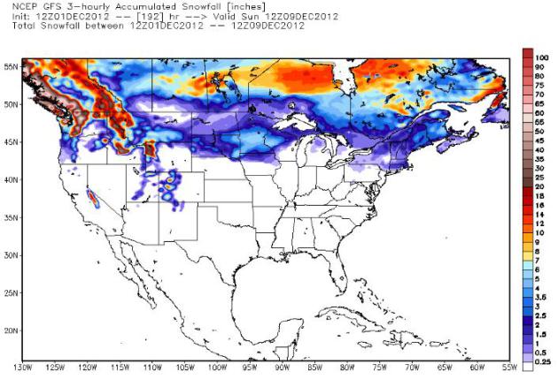
Long Range Snow Potential
Here's the long range GFS snow potential thru next Sunday. Although this is considered to be a little 'fantasyland' forecasting, this too shows minimal snow potential through the first full week of the month.
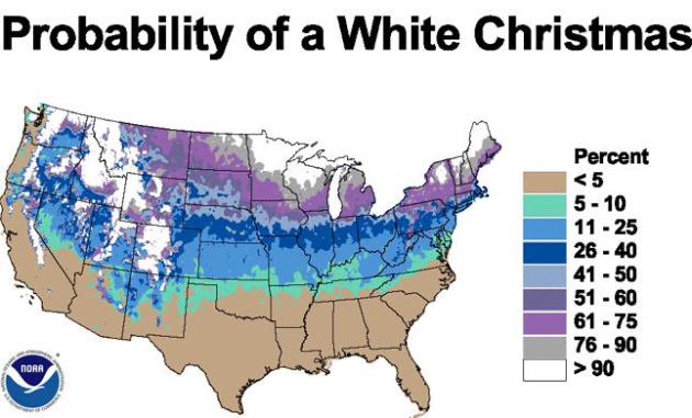
Probability of a White Christmas
For folks hoping for a white
Christmas, the good news is that we still have lots of time to get that
coating and we have climatology on our side! There are many folks across
the northern tier of the nation that typically see a white Christmas,
which is considered to be at least 1" of snow on the ground on Christmas
day.
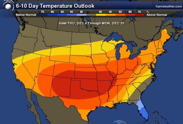
Looking Ahead...
The 6 to 10 day temperature
outlook keeps chances of warmer than normal temperatures across much of
the nation through next weekend. That'll take us through the first
one-third of the month without typical December weather.
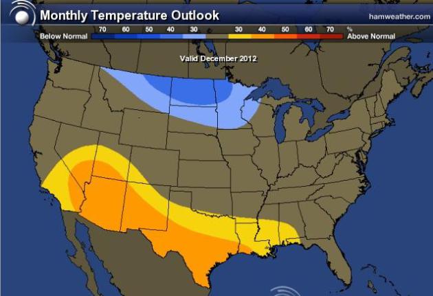
December Monthly Temps
Looking out through the month,
the outlook does cool things off a bit across the Upper Mississippi
Valley and the High Plains. It's hard to say exactly what is going to
happen through the entire month, but for those who enjoy winter weather,
we are certainly starting off on a bad note. The question is... when is
the shoe going to drop and when it does, is it going to land with a
BIG thump?
Thanks for checking in, have a great rest of your weekend.
Don't forget to follow me on Twitter @TNelsonWNTV

No comments:
Post a Comment