33 F. high in the Twin Cities Monday.
25 F. average high for January 28. The average high has risen 2 degrees F. since mid-January. Can spring be far behind? Yep.
28 F. high on January 28, 2012.
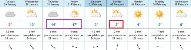
-10 to -13 F. low predicted for Friday morning (air temperature). Low 30s return by Sunday.
54 minutes of additional daylight since the Winter Solstice on December 21.
Weather Cues
Predicting the weather is a little like trying
to make sense of the stock market. Financial analysts run models, they
look at projected earnings & competitive risks when evaluating
whether a stock should go up or down.
Meteorologists examine models, look for
agreement (continuity), always on the lookout for "Black Swan Events".
Sandy comes to mind.
But weather models only go so far. Things as
seemingly random as melting arctic ice and "sudden stratospheric
warming" can nudge Minnesota's weather in a certain direction. Last
year's La Nina cooling phase of the Pacific may have made our drought
worse.
Now comes news from NOAA that a weak La Nina
should become "ENSO-neutral". No warming or cooling, which MAY loosen up
the blocking patterns keeping moisture-laden storms from dumping heavy
rain and snow on our farms, gardens and lakes. "Improvement" in the
drought is predicted by late April.
My fingers (and eyes) are crossed.
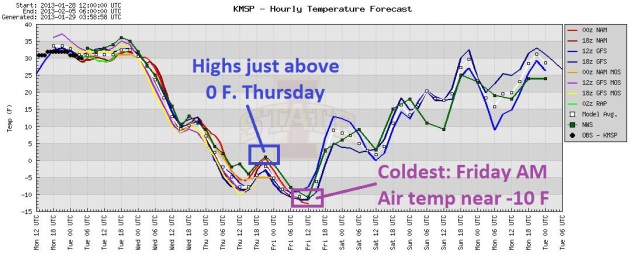
We wake up to a snowy coating; today the last
day you can feel your extremities this week. A "high" near zero Thursday
gives way to -13 F Friday morning.
Before you let out another primal scream consider this: no subzero lows showing up in February. It WILL warm up.
Imminent Temperature Tumble. Enjoy low 30s again
today, because temperatures will drop like a rock tomorrow; highs on
Thursday close to zero. We bottom out Friday morning around -10 F before
temperatures rebound next weekend. Yes, it's going to get cold, but not
quite as cold, for as long, as last week. Graphic: Iowa State.
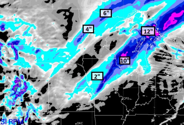
Snowfall Potential. Parts of western and northern
Minnesota are waking up to a few inches of snow this morning, little
more than a coating from St. Cloud to the Twin Cities. A surge of much
colder air spins up another smear of snow from Iowa into Wisconsin by
tomorrow, a couple inches for Des Moines, as much as 6-10" for
southwestern Minnesota, maybe 3-4" for Madison. Map: WSI RPM Model.
Next Front: Not Quite As Arctic. This may be the
last ("get me out of here") Arctic front of winter. Don't get me wrong -
we'll see more cold fronts, probably a few more subzero nights in
February. But my sense is that last week and this week will be the worst
of winter, in terms of persistent cold. The end is near...
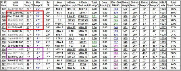
Feeling Better About February. ECMWF guidance shows
highs at or just above 32 F. by Sunday, with another run of 30s the
latter half of next week. The GFS model shows a brief burst of subzero
around February 12, maybe one night below zero, but nothing like the
past 7-10 days. Significant snow? Are you kidding me?
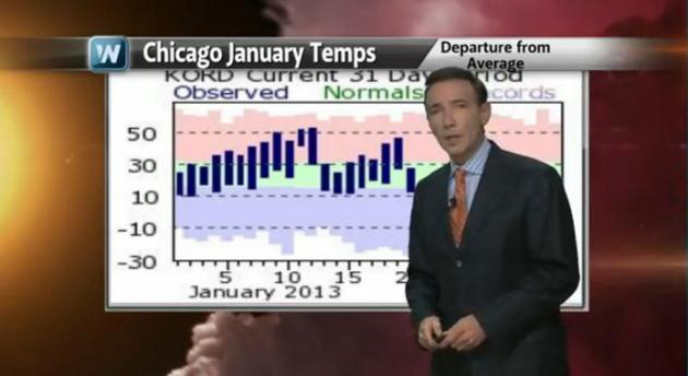
Winter Or Spring? Wild January Temperature Extremes. Here's my latest edition of "
Climate Matters", focused on some of the surreal swings in temperature the USA has been witnessing in recent weeks: "
Many
cities have seen quite a smorgasbord of temps to start the year.
Tucson and Los Angeles had record lows one week followed by record
highs. Now Chicago is flirting with 60 degree temps in January after
sub zero temps just days ago. What do you make of this weather Roller
Coaster ride in January?"
How Does Melting Arctic Sea Ice Affect The Weather?
Picking up on the theme of major temperature extremes above, here's a
possible link with record Arctic sea ice loss last September, courtesy
of
Penn State Live: "...
In
the middle latitudes -- where most people live -- the changes in sea
ice cover and its reduced thickness can result in greater fluctuations
in the weather during the winter, and also larger year-to-year
variations, explains Carleton. "For example, the warming of the Arctic
atmosphere can enhance blocking high pressure systems in the
Greenland-Iceland area during winter and spring," he notes. "On either
side of a blocking high, a cold trough of low pressure usually amplifies
in eastern North America and also over Europe, leading to more
unusually cold and snowy conditions in those places, such as we had
during the winter of 2010-11..."
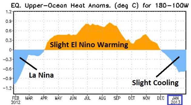
NOAA Outlook: "ENSO-Neutral" Into Mid-2013. Who
cares whether the Pacific Ocean is getting warmer or cooler? Last year
we had a mild to moderate La Nina cooling phase, which correlates with
more severe drought over the central U.S. We wound up with the worst
drought since 1956, bone-dry weather continues to cause problems over
the Plains and Upper Midwest. So a forecast of ENSO-neutral, a gradual
weakening of the current (slight) La Nina cooling signal, might increase
the odds of breaking out of this dry rut, once and for all. Details
from NOAA
here.
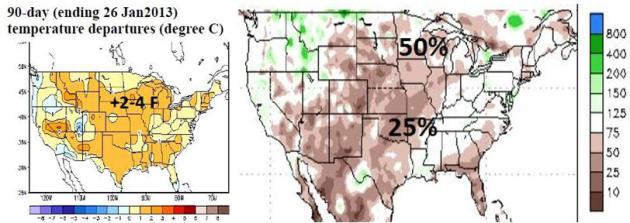
90 Day Trends. According to
NOAA
temperatures have been running considerably warmer than average since
late October over most of the USA, even factoring in the recent series
of cold waves. The map in the upper left shows a + 2-4 F. temperature
anomaly over the last 90 days. It won't comes as a shock to hear that
precitation over the Red River Valley and roughly the southern third of
Minnesota has been half what it should have been since late October.
60 F. Today in Chicago? The last time that happened
was 2008. Since 1877 there have been only 33 January days with a
temperature of 60 F. or higher, according to NOAA.
From WGN-TV Meteorologist Tom Skilling: "
Record
warmth ahead! Also thundery downpours, potential for flooding &
possible severe weather here or nearby later Tue/Tue night & a temp
dive which could mean sticking snow Wednesday. Chicagos 60s predicted
Tuesday would a set new record for Jan 29 & be 1st 60s to occur in
January here in 4 yrs since 65 1/7/2008 & only the 35th Jan 60s in
143 yrs! The grounds frozen preventing percolation of water into
soil-thus the flood threat Tue PM & nite. Avg of model fcsts puts
total rain near 1.63″. Famously, the Blizzard of 67 Jan 26-27 occrd 2
days after mid 60s which produced powerful t-storms & even funnels
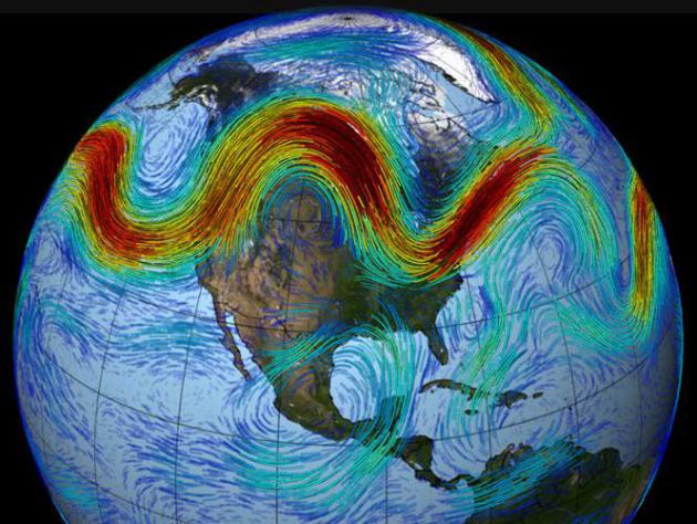
in some south suburbs.Check out Tuesdays jet stream forecast at 18,000
ft. the 500 mb. level. T-storms poking up into those powerful winds will
be fast-movers and will be able to transfer wind energy down to the
surface as powerful wind gusts."
Kansas City Heat. From the Kansas City, Missouri office of the National Weather Service: "
Through
4pm, the Kansas City International Airport has reached 74 degrees. 1
degree short of the all-time January record set on January 24, 1950 at
75 degrees. However, 9 degrees higher than today’s daily record of 65
degrees set back in 1917. The downtown airport in KC reached 76
however. Daily records have been shattered all across the region. How
have you been enjoying this preview of June? Don’t get used to it
though, as snow is in the forecast for Tuesday night and Wednesday."
RECORD EVENT REPORT
NATIONAL WEATHER SERVICE TOPEKA KS
128 PM CST MON JAN 28 2013
...RECORD HIGH TEMPERATURE SET FOR TODAY AND FOR JANUARY AT TOPEKA KS...
AS OF 123 PM...THE TEMPERATURE AT BILLARD AIRPORT AT TOPEKA WAS 75 DEGREES.
THIS SETS THE RECORD FOR THE HIGHEST TEMPERATURE BOTH FOR THIS DAY AND
FOR THE MONTH OF JANUARY. THE PREVIOUS RECORD FOR TODAY WAS 67
DEGREES...SET IN 1917. THE PREVIOUS RECORD FOR THE MONTH WAS
74 DEGREES...FIRST SET ON JANUARY 2...1939 AND THEN TIED ON JANUARY 8...2003.
ANOTHER REPORT WILL BE ISSUED IF THE TEMPERATURE CONTINUES TO RISE.
Heat From Urban Centers Can Have Far-Ranging Effect: NCAR Study. Here's the intro to a
Huffington Post story that caught my eye: "
Heat
generated through everyday activities in one urban setting can affect
the jet stream and other atmospheric systems, according to a new study
in which the National Center for Atmospheric Research was a
participant. Extra "waste heat," as it is termed in the study, generated
by buildings, cars and other sources in major Northern Hemisphere
urban centers can cause winter warming across large areas of North
America and northern Asia, researchers found. However, the study shows,
changes to atmospheric circulation caused by waste heat also cools
areas of Europe by as much as 1.8 degrees Fahrenheit, with much of that
cooling coming in the fall..."
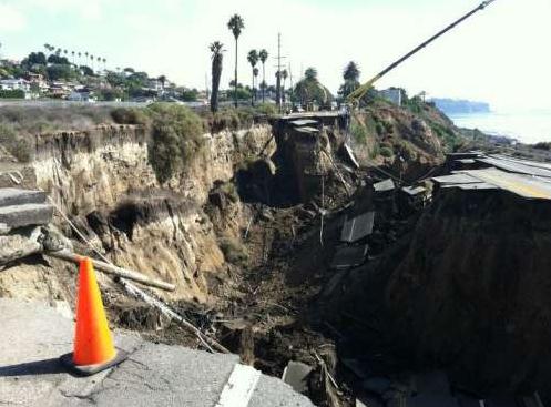
Are You Ready For Landslide Season? The short answer
is no. Some days I miss the (big) hills, and then I realize that at
least I don't have to worry about landslides, living in Minnesota.
Here's an excerpt from a story posted by USGS,
The U.S. Geological Survey: "
As
a rainy winter plods on, scientists, resource managers and property
owners from coast to coast cast worried eyes on America’s hillsides for
signs of this common natural geologic hazard – a landslide. Landslides can happen anyplacethat
has unstable hillslopes and a contributing factor such as an
earthquake, a wildfire severe enough to alter soil properties, human
modification of the landscape or, most commonly, rain. The West Coast,
particularly California, is vulnerable to landslides because of its
steeplands, its seasonal rainfall patterns, and the way its ongoing
tectonic deformation exposes vulnerable sediments,not to mention the
large population that lives in areas that could be affected by
landslides, said Lynn Highland, a geographer with the USGS National
Landslide Information Center in Golden, Colo..."
Photo credit above: "
This slide on San Pedro, Calif.,’s
Paseo del Mar began moving over a period of weeks in November 2011. On
Sunday, Nov. 20, the landslide moved abruptly, causing the roadway to
collapse." Photo by Los Angeles County Supervisor Don Knabe.
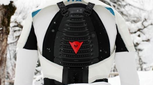
"Dainese" Fine-Tunes Its Ski Airbag System. A last
resort for crashing as you sail down the double-diamond slopes? Forget
that. I need one of these babies just to go out and get the mail on icy
days. Details from
gizmag.com: "
Besides
continuing to produce its high-end protective body armor, Dainese has
also spent the last several years developing something else – a wearable airbag system for motorcyclists.
A couple of years ago, the Italian company announced that it had
entered into a partnership with the International Ski Federation, to
adapt that system for use by downhill ski racers. Now, Dainese has announced that it is fine-tuning the ski system, for use in the Sochi 2014 Winter Olympics..."
Oxijet Air Shower Reduces Water Usage By 50% In an
era where keeping a predictable supply of clean water is going to be a
greater challenge, here's an innovation that may just show up one of
these days in Las Vegas, Phoenix or Los Angeles.
Gizmag.com has the story; here's an excerpt: "
Low-flow
shower heads are a good way to save water, but using one can be a bit
like showering with a spray bottle. New Zealand company Felton, in
collaboration with Australia's Commonwealth Scientific and Industrial
Research Organisation (CSIRO), has developed the Oxijet – an “air
shower” head that injects tiny air bubbles into the water droplets to
make the shower feel like it’s at full pressure, yet while using 50
percent less water..."
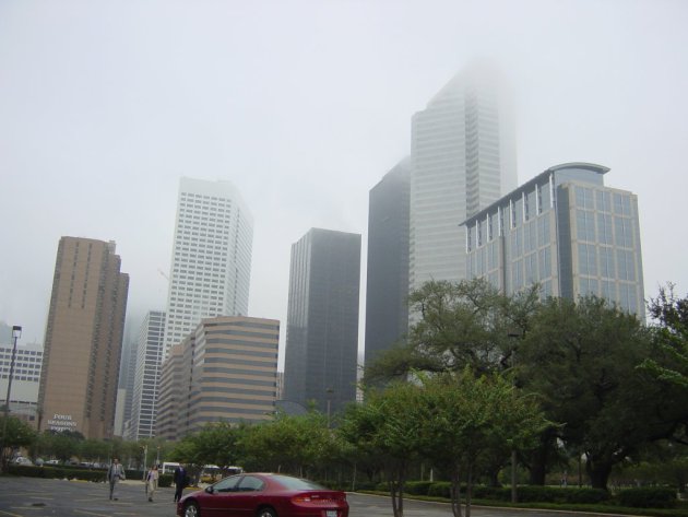
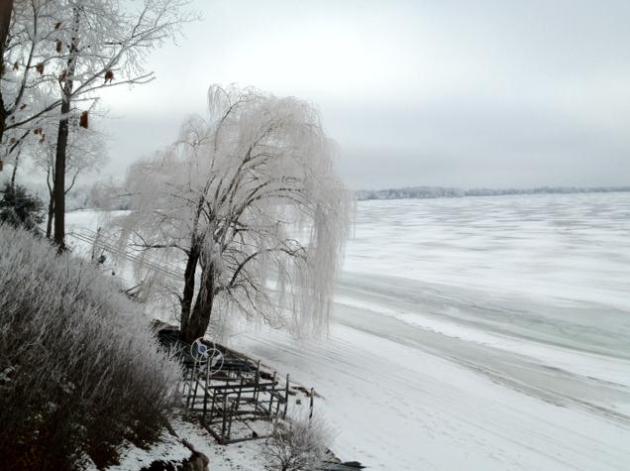
A Minnesota "Warm Front". Where else on the planet
do the locals sigh with relief when the mercury hits...freezing?
Everything is relative. After a spell of subzero 30s almost feel like a
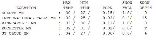
Club Med Vacation, right? With fog and drizzle highs ranged from 30 at
Duluth (9" snow on the ground) to 33 Twin Cities, 34 St. Cloud, to a
balmy 37 at Grand Marais.
Paul's Conservation Minnesota Outlook for the Twin Cities and all of Minnesota:
TODAY: Snowy coating possible early, still mild
(for Minnesota in late January). Foggy. Winds:NW 15. High: 34, falling
by afternoon.
TUESDAY NIGHT: Gusty and colder. Low: 12
WEDNESDAY: Mostly cloudy, cold wind. High: 14
THURSDAY: Last bitter day of winter? Not bad (for Siberia). WC: -25. Wake-up: -3. High: 2
FRIDAY: Ineffective sunshine. Less wind. Wake-up: -13. High: 8
SATURDAY: Mostly cloudy. Less numb. Wake-up: 7. High: 25
SUNDAY: Sighs of relief. Another thaw. Wake-up: 15. High: 34
MONDAY: Cold clipper exhaust. Gusty winds. Wake-up: 18. High: 26
Climate Stories...
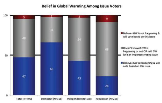
Climate Change Action Now Helps Win Elections. When
will politicians in Washington D.C. think twice about taking fossil fuel
funding and delaying meaningful action on climate change? When their
reelection depends on it. Here's an excerpt of a story at
Discovery.com:
"Politicians who oppose taking action on climate change or discount the
whole matter could be risking their careers. Public opinion in the
United States has shifted in favor of doing something about climate
change, and politicians who want to get elected need to take note of
it, according to a new study by the Yale Project on Climate Change
Communication. A nationwide survey conducted before the November
election found that concern about the effects of global warming is high
across political groups, with most Democrats and Independents
expressing concern about global warming and its potential harm for
people today as well as to future generations.
A clear majority
of registered voters, 58 percent, said they would consider a
candidate's position on global warming when deciding how they will vote...."
Graphic credit above: "
A new Yale Project poll shows how taking a stand on climate change can help politically." Yale Project on Climate Change Communication
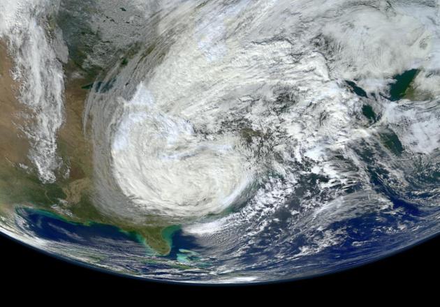
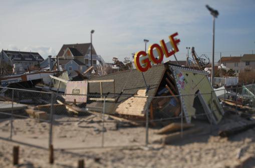
On Battered Jersey Shore, Sandy Victims Struggle With Costs Of Climate Change. Here's an excerpt from
The Christian Science Monitor: "..."
You
can't attribute Sandy to increased ocean temperatures, but the
increased intensity of the storm can be attributed to a warmer ocean,"
says Kenneth Miller, an earth scientist at Rutgers University
in New Jersey. Homeowners who do not elevate their houses "are rolling
loaded dice for extreme events." But imposing the new codes during
storm cleanup has proved chaotic. Toms River is home to 95,000 people.
Fifteen thousand homes were damaged or destroyed in the storm, nearly
half the town's housing stock and a substantial portion of the 72,000
homes and businesses that were hit in New Jersey...."
Climate Change Impacts To U.S. Coasts Threaten Public Health, Safety And Economy, Report Finds. The story from
Science Daily; here's a snippet: "...
The
report's authors noted that the population of the coastal watershed
counties of the U.S. and territories, including the Great Lakes, makes
up more than 50 percent of the nation's population and contributed more
than $8.3 trillion to the 2011 U.S. economy but depend on healthy
coastal landforms, water resources, estuaries and other natural
resources to sustain them. Climate changes, combined with human
development activities, reduce the ability of coasts to provide numerous
benefits, including food, clean water, jobs, recreation and protection
of communities against storms..."
Norway Climate Sensitivity Research Not Yet Peer Reviewed.
Could climate sensitivity be lower than the vast majority of climate
scientists have theorized? The weekend headlines showed up at the usual
denier sites. Maybe the warming has slowed or stopped, and now there's a
new Norwegian study that seems to validate that it won't be as bad as
expected! I hope they're right, but in 20/20 hindsight a few nuggets
were taken from a paper that has yet to withstand the rigor of
peer-review, as reported by
The Carbon Brief: "
A
press release last week appeared to present the results of new research
suggesting earth's climate is not as sensitive to carbon dioxide as
scientists previously thought. But Carbon Brief has confirmed that the
findings came from research by a PhD student in Oslo which has not yet
been published or accepted for publication by a scientific journal. The
results cited in the press release may change before publication, we
were told. The Research Council of Norway last week published a press release entitled ' Global warming less extreme than feared?'.
It suggested it could be easier to contain global warming at the
accepted target of two degrees Celsius above pre-industrial levels than
"many experts have feared". As you might expect with a story like this, the news release sparked a deal of media interest. The Express picked up the story, with the headline "More signs that global warming is just hot air"...
Can Record Snowstorms And Global Warming Coexist? Here's an excerpt of a 2010
NOAA article
that is still timely, attempting to differentiate between climate
change and climate variability, and how a warming atmosphere can set the
stage for heavier snowfall amounts as water vapor levels continue to
rise: "...
So, what’s the difference between weather, climate
variability, and climate change? How can scientists accurately predict
climate months, years or even decades into the future when they
struggle to predict weather accurately more than a week in advance?
Weather and climate are related but they are not the same things. Each
describes environmental conditions, but on different scales of time
and space. Meteorologists describe the state of the atmosphere at a
particular time and place — weather — by measuring its temperature, air
pressure, moisture, wind speed and direction, etc. But because the
atmosphere behaves like a fluid, these conditions are prone to rapid
change. Thus, weather at any one location is inherently difficult to
predict more than, say, a week in advance. Climatologists, on the other
hand, don’t try to predict weather at one location on such a short
timescale. Rather, they look at the bigger picture. Climatologists
consider the much larger context in which weather operates and describe
the expected frequency and strength of weather conditions. The stock
market offers a good analogy for appreciating the difference between
meteorologists and climatologists..."
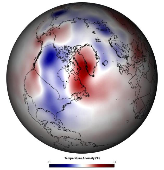
Graphic credit above: "
This composite map shows
temperature anomalies for periods in the historical record (from
1950-2009) when El Niño and the negative phase of the Arctic
Oscillation coincided. Note that this historical composite closely
matches temperature anomalies observed this winter." (NOAA image
by Ned Gardiner, Climate Program Office, and Michelle L’Heureux,
Climate Prediction Center, using data based on NCEP/NCAR Reanalysis
with a 1971-2000 climatology.)
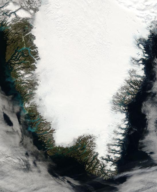
Why Greenland's Melting Could Be The Biggest Climate Disaster Of All. Here's a snippet from
Mother Jones: "...
As
an expert on Greenland who has traveled 23 times to the massive, mile
thick northern ice sheet, Box has shown an uncanny ability to predict
major melts and breakoffs of Manhattan-sized ice chunks. A few years
back, he foretold the release of a "4x Manhattans" piece of ice from
Greenland's Petermann Glacier, one so big that once afloat it was dubbed
an "ice island." In a scientific paper
published in February of 2012, Box further predicted "100 % melt area
over the ice sheet" within another decade of global warming. As it
happened, the ice sheet's surface almost completely melted just a month later in July—an event that, in Box's words, "signals the beginning of the end for the ice sheet."...


No comments:
Post a Comment