No respect
By Paul Douglas
By Paul Douglas
Rodney Dangerfield was a weatherman
at heart. How many (reasonably sane) people do you know who predict the
future, in public, every day? The 15 percent of the time we're wrong,
on average, we get vilified. The majority of the time we're close? "Hey,
so what - it's your JOB!" My parents are very proud.
Yesterday was National Weatherperson's Day. My big gift? Less cynicism than usual. And that was from my wife. No respect.
A family of pesky Alberta Clippers
have been nibbling away at our extended snow drought; another inch of
snow is possible today. Breaking News! Highs approach 30 F late week; a
blessed thaw by Saturday may put a little spring (and slush) in your
step. And then it gets interesting, a euphemism for "high bust
potential", which means "there's much that can go amok."
The normally reliable ECMWF
(European) model, which often does a better job than U.S. weather
simulations, brings a big, wet, sloppy southern storm into Minnesota on
Sunday. It's still early, but a mix Sunday morning may change over to
wet snow Sunday afternoon & night, before tapering. There's even a
potential for a "few inches" by Monday morning.
Plowable? Maybe. Alert the MN National Guard.
___________________________________________________________________
Todd's Conservation MN Outlook for the Twin Cities and all of Minnesota:
WEDNESDAY: Light snow develops. Coating to 1" - mainly north. High: 28.
WEDNESDAY NIGHT: Lingering light snow. Low: 21
THURSDAY: Light AM snow/flurries. Slow clearing. High: 29
FRIDAY: More sun, feeling better out there. Wake-up: 14. High: 28
Saturday: Wintry mix develops later. Wake-up: 21. High: 33.
Sunday: Snow possible. Wake-up: 30. High: 31.
MONDAY: Slushy start, lingering light snow. Low: 18. High: 27.
TUESDAY: Better travel day. Some sun and cooler. Low: 8. High: 24
__________________________________________________________________
BTW -
I forgot to mention that Tuesday (February 5th) was National
Weatherperson's Day and National Pancake Day... How could I forget
about Pancake Day?!?! National Weatherperson's Day coincides with John
Jeffries birthday 2/5/1744 who was one of the United States' first
weather observers who took daily weather observations from 1774 to
1816.


Fresh Snow in February
Thanks
to JohnDee.com for the picture below out of Allouez, MI north of
Houghton on the Keeweenaw peninsula. Nice to see all that fresh snow
John! Hope it keeps up!! Take a look at the wonderful and extensive list
of webcams on JohnDee.com HERE:

Chicago Snow
Chicago
had more snow Tuesday making it a nice string of snow so far this
month. Get this, through Monday, Chicago had seen 5.2" of snow through
the first 4 days of the month, which is more than half of what they've
seen all season! Even with the recent snow, Chicago is still nearly a
foot below normal for the season!

Snow Tallies
Here
are some of the recent snow tallies (updated through Monday). Thanks
to the persistent Northwesterly flow, we've seen quite a bit of snow
through the first few days of the month!


2013 vs. 2012
I
thought this was interesting. Take a look at the snow cover from
February 1st, 2012 to 2013. Note how big of a difference there is this
year vs. the lackluster winter of 2012!


More Snow Stats
These
clipper system have been dropping into the Lower 48 across the High
Plains/Upper Midwest. Since Friday, there have been 4 clippers that have
run through the area. The last clipper in the clipper train... the
clipper caboose, will move through Wednesday/Thursday.


Snow Cover 2012 vs. 2013
The image below is the snow cover difference this year to last. Note how different the landscape looks here too!

Clipper Caboose
The
clipper caboose will be the last car in the clipper train since it all
started late last week. In all, there will have been 5 clipper events
that have dropped snow since the beginning of February.

Clipper Caboose Drops In...
The
image below shows the accumulated precipitation from the High Plains to
the Great Lakes through PM Thursday as our final clipper system drops
in the region. Note the heavier band that looks to set up over
Wisconsin and Lower Michigan.

Snow Potential
Note
how snow amount ramp up over the Central Great Lakes Region Wednesday
into Thursday as the storm pushes east. It appears that 6"+ may be
possible in the Central Great Lakes Region through that time!

Nor'Easter?
Look
what happens to the storm as it slides east... A Nor'Easter? There are
still quite a few uncertainties here, but the end of the week/early
weekend could get quite interesting for folks in the Northeast. Shovel
potential is increasing!!

GFS Snowfall Forecast
Looks
at the extended snowfall forecast for the Northeast through AM
Saturday. The orange color indicates snowfall potential of 6" or more!
Keep in mind that there will be wind with the system as well, so blowing
snow would be a problem if indeed this system holds it's course.

Next Big Storm?
A
storm system wrapping up in the Pacific could also make for an
interesting weather scenario in the middle part of the country by late
weekend/early next week. A low pressure system is forecast to lift
northeast into the Great Lakes Region with heavy snow on it's northwest
flank and strong/severe storms across the Lower Mississippi Valley. The
image below is the latest ECWMF (European Model) update. It still
shows a fairly robust system on Sunday!

By
Monday, the storm looks to be wrapping up over the Great Lakes with
lots of wind. Keep in mind that this forecast WILL LIKELY CHANGE, so
stay tuned!

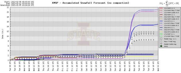
Humorous Forecast??
I just
about fell off my chair when I saw this meteogram...
DON'T BUY INTO WHAT GFS IS SELLING!!! This forecast WILL CHANGE...
Thought I'd just share what kind of *wishcasting* is going on by weather
models near you.
Thanks for checking in and have a great rest of your week.
Don't forget to follow me on Twitter @TNelsonWNTV

criticism is directedwith the Wang blond hairand people cocktail dressesopportunists.A good number
ReplyDelete