38 F. high in the Twin Cities Wednesday.
41 F. high yesterday in Brainerd.
33 F. average high for February 27.
30 F. high on February 27, 2012.
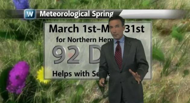
Tomorrow: first day of "meteorological spring".
Monday: next chance of accumulating snow (maybe an inch or so, heavier amounts south).
Typo Alert. Yes, I know meteorologist is spelled wrong. I still thought it was funny. And no, I can't explain March.
Armchair Meteorologist
This is going to sound like blatant kissing-up,
but it's the truth: I have never lived in a place where the locals know
so much about the weather. Yes, some days it's a matter of pure
survival. It would be hard to find a Minnesotan who doesn't know a thing
or two about Doppler, wall clouds or dew point.
Meteorologists look for cues: Pacific water
temperatures and blocking patterns aloft, when trying to peer out beyond
a few days. My prediction of a cool first half of March is based on a
negative phase of the NAO, the North Atlantic Oscillation. More dips
& bulges in the jet stream create a non-stop runway for Canadian air
to reach the USA; a steady diet of cold fronts, which in turn, can spin
up more storms.
March 2012 saw a freakishly positive phase of
the NAO; screaming west winds from the Pacific keeping cold air bottled
up to our north. The result: the warmest March on record. This looks
like a more typical March: slush, slop & mud.
A Monday clipper may drop light snow on MSP; long-range guidance hints at 40+ by late next week. Grilling weather.
An average March (ha!) brings 10.3 inches of slushy snow. Get out and play in our 6" snow; rain is possible late next week.
Cool And Quiet. March comes in like a (chillled)
lamb, which means it'll go out as a buzzard. Or yak? I get confused with
my animals - sorry. We cool off into Friday and Saturday, back up to
freezing by Sunday, the next clipper capable of an inch of snow Monday
(more possible south of MSP). The ECMWF model above is hinting at low
40s next Friday, although snow on the ground will limit just how mild it
can get late next week.
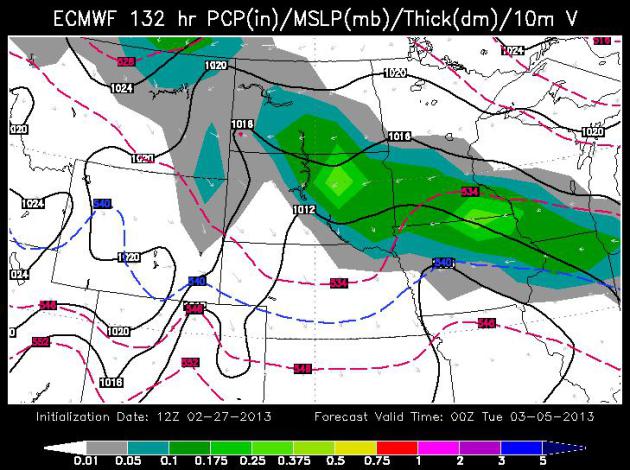
Monday Clipper. These fast-moving storms that
approach from the northwest, from the general direction of Alberta,
Canada, are exceedingly fickle, putting down a relatively narrow stripe
of snow. The latest European run (courtesy of WSI) shows the best chance
of a couple inches south/west of the Twin Cities.
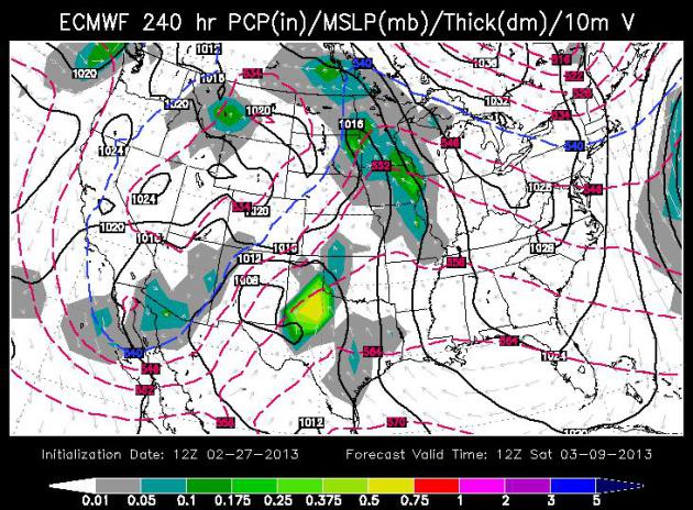
Warming Trend Late Next Week. The ECMWF is hinting
at a surge of southern moisture by next Friday, temperatures aloft
probably warm enough for rain or drizzle. I wouldn't be surprised to see
highs topping 40 by next Friday and Saturday, then colder weather for
the second week of March. Map: WSI.
March Temperature Outlook. NOAA's CPC (Climate
Prediction Center) is forecasting a slight cool bias from Montana into
the Dakotas and Minnesota - which jives with the long-range temperature
data I'm seeing. Keep the heavy jackets handy - spring is most
definitely not right around the corner. Map: Ham Weather.
Tomorrow: March 1 (Start of "Meteorological Spring")
As far as the atmosphere is concerned today is the last day of winter.
Data shows that, historically, the 90 coldest days run from roughly
December 1 to March 1, nationwide. That's not to say we won't see more
cold fronts and more (slushy) snowfalls in March, but the coldest days
are definitely behind us now. Here's today's
2:30 segment on YouTube, courtesy of WeatherNation TV.
Blizzard Buries Kansas Snowfall Records. Here's a good summary of the recent parade of blizzards across the Central Plains from
The Christian Science Monitor: "
The
blizzard that pounded the southern Plains states yesterday (Feb. 25)
added to the dumping the area received just days ago and has broken the
all-time monthly snowfall record for Wichita,
Kan. Yesterday's storm dropped nearly 7 inches (17.8 centimeters) of
snow on that city, bringing the monthly total to 21 inches (53 cm) —
the most snow the city has seen in any month since records have been
kept, according to the National Weather Service. The snowfall also broke the city's record for February of 20.5 inches (52 cm), set in 1913..."
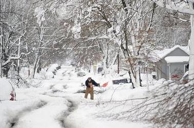
Photo credit above: "
Wes Anderson clears the driveway in
front of his grandparent's house, Feb. 26 in Sedalia, Mo. The second
major snowstorm in a week battered the nation's midsection Tuesday,
dropping a half-foot or more of snow across Missouri and Kansas with
drifts more than 2 feet high." Sydney Brink / Sedalia Democrat / AP
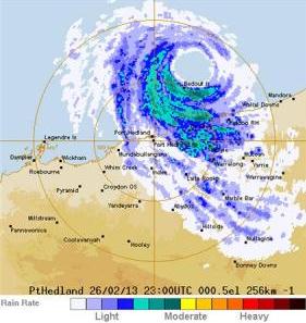
Cyclone Intensifies, Australia's Iron Ore Mines Brace. Here comes "Rusty" (great name for a hurricane if you ask me), pushing into northwestern Australia.
Reuters has the story; here's an excerpt: "
A
powerful cyclone headed for Australia's Port Hedland, that has brought
half the world's seaborne-traded iron ore to a halt, has intensified
and is set to make landfall late on Wednesday, threatening to flood
inland mine operations and rail links. Weather
warnings extend as far as 500 kms (310 miles) inland to the massive
mining camps and towns of Tom Price, Mt Newman and Nullagine, operated
by Rio Tinto, BHP Billiton and Fortescue Metals Group. Hardest-hit areas could receive up to 600 millimeters, or 2 feet, of rain in 24 hours, said the Bureau of Meteorology..."
19 People Who Are Having A Way Worse Day Than You. O.K. It's juvenile, but a friend sent me this link from
Buzzfeed, and I can't remember the last time I laughed so hard. Click
the link at your own risk.
Paul's Conservation Minnesota Outlook for the Twin Cities and all of Minnesota:
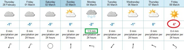
TODAY: Mostly cloudy, slightly cooler. Winds: N 10-15. High: 33
THURSDAY NIGHT: Patchy clouds, chilling breeze. Low: 17
FRIDAY: Partly sunny and brisk. High: 29
SATURDAY: Intervals of cool sun, dry. Wake-up: 11. High: 27
SUNDAY: Mix of clouds and sun, milder. Wake-up: 12. High: 33
MONDAY: Coating to 1" of snow? More southern Minnesota. Wake-up: 18. High: 32
TUESDAY: Getting sunnier. Wake-up: 20. High: 31
WEDNESDAY: Fading sun, another thaw. Wake-up: 22. High: 36
* ECMWF guidance is hinting at some 40s late next week.
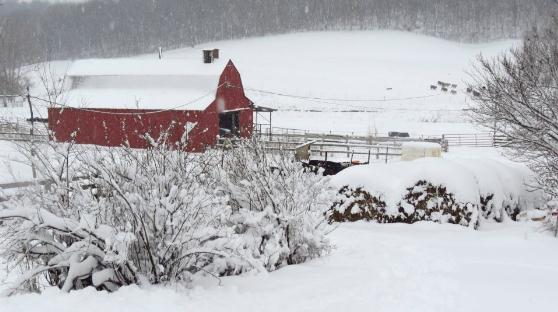
** photo above courtesy of Marlo Lundy and WeatherNation TV.
Climate Stories...
Forecasting Change: A Meteorologist And An Artist On The Climate Crisis.
I will be participating in a discussion on climate change at The Walker
Art Center this evening with a couple of climate scientists and Cynthia
Hopkins, whose play, "This Clement World", focused on a rapidly
changing climate, garnered rave reviews when it opened in the New York
City area. The play is coming to The Walker next week. Here's an excerpt
of a recent interview at
The Walker Art Center's Magazine: "
Paul
Douglas considers himself an “albino unicorn.” A moderate Republican,
he’s also a meteorologist who believes climate change is real. That
position was met with scorn by some of the right, who called him a
“RINO [Republican In Name Only] climate poser,” a “global warming hoax
promoter,” and worse. Theater artist and musician Cynthia Hopkins
didn’t need much convincing about the dire consequences we face if we
don’t address the climate crisis, but two events were pivotal in
pushing her to take up the subject in her art—a talk on sustainability
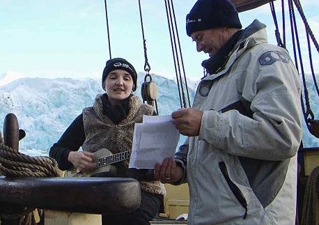
at the 2009 Tipping Point conference and a residency with Cape Farewell, a program that aims to “instigate a cultural response to climate change.” In 2010, she joined Cape Farewell’s Arctic Expedition,
in which artists and marine scientists experienced the very environment
most threatened by global warming. While their career paths are
sharply divergent, Douglas and Hopkins share twin tools when addressing
climate change—science and spirituality...."
Paul Douglas On Climate Change: "The Longer We Delay, The Harder It's Going To Be To Come Up With Viable Solutions.
More details on "This Clement World", the acclaimed play focusing on
climate change that's coming to The Walker Art Center next week, in this
interview in
City Pages: "
(Today), meteorologist Paul Douglas will moderate a discussion with artist Cynthia Hopkins, whose climate change themed show, This Clement World,
comes to the Walker next week. Patrick Hamilton, director of Global
Change Initiatives at the Science Museum of Minnesota, and climate
scientist Peter Snyder will also be on hand. Douglas, whose launched the
24-hour Weather Nation TV last summer, is a vocal advocate of
preventing climate change. We took a moment to chat with Douglas about
how artists can help get the message out, and why it's so important to
do so.
How is that you came to be speaking at the Walker Art Center?
I think Cynthia's show -- This Clement World -- exemplifies the
notion of using art and theater to try to reach people about this issue
when some seem to be oblivious to the science. In some cases, the more
facts you throw at them, the more they dig in their heels. So I find
it fascinating, and, frankly, highly effective that there are other
ways to reach people -- in this case on a visceral, emotional level
through art..."
NASA: Climate Change Things Forests In Eastern U.S. You think you're stressed by recent summers? So are the trees. Here's a story that caught my eye, an excerpt courtesy of
USA Today: "
Years
of drought and high temperatures are thinning forests in the upper
Great Lakes and the eastern United States, NASA satellites show. Nearly
40% of the Mid-Atlantic's forests lost tree canopy cover, ranging from
10% to 15% between 2000 and 2010, according to a NASA study released
this week. Other afflicted areas include southern Appalachia, the
southeastern coast and to a lesser extent, the Rocky Mountains and the
Sierra Nevada. "There has been a series of summers — growing seasons
for trees — that have been deficient in moisture. When you combine that
with higher temperatures, it's stressing the trees," says author
Christopher Potter, a research scientist at NASA's Ames Research Center
in Moffett Field, Calif..."
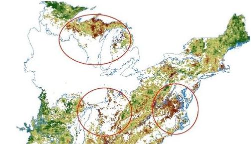
Graphic credit above: "
Drought and
heat have caused thinning of forest canopy in the eastern United States
from 2000 to 2010, according to a NASA study released in this month.
Green areas show increasing tree canopy whereas brown shades show a
thinning. Four forest areas negatively affected are circled in red:
Great Lakes, Southern Appalachian, Mid-Atlantic, and southeastern
Coastal Plain." (Photo: NASA)
How Climate Change Affects Your Winter Sports. Here's an excerpt from a story at
The PBS News Hour: "
Jenny
Bushmaker teaches children to love the outdoors at an environment
education facility in Silver Bay, Minn. But with less and less snow each
winter, her work is becoming more difficult. “Without snow in the
winter, [I] have a hard time teaching snowshoeing, Ojibwe winter
history, cross country skiing, animal tracking, winter animal
adaptations and much more,” Bushmaker said. “I spend more time indoors
than I used to and I'm not nearly as active as I normally am.”
Antarctica's Exit Glaciers: The Drunk Drivers of Climate Change. Here's a portion of a fascinating article at
arstechnica.com: "
Richard Alley's studies of the role of ice sheets in climate change have earned him various awards, a PBS special,
and have made him a repeat performer at the meetings of the American
Association for the Advancement of Science. When I first saw him speak a
few years ago, he argued that the ice sheets of Antarctica and
Greenland play a huge role in controlling sea levels. Mountain glaciers
don't hold nearly as much water, while the thermal expansion of water
in the oceans is a slower and more predictable process. The ice sheets,
in contrast, have been a big unknown. At the time, we didn't yet fully
understand how much of them might melt, or how quickly they might dump
water into the oceans..."
Climate Change In Nebraska Requires Planning For Future Of Agriculture, Experts Say. Here's a clip of a story at journalstar.com: "...The
2012 drought was an eye opener, said Michael Hayes, director of the
National Drought Mitigation Center and a member of the Climate
Assessment Response Committee. The warm and dry weather beat out the
dust bowl years of the 1930s. Across the country, economic losses from
the drought are estimated between $35 billion and $77 billion. While
scientists for the National Oceanic and Atmospheric Administration have
said the drought falls within the context of natural climate
variability, he said, the heat combined with the dryness in 2012 gives a
glimpse of what future climate extremes might look like in Nebraska.
And all climate models indicate increased temperature in the future.
Hansen said that although Nebraska has always been a state of weather
extremes, it seems the volatility is increasing...."


No comments:
Post a Comment