By Paul Douglas
In a day and age when 2-3 inches of snow has become "Breaking News!" can you imagine what a forecast of 2 to 3 FEET would bring? TV anchor's heads might spontaneously combust, grandmothers rioting in front of Cub, a run on SUVs, chainsaws & emergency generators? Yes, the Halloween Superstorm of 1991 comes to mind.
New England is bracing for an historic, crippling blizzard. New York City will pick up a foot, 20 to 30 inches for Boston, where 40-50 mph winds may carve out RV-size drifts. Oh, to be in Boston right now.
Why does the east coast get clobbered more than we do? Location. Access to a fresh supply of moisture off the Atlantic. For us to get heavy snow winds near the surface need to blow from the northeast (steady supply of cold air), while winds aloft howl from the southwest, pulling in moisture from the Gulf. Too much cold air pushes the storm south - too much southerly flow tips precipitation over to a mix or rain.
No weather worries today or Saturday, but a southern storm pushes a mix into town Sunday, changing to all snow Sunday PM. A few inches may fall; a plowable snow for central and western Minnesota. But it'll be a pale imitation of the Northeast Blizzard.
_________________________________________________________________________
Todd's CONSERVATION Outlook for the Twin Cities and all of Minnesota:
FRIDAY: More sun, feeling better out there. High: 28
FRIDAY NIGHT: Partly cloudy, quiet. Low: 18
Saturday: Clouds thicken through the day. Wintry mix overnight. High: 35.
Sunday: Rain/snow/freezing rain mix. A few inches possible late? Wake-up: 28. High: 33.
MONDAY: Scattered snow showers. Low: 26. High: 29.
TUESDAY: Better travel day. Intervals of sun. Low: 11. High: 25.
WEDNESDAY: Sun and cloud mix. Low: 14. High: 29.
THURSDAY: Next clipper arrives. Light snow. Low: 18. High: 28.
____________________________________________________________________________

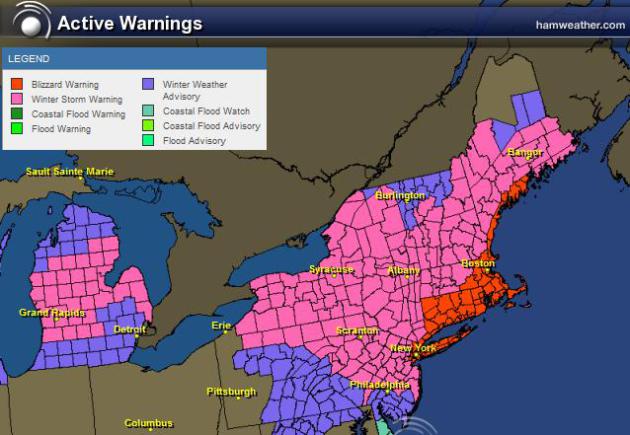
* POTENTIAL HISTORIC WINTER STORM AND BLIZZARD TO IMPACT MUCH OF SOUTHERN NEW ENGLAND FRI INTO SAT
Those are the words from the National Weather Service out of Boston, MA... Read more below.
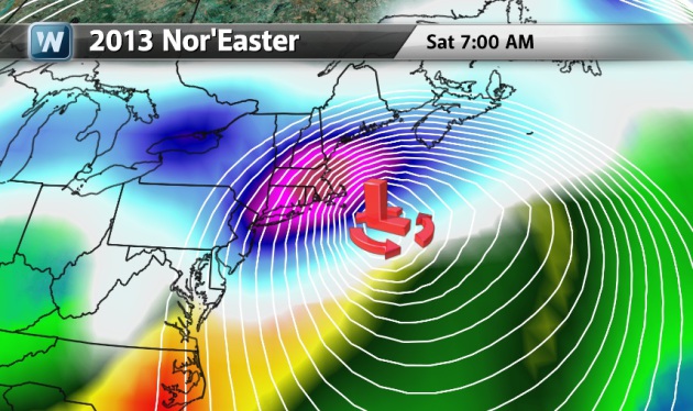
* 1 TO 2 FEET OF SNOW POSSIBLE FOR MUCH OF SOUTHERN NEW ENGLAND EXCEPT AREAS NEAR THE SOUTH COAST WHERE THERE MAY BE SOME MIXING. THE MODELS HAVE COME INTO VERY GOOD AGREEMENT ON A POTENTIALLY HISTORIC WINTER STORM AND A POSSIBLE BLIZZARD THAT WILL IMPACT MUCH OF SOUTHERN NEW ENGLAND. WE ARE CONFIDENT THAT MUCH OF THE REGION WILL RECEIVE 1 TO 2 FEET OF SNOW. STILL TOUGH TO PINPOINT WHERE THE BEST CHANCE FOR THE HIGHER AMOUNTS WILL BE...BUT CLIMATOLOGY FAVORS THE I-95 CORRIDOR. WE ALSO EXPECT A MID LEVEL DEFORMATION BAND THAT WILL LEAD TO LOCALIZED HIGHER AMOUNTS ACROSS THE INTERIOR. THE BULK OF THE STORM APPEARS TO BE IN THE FRIDAY NIGHT/SATURDAY MORNING TIME FRAME.
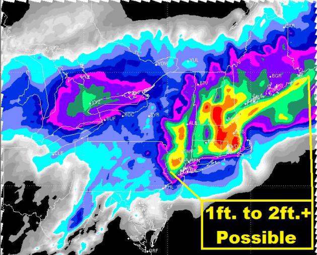
Amazing Snow Total Potential!
According to the RPM model... there will be a HUGE swath of 1 to 2 feet or more across parts of the Northeast!
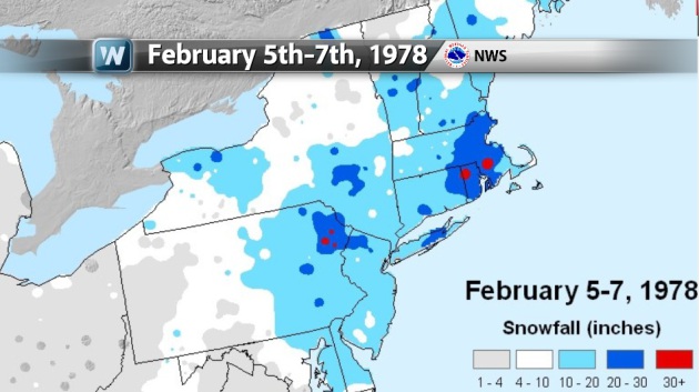
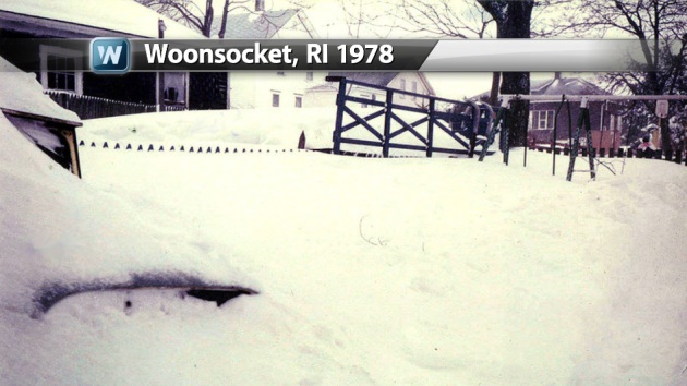
A Storm of Historic Proportions... 1978
Folks in the Northeast are no strangers to massive winter storms at this time of the year. February 5th-7th, 1978 there was a massive snow storm that dumped 20" to 30" + and crippled many of the BIG cities.
A Storm of Historic Proportions... 2013?
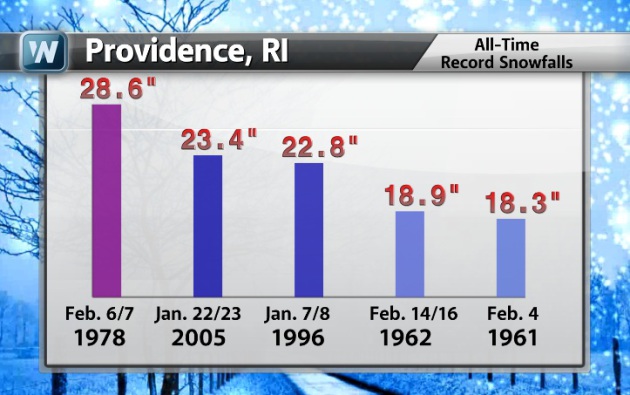
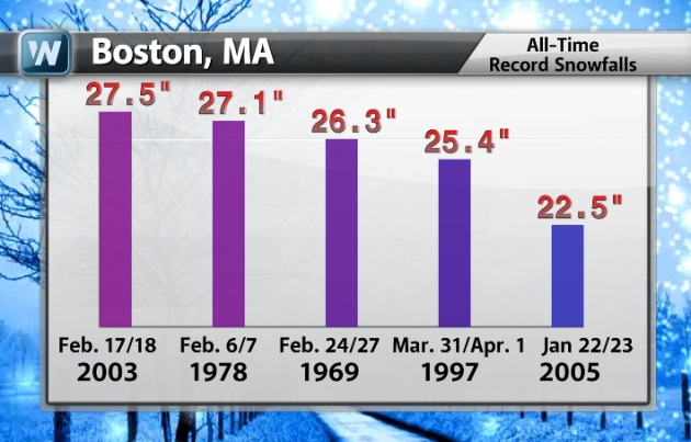
This storm definitely has the potential to dump record snow amounts in quite a few areas. Here are the top 5 storm totals for Providence, RI and Boston, MA. Interestingly, the February 5th-7th, 1978 storm ranks as the all-time greatest snow storm in Providence, RI at 28.6". Boston, MA had it's 2nd largest snow storm during that storm at 27.1". This storm certainly has the potential to meet OR exceed some of these top 5 tallies!
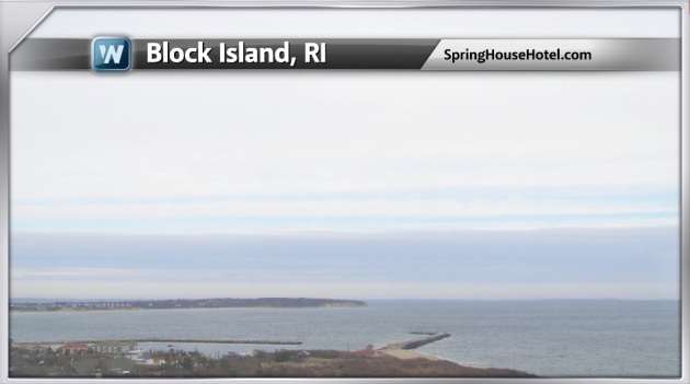
Proverbial "Calm Before the Storm"
I thought it would be interesting to take a look at these webcam midday Thursday and compare them to what it'll look like from midday Friday. The landscape will look A LOT different... Stay tuned! Keep in mind that both locations below could experience BLIZZARD conditions during the storm.
Block Island, RI
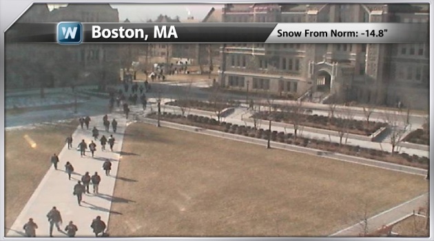
Boston College
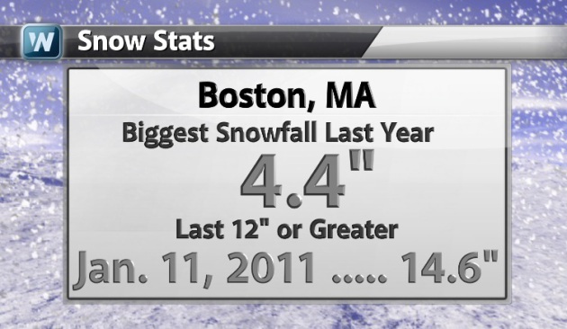
Boston Snow Stats...
Big snow has eluded the Boston, MA region over the last couple of winters. In fact, the last time we've seen a 12" snow storm was back in 2011. January 11th that had 14.6" !! By the way, the biggest snow event last winter was a whopping 4.4"
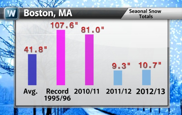
Boston Snow Stats Continued...
Here are some other Boston snow stats. Note the measly 9.3" seasonal snow total last winter!
Significant Snow Potential...
This is what meteorologists are juggling with... Take a look at how varied these forecasts are.
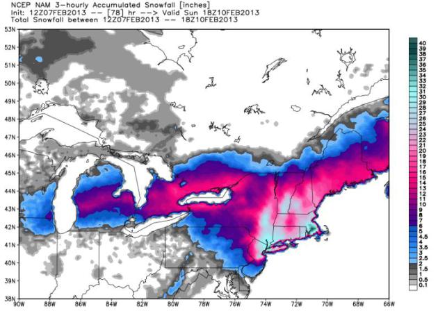
12z NAM
This might be a little much, but according to the 12z NAM 1 to 2 feet or more of snow is possible.
12z GFS
Not quite as crazy as the model below, but still close to 1 foot or more.
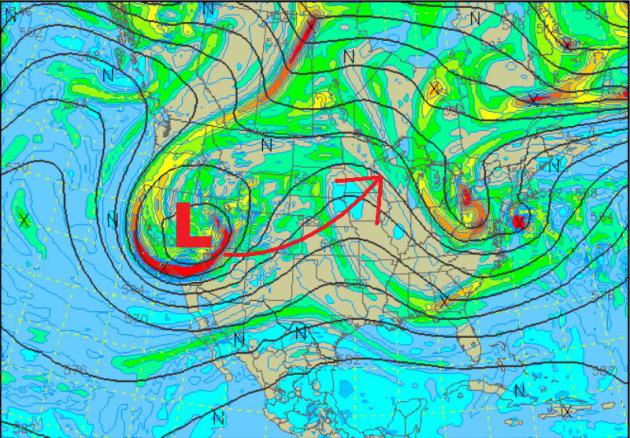
Another Storm on the Horizon
We're watching yet another storm for the weekend, which is expected to bring accumulating snow to the Upper Midwest through early next week.
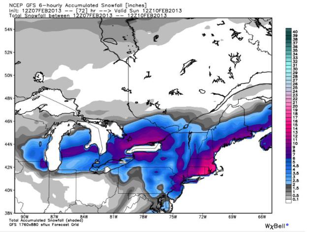
Weekend Storm
This is the storm progged by Sunday. This storm will have the capability of heavy snow across the Upper Midwest and strong/severe storms across the Lower Mississippi Valley.
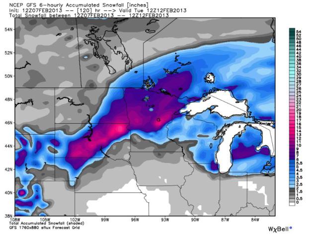
Snowy Scenario
According to the GFS, the heaviest snow will fall from the eastern Dakotas to northern Minnesota.
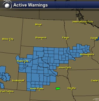
Winter Winter Headlines...
The
National Weather Service has issued winter weather headlines in advance
of the said system. More updates to come... stay tuned!
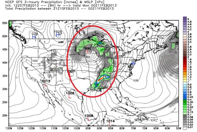
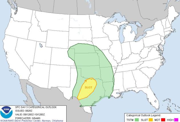
Stormy Scenario
This storm system will also have the capability of producing strong to severe thunderstorms across the south Saturday and possibly Sunday. The Storm Prediction Center has issued a SLIGHT RISK of severe weather for parts of Texas on Sunday. Stay tuned for more.
Thanks for checking in, have a great weekend ahead!
Don't forget to follow me on Twitter @TNelsonWNTV

anger, the beauty of the burning flame.winter boots women
ReplyDeleteHe is completely tragic role. Origin can not choose, the position of inferiority, sincere love is