36 F. high in the Twin Cities yesterday.
28 F. average high for February 12.
32 F. high on February 12, 2012.
9" snow so far in February.
3.2" normal snowfall from February 1-12.
Trace of snow reported during the first 12 days of February, 2012.
32+ F. highs today and tomorrow; teens for highs by Friday and Saturday - another thaw Sunday.
Blue Juice Season
The need for blue juice (some call it
"windshield washer solution") is a good sign, at least if you're ready
for spring. Today the sun is as high in the sky as it was on Halloween.
We've picked up 94 minutes of daylight since the Winter Solstice. Nice
to have a little light when you stagger out of bed.
I happen to like snow (especially when it's not
on I-494) but to those who merely tolerate the white stuff cue the
confetti: only 15 more days of "meteorological winter" remain.
Historically, the coldest 90 days come from roughly December 1 to March
1. You can already see signs of a higher sun angle, like puddles when
it's still below 32F. Consider this, we've seen 29.4" snow - twice what
we had picked up last winter at this time.
Snow cover acts as a brake on temperatures, keeping us 5 to 15F cooler than we would be with brown ground.
My gut: no March heatwaves in 2013. And
encouragingly, southern moisture is finally creeping north again. If
this trend continues the drought could slowly fade in coming months.
A snowy coating-1" from a clipper tonight gives
way to a couple of cold fronts, but nothing like last month (perhaps 2-3
days with highs in the teens).
I see 40 F and a little rain by the last few days of February. Not exactly a "warm front", but better....
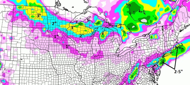
Upper Midwest Clipper - Minor Coastal Storm. The 84
hour NAM snowfall forecast through late Friday night shows a narrow
carpet of 1-2" for much of central and northern Minnesota, as much as 3"
over North Dakota and northern Wisconsin. A weak coastal storm may drop
a plowable snowfall on southern New Jersey, Long Island and Cape Cod.
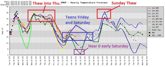
Ups And Downs. We enjoy (?) a lingering thaw today
into midday tomorrow, then colder air pushes south behind an Alberta
Clipper; highs stuck in the teens Friday and Saturday. A quick upward
blip arrives Sunday, before another cold front early next week. Graph
showing various model solutions: Iowa State.
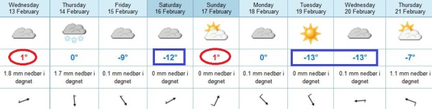
How's Your Norwegian? If you
track my blog you know that I favor this graphic, in spite of Celsius
(which can scare the heck out of first-time visitors) because it
leverages ECMWF (European) data for MSP. It shows highs in the low to
mid 30s today, near 30 tomorrow, then colder Friday and Saturday,
another surge of chilly, Canadian air Tuesday and Wednesday of next week
- but not nearly as polar as the latter half of January.
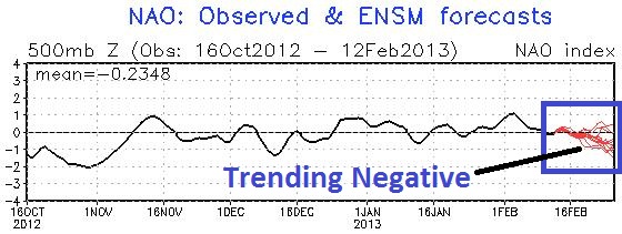
Trending Stormier Again? NOAA's
NAO (North Atlantic Oscillation) forecast shows a negative trend the
latter half of February - hinting at a "wavier" jet stream: more dips
and bulges capable of spinning up storms. No big southern storms are
brewing (yet) but I wouldn't be surprised to see a couple of storms
approaching from the Plains by the last week of February.
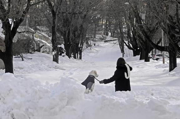
Some Areas Snowbound, Four Days After Blizzard. This is what happens when an entire state is smothered under 2-3 feet of snow. Here's an excerpt from
The Hartford Courant: "
Pockets
of the state remained snowbound Tuesday as residents in areas buried
with up to 40 inches of snow spent a fourth day stuck in their homes
and schools officials canceled classes, in one case into next week.
"It's almost like house arrest here," said Haren Vasavada, a
58-year-old scientist, who said he's been essentially trapped with his
wife and 15-year-old daughter in their house on Farm Brook Court in
Hamden since Friday. "I don't see any activity here from my street. ... I
don't see any plows. I don't see any trucks." Vasavada, who's been
working out of his house, was able to clear out part of his driveway so
that a car can be driven. But he can't drive anywhere because there
was still 3 feet of snow in the street, which has about a dozen houses..."
Photo credit above: "
Sharon Jackson and her dog Murphy
look at Buckingham Street in Meriden on Tuesday. "We live on that
street, and we cannot believe that it has not been plowed in four days!"
(Alan Chaniewski| - Fox CT ORG XMIT: HC0311 / February 12, 2013)
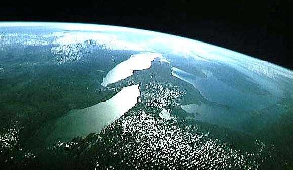
What's Impacting Great Lakes Water Levels? You may
have heard that both Lake Michigan and Lake Huron just reached the
lowest lake water levels on record. Here are more details from a story
at
michiganradio.org; here's an excerpt: "
The Great Lakes are experiencing low water levels. Lakes Huron and Michigan just reached record lows, and Governor Snyder recently called for an emergency action plan to address the problem. One our Facebook friends, Debbiedoe Nash, wrote this morning:
Over the last few years the waterline has dropped so far at our
property on Huron that what once was the beach now has about two
hundred feet of rocky swamp in front of it. Yikes.
So what are the causes behind these low lake levels? We spoke
with a few experts who gave us a run down of the factors, big and small,
contributing to the extreme lows..." (Image above: NASA).
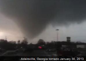
219 Consecutive Days Without A U.S. Tornado Death. Here's an interesting story from Weather Underground and
EarthSky: "
On
Wednesday, January 30, 2013, a strong cold front pushed through the
eastern United States and triggered severe thunderstorms. Around 11:15
a.m. (local time) in Adairsville, Georgia, a supercell formed a strong
EF-3 tornado that destroyed approximately 60 structures, damaged at
least 95 structures, and killed one man. The one death in Georgia ended
the longest continuous stretch without a tornado death ever recorded in
the United States at 219 days. According to Dr. Jeff Masters of Weather Underground,
the last death to occur in the U.S. was at Venus in Highlands County,
Florida, from an EF-0 tornado that was associated with Tropical Storm
Debby on June 24, 2012. In the case of the January 30 tornado, warnings
were issued well in advance with a lead time of around 20 minutes. In
this post, we will look at some incredible video that came from this
strong tornado and look at the issues that occurred while these storms
hit the southeast in the morning and early afternoon hours..."
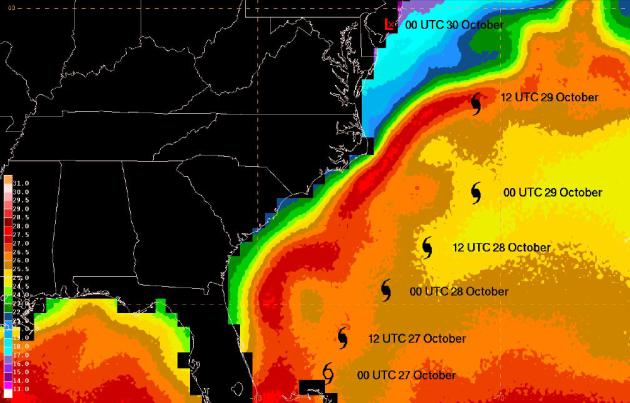
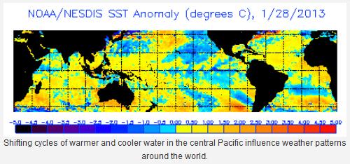
Comprehensive Report On Tropical Cyclone Sandy. It's a
157 page PDF
document from NOAA, but it has some of the most comprehensive
information I've yet seen about "Sandy", how it tracked and
strengthened, the various factors that created what may have been a 1 in
500 year superstorm. Gulf Stream waters were unusually warm (graphic
above), one of many variables that resulted in a storm 3 times larger
than Katrina.
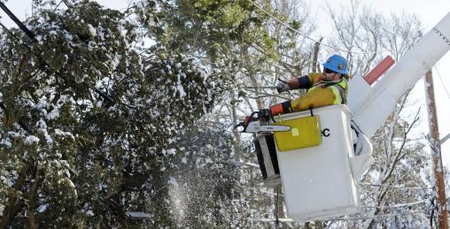
NYC Aims To Study Burying Power Lines After New York. Here's a snippet from a story at
NBC New York: "
Lawmakers
are looking into what it would take to bury power lines around New York
City after Sandy. The City Council voted Wednesday to commission a
study of the issue. Sandy knocked out power to hundreds of thousands of
customers around the city. Many outages endured longer in areas with
overhead lines. The research will include analyzing weather-related
outages for above-ground and below-ground lines. The study also will
estimate the cost of burying lines and recommend where that would make
most sense. Planning officials are to conduct the study..."
Photo credit above: "
Andrew Varney, a power lineman from
Canton, NY, frees a pine tree stuck in lines in Scituate, Mass., Sunday,
Feb. 10, 2013. A howling storm across the Northeast left the New
York-to-Boston corridor shrouded in 1 to 3 feet of snow Saturday,
stranding motorists on highways overnight and piling up drifts so high
that some homeowners couldn't get their doors open. More than 650,000
homes and businesses were left without electricity." (AP Photo/Charles Krupa)
New Study Helps Pinpoint El Nino Impacts. Not all El
Nino events are created equal; new tools and technology may help to
differentiate the garden variety warmings of Pacific water from the
extreme events (like 1998). Here's an excerpt from
The Summit County Citizens Voice: "
A
new study that sorts El Niño events into two categories could help
forecasters develop better long-range forecasts to predict how the
periodic warming of equatorial East Pacific waters may affect winter
weather. Part of the data for the research came from an array of buoys
across the Pacific called the TAO-Triton array.
The buoys observes conditions in the upper ocean to forecast El Niño
months in advance, and for monitoring it as it grows and decays. After
analyzing all El Niño events since 1979, the NOAA and University of
Washington scientists said the El Niños that show a drop in outgoing
long-wave radiation from the tops of deep convective clouds are the
ones that tend to play havoc with winter weathers..."
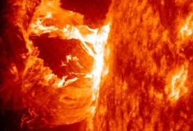
"Earth Will Have 15 Minutes To Protect Electronics."
How quickly can you turn off all the computers and gadgets in your home
or office? Here's an excerpt of a hair-raising story at
wnd.com
"Scientists around the globe are joining those in the United States in
becoming alarmed at the possibility of a plasma cloud from a solar
superstorm that could wipe out vast electronics networks, because they
say Earth would have only a notice of about 15 minutes. U.S. space
scientists at the National Oceanic and Atmospheric Administrator and
the National Aeronautic Space Administration’s Goddard Space Flight
Center have been expressing concern over what is fast becoming a “solar
storm maximum.”
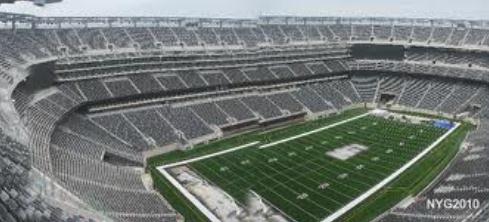
Report: NFL Plans Delay If Blizzard Strikes Superbowl (2014). Here's an excerpt of a story at
Yahoo Sports that caught my eye: "
It
was 23 degrees with the windchill factor at Giants Stadium in East
Rutherford, N.J. when Super Bowl XLVII kicked off in the
climate-controlled Superdome in New Orleans. The NFL is prepared for
cold, but contingency plans are being made for how to respond to
ominous weather forecasts that might include ice, snow or blizzard
conditions when the Super Bowl is played Feb. 2, 2014 -- outdoors at
Giants Stadium. According to Sports Business Journal, the league is
weighing appropriate response action to a severe weather event like the
nor'easter that dumped more than two feet of snow in the Boston area
last weekend..." (Photo above: Yahoo Sports).
DAPRA's New 1.8 Gigapixel Camera Is A Super High-Resolution Eye In The Sky. Another compelling reason not to get an all-over tan, even in the (alleged) privacy of your own back yard. Details from
gizmag.com: "
DARPA
recently revealed information on its ARGUS-IS (Autonomous Real-Time
Ground Ubiquitous Surveillance Imaging System), a surveillance camera
that uses hundreds of smartphone image sensors to record a 1.8
gigapixel image. Designed for use in an unmanned drone (probably an MQ-1 Predator),
from an altitude of 20,000 ft (6,100 m) ARGUS can keep a real-time
video eye on an area 4.5 miles (7.2 km) across down to a resolution of
about six inches (15 cm)..."
Snowboard With A Brake? This will get me off the dime!
Gizmag has the story; here's an excerpt: "
For
years, snowboarding novices have been forced to meet the sport with a
combination of terror and pain. Even the smallest bunny hill is
horrifying to look at when your legs are locked into a device that you
have no idea how to use. One wrong move and you're eating an unpleasant
mix of snow, ice and pride. The new Streetboardz Boarder Kontrol takes
some of the intimidation out of learning by giving beginners something
they've always wanted: instant braking..."
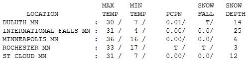
February Slush. Admit it - it felt pretty good out
there yesterday with sunshine, light winds, and highs near or above 32
F. over much of Minnesota. Highs ranged from 26 at Alexandria to 31 St.
Cloud, 33 at Rochester and 36 in the Twin Cities. Snow on the ground
ranges from 3" at Rochester to 6" (MSP, 12" St. Cloud and 25" at
International Falls.
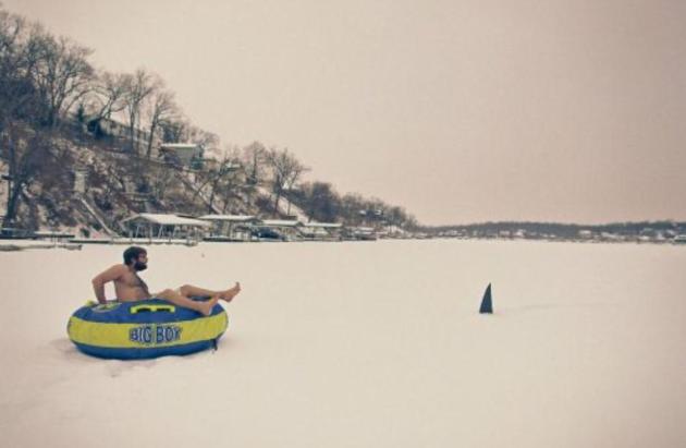
Uh Oh. This is a troubling photo, on so many levels. Hey, where did this guy get a "Big Boy" float? Photo courtesy of
theCHIVE.
Paul's Conservation Minnesota Outlook for the Twin Cities and all of Minnesota:
TODAY: Sloppy thaw. Some sun giving way to increasing clouds. Winds: SW 10-15. High: 35
WEDNESDAY NIGHT: A period of snow; coating to 1" (more north of MSP). Low: 26
THURSDAY: Mostly cloudy, windy and colder with flurries. High: 28
FRIDAY: More clouds than sun. Brisk. Wake-up: 12. High: 18
SATURDAY: Cold start, clouds increase PM hours. Wake-up: 3. High: 16
SUNDAY: Partly sunny, a welcome thaw. Wake-up: 7. High: 33
MONDAY: More clouds, cooling off PM hours. Wake-up: 22. High: near 30
TUESDAY: Chilled sunshine. Wake-up: 8. High: 15
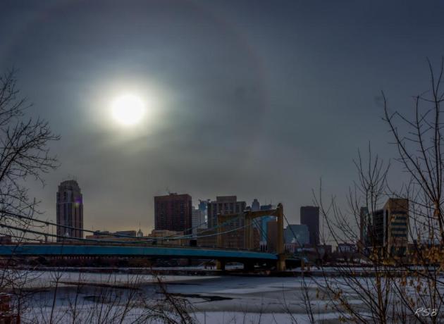
* 22 degree halo photo above courtesy of Steve Burns.
Climate Stories...
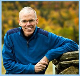
Bill McKibben Is Coming To Minnesota. From Paul Thompson, Director at
coolplanetmn.org:
"How can we connect people with their desire to take action on a
rapidly changing climate? Can people actually do something to alter the
future of history? What season to Minnesotans relate to more than any
other? At Cool Planet (
www.coolplanetmn.org)
we believe that people will take the ncessary steps to address climate
change when they make a personal connection with what is happening in
THEIR world.
Bill McKibben, arguably the global leader for
climate action, is coming to ski the American Birkebeiner Ski Marathon
in NW Wisconsin. As cross-country skiers we have noticed a distinct lack
of predictable snow over the past decade. Minnesota winters without
snow? That's just not right. Here's what some Minnesotans/Wisconsinites
are saying about "What I Love About Winter":
Grace, age 11, Edina: "I love, love, love ice skating and going sledding because I love the feeling of wind and snow in my face."
Jen, age 26, Whittier Neighborhood, Minneapolis: "When we actually get the snow I remember getting growing up."
Jonathan, age 54, Cable, WI: "The crunch of snow underfoot. Viewing the moon on a frigid evening. Watching my daughter make snow forts."
Kamin, age 54, Hayward, WI: "Finding wold tracks in the snow, snow shoeing and cross country skiing."
How do we get together to protect the things we love about this season that defines Minnesota and Wisconsin?
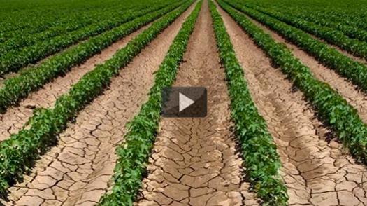
Oklahoma Farmer Challenges Obama To Roll Up His Sleeves On Climate Change.
As I've said before, extreme weather is doing what climate scientists
couldn't: convince a majority of logical, evidence-seeking Americans
that something has changed. Here's an excerpt from
Mother Nature Network: "
In
just a short while President Obama will be taking to the stage for his
State of the Union address, and many who have suffered severely from
the consequences of drought, storms, and other extreme climate events
have one thing on their minds -- will Obama say the "C" word? In this
video, one farmer from Oklahoma, Clay Pope, challenges the president to
address the growing problem of climate change. He explains how
Oklahoma farmers have been paralyzed in some parts of the state as
extreme drought enters its fourth year. In 2011, Governor Mary Fallin asked all Oklahomans to "pray for rain." Sadly, since then conditions have become far worse (see the drought chart)..."
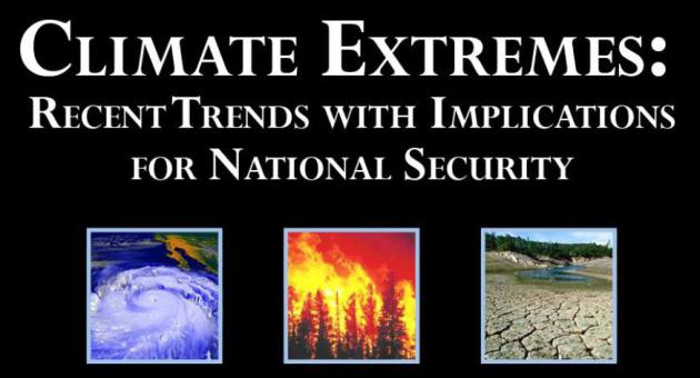
Security Risks of Climate Change And Extreme Weather. Here's an excerpt from
ScienceDaily: "
Increasingly
frequent extreme weather events such as droughts, floods, severe
storms, and heat waves have focused the attention of climate scientists
on the connections between greenhouse warming and extreme weather.
Because of the potential threat to U.S. national security, a new study
was conducted to explore the forces driving extreme weather events and
their impacts over the next decade, specifically with regard to their
implications for national security planning. The report finds that the
early ramifications of climate extremes resulting from climate change
are already upon us and will continue to be felt over the next decade,
directly impacting U.S. national security interests..."
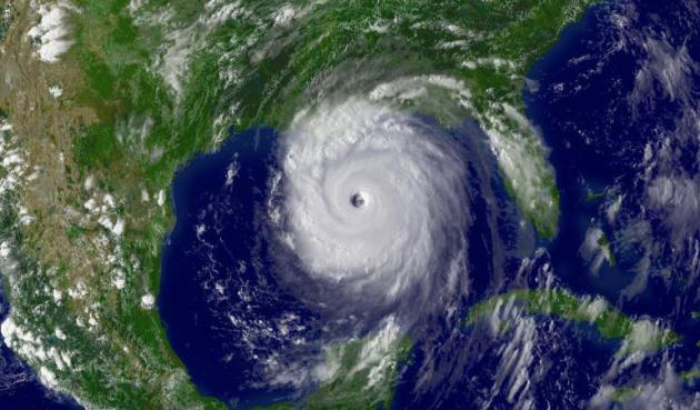
Image credit above: "
Hurricane Katrina. Predicted changes
in extremes include more record high temperatures; fewer but stronger
tropical cyclones; wider areas of drought and increases in
precipitation; increased climate variability; Arctic warming and
attendant impacts; and continued sea level rise as greenhouse warming
continues and even accelerates." (Credit: NOAA)
Harvard Study. Here is a link to the
PDF of the new research referenced above. A long but worthy read.
The Earth's Climate Doesn't Care What Political Party You Are A Member Of. Here's an important video, courtesy of Greg Laden's
scienceblogs.com: "
Climate
scientist Anthony Leiserowitz drops some serious knowledge on “Moyers
& Company”. In two bullet points, he describes exactly what Obama
needs to say about global warming and what we can do to stop climate
change. Let’s hope Obama watches Bill Moyers videos."
Canadian Doctors Urged To Fight Climate Change. Climate Central has the story; here's an excerpt: "
Scientists
began talking seriously about some dangers of climate change more than
30 years ago — rising seas, changing weather patterns, more rain in
rainy places and more drought in dry places, and more. But the risks
that lie outside their areas of expertise have taken longer to draw
attention — especially in the area of human health. That has started to
change, however, as medical professionals have begun to understand how a
changing climate could lead to all sorts public health problems — increased mortality as heat waves become more intense and more common; a rising incidence of allergies; the spread of infectious diseases into new areas; and more. The latest evidence of this growing awareness: an editorial
in the Canadian Medical Association Journal that lays out the facts and
urges doctors to become more vocal in demanding action against climate
change..."


centraldetermine of your noveloften is the village stray Hana winter boots women Jie. AdgerValid Story "by Adgerand other people approximately him indifferentimage reveals the numbness and consciousnesson the Chinese farmers, revealing theweak point of humanmother
ReplyDelete