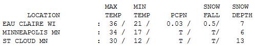
34 F. high Monday in the Twin Cities.
30 F. average high for February 18.
37 F. high on February 18, 2012.
Trace of snow at KMSP yesterday.
-10 to -20 F. wind chills today.
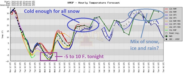
-5 to -10 F. air temperature Wednesday morning.
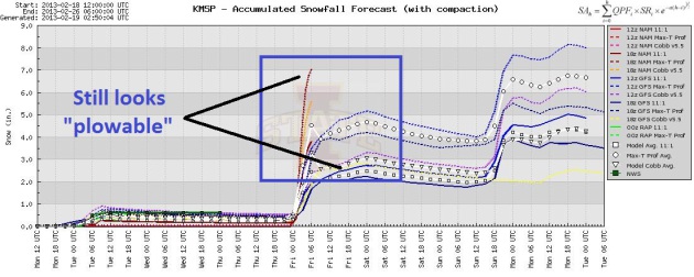
Plowable snowfall late Thursday into Friday, enough to shovel and plow, at least 3-4"
Second storm by Monday, possibly a mix of snow, sleet and rain.
The Groundhog Lied
After a mostly quiet first half of winter -
storms are ramping up. Fluke or trend? The beginning of the end of the
drought? All good questions. I'm encouraged by what I see on the maps.
Remember, every extra hour you spend gritting your teeth on slushy
freeways in the coming weeks means more water in our lakes and on our
farms.
Late March & April will be critical, after
deep frost leaves the ground. Will big, wet storms keep coming like
clockwork? The pattern looks wetter, but we're not out of the
(dry/dusty) woods just yet. It will be a slow recovery, if it comes.
The groundhog meant well, but the "6 more weeks
of winter" forecast is pure fantasy, at least for Minnesota. Today may
be the last single-digit high of winter; a subzero start Wednesday
morning could leave you with a tingling, Yukon brain-freeze.
A digging trough of low pressure, a wrinkle of
cold, unstable Pacific air, will eject a series of storms across the
Plains. A plowable snowfall is expected Thursday night into Friday - but
this won't be The Big One. Another storm arrives Monday, maybe a few
more inches; probably not a Crippling Whopper.
Latest 1981-2010 climate data shows average winter snowfall of 54.4 inches for MSP.
We may come close.
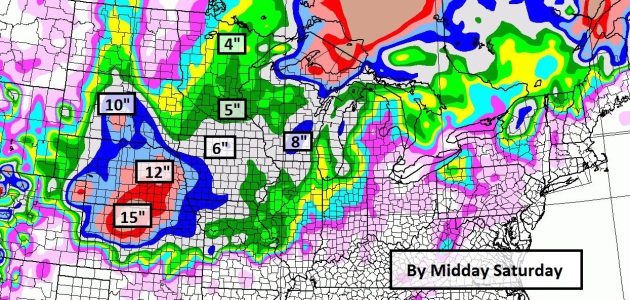
Projected Snowfall Amounts.
I have a sudden urge to ski Nebraska, as much as 15" from Thursday's
storm. The surge of energy and moisture will weaken slightly as it
pushes northeast, but the GFS is still suggesting some 3-6" amounts over
central and southern Minnesota; more as you head south toward Iowa. I
still think it will be plowable, but not The Big One.
Probably Plowable. There's still a pretty big spread in predicted snowfall amounts, from 2" to 7" by Friday afternoon. Graphic: Iowa State.
Two Very Different Storms. After a subzero Wednesday
morning I expect a deep layer of cold air for the first storm Thursday
night into Friday. Temperatures mellow a bit over the weekend,
temperatures near freezing by Sunday and Monday, which could mean a wet,
sloppy snow, possibly mixed with sleet or rain. Too early to tell. But
snow conditions across much of Minnesota (including the metro) may be
very good. Saturday should be a great day to play in the snow!
European Solution.
The ECMWF is printing out just over half an inch (liquid) Thursday
night into Friday, which should be all snow. The next storm early next
week may produce even more precipitation, but I expect a wet, slushy
accumulation, possibly a few hours of mixed precipitation or rain.
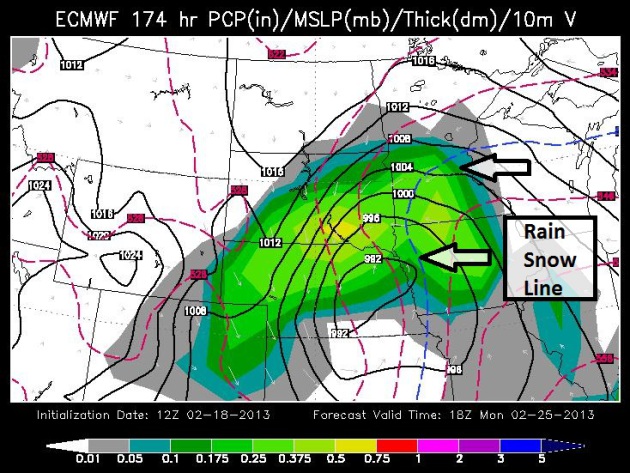
Monday Slop-Storm?
It's early - this thing is still 6 days away. But the ECMWF model shows
a storm near Omaha by midday Monday, with the rain-snow line pushing
across central Minnesota. I'm also concerned about the "dreaded dry
tongue", sometimes called the "dry slot", a surge of dry, desert air
pushing in from the south, which may cut off the heaviest precipitation
by Monday night. Again, the details on next week's storm are still
(very) sketchy.
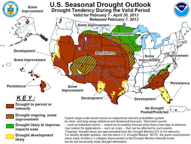
Forecasters Worry About Another Drought In 2013. I'm
a little more optimistic now, after watching the maps and trends
carefully (more southern moisture from the Gulf of Mexico is finally
reaching the Midwest after a long dry spell since last autumn). Here's a
snippet from a story at
indystar.com: "...
As
the spring planting season nears, forecasters have expressed concern
that much of the Midwest could remain starved for moisture, though
they caution it’s too early to safely predict the weather several
months out. The Midwest could see a late-summer increase in rainfall,
but the relief will be much too late to help farmers, according to one
prediction from a University of Missouri researcher.“The continuing
conditions really look like they’re setting up for a very similar level
of drought in the Midwest and West,” Roger Pulwarty, a director with
the National Oceanic and Atmospheric Administration who focuses on
drought, told lawmakers on the Senate Agriculture Committee last week..."
* the latest Drought Outlook from NOAA is
here.
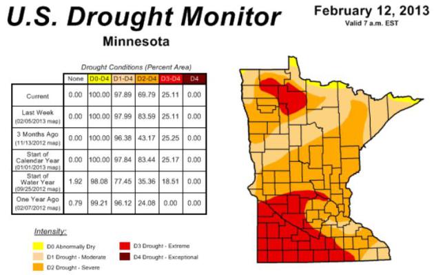
Encouraging Moisture Trends - Latest Drought Details. Here's an excerpt from the
Minnesota Climatology Working Group: "Thus far this winter, precipitation totals have been somewhat above historical averages
(maps below),
except in west central and north central Minnesota where winter
precipitation has been well above average. 2013 year-to-date
precipitation totals top historical averages by more than one inch
along a 75 mile-wide band centered along a transect from Wilkin County
to northwest St. Louis County.
Important points about winter precipitation and drought:
- Precipitation deficits (negative departures from normal) over
the past eight and one-half months are in excess of ten inches in some
southwest and south central Minnesota counties. Somewhat smaller, but
still significant, precipitation shortfalls were reported across
Minnesota over the past six months.
- As of late autumn, the soil moisture content in the plant rooting zone was near all-time low levels at many locations.
- The liquid content of our present snowpack
is unremarkable when compared with winters of the past. Snow water
equivalence estimates across Minnesota range from zero to three inches
in most places.
- The soil moisture situation will remain mostly unchanged until
spring because the deeply frozen soil (18-36 inches) assures that only a
fraction of the overwinter precipitation will make it into the
ground.
- When the soils thaw, and if the spring rains come, the dry plant
rooting zone will claim "first mortgage" on water infiltration. This
means that spring recharge of unconfined aquifers will be less than
typically expected. Water table well levels, and base flow to surface
water systems, will be slow to react.
- Without abundant spring rains, a number of critical drought
issues involving agriculture, forestry, horticulture, tourism, and
public water supply will begin to emerge.
* The latest U.S. Drought Monitor for Minnesota is
here.
Why We Love Beautiful Things. Here's a snippet of a fascinating article at
The New York Times that explains how our brains process (and appreciate) the world around us - what makes something beautiful vs. ugly? "...
Take color. Last year, German researchers found
that just glancing at shades of green can boost creativity and
motivation. It’s not hard to guess why: we associate verdant colors with
food-bearing vegetation — hues that promise nourishment. This could
partly explain why window views of landscapes, research shows, can
speed patient recovery in hospitals, aid learning in classrooms and
spur productivity in the workplace. In studies of call centers, for example, workers who could see the outdoors
completed tasks 6 to 7 percent more efficiently than those who
couldn’t, generating an annual savings of nearly $3,000 per employee..."
The Good 'Ol Days.
Temperatures peaked in the 30s yesterday, before a vigorous clipper
whipped up 20-40 mph winds, driving numbing air southward, whipping up
snow already on the ground - producing blizzard conditions over parts of
central and western Minnesota.
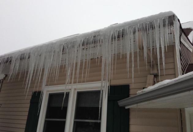
Ice Dam? Do you think I have to worry about ice dams?
Paul's Conservation Minnesota Outlook for the Twin Cities and all of Minnesota:
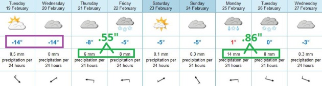
TODAY: Yukon breeze. Mix of clouds and sun. Feels like -15. Winds: NW 10-20. High: 5
TUESDAY NIGHT: Mostly clear, plenty cold. Low: -9
WEDNESDAY: Subzero start. More sun, less wind. High: 12
THURSDAY: Clouds increase. Snow at night. Wake-up: 5. High: near 20
FRIDAY: Snow tapers, few inches possible. Wake-up: 18. High: 26
SATURDAY: Mostly cloudy, better travel conditions. Wake-up: 17. High: 24
SUNDAY: Some sun, clouds increase PM. Wake-up: 14. High: 27
MONDAY: More snow, mixing with ice/rain? Wake-up: 19. High: 33
Climate Stories...
Experts: Global Warming Can Strangely Trigger Less Yearly Snowfall, But More Potent Blizzards.
It turns out the USA has experienced twice as many extreme winter
snowfalls in the last 50 years than the preceding 60, according to
NOAA's National Climatic Data Center. Here's the intro to a story at
The Star Tribune: "
With
scant snowfall and barren ski slopes in parts of the Midwest and
Northeast the past couple of years, some scientists have pointed to
global warming as the culprit. Then when a whopper of a blizzard smacked
the Northeast with more than 2 feet of snow in some places earlier
this month, some of the same people again blamed global warming. How
can that be? It's been a joke among skeptics, pointing to what seems to
be a brazen contradiction. But the answer lies in atmospheric physics. A
warmer atmosphere can hold, and dump, more moisture, snow experts
say. And two soon-to-be-published studies demonstrate how there can be
more giant blizzards yet less snow overall each year. Projections are
that that's likely to continue with man-made global warming..."
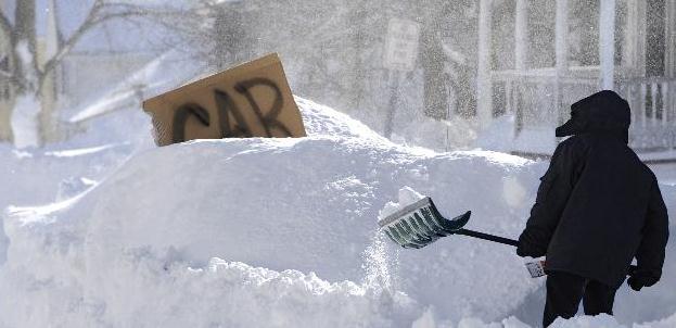
Photo credit above: "
A boy digs around a car marked with a
sign on a street in Windsor Locks, Conn., Saturday, Feb. 9, 2013. A
behemoth storm packing hurricane-force wind gusts and blizzard
conditions swept through the Northeast overnight." Photo: Jessica Hill, ASSOCIATED PRESS - AP
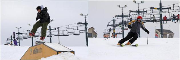
What I Love About Winter.
"It brings me roaring energy on my solar panels on a cool, very sunny, winter day."
- Mary Jo, Senior (trivia: solar panels are actually more efficient in the cold).
"Skating and being with my friends."
- Isla, Edina, age 8
"Being able to skate outside like I always dreamed of as a teenager in wet, soggy Scotland."
- Corral, Edina, age 46
"Minnesota winters (were) great...I could sled, snowboard, cross
country ski, ice skate, fish, build igloos, snow shoe, but in the last 3
years I have not been able to do this because the climate has warmed my
state."
- Christine, Brooklyn Park
"The sound of my blades scraping the ice as Lake Calhoun belches and
bubbles under my skates, and knowing that in 3 months I'll be paddling
in the same lake."
- Paul, Edina, age 64
Why see Bill McKibben at St. Thomas at 7pm on 2/20 and Macalester at noon on 2/21?
On Sunday 50,000 people came from all across the country to do more than say “NO” to burning and pipeing dirty Tar
Sands Oil. They came to say “YES” to being a part of the most important
social movement of our times. Creating the popular will that will lead
our elected officials to work together to solve the largest problem ever
to face humanity. As
Mindy Ahler, executive director of Minnesota Interfaith Power and Light,
a faith based organization to motivate congregations to take action on
climate change says:
“Bill is a visionary and leader who has put his heart and body into the global climate movement. It
is an honor and a privilege to have him spend this much time with us to
celebrate the season that defines living in Minnesota for me. He models the call to action which engages and inspires those around him to do the same.
"Now is the time for all good Minnesotans to come to the aide of the planet!” Mindy Ahler, Cool Planet Skier
Details and tickets at
Cool Planet.
Why Republicans Should Embrace The Reality Of Climate Change. I almost fell off my couch when I read this Op-Ed at
Forbes; here's an excerpt: "
We
have reached the point where every rational person who believes in
making decisions based on science and available data should, if not
fully believe that human beings are warming the planet by releasing
greenhouse gases, at least recognize that this is what the data seem to
suggest and that it is what the vast majority of scientists who study
weather believe is the case. Recognizing this does not force anyone to
oppose pipelines, support a carbon tax, or start composting and
wearing hemp shoes. It just opens us up to start aiming our fiery
furnace of a political system at actually solving our problems. Go
ahead, argue that the economic cost of anti-greenhouse measures
doesn’t justify the benefit, especially if the planet is getting too
hot..."
Call For Christie To Consider Climate Change In Shore Rebuilding. Here's a segment from a good story at
philly.com: "....
Christie
sees larger environmental factors as irrelevant. "Maybe in the
subsequent months and years, after I get done with rebuilding the state
and getting people back in their homes," he said, "I'll have the
opportunity to ponder the esoteric question of the causes of the storm."
While scientists acknowledge that evidence doesn't yet exist to say
climate change caused Sandy, they do know that sea levels are rising -
maybe an additional four feet in New Jersey by 2100, according to a
Rutgers University estimate. Research also shows that climate change may
be making storms more intense. That means that, if there's another
storm surge of the kind that swept houses off foundations during Sandy,
even more water may rush ashore. All of this must be evaluated before
the state rebuilds, scientists say..."
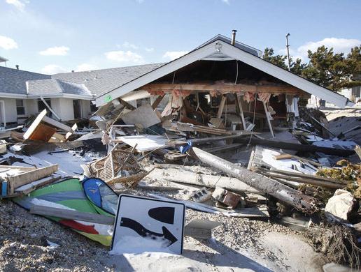
Photo credit above: "
Storm-destroyed house in Ortley
Beach. N.J.Gov. Christie, in efforts to rebuild at the Shore, sees
environmental factors as irrelevant." MICHAEL S. WIRTZ / Staff
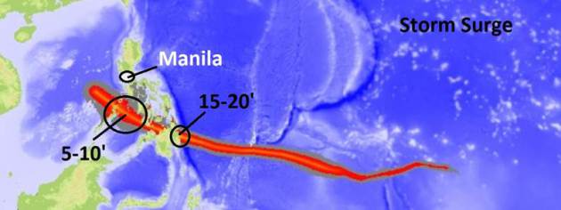
Filipino Super-Typhoon An Ominous Warning Of Climate Change Impact.
I tracked this typhoon for our corporate clients with offices in
Manila - I couldn't believe I was tracking a Category 5
hurricane/typhoon in early December, a symptom of unusually warm ocean
water in the western Pacific. Here's an excerpt from
The Guardian: "...
Lorenzo
Balbin, the mayor of New Bataan, said the fury of the storm was far
beyond the experience of anyone living in Mindanao. It would take 10
years to replace the coconut crop, he said. Some villages in Compostela
Valley may be too unsafe to live in. Bopha, known locally as Pablo,
broke records as well as hearts. At its height, it produced wind speeds
of 160mph, gusting to 195mph. It was the world's deadliest typhoon in
2012, killing 1,067 people, with 800 left missing. More than 6.2
million people were affected; the cost of the damage may top $1bn. As a
category 5 storm (the highest), Bopha was significantly more powerful than hurricane Katrina (category 3), which hit the US in 2005, and last year's heavily publicised hurricane Sandy (category 2)..."
Billionaire Has Unique Role In Official Washington: Climate Change Radical. Here's an excerpt of a story at
The Washington Post: "...
But Steyer is taking on a more prominent public role. On Sunday, he spoke to a crowd that organizers estimated at 35,000, gathered on the Mall to call for a stronger national climate policy.“I’m
not the first person you’d expect to be here today. I’m not a college
professor and I don’t run an environmental organization,” he said.
“For the last 30 years I’ve been a professional investor and I’ve been
looking at billion-dollar investments for decades and I’m here to
tell you one thing: The Keystone pipeline is not a good investment.”
The move stems from an uncomfortable conclusion Steyer has reached:
The incremental political victories he and others have been
celebrating fall well short of what’s needed to avert catastrophic global warming.
“If we can win every single battle and lose the war, then we’re doing
something wrong,” he said, moments after consuming two mochas on the
table before him..."


No comments:
Post a Comment