56 F. high in the Twin Cities Saturday. Warmest since November 22, 2012.
49 F. average high on March 30.
50 F. high on March 30, 2012.
Trace of snow left in the Twin Cities.
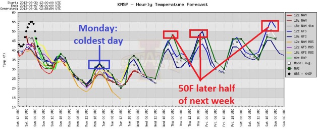
Freezing: predicted high on Monday. Wind chills dip into the teens.
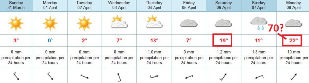
70F ? ECMWF model is hinting at 70 a week from tomorrow.
Happy Easter
Favorite oxymorons: jumbo shrimp, airline food
& global warming. 93 percent of warming is going into Earth's
oceans. La Nina and volcanoes can temporarily mask the warming.
And record Arctic ice melt last September may be
displacing numbing air that should be over the North Pole closer to our
zip codes this spring.
"Global weirding" might be a better descriptor:
more erratic weather; more extremes and Black Swan weather events that
leave us scratching our heads in wonder.
After morning showers and T-showers skies
cleared yesterday, bringing the first 50s since December 3. Vague hints
of what's to come. Today: nearly 20 degrees cooler; tomorrow may bring
back fond memories of late February - we'll be lucky to hit 32F.
Twins fans: pretend you're going to a December Gophers game at TCF Stadium.
It won't stay cold for long. 50F returns by the end of this week; the ECMWF hinting at 60s by Saturday. Be still my heart.
Call me a naive optimist, but this slow ramp
into spring bodes well for our drought. Showers & T-showers return
Saturday, and we morph into a much wetter pattern the second week of
April, with more moisture spurting out of the Gulf of Mexico.
A little good news?
Cold Twins Home Opener. We'll see who the TRUE Twins
Fans are on Monday - who turns out to brave wind chills in the teens. I
enjoyed this post in Mark Seeley's latest
WeatherTalk Newsletter: "
According
to historical analysis by Pete Boulay of the MN State Climatology
Office it appears that the Minnesota Twins may open the season Monday
(April 1st) with the coldest temperatures ever for this occasion, highs
forecasted to be in the low-30s F. The coldest home opener in
franchise history was on April 14, 1962 when the daytime high was 34
degrees F (Twins lost to the Angels 12-5 at the old Met). The Twins are
scheduled to open against the Detroit Tigers at 3:10 pm on Monday,
April 1st at Target Field with an expected temperature of 32 degrees F,
and windchill in the high teens F to low 20s F. Long underwear under
the uniform may be the common wardrobe that day. Incidentally the
warmest ever home opener? On April 22, 1980, again at the old Met
against the Angels the temperature was 90 degrees F (Twins won 8-1).
You can read more about the weather for Twin's Home Openers at..."
http://www.climate.umn.edu/doc/journal/Twins_home_opener_weather.htm
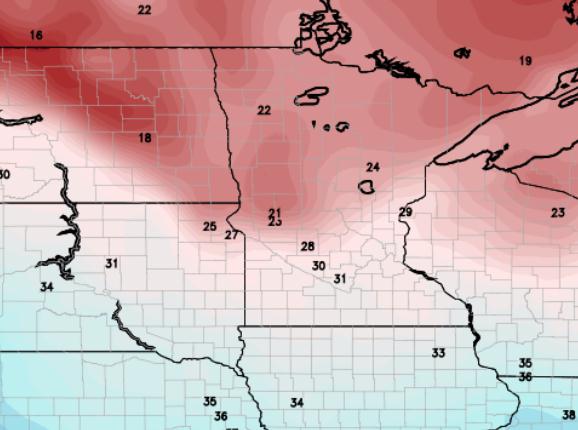
* Map above shows ECMWF predicted temperatures at 1 pm Monday.
 Winter Relapse
.
I won't go on record saying this will be the last cold front of the
winter season (I'm not that crazy), but this may be the last time
MSP has to struggle just to reach freezing (Monday). A high sun angle
results in a rapid rebound next week; highs near 50 from Wednesday into
Friday, maybe significantly warmer by next weekend. Graphic: Iowa State.
Temperature Double-Take.
Yes, the predicted highs above are in Celsius, courtesy of the
ECMWF (European) model. After peaking near 32F Monday temperatures
recover by the middle of next week. The "Euro" is hinting at 60s next
Saturday, even a shot at 70 by Monday of next week. By then there will
be precious little snow left around the Twin Cities metro.
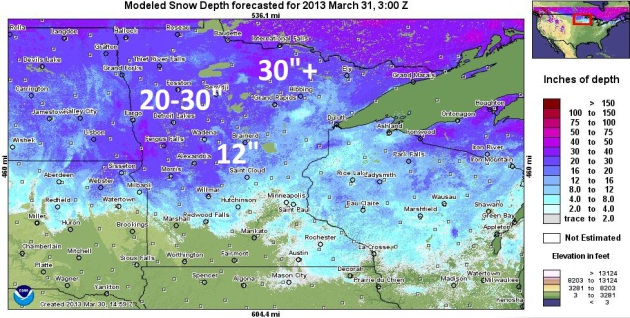
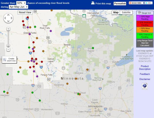
What Keeps River Forecasters Up At Night? Although
snow is going fast in and around the Twin Cities metro, there's still
closer to a foot on the ground just north/west of St. Cloud, closer to
20-30" snow from Morris and Alexandria to Detroit Lakes, Bemidji and
much of the northwestern third of Minnesota, according to NOAA
calculations.
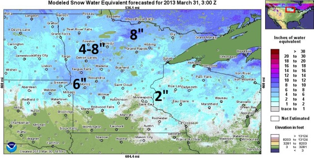
Snow Water Equivalent. What's important isn't how
many inches of snow is left up north, but the SWE, or snow water
equivalent - how much water is locked up in that snowpack. As much as
4-8" of water is in the snow west of Brainerd and Wadena. A worst case
scenario for river flooding would be a temperatures spike into the 50s
and 60s, coupled with significant rain. That scenario may be shaping up
in 6-10 days - something we'll need to keep a very close eye on.
Flood Potential Grows. As much as 5-8" water in the
snowpack over much of the Red River Valley, coupled with lingering chill
(and little melting in recent weeks) has increased the potential for
major flooding, especially on the Red River from Montevideo to Fargo and
Crookston.
Details from NOAA: "
Areas of concern that have an increased risk over the historical flood history include:
· Minnesota River at Montevideo (Much above normal – now an 86% chance to see minor flood stage of 14 ft.)
· Long Prairie River at Long Prairie (Above normal now has a >95% chance to see minor flood stage of 6.0 ft.)
· Mississippi River at Aitken (above normal ~ 85% chance to see minor flood stage of 12ft)
· Mississippi River at St Cloud (above normal now has a 52% chance to see minor flood stage of 9.0 ft.)
"
The threat for ice jams is increasing. This is especially of
concern for the upper Mississippi River (Anoka and upstream) and on the
Minnesota River. Information that would be very helpful to know include
location of the jam (more prone locations include river bends and
bridges), tupe of ice (solid sheets or "chunks"), length of the jam and
is water rapdily rising behind the jam."
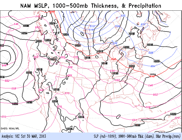
Too Early To Retire The Parka. You'll need a heavy
jacket or coat Monday, probably Tuesday, as one more shot of numbing air
surges south of the border. Winds ease up Tuesday as high pressure
slides overhead; moderating temperatures by Wednesday. Yes, this too
shall pass. 84-hour NAM animation courtesy of NOAA.
Coldest March For The UK Since 1962. The
UK Met Office
has the details: "This March is set to be the coldest since 1962 in the
UK in the national record dating back to 1910, according to
provisional Met Office statistic. From 1 to 26 March the UK mean
temperature was 2.5 °C, which is three degrees below the long term
average. This also makes it joint 4th coldest on record in the UK.
Looking at individual countries, March 2013 is likely to be the 4th
coldest on record for England, joint third coldest for Wales, joint 8th
coldest for Scotland and 6th coldest for Northern Ireland.
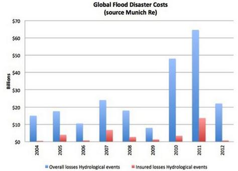
Why You Are Paying For Everyone's Flood Insurance.
Yahoo News has the story; here's an excerpt: "
There are many, many compelling and urgent reasons to take decisive action to combat climate change.
Here's one that's measurable by dollars added to our budget deficit.
Actually by tens of billions of dollars. The soaring cost of private flood insurance
is pricing so many coastal homeowners out of the market that the rest
of the American taxpayers are having to bail them out – to the tune of
$30 billion under the National Flood Insurance Program (NFIP). With over $139 billion in storm, wildfire, drought, tornado and flood damages taking nearly 1 percent of U.S. gross domestic product (GDP) in 2012, the insurance industry
is referring to last year as the second costliest year on record for
U.S. climate-related disasters. And while insurers do include $12
billion worth of flood-related damages in their estimates, they aren't
the ones getting stuck with most of the bill. It's us, the taxpayer..."
Hurricane Center Again Breaks Accuracy Records. NHC did a good job last year, overall. Heres' a good recap from
SunSentinel: "
Once
again, the National Hurricane Center again broke forecast track
accuracy records during the tumultuous 2012 storm season. While issuing
444 advisories for the likes of Hurricanes Isaac and Sandy, the center
set track prediction records for every forecast period except for the
longest one, which predicts what a storm will do over the next five
days. Here are the average errors:
For the 12-hour period: 28 miles, down from 32 miles last year.
For the 24-hour period: 45 miles, down from 50 miles..."
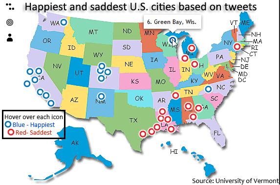
15 Happiest And Saddest U.S. Cities Based On Tweets.
Not sure if it's scientifically possible to deduce who is happy vs. sad
from tweets, but I found it vaguely interesting that the happiest
people tend to live in the western half of the USA (with the exception
of Green Bay).
ThingLink has the infographic.
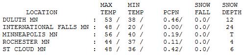
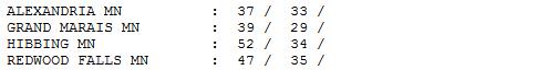
Instant Spring. Yes, the weather turned out nicer
(and milder) than predicted yesterday. We did see showers and even a few
T-showers early in the morning, but skies quickly cleared, allowing the
mercury to push into the 50s. Highs ranged from 37 at Alexandria to 48
St. Cloud to 56 in the Twin Cities.
EASTER SUNDAY: Mostly cloudy, colder wind. Winds: NW 15-25. High: 39 (falling)
SUNDAY NIGHT: Lingering clouds, a few flurries. Low: 21
MONDAY: Partly sunny. Mostly cold. Windchill: 15-20. High: 32
TUESDAY: Bright sun with less wind. Wake-up: 19. High: 35
WEDNESDAY: Fading sun, not as chilly. Wake-up: 25. High: 47
THURSDAY: More clouds, stray shower. Wake-up: 31. High: 51
FRIDAY: Partly sunny, probably dry. Wake-up: 33. High: 48
SATURDAY: Warmer, passing T-shower? Wake-up: 38. High: 63
Climate Stories...
James Inhofe "Proud" To Be A Target In Climate Change Documentary.
Huffington Post has the story; here's an excerpt: "
Sen.
James Inhofe is taking criticism of his climate change denial as a
compliment. The Oklahoma Republican is one of the central targets in the
newly released climate change documentary "Greedy Lying Bastards,"
which examines attempts by the fossil fuel industry to thwart emissions
standards and mispresent the facts in the face of changing global
climate conditions. The film airs Friday at a special screening in
Tulsa, Okla. "I was not surprised to see myself front and center on the
promotional material for this climate change movie," he told the Tulsa World, "and quite frankly, I'm proud of it." Inhofe has long called climate change a "hoax," insisting "we're in a cold spell" when it snows, despite the body of scientific evidence showing that humans contribute to global warming..." (Photo: AP).
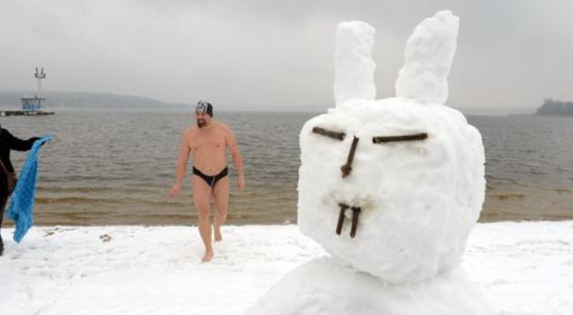
Q&A: Europe's Freezing Easter, Global Warming And Melting Arctic Ice.
The Washington Post
does a good job explaining how record melting of Arctic ice last year
may be displacing unusually cold air south, creating colder than average
conditions across much of North America, Europe and Asia. Here's an
excerpt: "...
Global warming is melting the ice cap over the Arctic
Ocean. Last September, it reached its lowest extent on record. Climate
models show that the loss of sea ice — which acts as a lid on the
ocean, preventing it from giving off heat — triggers feedback
mechanisms that shake up the climate system further. A series of
studies in recent years have shown that one such effect could be
changes in atmospheric circulation, resulting in more frequent cold
snaps in Europe.
Q: How would melting Arctic ice lead to cold snaps?
A: The theory is the loss of sea ice means more heat is released
from the open ocean, warming the layer of polar air over the water.
That reduces the temperature and air pressure differentials with more
southern latitudes, increasing the likelihood of a negative state in
the atmospheric circulation..."
Worst Allergy Season Ever? Fantastic. Something to look forward to.
Live Science has the story; here's an excerpt: "
This
spring could be the most miserable one ever for those of us with
allergies, and we can blame it on climate change. People in the
Northeast, in particular, will be among the hardest hit in the
aftermath of Hurricane Sandy and this winter's record-setting blizzard,
both of which dumped massive amounts of precipitation over the
region. "[This] promises a robust allergy season,'' said Leonard
Bielory, an allergy and immunology specialist with the Rutgers Center for Environmental Prediction
in New Jersey, a state which suffered widespread destruction from
Sandy. "The first airborne tree pollen has been measured in recent
days, and while the count is still low, some allergy sufferers are
showing comparatively severe symptoms,'' he added. "I expect more tree
pollen than ever to be released this spring, and the reaction to the
early pollen to be unusually strong...''
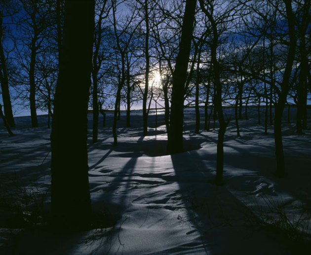
Photo credit above: dreamstime.com.


No comments:
Post a Comment