Confused Clipper
By Todd Nelson
"Misery
loves company" -- "When it rains, it pours" -- how about the second
half of our winter season? Since February 1st, the Twin Cities has seen
24.4" of snow. That's an average of about 0.60" of snow per day during
that 39 day period. November thru January only saw 20.4" of snow, which
equates to an average of nearly 0.20" per day over that 92 day period.
With that said, if you feel like we've had more snow lately, you're
right!
A confused clipper will roll thru today with light snow potential today. We're still muddling through March... -Todd Nelson
________________________________________________________
Todd's Conservation MN Outlook for the Twin Cities and all of Minnesota:
TUESDAY NIGHT: Light snow tapers early. Low: 15
WEDNESDAY: Feeling cooler. Sunnier day of the week. High: 31
THURSDAY: Clouds thicken. A few flakes or sprinkles? Wake-up: 19. High: near 37.
FRIDAY: Mostly cloudy. Light rain/snow mix possible, mainly north. Wake-up: 26. High: 38.
SATURDAY: Mostly cloudy, passing flake. Low: 26. High: 38
SUNDAY: Developing storm? Warm enough for rain? Low: 26. High : 39
MONDAY: Rain/snow mix possible. Low: 28. High: 40
_________________________________________________________
Tuesday's Clipper
A fairly week clipper storm will slide
through the Upper Missississpi Valley on Tuesday with some light snow.
Other than a light coating, It doesn't appear to be much across the Twin
Cities region. The best chance for some light shoveling would be across
the Red River Valley.

Mother Nature seems to be a little confused right now... We're getting reports of flowers/plants growing/budding across the far north where it is still snowing! Thanks to Tom Purdy for the picture below out of Janesville, WI... Note the daffodil chutes with big snow piles in the background.

Thanks
to my good friend Jon Ellis for this picture out of Superior, WI where
little plant chutes are trying to poke out of the ground as well!

The Snow Threat Finally Settles
After
several days of snow across the central part of the country, our snow
threat is beginning to settle a bit today. This storm was responsible
for several inches of snow from the Southwest to the Great Lakes over
the past several days.

Here are some of the highest snowfall tallies that I could find (reported earlier today)

Snowy Scene in Iowa
Thanks
to @tiara21nicole for the picture below out of Eagle Grove, IA... The
moisture-laden nature to the snow helped with the stickiness of the
snow, so most things were coated with white earlier Monday!

Much Needed Moisture...
We've
been making up for lost time this February and March. Places that had a
lackluster first half of the winter season have been seeing decent
uptick in the wintry weather in February and March.

Seasonal Snowfall Surpluses?
Thanks
to some heavy February and March snowfalls, several locations are now
reporting snowfall surpluses! Something that was uncommon prior to just
a few weeks ago.


Near Normal Snowfall in Chicago
February
and March have been quite snowy for folks in Chicago. So far this
month, we've seen nearly 10" for a grand total of nearly 30" for the
season!

Near Normal Snowfall in Milwaukee
February
and March have also been quite snowy for folks in Milwaukee, WI. So
far this month we've seen nearly 4" for a grand total of nearly 42" for
the season!

Snow Water Equivalent
Nearly
35% of the country has snow cover on this March 11th and there is
quite a bit of water locked up in that snow across the far north. This
is always a concern as we get closer and closer to flood season. The
threat for a rapid snow melt and heavy rain could bring flooding
concerns to a premium.

7 Day Precipitation
The
weekend storm system not only brought heavy snow to parts of the
central part of the country, but it also brought heavy rainfall. Some
spots across southeast Iowa picked up over 3" of liquid, that plus
melting snow had caused some flooding concerns.

Flooding Concerns
The latest river gauge info from NOAA suggests that there are several river gauges that are seeing some flooding.

Flood Outlook
The NWS Significant Flood Outlook suggests that flooding is likely March 10th-15th in the areas shaded in orange below.

Storm Next Week?
The ECMWF (European model) suggests that next week could be a little more interesting. It's a ways out, but something to watch!

_____________________________________________________________
Ask Paul/Todd:
Steve Carlsen writes:
"I’ve
having a discussion with a friend of mine about how much snow we’ve had
vs. last year. (2012/2013 vs. 2011/2012). He says we’ve had LESS, I say
we’ve had more. For the Minneapolis/St.Paul metro area, who is right?"
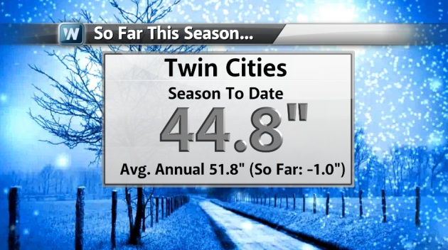
Thanks
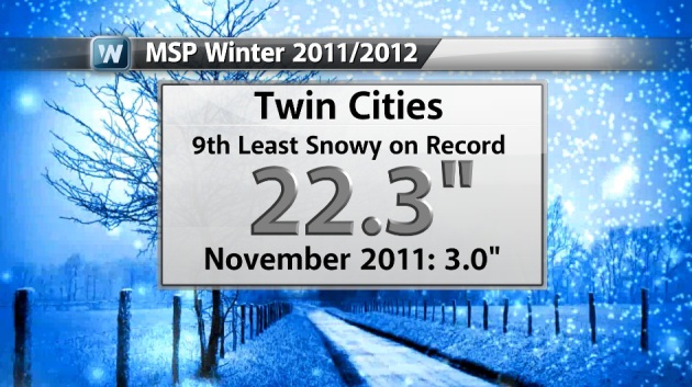
for the question Steve. Yes, you are right. Last winter, the entire
winter only saw 22.3" of snow, so far this winter, we've seen 44.8" of
snow 'officially' at the Minneapolis/St. Paul International Airport. We
are currently sitting around 1" behind normal snow through mid march and
typically see nearly 52" per winter.
Not only was the 22.3" well below the average annual of 51.8", but it was also the 9th least snow winter on record!
__________________________________________________________________
John Mather Writes:
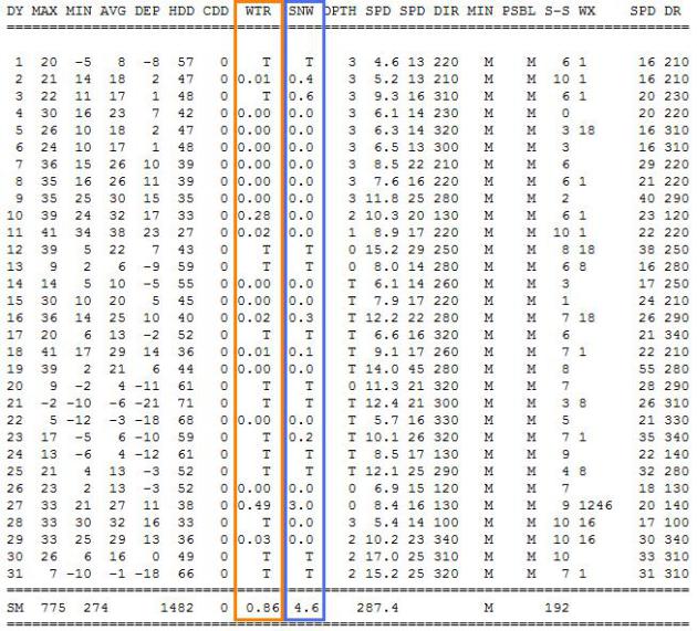
"I am looking at the precipitation accumulation for Jan 2013 on the Weather Network site. What does this number mean? Is the amount shown represent snow lying on the ground or is it the equivalent amount if rain had fallen?"
Thanks for your question John. Precipitation accumulation means the total accumulation of any rain/sleet/snow melted down into the liquid fasion, so yes, it means the precipitation equivalent if rain had fallen. The 'official' reading at the Minneapolis/St. Paul International Airport for January 2013 was 0.86" of total liquid precipitation. Some of that precipitation fell in the form of snow, which accumulated to 4.6".
Thanks for checking in, have a great rest of your week!
Don't forget to follow me on Twitter @TNelsonWNTV

No comments:
Post a Comment