By Todd Nelson
A certain groundhog named Phil is WANTED for fraud! I seem to remember a large rodent making bold predictions about an early start to the warm season. Not only was he wrong, but we seemingly found a way to slip back into Winter's arms... UGH! In fact, we've seen more snow since the start of February (nearly 30"), than we did through the 92 day period of November, December and January (around 20").
At 6:02am Wednesday, the sun's most direct rays will cross the Equator, marking the start of Spring for us in the northern hemisphere. Average high temperatures for us are in the low to mid 40s right now, we'll struggle to top out at 20° on Wednesday! Last year on March 19th, the mercury topped out at an early summer-like 65°.
Marchuary continues through much of the week as we stumble back close to the freezing mark by Friday. The average temperature for March is running nearly 4.5° below avearge, which is on the other side of the scale than March 2012, when the average temp was 15.5° above avg.; the warmest on record.
Some models suggest another shot of snow this weekend, adding to our 49.3" of snow so far this season; 52.8" is the winter average.
_____________________________________________________________________
Todd's CONSERVATION MN Outlook for the Twin Cities and all of Minnesota:
TUESDAY NIGHT: Breezy and colder than average. Low: 4. Winds: NW 15mph Wind: Chill: -5° to -15°
WEDNESDAY : Spring arrives! Winter lingerings with a few flurries High: 19. Winds: NW 15mph
WEDNESDAY NIGHT: Cold. Low: 4.
THURSDAY: Marchuary continues. High: 24.
FRIDAY: Jacket worthy, clouds thicken late. Low: 8. High: 31.
SATURDAY: More clouds, some light snow? Low: 18. High: 34.
SUNDAY: Increasing snow potential. Low: 24. High: 36.
MONDAY: Lingering light snow possible. Low: 23. High: 34.
TUESDAY: Another cool day. Flurries? Low: 20. High: 34.
_________________________________________________________________________________

Spring Begins at 6:02am Wednesday... Or Does It?
Even though Spring arrives on Wednesday, temperatures will feel quite a bit more like Winter in the eastern half of the country.

Highs From Normal on Wednesday
Blue is not necessarily the color we want to see here. We can handle
a little cold, but temperatures on Wednesday will be running nearly
10° to 20° degrees below normal for a good chunk of the eastern part of
the country.

The 6 to 10 day temperature outlook continues to look cold in the eastern part of the country. This will take us to the end of the month. I don't see Spring on weather maps either.

Cold and Snowy...
The landscape looks very wintry in the Twin Cities area doesn't it?
The image below was out of St. Paul, MN from Tuesday afternoon. The
Twin Cities has seen nearly 14" of snow so far this month and nearly
50" this season!

2012 vs. 2013
The Twin Cities is dealing with some much different weather this
year vs. last. Thanks to KARE 11 photojournalist Deb Lyngdal for the
picture below. Keep in mind that on March 18th, 2012 - the Twin Cities
warmed to 79° and is the current record high for that date... If you
look closely at the picture below, I'm wondering if that red car has
moved since last year??

Twin Cities March So Far...
March 2012 was the warmest March on record. Average temperatures
were running 15.5° above average. This year (thru the 18th)
temperatures were running nearly 4° below average.

Nearing Avg. Seasonal Snowfall
So far thru March 18th, the Twin Cities had 49.3" of snow, which is
nearing the average annual snowfall of 51.8". Interestingly, 28.9" of
that has fallen since February 1st!

Snowy February and March...
Thanks to a snowy February and March, we've made up for lost time in
many locations. Look at the departure from normal snowfall across the
region. Many locations have either dramatically cut their deficits down
or are now at a surplus!


Snow Depth
As of Tuesday, there were locations across the far north that had nearly 2ft. to 3ft. of snow still on the ground!

SWE? Snow Water Equivalent
The SWE or snow to water equivalent is still quite impressive across
the far north where deep snowpack exists. There are still a few spots
that have nearly 5" of water locked in the snow!

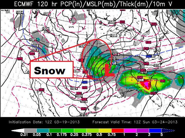
Snow Potential
Extended models are suggesting a storm by the late week/weekend that
could produce heavy snow across the Plains and central part of the
country. The ECMWF (European model) keep the heaviest along the Front
Range of the Rockies to the Ohio Valley.
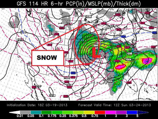
GFS Farther North
The GFS (American model) suggests that the precipitation will drift a
little farther north. I'd like to see a few more model runs before
putting all my chips in. Stay tuned for more!
Monday's Severe Weather
Take a look at the incredible image below. That's a semi truck that
was nearly blown off of an overpass from thunderstorm winds. The man in
the picture is the driver of that rig! Wonderful to see that he is
unharmed!

Active March 17th
Two tornadoes were confirmed in Tennessee as well. Here's a picture
from the National Weather Service out of Nashville, TN where an EF1 was
confirmed.

Massive Hail
Monday's thunderstorm activity also spawned massive hail across the Southeast. Yea, that's a softball!

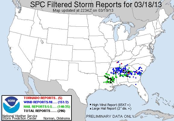
Monday's Storm Reports
Here are the 'filtered' storm reports from Monday, which tries to
eliminate multiple reports from the original storm reports. This is
done to get a more accurate count on total storm reports. It appears
that Monday was the most active severe weather day we've seen since
late January 2012.
2013 Tornado Count
Interestingly, we've see more tornadoes in January (87) and February
(46) than what we've had in March (5). This is also below the average
number of tornado reports by this time of the year.

National Tornado Average By Month
According to NOAA's SPC, this is what the national tornado average
is by month. Note how the average spikes in May at 276. We typically
see 80 tornadoes in March... Our low count can be attributed to the
colder than average readings so far this month.

NEW Summer Slot Limit on Declining Lake Mille Lacs Walleye Population
"Mille Lacs walleye anglers will be limited to two fish beginning May 11, the Minnesota Department of Natural Resources said Tuesday morning.
The harvest slot wil be 18 to 20 inches. One walleye in the two-fish limit can be larger than 28 inches.
Last year the limit was four walleyes, with only walleyes under 17 inches allowed to be kept, except that one could be longer 28 inches. Fish the smaller size were difficult to find."
Read more from Startribune.com HERE:

Thanks for checking in, have a great rest of your week!
"Mille Lacs walleye anglers will be limited to two fish beginning May 11, the Minnesota Department of Natural Resources said Tuesday morning.
The harvest slot wil be 18 to 20 inches. One walleye in the two-fish limit can be larger than 28 inches.
Last year the limit was four walleyes, with only walleyes under 17 inches allowed to be kept, except that one could be longer 28 inches. Fish the smaller size were difficult to find."
Read more from Startribune.com HERE:
Thanks for checking in, have a great rest of your week!
Don't forget to follow me on Twitter @TNelsonWNTV

No comments:
Post a Comment