Spring Ahead
By Todd Nelson
By Todd Nelson
The weather seems to be about as
groggy as I feel today with that dreaded time change... Ugh! It always
seems harder to 'spring' ahead than it does to 'fall' back, doesn't it?
Not sure I'm a big fan of losing an hour, especially when it seems like
there isn't enough time to get everything done as it is. The only nice
thing about the change is that our sunsets will be one hour later now!
March is a big transition month for
us. Not only do we see a significant increase in the amount of sunlight
we get per day, but the strength of the sun increases dramatically too.
This improvement helps to promote warming, which helps to eat away at
our snowpack. Since 2003, the average date when the snow depth reached
zero officially at the MSP Airport in spring was March 31st. Earliest
was last year on March 7th and the latest was in 2008 on April 27.
Sunday's rain put a big dent in our
current snow pack, which topped out at 13" officially last Wednesday. I
wouldn't doubt it if by the end of the week we start seeing a few more
brown spots on area lawns as snow continues to melt.
In the meantime, we'll have to keep puddle jumping, hope your feet stay dry! -Todd Nelson
_______________________________________________________________________
Todd's Conservation MN Outlook for the Twin Cities and all of Minnesota:
SUNDAY: Waking up to a little slush? Sidewalks could be a little icy too. Windy, cooler. Few flurries. High: 30 Winds: North 10-20
SUNDAY NIGHT: A few lingering light snow showers possible, mainly south and east. Low: 19
MONDAY: Partly sunny and brisk. Wake-up: High: 31
TUESDAY: Mostly cloudy, a cool wind with a flake or two possible. Wake-up: 19. High: 31
WEDNESDAY: Clipper, light mix? Wake-up: 18. High: 32
THURSDAY: AM shower, turning milder. Wake-up: 20. High: near 36
FRIDAY: Mix of clouds and sun. Wake-up: 24. High: 37.
SATURDAY: Partly sunny with a few sprinkles north? Low: 28. High: 39
_______________________________________________________________________
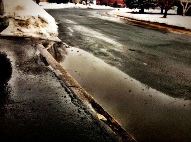
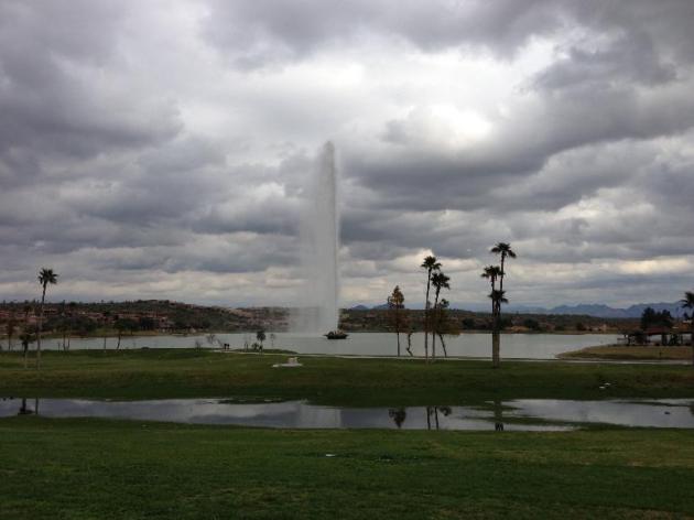
A Bit Puddly
Thanks to my sister Michelle Musil for the
picture below who noted a large puddle on Saturday afternoon. Thanks to
an early March 'tournament' snowstorm and some recent mild
weather/rain... puddles are showing up in neighborhoods near you! The
Minneapolis/St. Paul International Airport had a maximum snow depth on
March 6th of 13" -- Midday Friday, that snow depth had dropped to 11" --
thanks to 0.40" of rain Friday night/AM Saturday, it had dropped to 8"
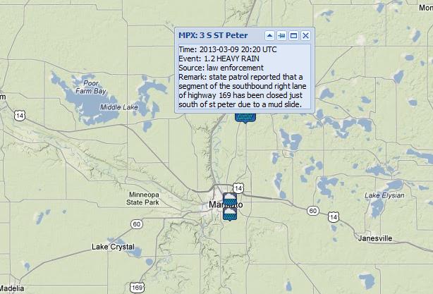
Flood Reports
With the recent heavy rains and rapid snow
melt, there were a number of standing water reports. A few more
'substantial' reports came in from the St. Peter/Mankato area. Portions
of hwy 169 near St. Peter were closed due to a mud slide.
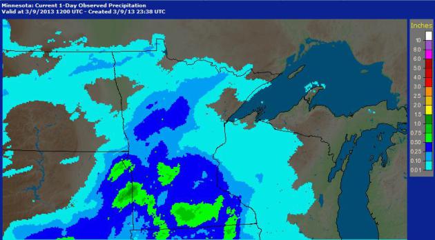
Precipitation Today
Sunday's precipiation across
southern Minnesota was on the order of 0.50" to 0.75" of an inch and was
substantial enough to cause some minor flooding across the region.
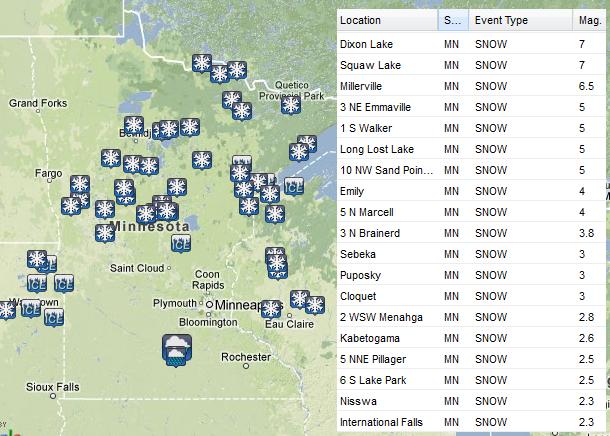
Snowfall Reports
Unfortunately, this storm wasn't
as cut and dry as the system earlier this week. There was a wintry mix
across parts of the region including some freezing rain. There were also
some shovelable snowfall reports that came in across western and
northern Minnesota. The heaviest snow 7" in northcentral part of the
state.
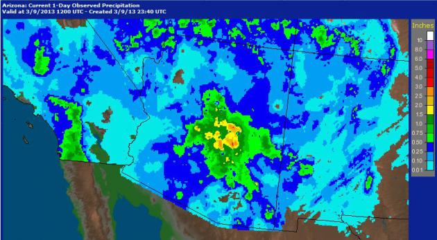
Speaking of Rain...
How about that rain in Phoenix
on Friday? 0.84" on Friday in Phoenix becomes a new record for the day.
There were some spots that picked up over 1"
More Snow on the Way
The same storm that brought
heavy rain to parts of the Southwest/Midwest and heavy snow to parts of
the Front Range of the Rockies will also bring heavy snow to parts of
Wisconsin Sunday-Monday
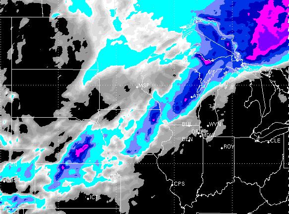
U.S. Snowfall Next 3 Days
Here's a look at the U.S. Snowfall over the next 3 days.
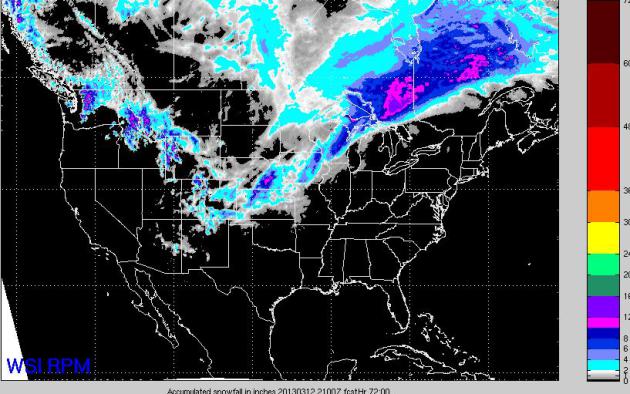
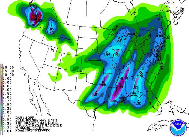
3 Day Precipitation
NOAA's HPC 3 day precipitation
forecast suggest several rounds of heavier rainfall along the Gulf Coast
States as the storm system chugs east. A few vigorous thunderstorm may
be possible Sunday, but it won't be widespread severe.
Thanks for checking in, have a great rest of your weekend!
Don't forget to follow me on Twitter @TNelsonWNTV

No comments:
Post a Comment