1.3" total precipitation forecast for the Twin Cities by midday Friday (00z NAM model).
Sleet/Rain/Snow mix changes to mostly snow this afternoon, peaking tonight before tapering Friday morning.
3-6" amounts possible tonight and early tomorrow.
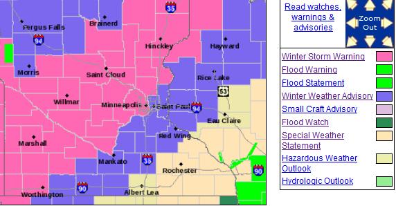
Winter Storm Warning in effect, including the Twin Cities.
42 F. high Wednesday in the Twin Cities.
59 F. average high for April 17.
58 F. high on April 17, 2012.
.04" rain fell yesterday as of 7 pm.
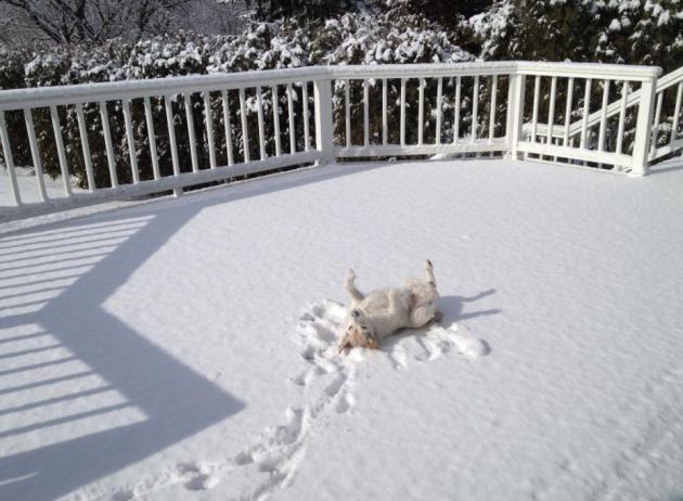
Winter's Last Gasp?
"You're in the dog house, Paul" a friend told me
yesterday. No, I'm several levels below the dog house. "Forget the
robins - I just saw the first real sign of spring, street sweepers!" he
gushed.
Uh oh. More shoveling before we get to street sweeping.
The rumors are true: heavy, slushy snow is
shaping up from later today into Friday morning. I'm thinking 3-5
inches; maybe 5-8" northern and western suburbs. Please avoid the
northern & western suburbs. A band of 6-10" may fall from St. Cloud
to Duluth.
Storm warnings are posted; a sloppy mix changing to mostly snow; heaviest tonight.
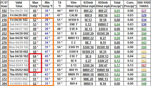
Before you let out a primal scream: long range
guidance shows 50F by the end of next week. 60s and even a few 70s may
be roughly 2 weeks away. Not a moment too soon. Maybe this is the Old
Man Winter's last sucker punch.
The sun is as high in the sky as it was in late
August. At some point (soon) we HAVE to warm up. The sun peeks out
Saturday; temperatures aloft warm enough for rain Sunday.
It could be worse: Pete Boulay at the Climate
Office says the latest 3" snow in the metro was May 20, 1892. Yep, that
was a tough year to be a weather guy, even worse than 2013: "The Year
Spring Forgot".
Winter Storm Warning. A warning means a significant
storm is imminent - on the way. Here's the latest from the Twin Cities
National Weather Service:
A WINTER STORM WARNING REMAINS IN EFFECT FROM 7 AM THURSDAY TO
10 AM CDT FRIDAY.

A WINTER STORM WARNING HAS BEEN ISSUED FROM 7 AM THURSDAY TO
10 AM FRIDAY.

* TIMING: LIGHT SNOW WILL DEVELOP EAST TO NEAR A LINE FROM REDWOOD
  FALLS...BUFFALO AND MORA OVERNIGHT...WITH A MIXTURE OF
  RAIN...SLEET AND SNOW TO THE EAST. PRECIPITATION WILL BECOME
  ALL SNOW THURSDAY MORNING...WITH PERIODS OF HEAVY SNOW THURSDAY
  AFTERNOON INTO THURSDAY NIGHT.

* SNOW ACCUMULATION: 6 TO 8 INCHES.

* OTHER IMPACTS: STRONG NORTH WINDS ARE EXPECTED THURSDAY
  AFTERNOON AND THURSDAY NIGHT...GUSTING AT TIMES TO 35 MPH.
  THIS WILL LEAD TO SOME BLOWING SNOW IN OPEN AREAS BY THURSDAY
  NIGHT.

PRECAUTIONARY/PREPAREDNESS ACTIONS...

A WINTER STORM WARNING FOR HEAVY SNOW MEANS SEVERE WINTER WEATHER
CONDITIONS ARE EXPECTED OR OCCURRING.  SIGNIFICANT AMOUNTS OF
SNOW ARE FORECAST THAT WILL MAKE TRAVEL DANGEROUS. ONLY TRAVEL IN
AN EMERGENCY. IF YOU MUST TRAVEL...KEEP AN EXTRA FLASHLIGHT...
FOOD...AND WATER IN YOUR VEHICLE IN CASE OF AN EMERGENCY.
Snow-Weary. For the record: I'm just as sick and
tired of showing this graphic as you must be by now. Models seem to be
converging on 3-6" amounts, with more possible northern and western
suburbs. Plowable tonight and early Friday. With any luck that's the
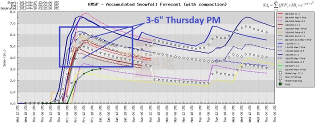
last time I have to say "plowable" for 7 months.
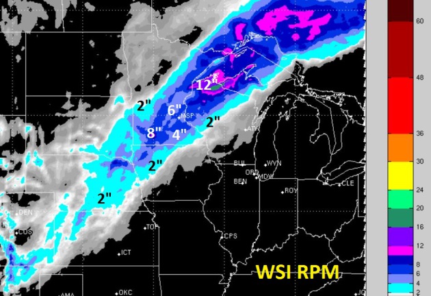
How Much? Here's the 00z WSI 12 km. RPM model,
hinting at some 3-6" amounts across the Twin Cities metro, closer to
10-12" for Duluth. That's quite enough, thank you. Worst case: 5-8" far
northern and western suburbs by Friday morning.
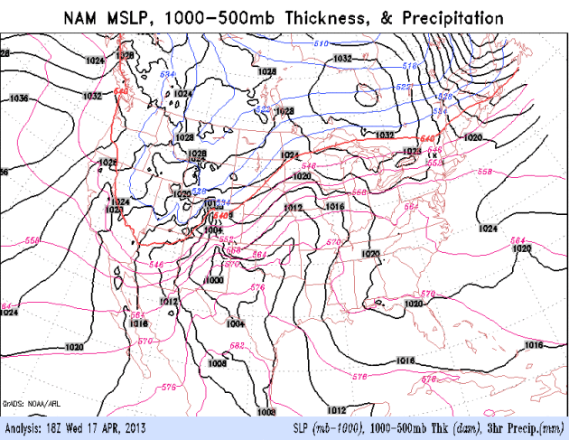
Another March-Like Storm. These full-latitude storms
move slowly, tapping copious moisture from the Gulf of Mexico. The
greater the temperature contrast from north to south, the greater the
potential for powerful jet stream winds to spin up a major storm (and a
significant tornado threat in the warm sector). NAM model: NOAA.
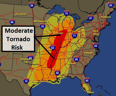
Significant Tornado Outbreak? There should be
sufficient low-level moisture, instability (CAPE) and wind shear for
potentially large, violent, long-track tornadoes later today. SPC has
elevated the risk to moderate from Chicago and South Bend to St. Louis
and Memphis. It looks like a busy, and potentially violent afternoon and
evening over the Mississippi River Valley. Map: SPC and Ham Weather.
Hints Of Spring (In One Week). While you muddle thru
sleet and snow today, rest assured that better days are ahead. Yes,
today I feel the need to put on my therapist hat and reassure you that
50s should return by the end of next week, based on ECMWF model data.
Extended Outlook. I will not jump out my second
floor office window today, after checking out the latest GFS model,
which continues to bring 50s into town late next week, with a few 60s
the following week, at the very end of April and early May.
Minnesota Tornado Drill Later Today. In spite of the
snowy mix, the test of the sirens will go on today, and I suspect the
timing is good, because I'm anticipating a severe May, statewide, as
warm, moisture-laden air finally surges north (in a very unstable,
sheared environment - ripe for supercells). We'll see, but I suspect
local TV meteorologists will be very busy in May and June. Here's more
information on today's drill from Todd Krause at the local Twin Cities
NWS:
Minnesota Schedule for Thursday, April 18, 2013:
1:00 p.m. Test watch. Offices will issue this via
Special Weather Statement. SPC is not issuing a test watch due to the
severe threat tomorrow.
1:45 p.m. Test Tornado Warning (TOR) issued by all six
weather offices that serve Minnesota. Weather Radios will activate with
the real TOR code.
2:00 p.m. Test Severe Weather Statement (SVS) issued
by all six weather offices to announce the end of the test warning. No
alarm on weather radio.
6:55 pm. Test Tornado warning (TOR) issued by all six
weather offices that serve Minnesota. Weather Radios will activate with
the real TOR code.
7:10 pm. Test Severe Weather Statement (SVS) issued by
all six weather offices to announce the end of the test warning. No
alarm on weather radio.
* Due to a risk of severe storms over Wisconsin later today the drill has been delayed until Friday. Details:
Wisconsin Schedule for Friday, April 19, 2013:
1:00 p.m. Test watch. The test "Watch County
Notification" (WCN) with the list of counties will be issued by all five
weather offices that serve Wisconsin. SPC will also issue a test WOU.
Weather Radios will activate with the real TOA code.
1:45 p.m. Test Tornado Warning (TOR) issued by all
weather offices that serve Wisconsin. Weather Radios will activate with
the real TOR code.
2:00 p.m. Test Severe Weather Statement (SVS) issued to announce the end of the test warning. No alarm on weather radio.
High-Tech Clear Channel Billboards Will Deliver Tornado Warnings.
Here's a press release from Dan Luna, Meteorologist In Charge of the
Twin Cities National Weather Service, that caught my eye yesterday:
"
Today I had the pleasure of
participating in a press release with Hennepin and Ramsey County EM's,
Hennepin County Board Chair, MN State Highway patrol, and the President
of Clear Channel Outdoor Communications. "Tornado warnings on
ClearChannel Signs Debut During Severe Weather Awareness Week"
The EMs in Ramsey and
Hennepin Counties partnered with Clear Channel to display our tornado
warnings on electronic billboards, assuming the warning polygon falls in
the siren zones. In other words, if we issue a tor for western Hennepin
(not Minneapolis) the billboards in Minneapolis will display their
typical advertising. if the polygon/siren zone falls within downtown
Minneapolis, the warnings will displace the advertisement. There are 47
billboards that can display the warning, most in the west and south
areas of Hennepin County.
In addition, Hennepin County has 6 other electronic signs with will display similar information.
Future endeavors include the
MNDOT signs on the freeway system, and electronic signs on Lake
Minnetonka warning of not only "No Wake" zones, but severe weather too.
The Hennepin County EM and I have been working on this for the
last several months. Hennepin County purchased about 13 weather sensors
recently and we should get that data in the near future. Wright County
is looking at purchasing a few sensors as well.
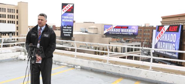
Attached (photo above) is a
photo of our Hennepin County EM (Eric Waage) at this mornings press
release, with "test" Tornado Warning on 3 different billboards in
downtown Minneapolis."
* This is a promising
development. As I've been saying for years, the more sources of
critical, time-sensitive information, especially tornado warnings, the
greater the odds you'll get the potentially life-saving nugget of
information in time to do something about it. That means NOAA Weather
Radio, local TV and radio, sirens, apps on smart phones, Internet e-mail
alerts, and now "smart billboards".
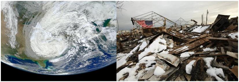
East Coast Rebuilding, But Vulnerable To Future Sandy's. Here's a clip from
Live Science: "
In
the aftermath of Superstorm Sandy, local governments are rethinking
how to best protect the U.S. coastline from storms and flooding, which
appear likely to exert a larger toll as the result of sea level rise
and climate change. The coast is now much less protected for the next
storm, because Sandy's storm surge
and winds destroyed dunes, flood walls and other barriers, said Joe
Vietri, director of coastal and storm risk management for the U.S. Army
Corps of Engineers, at a news conference here today (April 17)..."
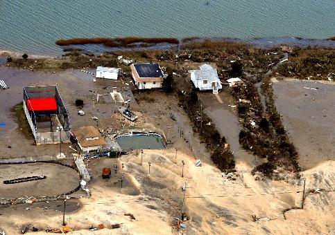
Photo credit above: "
Coastal damage caused by Hurricane Sandy". U.S. Geological Society.
Weather Training Organization In Jeopardy After Weather Service Cuts. Details from
The Capital Weather Gang; here's an excerpt: "
The
nation’s leading online training program for meteorologists is
pleading for a cash infusion from users in the wake of government
spending cuts that threaten its survival. The program, known as COMET,
provides online training courses to more than 275,000 meteorologists,
pilots, emergency managers, other professionals, and students according
to its parent organization, the University Corporation for Atmospheric
Research (UCAR), COMET’s director, Dr. Rich Jeffries, said the program
has a $2 million deficit due to the recent cuts, which have come
primarily from NOAA’s National Weather Service but also from Department
of Defense and overseas partners. The National Weather Service,
COMET’s main funder, has been forced to reduce spending due to its own
budget woes. Yesterday, it announced a plan to furlough employees for 4 days as a cost savings measure..."
"Miracle Of The Robins". After the tragedy in
Boston, and the drip-drip of less than pleasant weather news in recent
weeks, it was a nice change of pace to get this
YouTube video, showing an estimated 100 robins descending on one yard, according to Patricia Keiper: "
I have
100% proof that spring is here. How does a hundred American Robins in
one place grab you? LOL. They appeared in my backyard courtyard on Tax
Day." Patricia, I hope it's a good omen of warm fronts to come...
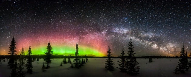
Celestial Magic.
I've seen a lot of great photos (and I want to thank everyone who has
taken the time and effort to forward me a photo or video - I take
nothing for granted). But this one took my breath away, courtesy of
Steve Burns, who captured the Northern Lights and the Milky Way up at
Voyageur National Park last weekend. He earned this photo, camping out
in subzero weather to get the money shot: "This was taken about 3 am
on Sunday morning as the galactic center of the Milky Way was rising to
the east and the aurora was dancing to the north. It's a 180-degree
stitch of 7 vertical captures from northwest to southeast. The light
pollution at the very left is International Falls and on the far right
is Ely. The aurora is a little over-exposed, but I wanted 30 second
exposures for each shot to maintain consistency and really bring out the
stars and foreground." Mission accomplished Steve. Great work.
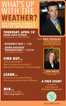
Environmental Commission Hosting Climate Change Discussion Thursday Night.
I'm looking forward to spending some time in Edina, joined by Fresh
Energy Scientist J. Drake Hamilton (who will talk about solutions, and
ways to save money by shrinking your carbon footprint. Details from
Edina Patch: "
Local Meteorologist Paul Douglas
will be on hand Thursday night, April 18, as Edina's Energy &
Environment Commission hosts a discussion about climate change at Edina High School.
The event is scheduled to begin at 6 p.m., with a resource fair
outside of EHS' Fick Auditorium. Following that, a presentation titled
"What's Up with the Weather?" will run from 7-8:30 p.m. Douglas and J.
Drake Hamilton, science policy director for Fresh Energy, will lead
the discussion, explaining what normal weather patterns are and what
science is currently indicating. “Attendees will walk away with a
broader understanding of what science is telling us about climate
change and what they can do to help reduce their carbon footprint,”
said City of Edina Environmental Engineer Ross Bintner. “There are many
things we can do that can help make a difference...”
Hawaiian Shirt Friday. Hey, it isn't every day you
get to give a speech wearing a Hawaiian shirt. Last Friday I gave a
presentation on disruption, reinvention, and my crazy business
experience over the years at Century College in White Bear Lake. To warm
things up attendees were encouraged to wear (bad) shirts. Hey, it
helped. Thanks to the amazing support staff and students at Century - I
appreciate your hospitality!
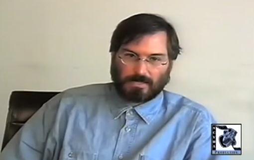
"If You're Afraid Of Failing...You Won't Get Very Far" The immortal words of Apple Founder Steve Jobs. Some words of wisdom for all of us in this classic video clip courtesy of
Business Insider: "
This YouTube video of Steve Jobs
is making the rounds again and for good reason. It's less than two
minutes long and it encapsulates one of the best bits of advice Steve
Jobs ever offered on how to succeed. In it, he tells of the story of
being a 12-year-old kid who picked up the phone and called legendary
tech founder Bill Hewlett
to ask him for spare parts. Hewlett wound up giving him a job and
that's where Jobs became friends with Woz and the inklings of Apple were
born. It's from an interview Jobs did in 1994."
What Will The World Look Like In 50 Years? It's a
tough question to answer. We all hope that things will be better for our
kids and grandkids. Sustainable growth, ways to grow the economy and
empower (and feed) people worldwide, while respecting the environment.
Tapping neural networks and crowd-sourcing to tackle emerging problems.
It's in our DNA to focus on today, what's in front of us - we have a
much harder time reimagining the future. Here's a video clip from
ashoka.org that may just get the gears cranking:
Editor's note: This is an update from Ashoka at the Skoll World Forum. This post was originally found on Forbes and was written by Felicity McLean, the communications manager at Ashoka UK. In
our world of both exponential growth and accelerating innovation,
systems of repetition are “doomed to collapse.” We need to make radical
changes to the frameworks in which we operate. The world is now an
interconnected neural network, where problems are considered shared and
where solutions are crowdsourced—we’re no longer living in silos. This
power of connection has begun—and will continue—to reveal what we are
capable of. We must work together to redefine what “growth” and
“development” really mean..."
Wow Lense For iPhone Puts More Lenses Within Easy Reach. Attention iPhone fans - here's a gadget that may sharpen up your next photos, courtesy of
gizmag.com: "
The
iPhone comes with a competent camera out of the box, but it could be
better. We've seen a set of the third-party lenses called the iPhone Lens Dial
that provides all kinds of creativity options for photographers, but
it's a little on the large side, and probably not something you would
want to have on your phone all the time. The WoW Lens features a similar
design, but it's quite a bit smaller and much more likely to remain on
the iPhone even when not in use..."
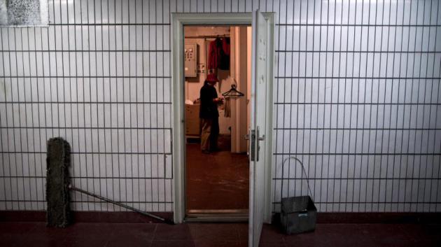
In Beijing Housing Is So Expensive That Migrant Workers Are Living In Bomb Shelters. Here's an excerpt of an eye-opening story at
Quartz: "
The
numbers are undeniably mind-boggling: An estimated two million people
in Beijing are said to be living below the earth’s surface, in
thousands of 100-square-foot spaces located just one or two stories
below street level. These figures have been making headlines (and
trending upwards) for a couple of years now. Assuming they’re
accurate, that would mean 10 percent of the city’s 20 million people
sleep in windowless, subterranean residences. That they are there
speaks to the crushingly expensive housing market in
China’s bulging top-tier cities. The makeshift conversion of
approximately 20,000 antiquated bomb shelters and basements across
Beijing has also no doubt led to a rise in dangerous living conditions:
it’s common to find multiple people sharing these small emergency
shelters made only slightly more hospitable with space heaters and hot
plates..."
Photo credit above: "
As many as 2 million people live underground in Beijing." AP Photo/Andy Wong.
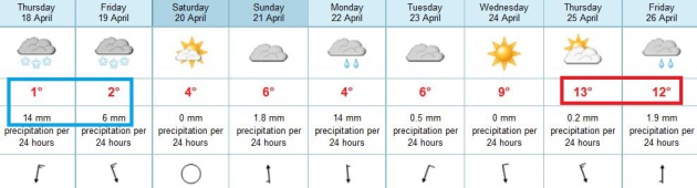
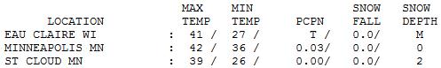
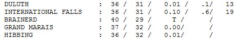
Wednesday Numbers. Under a drab, gray sky highs
yesterday ranged from 36 at Duluth (13" snow on the ground) to 39 at St.
Cloud (2" snow left) and 42 in the Twin Cities. Hope you enjoyed the
warm front.
TODAY: Winter Storm Warning. Rain, ice and sleet mixes with snow. Mainly wet roads, but some slush on lawns and fields. Winds: NE 15-25+ High: 38
THURSDAY NIGHT: Winter Storm Warning. All snow, with 3-6" in the metro by morning, maybe more northern and western suburbs. Low: 30
FRIDAY: Snow tapers early. A slow, slushy AM Rush Hour. Clouds linger, but the drive home should be wet. High: 37
SATURDAY: Partly sunny, melting snow. Wake-up: 25. High: 43
SUNDAY: Few rain showers. Soggy. Wake-up: 33. High: 47
MONDAY: Periods of light rain. Wake-up: 36. High: 43
TUESDAY: Gray start, then slow clearing. Wake-up: 31. High: 47
WEDNESDAY: Partly sunny, a bit milder. Wake-up: 33. High: near 50
Climate Stories....
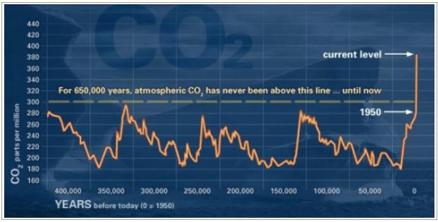
The "Hockey Stick" Slaps Back. Here's an excerpt of a very informative post summarizing recent papers and trends from
skepticblog.org: "...
STILL
not convinced? Then we will go even further back in time, to the
EPICA-1 ice cores in Antarctica (Siegenthaler et al., 2005), which
drilled back over 680,000 years into the past. This
core recovered air samples from trapped gas bubbles that gives us an
isotopic and carbon dioxide record through the past 6 or 7
glacial-interglacial cycles (each lasting about 110,000 years, and due
to the Milankovitch orbital eccentricity cycle that has been well known
for decades). As these records show, at no time during any of the
previous interglacial cycles did the atmospheric carbon dioxide level
exceed 300 ppm, even at the warmest part—yet our planet is well above
350 ppm today, and shooting rapidly to 400 ppm in a few years and
possibly to 600 ppm before the end of the century. THAT is not natural “climate variability” by any stretch of the imagination!..."
Global Warming Affects Seasonal Rainfall Patterns. Here's the intro to a review of a recent research paper at
bizcommunity.com: "
Two
mechanisms have been found to complement each other and together shape
the spatial distribution of seasonal rainfall in the tropics,
according to the study by a group of Chinese and Hawaii scientists
published in the 14 April 2013 online issue of Nature Geoscience. The
one mechanism, called "wet-gets-wetter", predicts that rainfall should
increase in regions that already have much rain, with a tendency for
dry regions to get dryer. The second mechanism, called the
"warmer-gets-wetter", predicts rainfall should increase in regions where
sea surface temperature rises above the tropical average warming..."
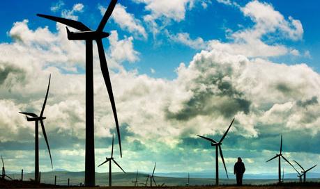
Clean Energy Progress Too Slow To Limit Global Warming, Warns IEA.
The Guardian has details: "
The development of low-carbon energy is progressing too slowly to limit global warming, the International Energy Agency (IEA) said on Wednesday.
With power generation still dominated by coal and governments failing
to increase investment in clean energy, top climate scientists have
said that the target of keeping the global temperature rise to less
than 2C this century is slipping out of reach.
"The drive to clean up the world's energy system has stalled," said
Maria van der Hoeven, the IEA's executive director, at the launch of
the agency's report on clean energy progress..."
Photo credit above: "
The development of low-carbon energy
is progressing too slowly to limit global warming, the International
Energy Agency (IEA) said." Photograph: Murdo Macleod
Liberal Senator To Activists: Make Climate Change Like Immigration, Gay Rights. Here's an excerpt of a story at
The Hill: "...
I
think there is a shift at the state level,” he said, noting
participation of some GOP governors in climate initiatives and that
governors also “see the value of green energy in their states.” “I think
there is a latent movement within the Republican power structure,”
Whiethouse said. “The real question is, if you are concerned about the
future of the Republican Party, do you want to have the image of that
party, as this generation grows up, to be that they were the party that
stopped and opposed action on what likely will be the most important
issue in these kids’ lives, and did so on the basis of a lot of
propaganda and lies from the polluting industry. That is a narrative
that can’t be good for the party,” Whitehouse said..."
EarthTalk: 4-Step Plan For U.S. To Ease Global Warming. Here's an excerpt from the NRDC and
WestportNews: "...
Step
1 is to cut global warming pollution via "strong legislation that caps
carbon emissions and makes polluters pay for the global warming gases
they produce." Step 2 involves investing more in green jobs and clean
energy. Producing more fuel efficient cars constitutes Step 3. Creating
green homes and buildings is Step 4. Step 5: Build more sustainable
communities and transportation networks. Individuals need to play a
role, too, by altering our behaviors to reduce our individual carbon
footprints. NRDC has several suggestions along these lines as well.
Walking, biking or using public transit instead of driving is one. If
you must drive, make sure for best gas mileage that your car is tuned
and your tires are properly inflated. If in need of a new car, look
into a hybrid or electric that consumes less or no gasoline..."
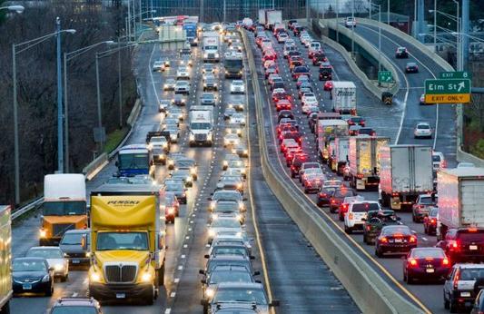
Photo credit above: "
Building sustainable transportation
systems that would reduce scenes like traffic-clogged I-95, is one of
the steps to reducing the greenhouse gases that are fueling global
warming." Photo: Keelin Daly
"Climate Has Always Changed". That's a true
statement, but now, for the first time, man is impacting, in a
significant way, the chemistry of the atmosphere, by burning fossil
fuels and releasing greenhouse gases into the atmosphere. Here is a good
response to the "hey, climate has always changed!" meme, from veteran
Denver TV meteorologist Mike Nelson, at
The Yale Forum On Climate Change And The Media: "...
It
is absolutely true that the Earth’s climate has cycled through great
changes over the course of our geologic history. These changes are
obvious in the fossil record — my home town area of Denver was once
under a great shallow ocean. These changes result from a variety of
causes, from volcanoes to continental drift to the shift in Earth’s
orbit on its journey around the Sun, to changes in the output of energy
from the Sun. One of the key components to our Ice Ages has been what
are called Milankovitch Cycles. These long-term changes in the shape
of our orbit and the shift in the tilt of the Earth work like the
complex gears of a clock, gradually switching our planet from Ice Age
to warmer periods and back again. The Milankovitch Cycles
are well documented and have been a primary driver of our changing
climate for hundreds of thousands to millions of years. Now, for the
first time in the Earth’s history, there is evidence that these gears
may be impacted by changes in the atmospheric chemistry — changes that
are being caused by human activity..."
U.S. Needs A Better Disaster Plan. Here's an excerpt of an Op-Ed at
The Los Angeles Times that resonated: "...
Natural
disasters have become increasingly costly to the United States, both
in terms of the toll they take on American communities and in the
direct costs of mounting a federal response. The federal government
spent about $150 billion on relief efforts after Hurricane Katrina, and
has so far committed about $60 billion for Superstorm Sandy.
The best estimate going forward is that the federal government will
spend in the neighborhood of $50 billion a year (in constant dollars)
on natural disasters, up from less than $10 billion a decade ago. What
accounts for this increase? In the words of environmental geographer
Gilbert White, "Floods are acts of God, but flood losses are largely
acts of man." Although climate change may be making the occurrence of
major storms and floods more frequent, poor planning and bad
development decisions are making disasters more expensive..."


No comments:
Post a Comment