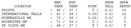
72 F. high in the Twin Cities Saturday.
63 F. average high on April 26.
56 F. high on April 26, 2012.
31.7" snow in the metro area since March 1.
3 days of 70+ temperatures? The last time that happened was October 1-3, 2012.
Welcome Spring Fling
Minnesotans EARN their springs. 2013 could be a
poster child for crazy extremes: from 5-inch snows to 70s in 4 days?
Impressive. Time to clean up the yard, drag out the lawn chairs, remove
stubborn doggy deposits and banish my coats and long johns to cold
storage.
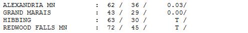
The icing on the cake? I may rest my 21 foot Malibu on the surface of my icy lake....and try to be patient.
With highs over 70 today, Sunday and Tuesday ice
should break up on metro lakes next week. I can only hope Governor
Dayton enjoys ice fishing - I'm not at all convinced ice will be off the
Park Rapids Lakes by May 9.
Always have a viable Plan B, right?
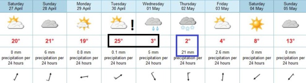
Today will be the day you've been day-dreaming
about since November: blue sky, 71-74F, a gentle southwest breeze, no
humidity, few bugs & allergies under control. About as good as it
gets.
A weak cool front ignites T-storms by Sunday
night but most of the weekend looks dry. A warm front surges north
Tuesday; highs near 80F. Soak it all up because a temperature tumble
arrives midweek; 40s by Wednesday.
Expect shorts, t-shirts & random convertible sightings this weekend, but keep a heavy jacket handy.
I almost forgot: the ECMWF hints at rain by Wednesday - mixing with wet snow next Thursday.
I'm not joking.
Warm Into Tuesday, Then Another March-like Slap?
Expect low to mid 70s today, a bit warmer Sunday, highs may reach 75-80F
on Tuesday before dropping off a cliff by Wednesday behind a vigorous
cold front. A blocking pattern causes next week's storm to stall, a
southern surge of moisture may produce rain changing to wet snow next
Thursday - although it's way too early for specifics. Some improvement
is likely by next weekend. Deep breaths.
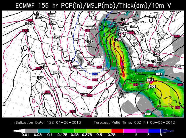
A Very Un-Maylike Weather Map. The ECMWF model map
valid next Thursday evening shows another surge of chilly, Canadian air
stalling over the Plains, pulling Gulf moisture right up the Mississippi
River Valley into Minnesota and Wisconsin. There may be enough cold air
in place for rain mixing with or changing to some wet snow by late
Thursday or Thursday night. Timing and amounts are very much up in the
air. The "Euro" also shows an unusually strong storm over Florida,
forecast to churn up into the Carolinas with heavy rains, high winds and
possible coastal flooding. Odd for early May. Map: WSI.
Back On Track. After a possible wintry relapse late
next week the GFS shows slow moderation next weekend, 60s returning just
in time for the 2013 Fishing Opener. Ice will be off most lakes from
the metro to Mille Lacs by then, but Park Rapids and northern lakes?
Probably not. Ice fishing anyone?
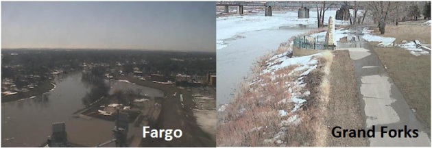
Tracking The Rising Red River. Click here to see a live webcam from Fargo, courtesy of the City of Fargo. USGS has a webcam in the Grand Forks area
available here.
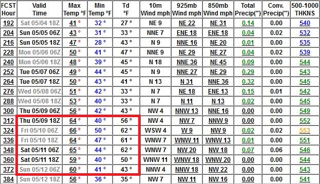
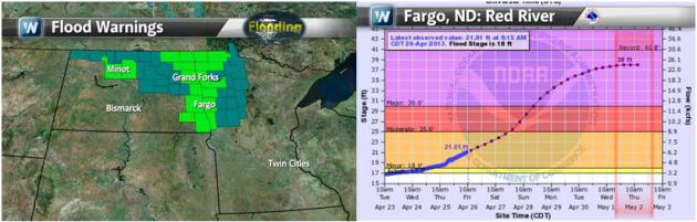
Watching The Red River Carefully. Flood Warnings are
posted for the Red River now, a Flood Watch for northwestern Minnesota
and northeastern North Dakota for rapidly melting snow and ice dams
causing sudden rises in streams and rivers. The NOAA forecast for Fargo
(upper right) shows a crest near 38 feet next Thursday, just 2 feet shy
of the all-time record set in 2009.
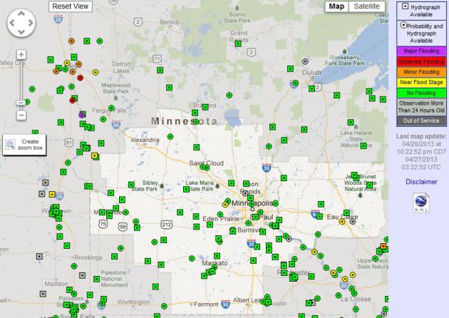
Latest Flood Conditions. NOAA has a
slick interface
that allows you to see, at a glance, which streams and rivers are near
or above flood stage - click on the individual marker and you get
details; a prediction of when the river will crest, and how high.
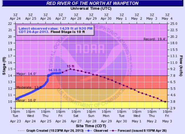
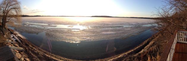
Major Flooding At Wahpeton. The Red River is
forecast to crest in Wahpeton later today, about 1 foot above major
flood stage, but well shy of the previous record of 19.4 feet. Source:
NOAA.
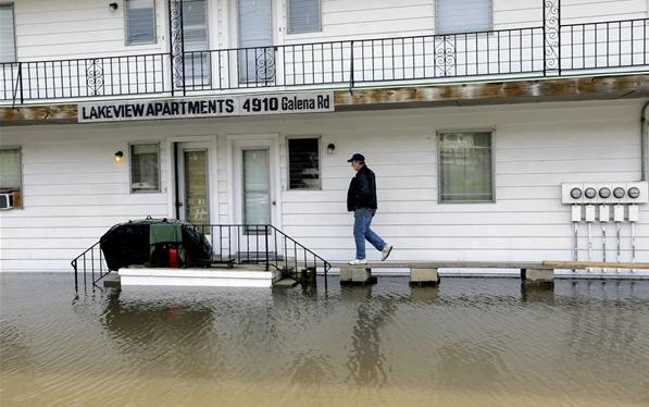
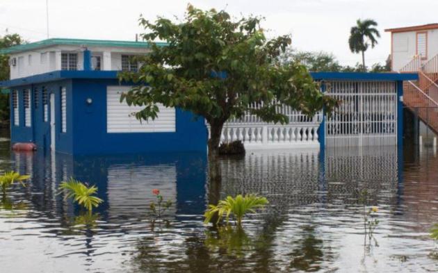
Effects Of Midwest Flooding Will Be Felt For Months.
NBC News
has a good overview of the problems, including a wild swing from not
enough water in the Mississippi River a couple months ago to severe
flooding in recent days; here's an excerpt: "...
To the north, a
damaged lock may keep a stretch of the Illinois River closed to
commercial shipping traffic for weeks, the U.S. Army Corps of Engineers
said. Flooding has halted the transport of corn and soybean barges at
certain terminals on the river, Reuters reports. The disruptions could
cause significant disruptions in the flow of grain and corn in the
second-highest soybean producing state. Reuters reports almost 60
percent of U.S. grain exports are transported on the Mississippi River
and its tributaries. Grain prices at export terminals at the Gulf of
Mexico climbed this week to the highest level in at least a month due
to the disruptions..."
Photo credit: Seth Perlman / AP. "
Steve Peters uses a
make shift bridge to access dry land in Peoria Heights, Ill. The
Illinois River crested at 29.35 feet, eclipsing a 70-year record in
Peoria."
Up To 375 Flood Gauges To Turn Off Because Of Fund Cuts. Doyle Rice from
USA Today has a head-shaking story, another victim of "The Sequester". Coming at a good time huh? Here's an excerpt: "
Just
in time for the spring flood season, the federal sequester is
threatening to shut off funding for hundreds of stream gauges used by
the U.S. Geological Survey to predict and monitor flood levels across
the country. "The USGS will discontinue operation of up to 375 stream
gauges nationwide due to budget cuts as a result of sequestration," the
USGS notes on its website. Additional stream gauges may be affected if
USGS partners at state and local agencies reduce their funding
support..."
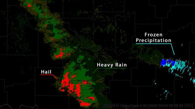
NOAA's National Weather Service Completes Doppler Radar Upgrades.
New "dual-pol" Doppler upgrades do a better job calculating
precipitation types and rainfall and snowfall amounts - so sensitive
they can even detect the debris signature from a tornado on the ground.
More details from
NOAA: "
This week, the National Weather Service
completed the dual-polarization technology update in Brownsville,
Texas – concluding the 122 NWS radar site upgrades throughout the
country. This new advanced technology is helping federal weather
forecasters more accurately track, assess and warn the public of
approaching high-impact weather. Dual-polarization
is the most significant enhancement made to the nation’s federal
weather radar system since Doppler technology was first installed in
the early 1990s. Dual-pol radar sends and receives both horizontal and
vertical pulses, which produces a much more informative picture of the
size and shape of the objects in the sky. This provides
meteorologists the ability to distinguish between rain, snow, hail and
non-weather items like wildfire smoke plumes, birds and insects.
Conventional Doppler radar only has a one-dimensional view making it
difficult to tell the type of precipitation or object in the sky..."
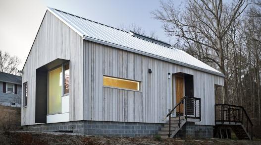
In Pictures: Top 10 Greenest Buildings In the U.S. Here's a clip from an interesting story at
gizmag.com: "
The
American Institute of Architects announced its top ten green buildings
in the US for 2013 on Monday (Earth Day, uncoincidentally). It's a
diverse list, containing a cheese factory, senior citizens' apartments,
school buildings, and a smattering of LEED certificates. There's only
one net zero building on the list, though it's worth remembering that
it's much easier to build a net zero home than it is a net zero office
or factory. Step inside for a short profile of each of the buildings,
or head straight to the gallery for the architectural eye candy..."
Photo credit: "
A New Norris House: perhaps the most modest building in the AIA's top ten " (Photo: Ken McCown).
Least Stressful States In The USA? Minnesota didn't
make the Top 10 Stressful states, and it didn't make the Bottom 10 (most
stressful states). Want less stress? Move to Iowa. Hawaii I get, but
Iowa? Here's an excerpt from an article at
gallup.com:
WASHINGTON, D.C. -- Hawaii residents remained the least likely in the
U.S. to say they felt stressed on any given day in 2012, at 32.1%.
West Virginia residents, on average, were the most likely to report
feeling stress, at 47.1%.
Power Of A Late-April Sun. In
spite of 15" snow on the ground Duluth saw a high of 62F on Friday.
Pretty impressive. Elsewhere highs ranged from 43F at Grand Marais (cold
wind off Lake Superior) to 69 St. Cloud and 72 in the Twin Cities and
Redwood Falls. Finally, spring.
TODAY: Lukewarm sun. Close to perfect. Winds: S 10+. High: 73
SATURDAY NIGHT: Mostly clear. Low: 51
SUNDAY: Warm sun, chance of thunder by evening. High: 77
SUNDAY NIGHT: Better chance of a few showers and T-showers. Low: 50
MONDAY: Plenty of sun, a bit cooler, but still pleasant. High: 69
TUESDAY: Warm sun, isolated T-shower. Wake-up: 54. High: 78
WEDNESDAY: Colder, periods of light rain. Wake-up: 45. High: 47
THURSDAY: Just the messenger. Rain changes to wet snow. Slush? Wake-up: 34. High: near 40
FRIDAY: Mostly cloudy, still chilly. Wake-up: 32. High: 43
Climate Stories...
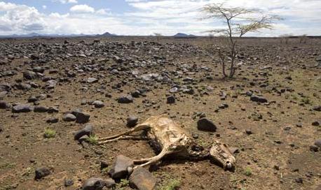
The Drought-Stricken Midwest's Floods: Is This What Climate Change Looks Like? Here'san excerpt from a story at
The Atlantic Wire: "...
In other words, a warmer atmosphere from climate change likely yields greater extremes in weather. This syncs with the draft report issued
by the government's National Climate Assessment Development Advisory
Committee last year. That report predicted the following for the
Midwest: "longer growing seasons and rising carbon dioxide levels will
increase yields of some crops, though those benefits will be
increasingly offset by the occurrence of extreme events such as heat
waves, droughts, and floods." That prediction was meant to be borne out
over the next several decades. What it predicted, though, has already
been seen over the course of six months..." (photo: AP).
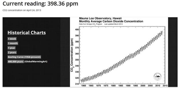
As CO2 Concentrations Near Ominous Benchmark, Daily Updates Begin.
Scientific American has the story - here's an excerpt: "...
Scientist
Ralph Keeling wants this generation to remember when atmospheric
concentrations of carbon dioxide reached 400 parts per million, because
of humans. "I hope that many people out there in the decades to come
will say, 'Gosh, I will remember when it crossed 400,'" he said. That's
why Keeling and his employer, the Scripps Institution of Oceanography at the University of California, San Diego, have launched a website that will provide daily updates on atmospheric CO2 concentrations, measured at Hawaii's Mauna Loa Observatory..."
Graphic credit above: 398.36 ppm. The very latest CO2 concentrations can be found at
The Keeling Curve web site, operated by Scripps Institution of Oceanography.
CO2 On Trial: If Things Had Worked Out Better.
Here's an excerpt of an important article, an explanation of how climate
science has been turned into a perverse mock "trial". Michael Tobis
argues that we need to grow up, and recognize our limits in this story
at
medium.com: "...
The
fact is that we are entering an age of new and unprecedented limits.
We can still have a happy future, human achievement and human dignity
can continue its broad historical progress, and we can still have a lot
of fun. But we have to recognize new limitations. The emergence of
limits is unfortunate. It's costly. It's ill-timed. But preserving a
stable environment is an ethical responsibility like none that has
preceded it. We need people to understand not only that CO2 is a global
problem, but that it's just the first in a series, as we make the
transition from an open frontier world to spaceship earth. As a brand
of soap, this is a hard sell. We have to sell the idea of a widespread
set of changes in behavior, a new set of ethical constraints, and a
substantial increase in the complexity and scale of governance. There
are serious risks and costs involved, but avoiding this responsibility
will yield something much worse..."
Global Warming Accelerated Last 15 Years. Here's an excerpt from Doug Craig's terrific
Climate of Change blog at Redding.com: "...
And
a new study of ocean warming published last month in Geophysical
Research Letters by Balmaseda, Trenberth, and Källén reached several
conclusions:
• Completely contrary to the popular contrarian myth, global
warming has accelerated, with more overall global warming in the past
15 years than the prior 15 years. This is because about 90% of overall
global warming goes into heating the oceans, and the oceans have been
warming dramatically.
• As suspected, much of the 'missing heat' Kevin Trenberth
previously talked about has been found in the deep oceans. Consistent
with the results of Nuccitelli et al. (2012), this study finds that 30%
of the ocean warming over the past decade has occurred in the deeper
oceans below 700 meters, which they note is unprecedented over at least
the past half century..."
Obama Campaign Launches Campaign To Shame Climate Skeptics In Congress. Here's the intro from a story at
The Guardian: "
The campaign group formed to support Barack Obama's political agenda has launched an initiative to shame members of Congress who deny the science behind climate change.
In an email to supporters on Thursday, Organizing for Action said it
was time to call out members of Congress who deny the existence of
climate change, saying they had blocked efforts to avoid its most
catastrophic consequences. The email linked to a video
mocking Republicans who reject the science on climate change. "Right
now, way too many lawmakers in Washington flat-out refuse to face the
facts when it comes to climate change," Jon Carson, executive director
of Organizing for Action wrote in the email. "We're never going to make
real progress on this issue unless members of Congress get serious..."
Photo credit above: "
The campaign suggests climate change has emerged as a serious issue for Obama to pursue in his second term." Photograph: Gideon Mendel/Corbis.


No comments:
Post a Comment