21 F. low Saturday morning, a new record low (first record low for MSP since August, 2004). Old record: 26F in 1888.
42 F. high yesterday in the Twin Cities.
60 F. average high on April 20.
58 F. high on April 20, 2012.
5" snow on the ground at KMSP.
.25" rain today (NAM model).
Coating to 2" slushy snow possible Monday PM hours.
60s to near 70F by next weekend?
Beyond Cabin Fever
Hi. I'll be your weather therapist today. "Dr.
Douglas - I can't sleep. I'm anxious, irritable & moody. I dream of
glaciers coming down my driveway. I read your 7-Day Outlook and want to
hurl. Help me."
Hang on Dear Reader. My forecast of a
"light-switch spring" may come true: ankle-deep in slush - with chirping
birds & tornado sirens.
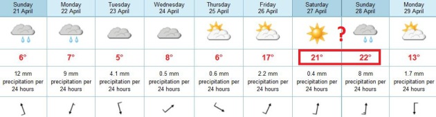
We may top 70F next weekend, based on ECMWF
guidance. A rain/snow mix tomorrow evening - but temperatures boomerang
to near 70F by Saturday afternoon, maybe even a few severe T-storms late
Sunday? Something for the entire family. The extremes just keep getting
more extreme. How this long overdue temperature spike will impact the
1-3 FEET of snow up north and a potential for major river flooding is
unknown, but this can't be good news for the Red River at Fargo.
Historic flooding in Chicago may be an omen of muddy torrents to come. No, the transition to summer will not be painless.
21F low yesterday in the cities; the first
record low since 2004 in the metro area. The sun is as high in the sky
as it is in late August. You can get a sunburn now shoveling snow.
Amazing.
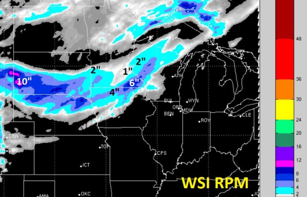
Rain today gives way to a slushy mix Monday
night; 1-3" possible south of MSP. A little slush is possible on lawns
and fields in the metro Monday night - right now it does NOT look like a
rerun of last week.
Some anglers are still ice-fishing up on Pelican
Lake. It was such a jarring sight that I had to stop and take pictures.
Even the old timers are shaking their heads in wonder.
It almost makes me wonder what's coming next?
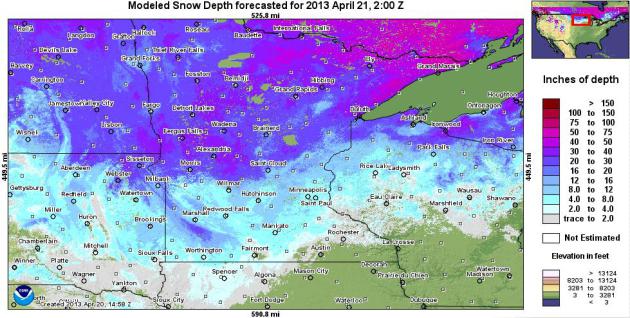
Heaps And Piles Of Snow. I'm north of Brainerd,
staring out my window at a good 2 to 2.5 feet of snow, with numerous 3
to 4 foot drifts - wondering when on Earth this is going to melt. The
heaviest (16-30") amounts are north and west of St. Cloud, as much as
40-50" still on the ground over Lake Superior's North Shore. Two months
from the Summer Solstice. Map above: NOAA.
Not Again. Today's rain gives way to a cooler front
Monday, setting the stage for a wave of low pressure to ripple east -
enough chilly air in place for a period of slushy snow by Monday night,
mainly south/east of MSP. A close call, and a coating to 1" of slush
can't be ruled out on some lawns and fields, greater amounts south/east
of the Twin Cities.
Light-Switch Spring? My confidence level is low,
because models have been so erratic as of late (in response to huge
extremes in temperature and moisture). But the ECMWF shows a chilly
start to the week giving way to 60s, even a chance of 70s by next
weekend. By then most of the snow should be gone, at least in the metro
area. Once the snow has melted the sun's energy can go into heating up
the air. Yes, a rare care of Spring Fever may be 6-7 days away.
Cautious Optimism. The flow has been relentlessly
northwest - ever since February. But that may change by the end of the
week as the core of chilly air shifts into New England, allowing winds
at all levels of the atmosphere to turn to the southwest, tugging mild
air north. 60s to near 70 by Saturday? A distinct and growing
possibility. ECMWF model map above from WSI valid Saturday evening.
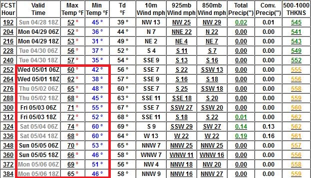
Turning A Big Corner. A very strongly negative phase
of the AO (Arctic Oscillation) has kept unseasonably cold air stalled
over much of Canada and the Upper Mississippi Valley and Northern Plains
for much of the last 2-3 months; a pattern which finally shows signs of
breaking down in the coming weeks. By early May we should be
consistently in the 60s and 70s, according to the GFS. Say a silent
prayer or two the models are on the right track.
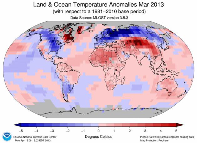
March 2013: Ties For 10th Warmest Worldwide. "Hey
Paul, where's your global warming now - it's cold outside!" Yes, I've
heard a lot of that in recent weeks. March was cold over many northern
tier states, and the unusual chill is spilling over into most of April.
But unless you can see the entire globe from your living room window you
have to take a wider view of what's going on, and rely on data from
NOAA NCDC (National Climatic Data Center); here's an excerpt: "...
The
globally-averaged temperature across the world's land and ocean
surfaces was 0.58°C (1.04°F) above the 20th century average of 12.7°C
(54.9°F), tying with 2006 as the 10th warmest March since records began
in 1880. Both the Northern and Southern Hemispheres were also 10th
warmest for March..."
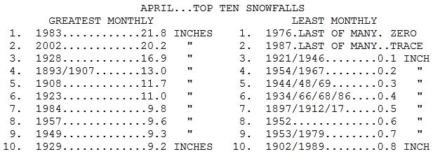
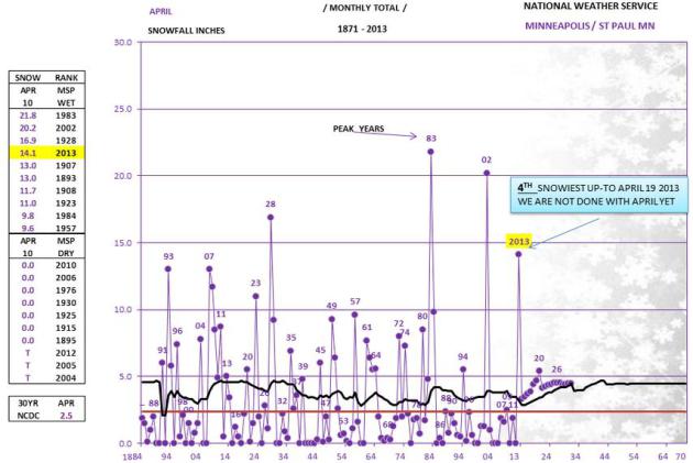
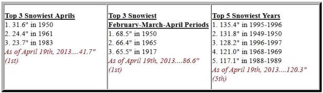
Snowiest Aprils In The Twin Cities? Welcome to the
4th snowiest April on record for the Twin Cities, with 14.1" so far. The
graphic above is from the Minnesota State Climate Office. April, 1983
is still the record for snow at MSP, with a whopping 21.8" of snow. More
details from the Twin Cities National Weather Service:
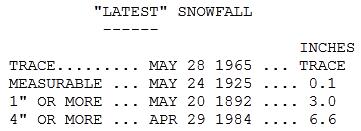
Paul - when was the latest significant snowfall (>3") in
the Twin Cities? With the way this winter is going, I feel the need to
prepare for the possibility of plowable snow in May. Has that actually
happened before?
Fiona Ruthven
Fiona - I found the information at the Minnesota State Climate Office. Fun weather factoids to annoy friends and loved ones:
Latest Snowfalls In The Twin Cities. No, we didn't
set a record for the latest 4"+ snow at MSP. That honor goes to April
29, 1984, when 6.6" of snow delighted residents of Minneapolis/St. Paul.
We've seen 3" snows as late as May 20 (1892). Rare, but possible.
Yikes.
Latest 60F In The Twin Cities? Minnesota State
Climatologist Greg Spoden provides some details on how unusual our
stunted spring really is. Bottom line: there have been only 7 years
since the 1870s with a "first 60F" after April 19. Lovely. "
The
average date of the first 60 degree temperature in the Twin Cities is
March 29. I suggest you avoid the word "typically" because the range of
dates is so large (February 15, 1921 to April 29, 1874). Here are the
only years where the Twin Cities had yet to reach 60 degrees as of
today's date (April 19)."
1874 April 29 (latest 60F high on record in the Twin Cities)
1904 April 26
1947 April 26
1951 April 25
1975 April 25
1965 April 21 (year of the EF-4 tornadoes that hit on May 6 in the Twin Cities)
1876 April 20
Snowiest April On Record For Duluth. And it was the
snowiest February - April period on record for Duluth as well, the 5th
snowiest winter season overall. Details from the
Duluth office of the National Weather Service.
Snowiest Winter Seasons In Duluth. At last report Duluth was (unofficially) up to 121.8", making it the 4th snowiest winter on record. Remarkable.
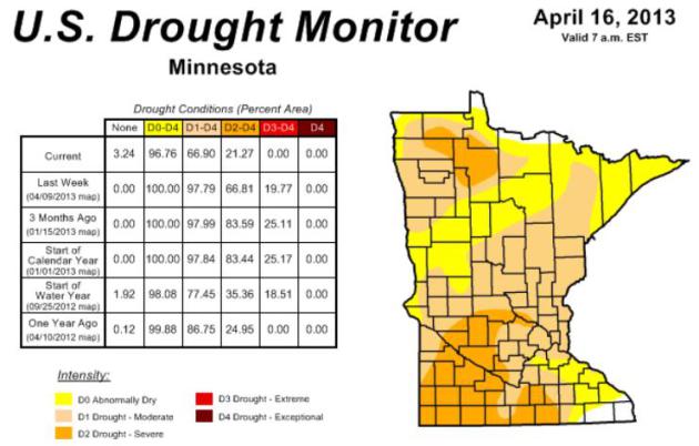
Storms Chip Away At Drought In Northern U.S. Last
week nearly 20% of Minnesota was in extreme drought. That has fallen to
0% as of this week; severe drought has dropped from 66% to 21% of the
state. The trends are encouraging, between heavy rain (and heavy snow).
Here's an excerpt from a story at
Climate Central: "
Two weeks of storms and a slowly melting snowpack in the northern U.S. continued to chip away
at the drought gripping the center of the country. But even as the
drought has contracted nationwide, parts of the Texas and the Southwest
have seen conditions deteriorate, and are likely to face another tough
summer of drought. The northern part of the U.S. saw the biggest gains,
which was welcome news for a region hit hard by drought for the past
year. Drought contracted significantly across Wisconsin, Minnesota,
Iowa, the Dakotas, and Wyoming, as two spring storms dropped heavy
precipitation on the region, and the winter’s snowpack began to
infiltrate the soil....
Areas of Minnesota and Wisconsin that had been under “moderate” drought were downgraded to “abnormally dry....”
* latest U.S. Drought Monitor for Minnesota is
here - data from NOAA and USDA.
Whiplash Spring. From flood to drought, and back to
flood (and record-setting April snows). It's been a volatile month, but
Gulf moisture is consistently reaching the Upper Midwest; drought
conditions are easing. In today's edition of
Climate Matters we take a look at jaw-dropping snowfall amounts, and offer up evidence that the drought's days may be numbered: "
Noticeable
improvement in the drought conditions this month for several Midwest
states including Nebraska, Iowa and Minnesota. Meteorologist Paul
Douglas has the silver lining to what's been a snow and rain filled
April."
Rains Wash Away U.S. Drought, Shifting Farm Economy's Prospects. Here's a snippet of a
Reuters article: "...
These
rains are really helping bring most areas out of drought status. And
the rain encompasses all of the western Corn Belt that was previously
dry," said Don Keeney, meteorologist for MDA Weather Services, a widely
followed commercial forecasting firm. If the drought is ending, it would represent a sea change for the farm economy,
where expectations for another dry summer had been baked in. Continued
rainy weather could further delay spring plantings, cause a sharp fall
in the price of farm commodities, and lower the cost of everything from hog feed to cereal ingredients. Lower feed prices would help livestock
and dairy producers, but soft grain prices could cut into farmers'
incomes and perhaps even cause farmland values to retreat from recent
record highs..."
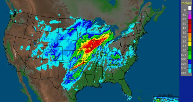
* Thursday 24-hour rainfall map from NOAA
here.
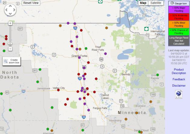
Experimental Long Range Flood Outlook. There's a
greater than 50% risk of major flooding on the Red River in the coming
weeks. The timing of the crest is still very difficult, ultimately
dependent on the rate of warming and any subsequent rain events into
early May. Right now NOAA is saying a greater than 50% probability of
minor flooding in the St. Cloud area.
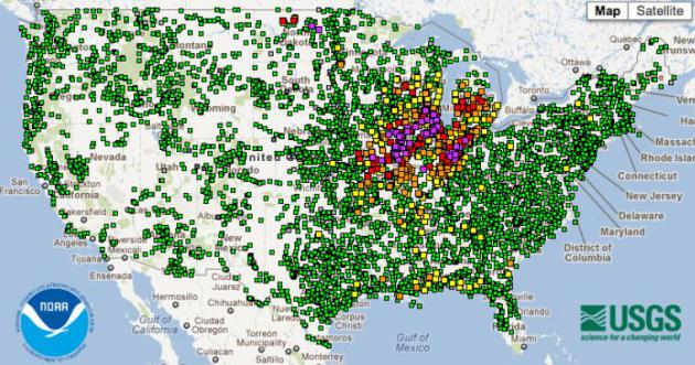
Flooding Underway Nationwide. USGS and NOAA update a
web site
that shows the status of flood conditions from coast to coast - big
problems from eastern Iowa into southern Wisconsin, Illinois and
Indiana.
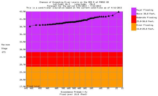
Fargo Flood Potential. This is an
experimental long-range prediction
for the Red River in Fargo, showing a 99% probability of a crest of at
least 38.7 feet, but the ultimate crest could go higher. River
hydrologists will be tracking melting snow (and temperature spikes and
additional rain) very carefully to try to pin down when, and how high.
Serious Weather Whiplash. A 1 in 60 year rainfall
event for parts of Iowa and Illinois? Dr. Jeff Masters underscores the
crazy swings in moisture the last couple of years: from record flood to
record drought, and now back to record, historic floods for parts of the
Midwest, Great Lakes, with implications along the Illinois and
Mississippi River. Here's an excerpt of his latest
Wunderground post: "
It
seems like just a few months ago barges were scraping bottom on the
Mississippi River, and the Army Corps of Engineers was blowing up rocks
on the bottom of the river to allow shipping to continue. Wait, it was
just a few months ago--less than four months ago! Water levels on the
Mississippi River at St. Louis bottomed out at -4.57' on January 1 of
2013, the 9th lowest water level since record keeping began in 1861,
and just 1.6' above the all-time low-water record set in 1940 (after
the great Dust Bowl drought of the 1930s.) But according to National Weather Service,
the exceptional April rains and snows over the Upper Mississippi River
watershed will drive the river by Tuesday to a height 45 feet higher
than on January 1. The latest forecast
calls for the river to hit 39.4' on Tuesday, which would be the 8th
greatest flood in history at St. Louis, where flood records date back to
1861. Damaging major flooding is expected along a 250-mile stretch of
the Mississippi from Quincy, Illinois to Thebes, Illinois next week...."
Graphic credit above: Wunderground.
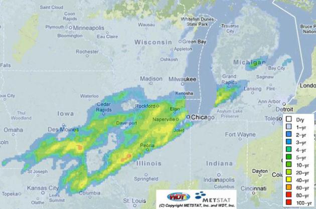
"The
rains that fell in a 24-hour period ending at 7 am EDT Thursday, April
18, 2013 over Northern Illinois were the type of rains one would
expect see fall only once every 40 years (yellow colors), according to METSTAT, Inc.
(http://www.metstat.com.) METSTAT computed the recurrence interval
statistics based on gauge-adjusted radar precipitation and frequency
estimates from NOAA Atlas 14 Volume 2, published in 2004
(http://dipper.nws.noaa.gov/hdsc/pfds/.) METSTAT does not supply their
precipitation recurrence interval forecasts or premium analysis products
for free, but anyone can monitor the real-time analysis (observed) at:
http://metstat.com/solutions/extreme-precipitation-index-analysis/"
What's Up With All The Robins? I have noticed an
unusual number of robins in my yard. Frankly, they look pissed.
Naturalist Kirk Mona takes a look at what's going on in this informative
story at
Minnpost.com; here's an excerpt: "...
Here's
the scoop. There are several factors at play. First off, we're doubled
up on robins. Our summer resident robins mostly move south in the
winter in search of food. Robins from further north, and I mean all the
way up into Canada, also moved south this winter. Some of them went
past the Twin Cities while some of them formed winter flocks and hung
out around open water and ornamental fruiting trees. The slow start to
spring and continued fowl weather including lots of snow up north has
put a halt to migration. Pretty much the entire Mississippi Flyway's
worth of robins are backed up in the Twin Cities right now. These are
resident birds mixed in with a sizable percentage of all the birds in
Canada. Like us, they are simply waiting for the weather to improve.
This is about as far north as they dare go at this point...."
Ask Paul. Weather-related Q&A:
I really enjoy your blog... I just looked up the
record data for this weekend and it looks like there is a good chance
we set a daily record low temperature on Saturday. When was the last we
had a daily record low temperature in the Twin Cities?
Marc Johnson
Plymouth, MN
Thanks Marc - appreciate you checking into the weather blog. You
brought up an excellent question, so I checked with my friend and
colleague, Pete Boulay, at the State Climate Office.
Turns out it's been 9 years since a record nighttime low! Details:
Hi Paul,
We tied a record low on September 15, 2011 of 36
degrees that was also set 2007 and 1964. The last time the Twin Cities
broke a record low was August 21, 2004 with 44 degrees. The last time we
broke a record low maximum temperature was June 23, 2011 with 63
degrees.
Pete Boulay, Minnesota State Climate Office
* update: the official low at MSP Saturday
morning was 21F, breaking the old record, the first record low for the
Twin Cities since 2004.
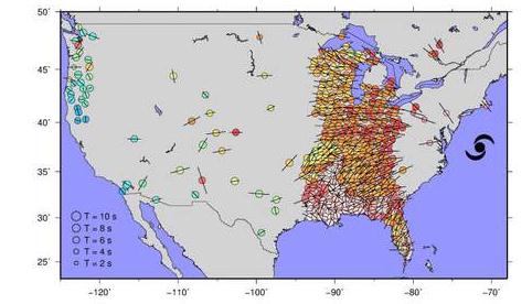
Superstorm Sandy Jolted Whole Of America. Here's an excerpt of a remarkable story at
Sky News: "
Earthquake
sensors located as far away as the Pacific Northwest detected the
storm's energy as it surged towards the New York metropolitan region
last year. The network typically records the sudden release of energy in
the Earth's crust, but it can pick up shaking triggered by ocean
waves, mine cave-ins and tornadoes. As Sandy lashed at New York City
and New Jersey, the force of waves slamming into other waves shook the
sea floor, which was recorded by the system of 500 sensors. The energy
generated by Sandy was similar to small earthquakes between magnitudes 2
and 3, seismologists at the University of Utah estimated..."
Graphic credit above: "
Image courtesy of Keith Koper, University of Utah Seismograph Stations."
Breaking News And Social Media: Stop Fighting It. I
was getting up to the second breaking news via Twitter Thursday night on
the unfolding situation in Boston, when the 24/7 cable news channels
were in taped programming. It's a great way to get breaking news - but
with speed sometimes come less than optimal accuracy. Here's an excerpt
of a post from
10,000 Words at mediabistro.com: "..
Of
course it's a fallacy to pit journalism and social media against each
other. They worth together. Not always well, but if it weren't for both
entities, neither one of them would be surviving right now. In the midst
of the fight, it's hard to remember that we're in the middle of a
watershed moment for both industries. This week, awash with bombings and
filibusters, the kinks in the system were brought to center-ring. It's
on the slower news days when everything works well. And that's something
to remember. Information spreads more quickly than it used to but, as
I'm sure or even Boston.com learned this week, that doesn't mean it has
to."
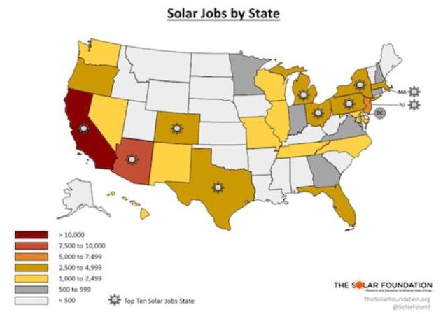
Fast-Growing U.S. Solar Industry Now Employs Over 119,000 - Lead By California, Arizona And New Jersey. New Jersey? Here's an excerpt of a story at
Think Progress: "...
Rhone Resch, president and CEO of the Solar Energy Industries Association explains:
Today, solar is one of the fastest-growing industries in the United
States, providing good-paying jobs for more than 119,000 American
workers. Over the past five years, the U.S. solar energy industry has
experienced sustained growth thanks to rising demand, falling costs and
new financing options. Since 2008, the amount of solar powering our
homes, businesses and military bases has increased six-fold–from 1,100
megawatts to more than 7,700 megawatts today, which is enough to power
more than 1.2 million American homes. Some of this growth is attributed
to the fact that the cost of a solar system has dropped by nearly 40
percent over the past two years, making solar more affordable than ever
for consumers. If we want to want to create new jobs, foster
innovation and ensure prosperity for future generations of Americans,
we must expand our commitment to using clean, renewable energy sources
in the U.S. and around the world..."
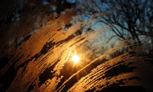
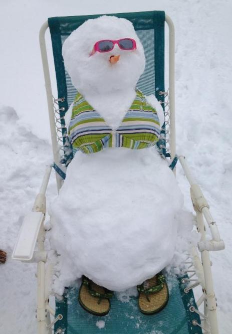
Gallows Humor. Yes, even the snowmen (and women) are
basking under a rarely visible April sun, trying to get a little tan
going. Thanks to Katie Deibele from Excelsior for sharing this.
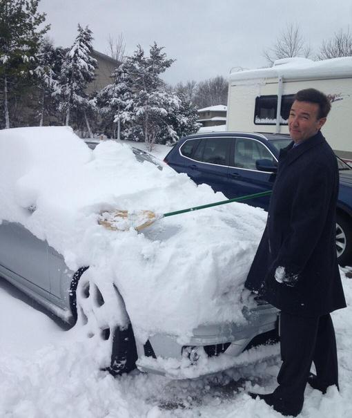
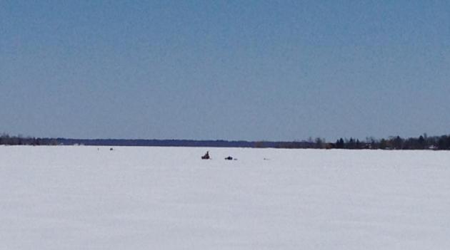
Ice Fishing - On April 20. The ice houses are long
gone, but anglers were out in full force yesterday. I stopped on 371
north of Brainerd, on Round Lake, and snapped this photo of ice fishing
yesterday afternoon. Surreal.
TODAY: Early slush, then rain showers. Winds: S 10-15. High: 49
SUNDAY NIGHT: Showers taper. Low: 37
MONDAY: Mostly cloudy with more rain developing. Rain may mix with snow by Monday night. High: 40
TUESDAY: Partial clearing, drying out. Wake-up: 33. High: 44
WEDNESDAY: Clouds increase, late shower. Wake-up: 32. High: 46
THURSDAY: Sun returns, turning milder. Wake-up: 35. High: 51
FRIDAY: Shower, then partly sunny, milder. Wake-up: 39. High: near 60
SATURDAY: Some sun, risk of a "warm front". Wake-up: 45. High: 69
Climate Stories...
Republicans Become More Concerned About Global Warming. Here's an excerpt from a story at
Mother Nature Network: "
Republicans
have become more concerned about climate change in the past couple of
years, according to a new Gallup Poll. Self-identified Republicans are
less likely than Democrats to say global warming concerns them, but
while Democrats' global warming anxiety
has remained relatively steady, Republicans' worry is climbing. In
2011, just 30 percent of Republicans said they worried a "great deal" or
"fair amount" about climate change. This year, that number reached 40
percent..."
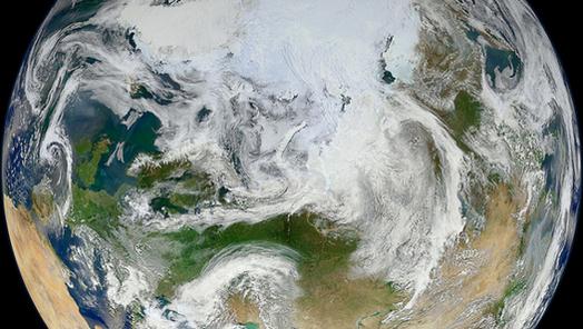
Image credit: "NASA/GSFC/Suomi NPP."
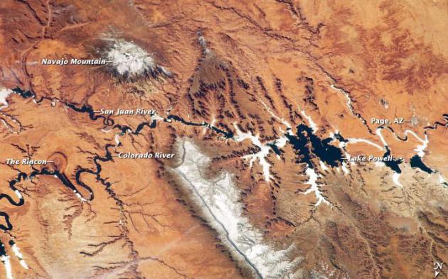
Is The Colorado River Damned? Op-Ed. Water, not oil,
will become the most precious natural resource later this century. The
Southwest is heading into another potentially very dry year - after the
4th driest winter on record for California. Here's an excerpt of an Op
Ed at
Live Science describing the water challenges for 2013 and beyond: "...
The
warming, drying climate of the Southwest is hitting the river hard. We
now know that drought is likely to be the new normal in the Colorado
River basin — scientists tell us that climate change could reduce the
amount of water in the Colorado River ecosystem by 9 to 20 percent.
Predictions of climate change and water usage draining the famed Lake Mead and Lake Powell dry
are a small, but real, part of that picture. This year is proving no
exception. Scientists with the National Oceanic and Atmospheric
Administration (NOAA) now say that the April through July inflow into
Lake Powell, the largest reservoir in the Upper Colorado Basin, will be
a mere 2.7 million acre-feet — the lowest amount since NOAA began
issuing forecasts in 1979. Combined inflows from this year and last
year's runoff seasons are likely to be the driest since Lake Powell
began filling in behind the Glen Canyon Dam in September 1969..."
Image credit" "
The Colorado River from space on March 12, 2013." NASA Earth Observatory.
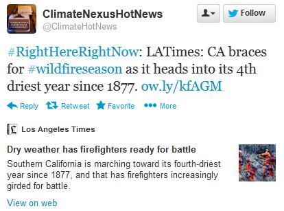
Dry Weather Has Firefighters Ready For Battle. The
fact that Californians are already complaining about dry weather - in
April - is not a good omen for the fire year to come. Details from the
Los Angeles Times: "
Southern
California is marching toward its fourth-driest year since 1877, and
that has firefighters increasingly girded for battle. In the hills of
Los Angeles County, tests show the brush is drying out at a
significantly quicker rate this year because of the lack of rain. In
Ventura County, firefighters say the parched conditions feel like what
they typically see in June or July. The California Department of
Forestry and Fire
Protection, which handles fire protection for about a third of the
state, said it has dealt with 150 more blazes so far this year compared
with 2012..."
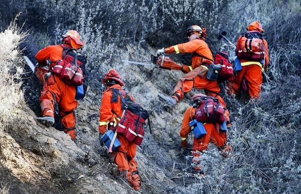
Photo credit above: "
A crew from the Department of
Corrections and Rehabilitation cuts foliage to help contain a
wind-driven brush fire that broke out near Fillmore last week, forcing
evacuations and threatening homes. Southern California is marching
toward its fourth-driest year since 1877, and that has firefighters
increasingly girded for battle."
(Al Seib, Los Angeles Times / April 9, 2013)
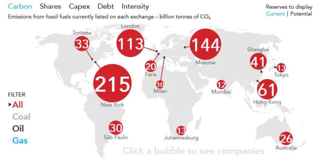
Carbon Bubble Will Plunge The World Into Another Financial Crisis - Report.
The Guardian has the story - here's the intro: "
The world could be heading for a major economic crisis as stock markets inflate an investment bubble in fossil fuels to the tune of trillions of dollars, according to leading economists. "The financial crisis
has shown what happens when risks accumulate unnoticed," said Lord
(Nicholas) Stern, a professor at the London School of Economics. He said
the risk was "very big indeed" and that almost all investors and
regulators were failing to address it. The so-called "carbon bubble" is the result of an over-valuation of oil, coal and gas
reserves held by fossil fuel companies. According to a report
published on Friday, at least two-thirds of these reserves will have to
remain underground if the world is to meet existing internationally agreed targets to avoid the threshold for "dangerous" climate change. If the agreements hold,
these reserves will be in effect unburnable and so worthless – leading
to massive market losses. But the stock markets are betting on
countries' inaction on climate change..."
* interactive Guardian map above is
here.
Fossil Fuels And Vested Interests: A Society In Denial. Here's a portion of an Op-Ed at
The Guardian: "
The report released by Lord Stern and thinktank Carbon Tracker
paints a picture of society in denial. It shows we're pumping almost
$700bn (£458bn) of hard-earned savings and pensions annually into
finding new reserves of fossil fuels,
even though it's clear that almost all of those reserves will have to
be written off to provide a decent chance of keeping the planet safe.
The ever-inflating "carbon bubble"
is only part of the bigger picture, because most of the world's fuel –
around three-quarters in total and almost all the oil and gas – is
owned not by listed companies but by governments. And we don't need
only to stop expanding the world's fossil fuel reserves; we also need
to get used to the idea that we can't burn most of what we already have..."


No comments:
Post a Comment