81 F. high in the Twin Cities Sunday.
September 29, 2012: last time it got this warm in the metro area (82F).
64 F. average high for April 28.
51 F. high on April 28, 2012.
1"+ rain possible latter half of this week.
Ice-out on most metro area lakes within the next 2 days.
A Mixed Blessing
Meteorologists often come off as Spock-like,
Doppler-loving automatons; finger-pointing nerds who relish a good
storm. Truth? We do.
But when weather is persistently foul (Exhibit A: this spring) it's no fun predicting the future.
Every day brings a chorus of new complaints.
"Can't you DO something about this lousy weather, Paul?" When's the last
time a sportscaster got BLAMED for the Twins losing? Totally irrational
- but I guess it comes with the turf.
Sure, we've had 3 plowable snowfalls in April,
nearly 18" snow - the snowiest month of the season; almost 4 times more
snow than fell in January!
Not. Right.
But a fire-hose of Gulf moisture has returned,
fueling a parade of very wet storms. The drought is fading fast and the
metro area should avoid the most serious river flooding in the weeks
ahead. So it's not all bad news, right?
Wait, I think I hear crickets.
Expect lukewarm sun today & Tuesday,
followed by 1-2" rains and greening lawns later this week, as a huge
storm stalls over the Plains. Wednesday's soggy cold front does a
U-turn; more rain pinwheeling in from the east by late week. Wet snow
could mix in by Friday.
Excuse me while go I yell at the weatherman.
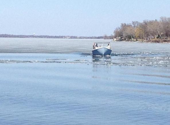
"Ice Breakers" Hasten Winter's Retreat On Lake Minnetonka.
This is new one - using boats and waverunners to accelerate
ice-out? Can you tell locals are getting frustrated with our extra-late
spring? Here's an excerpt from
Lake Minnetonka Patch: "
Boats—and
even jet skis—were out on Lake Minnetonka yesterday trying to break up
ice and hasten the arrival of open water season."
Photo credit: "
The photo received more than 40 "like" on Lake Minnetonka's Facebook page in less than 24 hours.
" Credit Jay Corn.
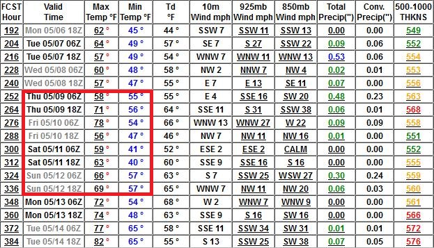
Promising Fishing Opener Outlook?
It's still pretty far out, but the cold, rainy (possibly snowy at
times) atmospheric holding pattern that will torment us from Wednesday
into Sunday should be gone by May 9. Highs on Fishing Opener Weekend may
reach the 60s and 70s for metro lakes; 10 degrees cooler up north, but
all things considered - not bad.
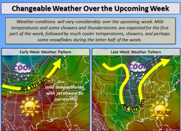
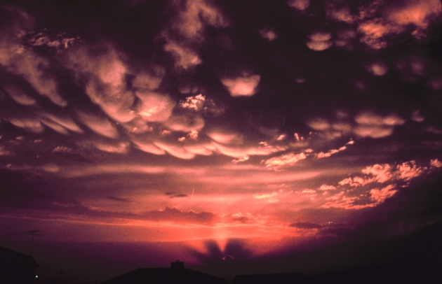
A Kink In The Jet.
A "cut off" low, a blob of Canadian air cut off from the main belt of
westerly winds aloft, will dredge up more Gulf Moisture; weather systems
in a soggy holding pattern the latter half of the week into next
weekend. Precipitation will fall as mostly rain, but a little wet snow
can't be ruled out. Weather story courtesy of the MPX NWS.
Big Changes. Mother Nature remains mellow today and
much of Tuesday, but a cold slap across the face is shaping up by
midweek, highs near 40F by Wednesday with a cold rain, possibly mixing
with a little wet snow. There's another surge of moisture shaping up for
late week, probably rain, but a little snow can't be ruled out Friday
night. Showers spill over into Sunday; 60s returning next week.
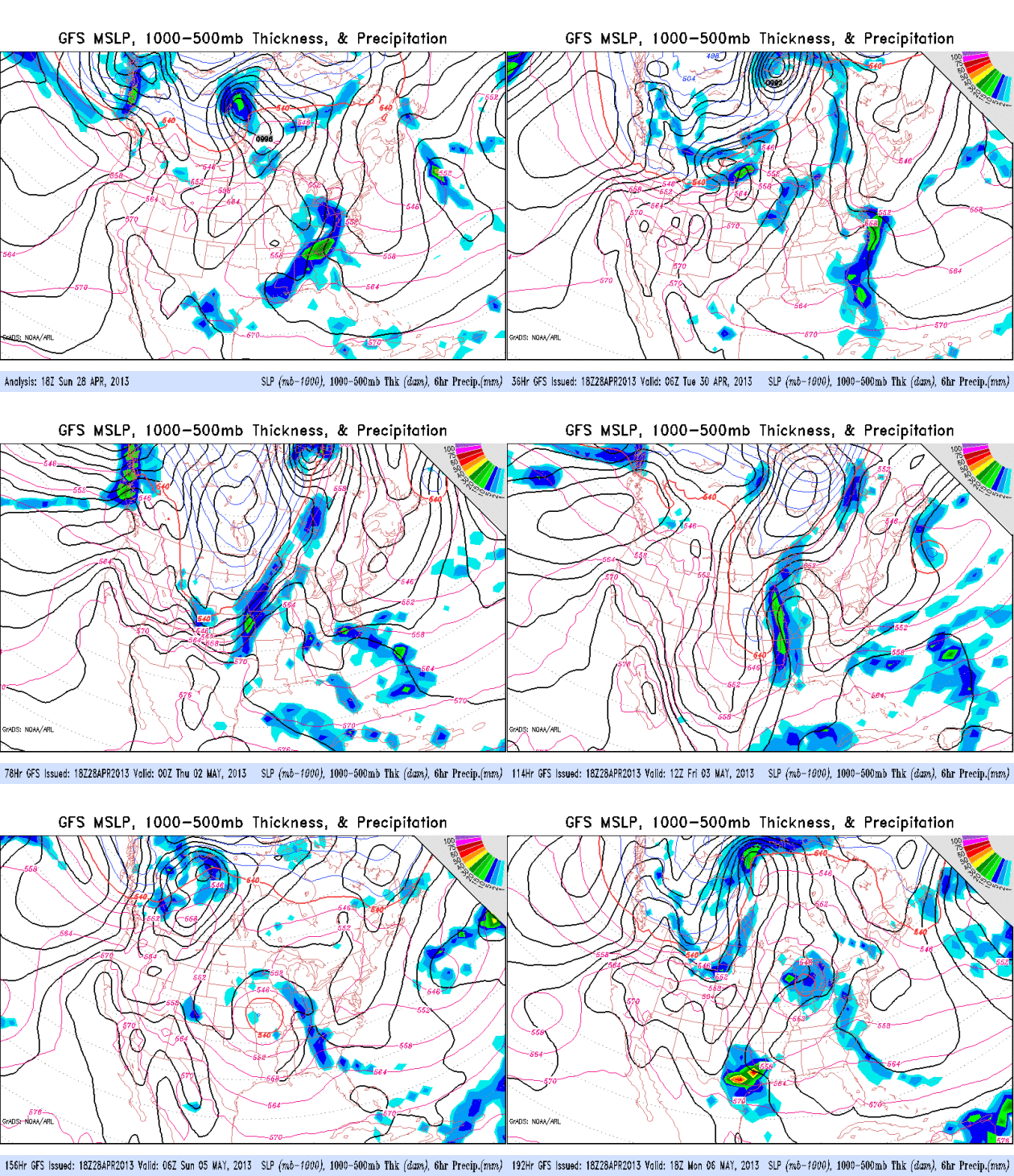
Unusual For May. These cut-off lows are more typical
in March or October, rare (but not unprecedented) for early May. The
same pattern that's pumping a steady stream of drought-busting moisture
northward is also pulling unusually chilly air south out of Canada. It's
hard to have one without the other. A storm aloft is forecast to stall
over Missouri, counterclockwise winds pumping more rain (and a little
wet snow?) back into Minnesota by late Thursday into Saturday. GFS
model: NOAA.
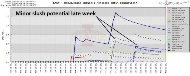
Nuisance Snow? Plowable? Probably not, but the fact
that we're even having this conversation heading into early May. GFS
model runs are hinting at minor amounts of slush the latter half of the
week. If anything does stick it won't be in your yard for long. Good
grief.
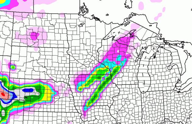
PG Rated Weather Map. PG for pretty grim. But right
now the latest NAM model keeps accumulating snow over southeastern
Minnesota, western Wisconsin and parts of Iowa. The axis of slush may
wave back and forth from east to west in the coming days - too early to
know who may wake up to a (very rare) May snowfall.
Maximum 24 Hour May Snowfalls in the Twin Cities:
3" May 1, 1935
2.8" May 11, 1946
* source: Minnesota Climate Office.
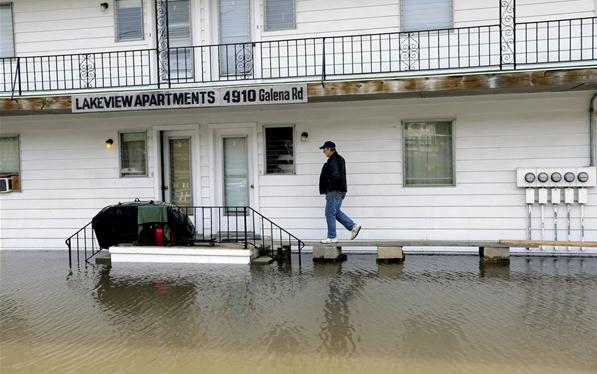
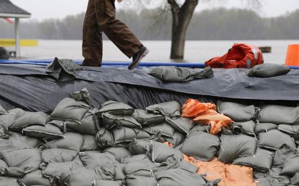
Midwest States Continue To Fight Record Flooding. Here's an excerpt of a story at
The Los Angeles Times: "
After
months of drought, many areas of the Midwest on Saturday continued to
fight off flooding from rising rivers that are not expected to crest
for several more days. National Weather Service forecasters expect flooding to continue throughout the week along the Des Plaines, Fox, Illinois and other rivers and their tributaries in Illinois. U.S. Geological Survey monitors in the area have recorded record floods. Illinois Gov. Pat Quinn
has declared 48 counties in his state disaster areas. In making the
announcement, he noted that water is receding in some areas but rising
in others. “We are continuing to do everything we can to provide the
personnel and resources needed to fight the flooding,” Quinn said..."
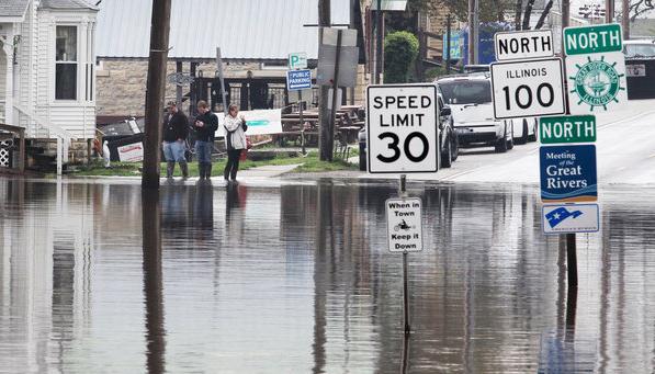
Photo credit: "Water covers the
intersection of Illinois State Route 100 and Route 3 in Grafton, Ill.,
on Tuesday. Swollen rivers in the Midwest are expected to remain at
high levels into next month." (Derik Holtmann / Associated Press / April 23, 2013)
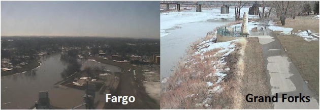
Tracking The Rising Red River. Click here to see a live webcam from Fargo, courtesy of the City of Fargo. USGS has a webcam in the Grand Forks area
available here.
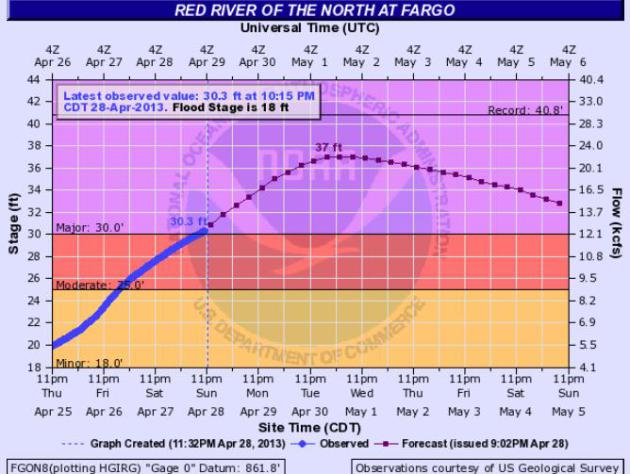
Some Good News For Fargo. Flood Warnings are posted
for the Red River now, a Flood Watch for northwestern Minnesota and
northeastern North Dakota for rapidly melting snow and ice dams causing
sudden rises in streams and rivers. The latest
NOAA forecast
for Fargo shows a crest near 37 feet between Tuesday night and
Wednesday night, a foot lower than predicted Saturday, and 3-4 feet
below the high water mark set in 2009.
Effects Of Midwest Flooding Will Be Felt For Months.
NBC News
has a good overview of the problems, including a wild swing from not
enough water in the Mississippi River a couple months ago to severe
flooding in recent days; here's an excerpt: "...
To the north, a
damaged lock may keep a stretch of the Illinois River closed to
commercial shipping traffic for weeks, the U.S. Army Corps of Engineers
said. Flooding has halted the transport of corn and soybean barges at
certain terminals on the river, Reuters reports. The disruptions could
cause significant disruptions in the flow of grain and corn in the
second-highest soybean producing state. Reuters reports almost 60
percent of U.S. grain exports are transported on the Mississippi River
and its tributaries. Grain prices at export terminals at the Gulf of
Mexico climbed this week to the highest level in at least a month due
to the disruptions..."
Photo credit: Seth Perlman / AP. "
Steve Peters uses a
make shift bridge to access dry land in Peoria Heights, Ill. The
Illinois River crested at 29.35 feet, eclipsing a 70-year record in
Peoria."
Up To 375 Flood Gauges To Turn Off Because Of Fund Cuts. Doyle Rice from
USA Today has a head-shaking story, another victim of "The Sequester". Coming at a good time huh? Here's an excerpt: "
Just
in time for the spring flood season, the federal sequester is
threatening to shut off funding for hundreds of stream gauges used by
the U.S. Geological Survey to predict and monitor flood levels across
the country. "The USGS will discontinue operation of up to 375 stream
gauges nationwide due to budget cuts as a result of sequestration," the
USGS notes on its website. Additional stream gauges may be affected if
USGS partners at state and local agencies reduce their funding
support..."
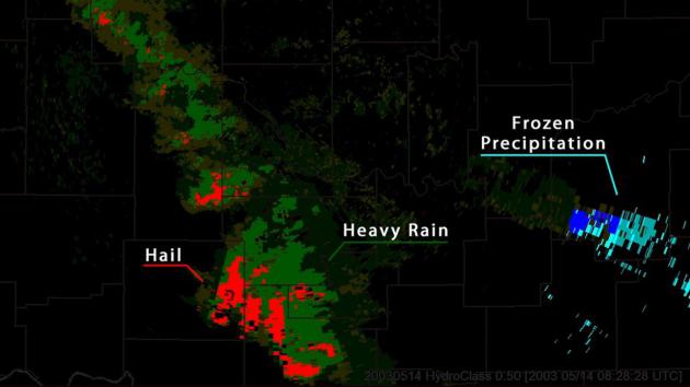
NOAA's National Weather Service Completes Doppler Radar Upgrades.
New "dual-pol" Doppler upgrades do a better job calculating
precipitation types and rainfall and snowfall amounts - so sensitive
they can even detect the debris signature from a tornado on the ground.
More details from
NOAA: "
This week, the National Weather Service
completed the dual-polarization technology update in Brownsville,
Texas – concluding the 122 NWS radar site upgrades throughout the
country. This new advanced technology is helping federal weather
forecasters more accurately track, assess and warn the public of
approaching high-impact weather. Dual-polarization
is the most significant enhancement made to the nation’s federal
weather radar system since Doppler technology was first installed in
the early 1990s. Dual-pol radar sends and receives both horizontal and
vertical pulses, which produces a much more informative picture of the
size and shape of the objects in the sky. This provides
meteorologists the ability to distinguish between rain, snow, hail and
non-weather items like wildfire smoke plumes, birds and insects.
Conventional Doppler radar only has a one-dimensional view making it
difficult to tell the type of precipitation or object in the sky..."
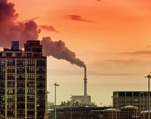
Is Air Pollution Contributing To Hardened Arteries? Some of the research was done in St. Paul, among other U.S. cities. Here's an excerpt from a story at
Time Magazine: "
Smog and car exhaust can take a toll on the heart, and the latest research explores how. Previous studies have shown an association between badly polluted air and a heightened risk of heart attack stroke,
and researchers have started to investigate how pollutants could exert
such harm. Some have documented the increased inflammation that
pollution can trigger, as well as changes in blood pressure and the
activity of clotting factors in the blood that could promote heart heart disease.
The latest research, published in the journal PLOS Medicine, found that
exposure to air pollution may increase heart attacks and strokes
by accelerating the process of atherosclerosis..."
Heat Spike. From 4" snow on a Tuesday morning to 81F
5 days later? Even by Minnesota standards that's impressive. Sunday
highs ranged from 56 at Grand Marais to 68 Duluth (6" snow left) to 77
St. Cloud, 81 Twin Cities and a balmy 83 at Redwood Falls.
On April 28 in Twin Cities Weather History (courtesy of the Twin Cities National Weather Service):
1984: Late season snow blankets the Twin Cities with 6.6 inches.
1940: Heavy rains in Duluth with 3.25 inches of rain.
TODAY: Partly sunny & pleasant. Winds: SE 5-10. High: 71
MONDAY NIGHT: Clouds increase - showers possible late, especially central/northern Minnesota. Low: 50
TUESDAY: Early shower or T-shower, then mild sun. High: 74
WEDNESDAY: Much colder, periods of rain. Wake-up: 43. High: 45
THURSDAY: Chilly. Light rain and drizzle. Wake-up: 37. High: 42
FRIDAY: Rain may mix with a little wet snow. Wake-up: 35. High: 43
SATURDAY: Gloomy & raw. More light rain. Wake-up: 34. High: 45
SUNDAY: Still damp. Lingering showers. Wake-up: 38. High: 46
Climate Stories...
Climate Change: Extreme Weather, Insurance Companies And Taxpayers. Here's a video and excerpt from
The Energy Collective: "
This NRDC
video discusses the costs of extreme weather events, which in 2012
totaled one percent of the nation’s gross domestic product. Insurance
companies are “under water”
in more ways than one and the US taxpayer ended up paying what is
essentially a “climate disruption” of 2.7 percent more than the total
collected in sales taxes for 2012..."
Climate Change: It's Real And It's Here, Expert Says. Here's a clip from
htrnews.com: "
Twenty-five
years ago, James Brey was a climate change denier. “Then the evidence
began to mount,” he said. “At some point, doubts began to diminish and
the conviction began to grow.” Today, Brey, American Meteorological
Society education program director, is a believer. You might say he was
preaching to the choir Thursday night when he spoke to a group of
about 50 concerned citizens gathered in the Riverview Room at the
Wisconsin Maritime Museum for his climate change workshop. The workshop
was presented by Friends of the Manitowoc River Watershed in
conjunction with the Lakeshore Natural Resources Partnership..."
China Becoming Global Climate Change Leader. There
is little "debate" about the science of climate change in China, which
is a bit ironic. They realize they have a problem, and they're taking
concrete steps to address those problems, according to this article from
AFP and
Google News: "
China
is rapidly assuming a global leadership role on climate change
alongside the United States, a new study said Monday, but it warned
greenhouse gas emissions worldwide continue to rise strongly. The
report by the independent Australian-based Climate Commission, "The
Critical Decade: International Action on Climate Change" presents an
overview of action in the last nine months. It was released on the same
day as a fresh round of UN talks were to start in Bonn on boosting
action on climate change -- a two-decade-long process that has been
dogged by procedural bickering and defence of national interests. The
study found that every major economy had policies in place to tackle
the issue, but China was at the forefront in strengthening its response,
"taking ambitious strides to add renewable energy to its mix". "China
is accelerating action," said Tim Flannery, the co-author and a key
figure at the Climate Commission, which brings together
internationally-renowned scientists, as well as policy and business
leaders..."
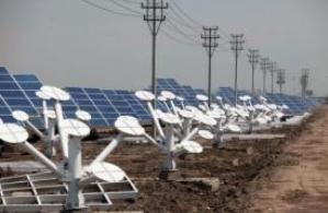
Photo credit: "
Solar panels in the Sino-Singapore Eco-city near Tianjin on June 11, 2012." (AFP/File, Ed Jones)
The Oddly Tepid Political Fight Over Global Warming. Here's an excerpt from a story at The Atlantic Wire: "
Yesterday
afternoon, a panel of experts was convened by a House subcommittee to
discuss taking action on climate change. Earlier, the heavy machinery
that was once Barack Obama's campaign team, Organizing For America,
began a new push to hold politicians to task for having not yet done
anything on the issue. The odds are good that you didn't know that
either of these things happened. The urgency with which scientists and
the environmental community looks at global warming has still not been
translated to Capitol Hill — or to the rest of America. The House
hearing, led by Republican Rep. Chris Stewart of Utah, was never likely
to create a massive shift in the politics of the climate. Stewart has
long denied a strong human role in warming, writing an opinion piece for the Salt Lake Tribune earlier this month in which he claims that "the science regarding climate change is anything but settled." (Scientists disagree.) Stewart's essay did have one positive outcome: the Tribune was also the only media outlet to cover yesterday's hearing..."
Image above: AP.
On Climate, GOP Turns From Concern To Denial. Here's a clip from an Op-Ed at
The Houston Chronicle: "...
How
did the conservative movement travel so far, so fast? How did a party
that prided itself on reason become a hotbed of scientific denial? The
transformation has paralyzed U.S. policymaking and squandered decades
that could have been spent weaning the world from fossil fuels.
Twenty-three years after Thatcher urged action, the United States has no
policy on climate change, even as its effects are evident and the
window for action is closing. In 1997, "There was no difference between
the way Democrats and Republicans across America viewed the issue," said Ed Maibach, executive director of George Mason University's Center for Climate Change Communication,
a research center. Two out of three Democrats and two out of three
Republicans believed that climate change was both real and serious.
"Somewhere along the way, conservatism became, 'I've got a God-given
right to drive my SUV wherever I want to go, and we'll send somebody
else's kids to the Middle East to fight for it," said former South
Carolina Rep. Bob Inglis, a Republican who lost his 2010 primary election over global warming and now runs the Energy and Enterprise Initiative, where he is pushing for a price on carbon pollution..."
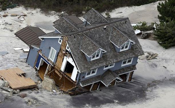
The Drought-Stricken Midwest's Floods: Is This What Climate Change Looks Like? Here'san excerpt from a story at
The Atlantic Wire: "...
In other words, a warmer atmosphere from climate change likely yields greater extremes in weather. This syncs with the draft report issued
by the government's National Climate Assessment Development Advisory
Committee last year. That report predicted the following for the
Midwest: "longer growing seasons and rising carbon dioxide levels will
increase yields of some crops, though those benefits will be
increasingly offset by the occurrence of extreme events such as heat
waves, droughts, and floods." That prediction was meant to be borne out
over the next several decades. What it predicted, though, has already
been seen over the course of six months..." (photo: AP).
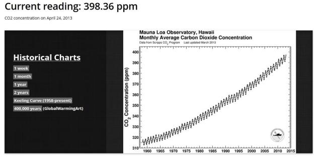
As CO2 Concentrations Near Ominous Benchmark, Daily Updates Begin.
Scientific American has the story - here's an excerpt: "...
Scientist
Ralph Keeling wants this generation to remember when atmospheric
concentrations of carbon dioxide reached 400 parts per million, because
of humans. "I hope that many people out there in the decades to come
will say, 'Gosh, I will remember when it crossed 400,'" he said. That's
why Keeling and his employer, the Scripps Institution of Oceanography at the University of California, San Diego, have launched a website that will provide daily updates on atmospheric CO2 concentrations, measured at Hawaii's Mauna Loa Observatory..."
Graphic credit above: 398.36 ppm. The very latest CO2 concentrations can be found at
The Keeling Curve web site, operated by Scripps Institution of Oceanography.
CO2 On Trial: If Things Had Worked Out Better.
Here's an excerpt of an important article, an explanation of how climate
science has been turned into a perverse mock "trial". Michael Tobis
argues that we need to grow up, and recognize our limits in this story
at
medium.com: "...
The
fact is that we are entering an age of new and unprecedented limits.
We can still have a happy future, human achievement and human dignity
can continue its broad historical progress, and we can still have a lot
of fun. But we have to recognize new limitations. The emergence of
limits is unfortunate. It's costly. It's ill-timed. But preserving a
stable environment is an ethical responsibility like none that has
preceded it. We need people to understand not only that CO2 is a global
problem, but that it's just the first in a series, as we make the
transition from an open frontier world to spaceship earth. As a brand
of soap, this is a hard sell. We have to sell the idea of a widespread
set of changes in behavior, a new set of ethical constraints, and a
substantial increase in the complexity and scale of governance. There
are serious risks and costs involved, but avoiding this responsibility
will yield something much worse..."
Global Warming Accelerated Last 15 Years. Here's an excerpt from Doug Craig's terrific
Climate of Change blog at Redding.com: "...
And
a new study of ocean warming published last month in Geophysical
Research Letters by Balmaseda, Trenberth, and Källén reached several
conclusions:
• Completely contrary to the popular contrarian myth, global
warming has accelerated, with more overall global warming in the past
15 years than the prior 15 years. This is because about 90% of overall
global warming goes into heating the oceans, and the oceans have been
warming dramatically.
• As suspected, much of the 'missing heat' Kevin Trenberth
previously talked about has been found in the deep oceans. Consistent
with the results of Nuccitelli et al. (2012), this study finds that 30%
of the ocean warming over the past decade has occurred in the deeper
oceans below 700 meters, which they note is unprecedented over at least
the past half century..."






No comments:
Post a Comment