54 F. high in the Twin Cities Tuesday. That's the average high on April 8 in Minneapolis/St. Paul
71 F. average high for May 22.
85 F. high on May 22, 2012.
4.53" rain so far in May; that's 2.14" wetter than average, to date.
11.79" precipitation since March 1, or 4.85" wetter than normal.
Tornado Aware
Our hearts go out to residents of Moore, Oklahoma, recovering from the 3rd violent tornado in 14 years. Talk about bad luck.
Minnesota has experienced 2 EF5 tornadoes since
1950. No, we don't live in traditional Tornado Alley but we do live in
Tornado Cul de sac. EF4 tornadoes ravaged parts of the metro in 1965.
Since then the MSP metro has expanded. Urban sprawl is relentless.
Future tornadoes that would have hit farmland 20 years ago may plow into
neighborhoods, undeterred by buildings, asphalt and concrete.
What keeps me up at night? The specter of
another EF4 dropping in the close-in suburbs. Doppler radar helps with
detection, but technology isn't foolproof; there's still no way to
predict, in advance, how severe a tornado will become.
Practice a tornado drill with your family; invest in a NOAA Weather Radio and smartphone apps. Have a plan, just in case.
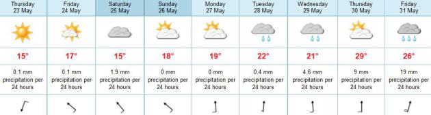
Spring stages a minor comeback today with
badly-needed sunshine. Showers return Friday night, a few T-showers
Sunday as warmer air pushes north. Memorial Day looks like the best day:
70s with some sun. 80s return next week; a shot at 90F by Thursday.
Next week may be ripe for a few severe thunderstorms.
Yes, we're due.
ECMWF: Holiday Weekend Not A Total Loss. After the
spring we've endured are you really surprised that the first holiday
weekend of the summer season may be cooler than average, with a chance
of showers? Me neither. The European model shows showers tapering early
Saturday; most of the rain and embedded T-storms staying south/west of
MSP Sunday and Memorial Day as temperatures slowly warm. We'll see 80s
next week, even an outside shot at 90 by Wednesday or Thursday.
American Models: A Plan B Memorial Day Weekend?
There is significant difference in model solutions - U.S. models
printing out considerable more rain this upcomign weekend, maybe some .7
to 1" amounts Friday night, more scattered showers and T-showers Sunday
and Monday as warmer air tries to push north into Minnesota. Although
I'm leaning toward the (drier) ECMWF solution, try and keep your weekend
expectations low. Maybe we'll all be pleasantly surprised.
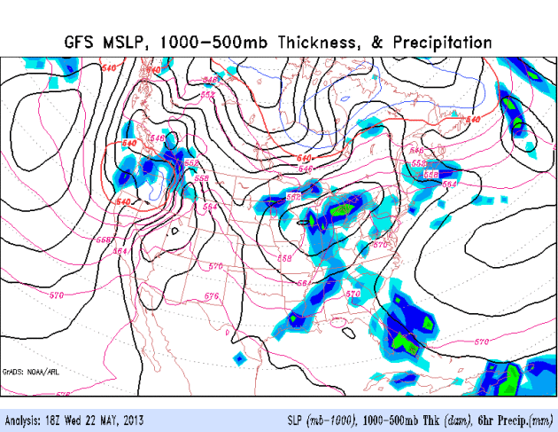
An Ill-Timed Warm Front. Warm air can't just push
cool air out of the way - cool air needs to retreat on it's own. The GFS
model above suggests a bit of a pushing and shoving match taking place
in the skies above Minnesota and the Upper Midwest this weekend;
scattered showers and T-storms - Memorial Day probably the mildest day
of the 3 day weekend.
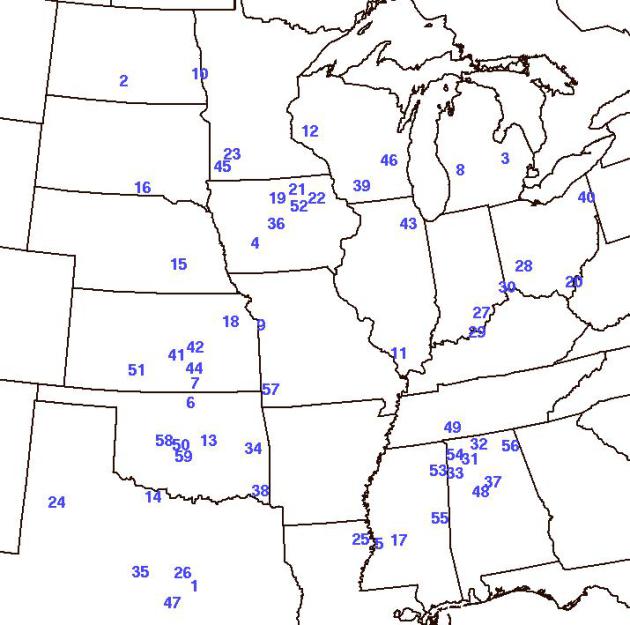
How Rare Are EF5 Tornadoes? Since 1950 there have
been only 59, two in southwest Minnesota. The Moore, OK tornado was
considered an EF5 with winds up to 210 mph. There were 6 in 2011;
including the Joplin, MO tornado that occurred 2 years ago - May 22,
2011. According to Wikipedia the Joplin, MO tornado was the 7th
deadliest (162 people died) and the costliest ($2.8 billion) single
tornado in U.S. history. Map above showing the location and year EF5
tornadoes struck courtesy of
NOAA SPC.
Moore In Bulls-Eye Twice; Science May Know Why. Here's an excerpt from a story at
CNN.com:
"...Dallas-Fort Worth, Kansas City and St. Louis are also considered
high risk for severe tornadoes, according to Harold Brooks of the
National Oceanic and Atmospheric Administration's Severe Storms
Laboratory in Norman, Oklahoma. Yet, none of those metro areas has been
through what Moore has experienced. Monday's storm caused enormous
property destruction and killed at least two dozen people. Yet it was a
relatively ordinary violent tornado," according to Brooks, an
acknowledged expert on the climatology and probability of twisters..."
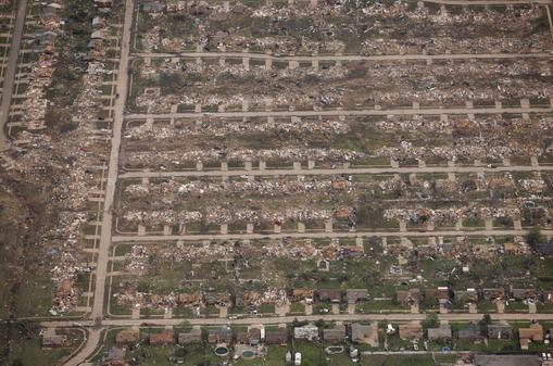
Photo credit above: "
An aerial view of the extensive
damage caused by Monday's tornado, near Oklahoma City and Moore, Okla.,
May 21, 2013. Oklahoma officials said they hoped to finish their search
for survivors of a massive tornado by nightfall, a little more than 24
hours after the Oklahoma City area was slammed by a storm that killed
dozens of people." (Matthew Staver/The New York Times).
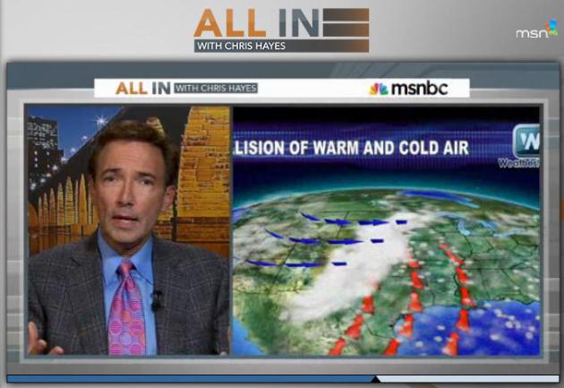
What Happens When A Tornado Hits? Here's an excerpt of an interview I gave to Chris Hayes on
MSNBC Monday evening, describing the dynamics of an EF4/EF5 tornado.
A Tornado Isn't An Object, But Rather A Process.
Tuesday night I had a chance ot explain how tornadoes form, the physics
able to translate spin around a horizontal axis into a vertical axis
(with the help of some great special effects). Here's the video clip
from "All In With Chris Hayes" on
MSNBC. My segment is about 8:00 in.
When Tornadoes Are A Way Of Life. Here's an excerpt of a radio interview I gave to Jennifer Ludden at
NPR's Talk of the Nation on Tuesday: "...
I
think one of the issues that we have in this country is a certain
degree of tornado fatigue. Seventy percent of all tornado warnings,
Jennifer, are false alarms, you know? Nobody wants to get caught with
their Doppler down. So any time we see rotation in a thunderstorm, the
temptation is to issue the warning. But in the process, we're all kind
of bombarded with warnings. You start to tune out. And on a day like
yesterday, you need to break through the clutter and the apathy and the
cry-wolf syndrome and shape people viscerally and emotionally. And the
words that you chose - I think any sociologist will tell you the words
you choose are critical in conveying that level of risk. At one point,
Mike Morgan actually said: If you don't have an underground shelter,
this tornado is unsurvivable. Get into your vehicle, try to drive away -
which you never, ever hear. And yet, that was the magnitude of the
tornado threat yesterday. The problem is with tornados, we don't know
right away if it's an EF1 or an EF4..."
Tornadoes And Urban Sprawl: How Long Until A Major City Is Hit?
Oklahomans know exactly what to do when a major tornado is approaching,
living at Ground Zero of Tornado Alley. But what happens when a similar
(extreme) tornado hits a major city or densely populated suburb? We're
not even close to being ready for that scale of weather disaster. Here's
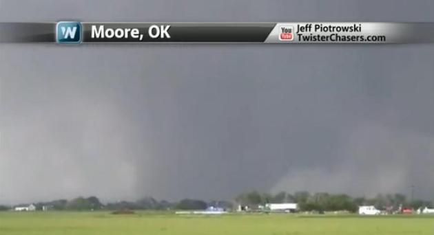
a link to a video from
WeatherNation TV: "
Meteorologists
Paul Douglas and Susie Martin look at the severe threat for the coming
days, as well as the statistics and the role urban sprawl has when it
comes to the risk of a strong tornado hitting a major city."
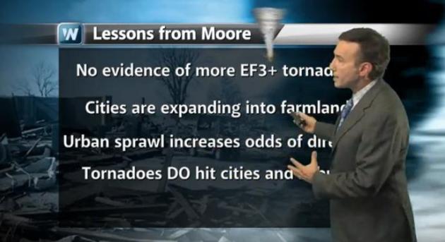
Lessons From Moore Tornado Disaster. In today's edition of
Climate Matters
I take a look at some of the implications of the Moore EF-5 tornado,
including situational awareness, multiple information safety nets, and
why you need to REALLY pay attention the next time a "Tornado Emergency"
is issued for your area.
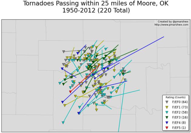
A Staggering Statistic. Meteorologist
Patrick Marsh calculates that 220 tornadoes passed within 25 miles of Moore, Oklahoma from 1950 to 2012. Good grief.
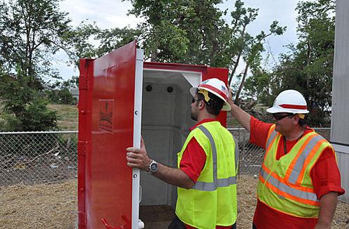
The Rise Of DIY Tornado Shelters. Do you really need
to spend thousands of dollars to retrofit a closet into a steel and
concrete-reinforced "safe room", able to withstand even an extreme
tornado? There may be some things you can on your own. Here's an excerpt
of a timely story from
AccuWeather.com: "...
Homes
without storm cellars or basements offer little protection from a
tornado. While windowless rooms and closets offer more safety than other
parts of the house, people are still left vulnerable to tragedy when
storms strong enough to level entire structures come through. Storm
shelters are built to withstand winds that standard household rooms are
not equipped to handle. There have been cases of safe rooms remaining
completely intact, protecting the people inside, as the entire building
around it crumbles to the ground in a tornado. As people try to prepare
for the worst, companies that produce do-it-yourself storm and tornado
shelters are reporting a sharp increase in sales..."
Photo credit above: "
Robert Hanna, civil engineer,
and Jeff Ice, quality assurance inspector, both from the U.S. Army
Corps of Engineers, check out a tornado shelter." Photo courtesy of
US Army Corps of Engineers
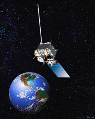
NOAA Satellite Malfunctions; May Affect Forecasts. This is not a good development. Meteorologist Andrew Freedman at
Climate Central has the story; here's an excerpt: "
As
the weather system that spawned the deadly Moore tornado moves
eastward, the main weather satellite used for observing and forecasting
conditions across eastern North America and the Atlantic Ocean has gone
offline. It's the second malfunction since September 2012, when a
technical glitch was fixed by engineers working from the ground.
According to the National Oceanic and Atmospheric Administration
(NOAA), which operates the nation’s fleet of weather satellites, the
satellite, known as GOES-13, initially malfunctioned at 11:40 p.m.
eastern time on Tuesday. An initial recovery procedure was unsuccessful
at restoring it to operation..."
Graphic credit above: "
NOAA rending of a GOES satellite." Credit: NOAA.
Beer Warning. If this web site doesn't make you thirsty, I don't know what will. It's a local (Minnetonka) company with a
marketing hook
that is sure to get people interested, especially meteorologists. Come
to think of it my doctor tells me I'm not drinking enough good beer.
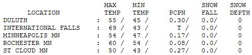
Spring: Missing In Action. No, it didn't feel like
late May yesterday - I'm just happy it didn't snow. Where the sun was
out temperatures shot up close to 70 at International Falls and 68
Hibbing. With thick clouds spitting light rain temperatures were 15
degrees cooler than average, highs ranging from a brisk 50 at St. Cloud
to 54 in the Twin Cities and 60 at Rochester.
TODAY: Partly sunny, cool breeze. Winds: NE 10-15. High: 67
THURSDAY NIGHT: Clear to partly cloudy, still cool. Low: 44
FRIDAY: Sunny start, clouds increase PM hours. High: 68
FRIDAY NIGHT: Chance of showers, possible thunder. Low: 50
SATURDAY: Early shower, skies brighten PM hours. High: 64
SUNDAY: More clouds, few showers and T-storms possible (especially south/west of MSP). Wake-up: 52. High: 68
MEMORIAL DAY: Some sun, mildest day. Wake-up: 55. High: 73
TUESDAY: Mostly cloudy, turning warmer. Wake-up: 59. High: 81
WEDNESDAY: Feels like summer - finally. Warm & sticky again; few T-storms. Wake-up: 61. High: 84
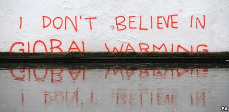
Climate Stories...
Making Sense Of The Moore Tornado In A Climate Context. Climate Central meteorologist Andrew Freedman does a good job connecting the dots; here's an excerpt: "...
Tornado data
does not reveal any clear trends in tornado occurrence or deaths that
would suggest a clear tie to global warming, at least not yet. A recent paper
published in the Bulletin of the American Meteorological Society found
that the occurrence of EF-1 and stronger tornadoes on the Enhanced
Fujita Scale has shown no trend since 1954, which was the first year of
near real-time data collection. Instead, an increase in tornado counts
of EF-0 or stronger tornadoes has been attributed to an uptick in
observations of very weak tornadoes. The Enhanced Fujita Scale measures
tornado strength based on the extent and type of damage that they cause
(no surface weather station has ever survived a direct tornado strike
to take wind measurements from inside a twister)..."
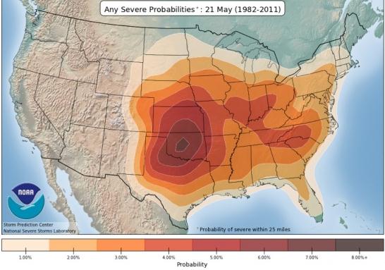
Graphic credit above: "
Probability
of severe thunderstorms within 25 miles of a location as averaged from
1982-2011. This shows the highest odds of severe weather on Monday
were in Oklahoma." Credit: Storm Prediction Center.
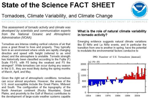
Tornadoes, Climate Variability and Climate Change.
NOAA has a fact sheet on what we know, and what we don't know, regarding
tornado frequency and intensity in a warming atmosphere.
Here's a link to the PDF.
Seeking Clarity On Terrible Tornadoes In A Changing Climate. Here's an excerpt of an Andy Revkin article at
The New York Times: "
The
vulnerability is almost entirely the result of fast-paced, cost-cutting
development patterns in tornado hot zones, and even if there were a
greenhouse-tornado connection, actions that constrain greenhouse-gas
emissions, while wise in the long run would not have a substantial
influence on climate patterns because of intertia in the climate system.
Some climate scientists see compelling arguments for accumulating heat
and added water vapor fueling the kinds of turbulent storms that spawn
tornadoes. But a half century of observations in the United States show
no change in tornado frequency and a declining frequency of strong
tornadoes..."
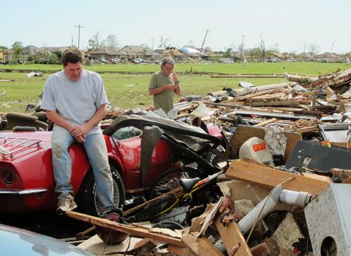
Photo credit above: "
Billy McElrath, left, sits on a 1968
convertible Corvette buried under rubble in what was the garage of his
home in Oklahoma City on Tuesday, May 21, 2012. The residents of Moore,
Okla., affected by a deadly tornado, are coming back to find their
belongings scattered and their homes left in pieces." (AP Photo/Sean Murphy)
Why Rational People Buy Into Conspiracy Theories. I thought this was interesting - here's a clip from a
New York Times story: "...
While
psychologists can’t know exactly what goes on inside our heads, they
have, through surveys and laboratory studies, come up with a set of
traits that correlate well with conspiracy belief. In 2010, Swami and a
co-author summarized this research in The Psychologist, a scientific
journal. They found, perhaps surprisingly, that believers are more
likely to be cynical about the world in general and politics in
particular. Conspiracy theories also seem to be more compelling to
those with low self-worth, especially with regard to their sense of
agency in the world at large. Conspiracy theories appear to be a way of
reacting to uncertainty and powerlessness..."


No comments:
Post a Comment