83 F. high in the Twin Cities Wednesday.
84 F. average high on July 10.
88 F. high on July 10, 2012.
Today: most comfortable day in sight, dew points in the upper 50s.
T-storms possible late Friday night, again Sunday.
Smoke from Canadian forest fires drifting into Minnesota, giving the sky a hazy/smoky look.
Higher Ground
Do you live in a flood plain? You may be (unpleasantly) surprised the next time you catch up with your insurance agent.
Many residents of Toronto didn't think they
lived in a flood zone, either. Monday evening two month's worth of rain
soaked the city; a record flash flood.
We've had floods since the dawn of time, but we
haven't seen 400 parts per million in CO2 levels for at least 800,000
years. It's basic physics: a warmer atmosphere holds more water vapor,
loading the dice in favor of more extreme rain events.
At a recent talk in Breezy Point locals marveled
at the 7 inches of rain that fell in one night in late June. The State
Climate Office counts FOUR 1-in-1,000 year floods since 2004, just in
Minnesota. No, it's not your imagination. The rain is falling harder.
We salvage another amazing day with blue sky
& low humidity. T-storms rumble in this weekend, and a string of 90s
may return by the end of next week. 100F highs aren't out of the
question in about 7-8 days.
It looks like Chantal may fizzle, drenching
Florida with tropical rains by Saturday. Meanwhile Super Typhoon Soulik
is headed toward Taiwan with 140 mph winds. Puts the mosquitoes into
perspective, huh?
Forecast: Canadian Smoke.
There's still a lot of haze out there - I suspect the milky cast to an
otherwise blue sky is the result of smoke from a major fire over Quebec
being swept south into Minnesota. More details about this major blaze
north of the border from
NASA:
"
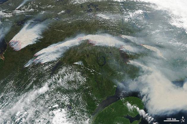
On July 4, 2013, the Moderate Resolution Imaging Spectroradiometer (MODIS) on NASA’s Aqua satellite captured this image of wildfires burning in western Quebec near James Bay.
Red outlines indicate hot spots where MODIS detected unusually warm
surface temperatures associated with fire. The image is centered at 65°
West longitude and 55° North latitude. MODIS also observed smoke from the fires moving across the Atlantic Ocean on July 5,July 6, and July 7. By July 8, smoke was drifting over Scandinavia."
CBC News in Montreal has more on the fires
here.
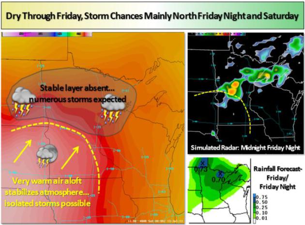
Weekend Set-up.
The Twin Cities National Weather Service has a good explanation of the dynamics behind weekend T-storms, which should be most numerous north of the Twin Cities: "
Seasonably warm and dry weather is on tap today. However, humidity
levels will rise on Friday, and showers and thunderstorms will
periodically impact the area from Friday night through the weekend. The
best chances will be north of I-94."
Stormy Possibilities.
As Chantal weakens into a westward moving wave of low pressure pushing
into the eastern Gulf of Mexico, a prod of hot, moist air will ignite
more T-storms from the Dakotas into Minnesota and Wisconsin by Saturday,
while the west stays sizzling, but generally dry.
Heating Up Next Week?
Models have been hinting at this for a few days, but the latest ECMWF
run for MSP shows a few days in the 90s next week; I wouldn't be
surprised to see highs close to 100F over southern and southwestern
Minnesota by the end of next week.
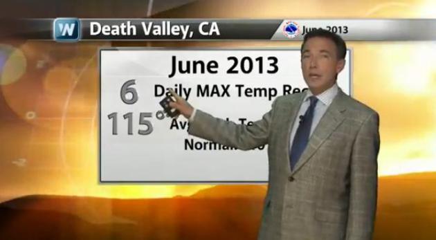
Anniversary Of The Hottest Observed Temperature on Earth. Today's edition of
Climate Matters focuses on heat, wildfires outside of Las Vegas, and why A/C in Tucson isn't optional these days: "
100
years ago today, Death Valley, CA hit 134 degrees, the hottest
temperature ever recorded anywhere on the globe. As we mark this
anniversary, we also look at some of this year's heat records and
stretches in the Southwest."
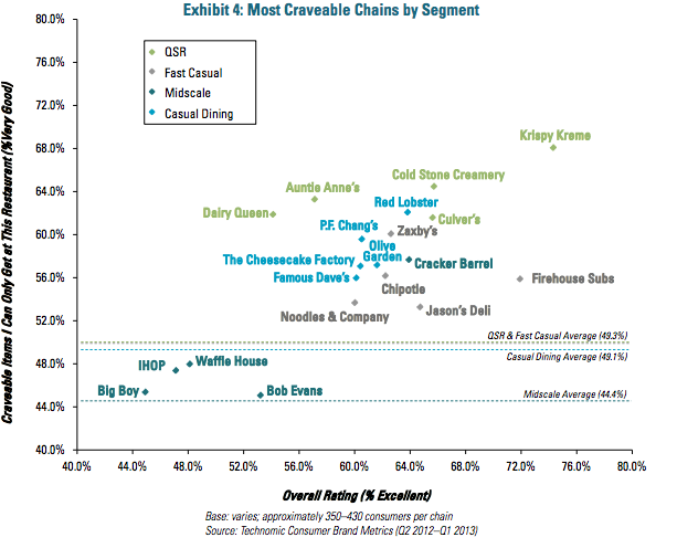
The Restaurant Chains With The Most Addictive Food. I
thought this was vaguely interesting - sorry to be including food in a
weather blog, but I'm hungry right now and it seemed like a good idea at
the time. Here's a clip from a story at
Huffington Post: "
Eighty-three
percent of consumers say that cravings are the main reason they
purchase food outside their home, according to a new report by market
research firm Technomic. Nearly everyone is subject to some kind of
comfort food craving at some point, and some restaurants know how to
give customers exactly what they want. Want some cheesy biscuits? Go to
Red Lobster. How about a massive portion of pasta? Hit up The
Cheesecake Factory..."
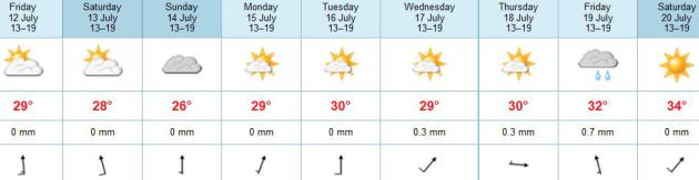
TODAY: Sunny, pleasant. Dew point: 58. Winds: South 10. High: 83
THURSDAY NIGHT: Clear and mild. Low: 65
FRIDAY: Fading sun, late T-storm? Winds: S 20+ High: 86
SATURDAY: Sticky, few T-storms. Winds: S 10-15. Wake-up: 70. HIgh: 88
SUNDAY: More numerous storms, humid. Wake-up: 72. High: 85
MONDAY: Front stalls, more T-storms nearby. Wake-up: 71. High: 87
TUESDAY: Partly sunny, steamy. Dew point: 71. Wake-up: 72. High: 91
WEDNESDAY: Blue sky, slight dip in humidity. Wake-up: 70. High: 88
Climate Stories....
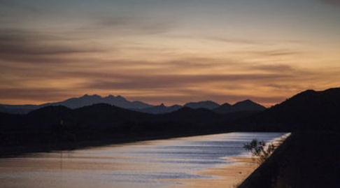
Water Worries: Climate Change in the Desert Southwest. Here's an excerpt of a story from
azcentral.com and USA Today: "...
Today,
the 56 million Americans in the fast-growing desert Southwest —
including those in the megacities of Phoenix, Los Angeles, Las Vegas and
San Diego — are faced with a challenge beyond the region's natural
dryness: coping with an uncertain future of man-made climate change and
how it will impact their life-sustaining supply of water. And while
worries about water lead the list of climate change concerns in the
Southwest, other issues, such as extreme heat waves and furious
wildfires, are also high on the list. Climate change is a special
concern in the Southwest, as the region continues to lead the nation in
population growth, according to the U.S. Environmental Protection
Agency. USA TODAY traveled to Arizona as another stop in a year-long
series to explore places where climate change is already affecting
America..."
Image credit: CAP Canal courterty of Arizona Republic.
Extreme Heat Reveals Extreme Infrastructure Challenges.
We need to upgrade and harden our infrastructure, make it more
resilient to extremes in weather and climate, as this article at
Grist points out - here's a clip: "
Having
trouble beating the heat this summer? Imagine how your infrastructure
feels. Last summer, we told you about extreme heat leading to buckling roads, melting runways, and kinky railroad tracks. Now we’re also hearing about droopy power lines and grounded airplanes. NPR’s Science Friday hosted a discussion
last week with Vicki Arroyo, executive director of the Georgetown
Climate Center, about how cities can adapt to hotter temperatures and
other climate impacts like floods and rising sea levels..."
Photo credit above: WMATA. "
Last summer, high temperatures caused a “heat kink” in the D.C. metro tracks."
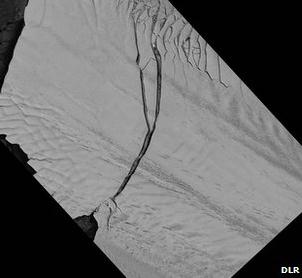
Antarctic's Pine Island Glacier Produces Giant Iceberg. The thinking is that warmer ocean water may be responsible for some of this calving of ice in Antarctic; the
BBC reports: "
Pine
Island Glacier (PIG), the longest and fastest flowing glacier in the
Antarctic, has spawned a huge iceberg. The block measures about 720 sq
km in area - roughly eight times the size of Manhattan Island in New
York. Scientists have been waiting for the PIG to calve since October
2011 when they first noticed a spectacular crack spreading across its
surface. Confirmation that the fissure had extended the full width of
the glacier was obtained on Monday. It was seen by the German TerraSAR-X
satellite. This carries a radar instrument that can detect the surface
of the ice stream even though the Antarctic is currently in the grip of
winter darkness..."
How Obama Plans To Make Global Warming Personal. ABC News has the story - here's the intro: "
Which
concerns you more: that polar ice caps are melting or that your kid
suffers from asthma? President Obama is well aware your answer is the
latter. The truth is, you should care about both. That's because
they're related. Climate change has contributed to everything from
rising rates of asthma among children to a seemingly endless allergy
season. The administration wants to point that out. So the White House
bestowed what they've dubbed the "Champions of Change" award on 11
people they say are "protecting public health in a changing climate" on
Tuesday morning..."
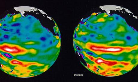
Charles Krauthammer's Flat-Earther Global Warming Folly. Here's a clip from a recent
Guardian article that focuses on denier data cherry-picking: "...
Of
course, the choice of the 16-year window is a juicy cherry pick. It
puts the starting point right at the formation of the 1997–1998 El
Niño, one of the strongest in the past century. During El Niño events,
heat is transferred from the oceans to the air, causing abnormally hot
surface temperatures. Focusing on the slow surface air warming over
the past 16 years is like arguing that your car is broken because it
slowed down as you approached a stop sign. Krauthammer is focusing on
an unrepresentative period during which the overall warming of the
planet continued, but less heat was used in warming the air, and more in warming the ocean. However, climate research suggests that this is just a temporary change,
and surface air warming will soon accelerate again. Krauthammer also
complains that "flat-earthers like Obama" have blamed heat waves on
human-caused global warming. Indeed, recent research has shown that Australian heat waves and record-breaking monthly temperature records in general are now five times more likely to occur due to global warming, with much more to come. Papers have concluded
that several individual heat records, like those in Texas and Oklahoma
in 2011 and Moscow in 2010, would not have been broken if not for
human-caused global warming..."
Image credit above: "
Images from the Jet Propulsion
Laboratory in California from 1997 show the build-up of the powerful El
Niño Krauthammer cherry picks." Photograph: AP.
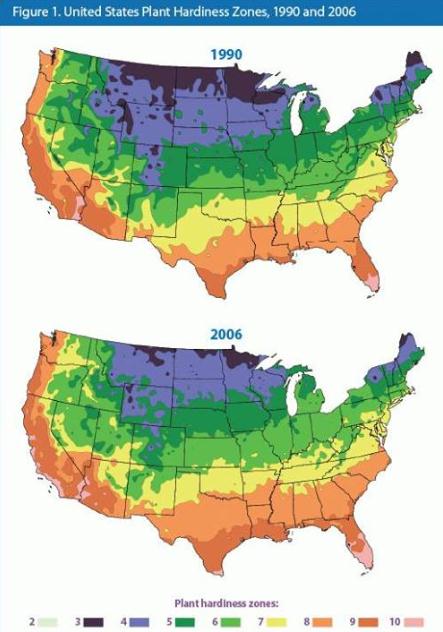
Shift In Plant Hardiness Zone: 1990 to 2006. In the
span of just 16 years you can see a pronounced northward shift in zones,
much of the Twin Cities now in Climate Zone 5. Thanks to meteorologist
Danny Satterfield and
Facebook for this image.


No comments:
Post a Comment