By Paul Douglas
Why was Tuesday's hailstorm so damaging in Eden Prairie & Edina? The combination of hail AND wind: hail swept along by 60 mph winds; a barrage of icy artillery shells. 2 inch diameter hail strikes the ground at 60-70 mph; throw in straight-line winds of 60 mph and you have a recipe for trouble.
There are tip-offs that an approaching T-storm may pack high winds. If you see a "shelf cloud", a smooth, curtain-like lowering of the cloud base that looks a little like a plow, it's time to secure lawn furniture (and small imported cars).
You'll have trouble working up a sweat through early next week, our weather more early September than early August, with highs in the 70s, nights almost sweatshirt-worthy up north.
The sun stays out today and Saturday morning, but a weak ripple of low pressure kicks up showers Saturday PM into a portion of Sunday. The NAM clears us out faster Sunday, but the ECMWF (European) hints at showers much of the day over southern Minnesota. Weather models hint at highs near 90F within 11 days; don't even think of retiring the shorts & sunscreen yet.
NASA reports 20 meteors/hour from the "Perseids", which peak early next week at 90/hour. Good luck!
___________________________________________________
Todd Nelson's Conservation MN Weather Outlook for the Twin Cities and all of Minnesota
FRIDAY: Refreshing sunshine, a few PM cumulus. Winds: NW 10-15. High: 79 (60s up north)
FRIDAY NIGHT: Mostly clear. Good night to open the windows! Low: 54.
SATURDAY: Lukewarm sun, better day of the weekend. PM shower? Winds: E 5. High: 76
SUNDAY: More clouds. Few showers overspread southern Minnesota. Wake-up: 60. High: 74
MONDAY: Intervals of sunshine, still pleasant. Dew point: 50. Wake-up: 59. High: 78
TUESDAY: More sun, turning warmer. Wake-up: 58. High: 80
WEDNESDAY: Blue sky, very pleasant. Dew point: 57. Wake-up: 59. High: near 80
THURSDAY: More humid, isolated T-storm. Wake-up: 60. High: near 80.
____________________________________________________
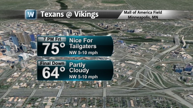
Insert Vikings Horn HERE...
It's that time of the year again! SKOL VIKES!! First preseason game of the year scheduled for Friday night and the weather looks pleasant for anyone heading downtown.
Stormy Situation
The weather pattern remains active in this persistent northwesterly flow. Looking out over the next several days, I don't see the weather pattern changing much and that's bad news for folks that have been inundated with major rains over the past several days. Thanks to Mike Price for the incredible lightning picture below out of Fayetteville, AR

Deadly Flooding
Unfortunately, the significant rainfall this week has been responsible for multiple fatalities. In both cases, it was due to cars being swept off the road! Here's a picture from Benton County, AR, where it appears a motorist found themselves in a pretty scary situation. Thanks to the Benton County EMA for the picture below

Major River Rises
Take a look at the Gasconade river gauge near Rich Fountain, MO; note the new record stage due to all the recent heavy rainfall! Note also the rapid increase in the river level since early this week! There were reports of some folks at a campground in Hollister, Missouri that had to be rescued because of major river rises. YIKES!

2012 Flood Fatalities
On average, floods claim more than 100 lives per year, nearly 50% are vehicle-related. Last year there were only 29 flood related fatalities, but the previous 2 years there were more than 100! The graph below shows the 2012 U.S. flood fatalities activity of victims, note that more people died while driving vs. anything else.
Read more Flood Safety Tips HERE:

More Flooding
Not only have we seen incredible flooding in the Central Plains, but folks in the Tennessee Valley are getting in on the action too! The picture below from RandomRon out of Nashville, TN shows the extensive flooding in what looks like a parking lot/lake.

Radar Estimated Rainfall
According to NOAA 7 day radar estimated rainfall, part of Missouri have seen 10" to 15"+ rainfall! No surprise that we've had as much flooding as we've seen with all that rain! YIKES!!

Missouri Drought Impacts?
In any other case, this rain would help with the drought situation, but prior to all this extensive rainfall, the drought situation in Missouri was minimal to null in spots that got all the rain.

August Rainfall
Since the beginning of August, there have been some incredible rainfall amounts in the central part of the country. Some of the bigger reporting stations are boasting some pretty decent numbers. Take a look at the numbers below!

Central Plains Drought Impacts
The rainfall is good news for some as these are areas that are in desperate need of moisture, especially closer to the Front Range of the Rockies. The latest drought update from the U.S. Drought Monitor, shows some improvement over the area, but we still need more to wipe the drought out completely.

Kansas Drought Impacts
Kansas has been getting some impressive rainfall over the past several days and according to the U.S. Drought Monitor, we've seen some decent improvements in the central and eastern part of the state. The western part of the state is still in desperate need of moisture.

Thursday is Drought Update Day
Every Thursday, the U.S. Drought Monitor updates its outlook and from this week to last, there wasn't any major changes. The western half of the nation is still in a big drought while the eastern part of the nation is not currently dealing with major drought conditions.
"The Plains: Another week of very heavy rain amounts over much of Kansas allowed for a full category improvement of much of the drought status in the state, especially in the central and east. Some counties reported several stations with 5+ inches of rain for the week. Not all areas of Kansas received the beneficial rains as most of western Kansas missed out again this week. Farther to the north, D0 was removed from portions of southeast Nebraska and D2 was improved to D1 in southern Nebraska. In northern portions of Nebraska, a full category improvement was made along the border with South Dakota, and in western Nebraska, D3 was improved and D4 removed. South Dakota also had several areas improve, including a full category improvement in southern portions of the state as well as into western counties. In northeast South Dakota, D0 was expanded because of short-term dryness. North Dakota had D1 introduced and D0 expand as short-term dryness has started to impact the region.
The West: Several areas of improvement took place in Colorado as the consistent rain has allowed for some green up of pastures and curtailed further degradation in many portions of the state. In southeast Colorado, D4 was improved, while D3 was improved in the southwest. In the north central portions of the state, D1 and D2 conditions were improved. Wyoming has had some areas improve this week as D0 was removed from the far northeast portions of the state while D1 was improved in the southeast. New Mexico had some adjoining areas to Colorado and Texas improved this week as the area received some scattered rain events. In central New Mexico, D4 conditions were improved as the short-term conditions improved. Improvements were also made in Arizona as many locations in the northern portion of the state had record to near record wetness for the month. In the north central portion of the state, D3 was improved to D2 and in the southeast, D2 and D1 were both improved. A large expansion of D3 conditions took place this week in Nevada, southwest Idaho, and eastern Oregon. In Oregon, D1 was expanded in the central portion of the state, and in Utah, an area of D2 was expanded where hydrologic issues are continuing.
Looking Ahead: Over the next five days (August 8-11) Temperatures will continue to remain below normal over most of the country, with departures of 6-9 degrees Fahrenheit anticipated over the Plains and West Coast. Above-normal temperatures are expected in the southern United States and the northern Rocky Mountains. A wet pattern is likely to continue over much of Colorado, Kansas, and Missouri and into Kentucky and Tennessee. The forecast is anticipating amounts of 3 inches over most of Kansas and western Kentucky. Dry conditions are projected over most of the western United States and into Texas.
The CPC 6-10 day forecast (August 11-15) anticipates the best chances for below-normal temperatures will be over the Plains, Midwest, and Northeast, with the best chances for below-normal temperatures in the Great Lakes region. The best chances for above-normal temperatures will be in the southern United States, Pacific Northwest and Alaska. Most of the country has above-normal chances of recording above-normal precipitation during this time frame. The greatest chances of above-normal precipitation will be over the Southeast. The Great Basin, Southwest, and most of Texas have the best chances of recording below-normal precipitation for the period."
Read more from the U.S. Drought Monitor HERE:

Yearly Precipitation From Normal
No surprise that after looking at the map below why such drought conditions are in place. It's remarkable to see such a divided nation; extremely dry in the west, while some folks in the east are extremely wet!

Additional Heavy Rain Potential
NOAA's HPC 5 day rainfall forecast still suggests an additional 1" to 3"+ possible for some in the central part of the country and for parts of the Ohio and Tennessee Valley. We've already had significant rainfall in some of these spots and we don't need anymore! Note also how the precipitation forecast curves into the Northeast. This precipitation is developing along the leading edge of cooler air. This 'cooler' air is still running below average and it looks to continue over the next several days.

Cooler Weather Continues...
The northeastern corner of the nation will continue to slightly below normal temps due to a persistent area of low pressure over the Hudson Bay. This continues area of counter-clockwise circulation is sending in frequent waves of chilled Canadian air that doesn't show any signs of slowing down anytime soon.

Friday's High Temps
Temps in the northeastern corner of the nation will still be a little cooler than average, but for those in the deep south, temperatures will continue to be well above average!

Friday Highs From Normal

Thanks for checking in and have a great weekend ahead!
Don't forget to follow me on Twitter @TNelsonWNTV

No comments:
Post a Comment