83 F. high in the Twin Cities Thursday.
83 F. average high on August 1.
92 F. high on August 1, 2012.
9 days at or above 90 F. this year at KMSP.
13 days at or above 90 F. during an average summer in the Twin Cities.
31 days at/above 90 F. during 2012.
"Aug-tember"
If this keeps up I may have to fly to
Greenland,
or possibly Fairbanks, Alaska to warm up. 30 days above 80F at
Fairbanks so far this year, and counting. The same persistent kink in
the jet stream steering winds pushing record warmth into Alaska and
western Canada is nudging a family of cool fronts into the northern USA.
Maybe I'm getting senile - or the Doppler is
frying my brain, but what's not to like about this weather pattern? Blue
sky, low humidity, no severe storms churning overhead? Go ahead and
unplug the A/C. You won't need it looking out the next 2 weeks.
While wildfires rage out west and persistent
T-storms soak the south some of the best weather in America will be
floating overhead into the weekend. A reinforcing puff of Canadian air
may spark a lonely shower tonight, but a dry sky spills over into the
weekend, highs in the mid to upper 70s. No drama.
Showers & T-storms return early next week,
followed by another swipe of September-like air late next week. If
you're heading north you'll need a few sweatshirts.
Keep the cool fronts in perspective. In my
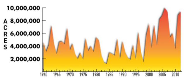
weather blog (below): U.S. wildfires in 2012 burned an area greater than
New Jersey, Delaware & Connecticut combined.
2013 will be worse.
"...
At a Senate hearing in June, United States Forest Service
Chief Thomas Tidwell testified that the average wildfire today burns
twice as many acres as it did 40 years ago. "In 2012, over 9.3 million
acres burned in the United States," he said – an area larger than New
Jersey, Connecticut and Delaware combined..." - from a Rolling Stone article; details below. Image: NOAA.
In Search Of The Dog Days. More like puppy days -
fairly anemic warmth (maybe a few low 80s early next week?) but
certainly nothing that would qualify as "hot" looking out 1-2 weeks. A
few showers and T-storms are possible by Monday and Tuesday, another
push of cooler air toward the end of next week, when highs may hold in
the 60s up north. ECMWF highs above in Celsius. But you probably already
figure that out.
Saturday Jet. 500 mb winds midday Saturday show a
weak split flow over North America, a very active northern branch to the
steering winds guiding record warmth into Alaska and western Canada,
while unusually chilly air over eastern Canada breaks off little chunks,
keeping the Upper Midwest, Great Lakes and New England cooler than
average for early August. Meanwhile the southwest continues to bake. Map
credit: Weather Bell.
5-Day Rainfall Outlook. The latest NOAA QPF into
next Wednesday shows a big, wet bulls-eye over Kansas City, where some
3-4" rains are predicted. Heavy showers and T-storms flare up along the
boundary separating cooler, Canadian air over the northern tier states
from blast-furnace heat over the south and west. The tropics are still
quiet.
Who Turned Off The Heat? The map above shows a
week's worth of 24 hour records: rainfall records, highs and lows as
well; over 2,000 between July 25 and August 2. Map above courtesy of Ham
Weather. Here's a breakdown:
| Total Records: |
2131 |
| Rainfall: |
462 |
| High Temp: |
42 |
| Low Temp: |
563 |
| Low Max Temp: |
957 |
| High Min Temp: |
107 |
July Climate Recap. The Twin Cities ended the month slightly milder and drier than average. Details from the Twin Cities
National Weather Service: "
July
of 2013 finished cool, but overall temperatures were near normal across
the region. The big story in July was the much drier pattern for
portions of the area. While the Twin Cities was near normal for
precipitation, both St. Cloud and Eau Claire had significant deficits."
* The Minnesota State Climatology Office and DNR has a great recap of July across Minnesota
here.
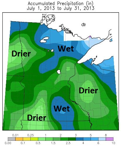
Fickle July Rainfall Pattern.
Last month was wetter than average from the southwest suburbs of the
Twin Cities to Albert Lea, and across much of the northern third of
Minnesota. The driest pockets: western Wisconsin, far southwest
Minnesota and portions of the Red River Valley. Map:
Midwest Regional Climate Center.
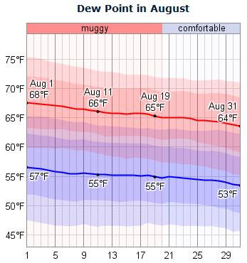
Dew Point Trends In August. Here's more potentially interesting information on August weather trends in the Twin Cities, courtesy of
WeatherSpark: "
Dew
point is often a better measure of how comfortable a person will find
the weather than relative humidity because it more directly relates to
whether perspiration will evaporate from the skin, thereby cooling the
body. Lower dew points feel drier and higher dew points feel more
humid. Over the course of a typical August, the dew point typically
varies from 53°F (very comfortable) to 68°F (muggy) and is rarely below 46°F (dry) or above 75°F (very muggy)."
Heading Into Peak Wildfire Season And Tinder-Dry In The West.
I have a bad feeling about the potential for more major fires out west
in the coming months. The trends are unmistakable, and much of the west
(much) drier than average for early August. This sets the stage for
potentially explosive fires during peak season, which runs from late
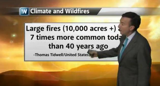
August into October. In today's edition of
Climate Matters
we look at why conditions are ripe for another active and potentially
destructive year of (larger, more destructive) fires out west: "
Rainless
in Seattle for July? Yes, many areas in the west had their driest July
on record. Not good news for the outlook for Western wildfires.
WeatherNation Chief Meteorologist Paul Douglas looks at why wildfires
are larger and more extreme than 40 years ago."
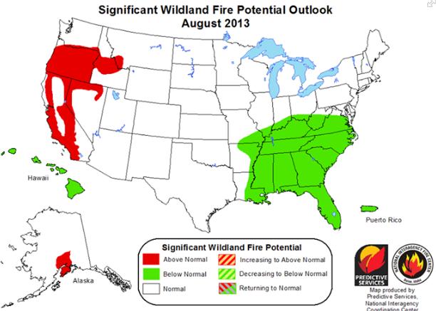
August Significant Wildfire Potential. Here's an explanation from
The National Weather Service Western Region HQ: "
NIFC
Predictive Services has updated their Significant Wildland Fire
Potential Outlook for August through November 2013. Significant fire
potential remains above normal for a large portion of the Pacific
Northwest and the mountains of California. The executive summary can be
found here: http://go.usa.gov/jPJJ"
Greenland Soars To It's Highest Temperature Ever Recorded, Almost 80F. The Capital Weather Gang has the story - here's a clip: "
The Danish Meteorological Institute is reporting
that on Tuesday, July 30, the mercury rose to 25.9 C (78.6 F) at a
station in Greenland, the highest temperature measured in the Arctic
country since records began in 1958. The balmy reading was logged at the
observing station Maniitsoq / Sugar Loaf, which is on Greenland’s
southwest coast, the DMI reports. It exceeded the 25.5 C (77.9 F)
reading taken at Kangerlussuaq on July 27, 1990, in the same general
area. Mantiitsoq is Greenland’s sixth-largest town, with a 2010
population of 2,784..."
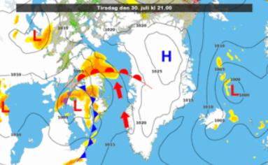
Graphic credit above: "
Weather pattern responsible for record warmth in southwest Greenland." (Danish Meteorological Institute).
China Swelters In Record Heat Wave. Details from
globalnews.ca: "
It’s
been so hot in China that folks are grilling shrimp on manhole covers,
eggs are hatching without incubators and a highway billboard has
mysteriously caught fire by itself. The heat wave – the worst in at
least 140 years in some parts – has left dozens of people dead and
pushed thermometers above 40 degrees C (104 F) in at least 40 cities
and counties, mostly in the south and east. Authorities for the first
time have declared the heat a “level 2″ weather emergency- a label
normally invoked for typhoons and flooding..."
Photo credit above: "
In this photo taken on Wednesday,
July 31, 2013, a child demonstrates how raw shrimp and an egg are fried
in a pan on a manhole cover on a hot summer day in Jinan in east
China's Shandong province. It’s been so hot in China that folks are
grilling shrimp on manhole covers, eggs are hatching without incubators
and a highway billboard has mysteriously caught fire by itself. The
heat wave — the worst in at least 140 years in some parts — has left
dozens of people dead and pushed thermometers above 40 degrees C (104
F) in at least 40 cities and counties, mostly in the south and east." ( AP Photo)
Alaska Heat Wave: Anchorage Sets Record For Most Consecutive 70-Degree Days. My good friend and meteorologist Jason Samenow has the details at The Washington Post's
Capital Weather Gang; here's an excerpt: "...
In
addition to the record-breaking 70-degree streak, Anchorage is closing
in on the most 70-degree days logged over an entire summer. It has 38
so far, compared to the record of 49 from 2004. To its north, Fairbanks
has also been unseasonably warm. Reports the Associated Press:
[T]emperatures Monday reached 80 or higher for the 29th day this
summer. The record is 30 days of 80 degrees or higher, set in 2004.
Consider Fairbanks averages just 11 80-degree days per summer (compared
to this year’s 29, already)..."
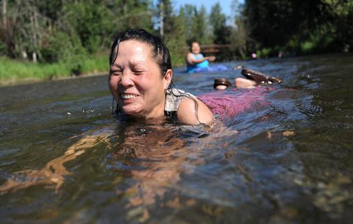
Photo credit above: "
Kan Kil floats face-first in the cool
waters of Campbell Creek, near Lake Otis Parkway, while beating the
heat on Tuesday, July 30, 2013. Anchorage broke a record on Tuesday
for hitting 70 degrees or more for the 14th straight day." (AP Photo/Anchorage Daily News, Bill Roth)
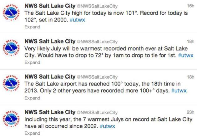
More unusual weather across the USA. Too hot across Utah:
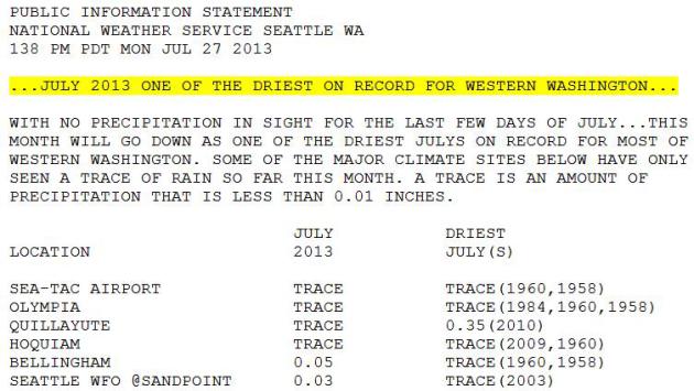
Meanwhile it's too dry over much of the Pacific Northwest, including Washington State:
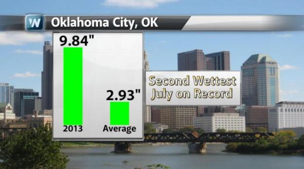
Tell that to residents of Oklahoma City:
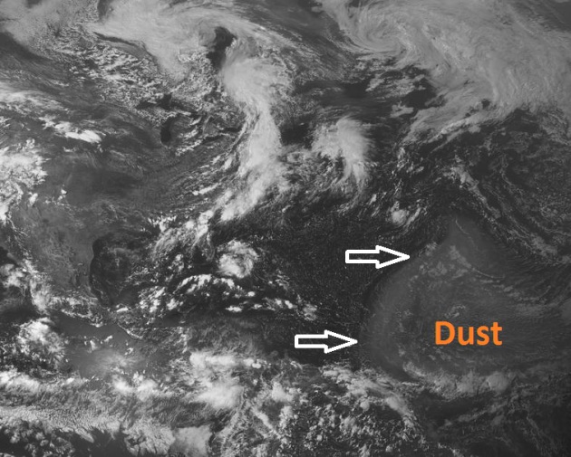
Saharan Dust Discouraging Tropical Storm Formation.
There's probably a good reason why tropical development has slowed in
recent weeks - too much wind shear, and too much dust from Africa.
The Baltimore Sun has a good explanation about what's really going on; here's an excerpt: "
The
peak of hurricane season is approaching later this month, but storm
activity in the middle of the Atlantic is unlikely to develop during
the first half of August because of a massive cloud of dust from the
Sahara Desert moving across the ocean. Satellite images from earlier
this week (shown above) revealed a burst of dust blowing westward off
of Africa. NASA Global Hawk aircraft were scheduled to explore the dust
further on Tuesday. Saharan dust can significantly discourage tropical
cyclone formation in the Atlantic, according to National Oceanic and
Atmospheric Administration scientists. It typically brings dry air that
is not conducive to storm development, and some studies have suggested
the dust itself has an effect on cloud formation..."
Image credit above:
Ham Weather.
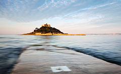
Rare UK Tsunami Was Caused By A Storm. This one made me do a double-take; details from the UK's
Planet Earth Online: "
The
meteotsunami, which reached around half a metre in height was
originally thought to have been caused by a landslide. But a new report,
published in Weather, suggests the origin actually lay with some
thundery storm cells with a starting point over 300 miles away in the
Bay of Biscay. Weather tsunamis like this have been known to occur in
the Mediterranean, where they can cause significant damage to coastal
infrastructure, and in Japan where they have been known to result in
death. But this wave travelled from Portugal to Brittany and then into
the English Channel, making it the first meteotsunami to be positively
identified in Britain, Spain and France..."
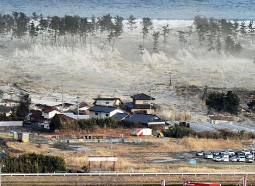
Japan Prepares For 9-Magnitude Earthquake And Tsunami. A "9" on the Richter scale is almost unimaginable, but Japan is taking it seriously.
Business Insurance has the story: "
The
Japanese government expects a 9-magnitude earthquake to hit the Nankai
trough in the southern Pacific side of the main Honshu island followed
by a tsunami, reported Channel News Asia. These calamities are expected
to kill up to 320,000 people and cause economic damage of more than
$2.2 trillion, worse than the March 2011 earthquake and tsunami.
Several cities and towns are preparing for the worst-case scenario, and
the government is looking to come up with an action plan by the end of
July to mitigate risk of fatalities.."
File photo above:
The Telegraph.
Cost Of Storm Damage Will Rise Sharply, Even Without Climate Change.
Some of this comes down to demographic trends, more people wanting to
live near water (oceans and rivers that often flood). Here's a clip from
a story at
Scientific American: "
Extreme
weather could cause four times as much economic loss in the U.S. by
2050 as it does today—without any increase in the frequency or
intensity of hurricanes, tornadoes or lightning. That is because the
population will be larger and richer and because more Americans are
moving to the Eastern seaboard, the Gulf Coast and other storm-ridden
places. The frequency of natural hazards varies across the country
(top), but nationwide, average annual losses from all of them over the
past 50 years amounted to $10 billion to $13 billion (not including
business disruption). By 2050 the price tag will double in many
counties, and in some it will swell by four or six times or more
(bottom), according to Benjamin L. Preston, deputy director of the
Climate Change Science Institute at Oak Ridge National Laboratory. The
highest increases will be driven mostly by rising population. If
society is concerned about future risk, Preston says, it has to pay
closer attention to where people are migrating..."
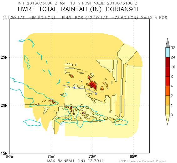
NOAA's New Supercomputers Mean Better Storm Tracking, Officials Say.
Here are some specifics on NOAA's new supercomputer upgrade. I'm hoping
that GFS and the new HWRF hurricane model outperform ECMWF. Here's a
clip from
Nature World News: "...
These
upgrades are a game-changer for the entire public and private weather
industry," Louis W. Uccellini, director of NOAA's National Weather
Service, said in a press release. "In addition to the benefits to our
own forecasters and products, we will provide our private sector
partners with better information to empower them to enhance their
services." Nicknamed "Tide," the supercomputer located in Reston, Va.,
along with its Orlando-based backup named "Gyre," are operating with
213 teraflops (TF), versus the 90 TF with which is operated at. As a
result, the National Weather Service can now implement an enhanced
Hurricane Weather Research and Forecasting (HWRF) model that, according
to US Sen. Bill Nelson, could save lives..."
Wind Farms Get More Accurate Weather Forecasts.
Urbantimes.com has an interesting story with a local angle; here's an excerpt: "
When
you’re running an electricity grid, the more renewable power you have
in your mix, the more you fear unexpected ‘wind ramp events’.
Tornadoes, ice storms or other extreme weather events can interrupt the
spin of wind turbines, so that you have to ramp up baseload generation
to meet demand. Highly-tuned next-day probabilistic forecasts for each
precise location would let you integrate wind power more aggressively
into your supply-side balancing act. Which is just what US utility Xcel Energy will be getting from the National Center for Atmospheric Research (NCAR).
Under a new two-year programme, a variational Doppler radar analysis
system will combine radar data with computer simulations to forecast the
weather conditions for individual wind farms. Xcel’s regional control
centres can integrate these forecasts with a growing body of data on
past output performance, for a much better indication of how much power
the grid can count on from a source..."
Photo credit above: Robert East.
Be Careful What You Plug Into Google. Just the right
(wrong) combination of search keywords, and you too may find agents
showing up at your front door, especially if you Google "pressure
cookers". Here's an excerpt from a must-read story at
medium.com: "...
But
my son’s reading habits combined with my search for a pressure cooker
and my husband’s search for a backpack set off an alarm of sorts at the
joint terrorism task force headquarters. That’s how I imagine it
played out, anyhow. Lots of bells and whistles and a crowd of task
force workers huddled around a computer screen looking at our Google
history..."
* Then again the whole pressure cooker/Google story may have been made up, according to
The Washington Post. I'm still going to be careful what I plug into Google, just in case.
Researcher: U.S. To Devour More Media Digitally Than On TV. CNET News has the story; here's a clip: "...
Average time spent with digital media per day will surpass TV-viewing time for the first time this year, researcher eMarketer estimated in a report Thursday.
That's largely because the total amount of time spent with media has
increased every year, though daily digital media consumption is expected
to rise 16 percent this year versus a slight decline in TV consumption
of less than 3 percent. Most of the increase in digital viewing is on
mobile devices, which are quickly becoming the go-to place to watch
entertainment. According to the estimates, the average U.S. adult will
spend 5 hours and 9 minutes a day online on nonvoice mobile activities
or with other digital media this year, compared to 4 hours and 31
minutes watching television..."
Image credit above:
Sarah Tew/CNET.
*
NPR
reports on the dwindling handful of countries around the world that
don't have a McDonalds. How do the locals survive in places like
Cambodia?
California To Get America's Fastest High-Speed Rain Line. So maybe in a few years we'll catch up to the Europeans and Japanese? Encouraging news from gizmag.com; here's an excerpt: "When
people grumble about how they think the US isn’t as technologically
advanced as it should be, they like to bring up bullet trains – Europe
and Asia have them, so why doesn’t America? Well, it’s getting one. Work
is starting this summer on a high-speed rail line running from San
Francisco to Los Angeles, that will carry a passenger train traveling at
over 200 mph (322 km/h)..."
The Hottest Trends In Boomer Travel. Showing my age,
I know. A reluctant baby boomer. Gen-X sounds like more fun, come to
think of it. But my wife of 29 years and I love to travel, especially
winter months (imagine that), and this story at PBS
Next Avenue caught my eye; here's an excerpt: "...
While
it’s hard to make generalizations about 78 million individuals
(especially this trailblazing demographic), pundits do point to certain
trends among boomer travelers. To give you some inspiration for the
3.7 statistical trips you’ll take in the next year, here are seven of
the hottest trends among our peers.
1. Ecotourism Green is the new black when it comes to
vacations. The U.N. World Tourism Organization predicts there will be
some 1.6 billion eco-inspired trips taken by 2020. But all operators are
not created equal. It’s important to do your homework and find a
company that works closely with local residents to benefit them. True
ecotourism isn’t just zip-lining through the jungle. It helps the local
economy and is sustainable. An important fringe benefit: Local
residents come to appreciate the inherent value of their natural
resources — rain forests, nature preserves, waterways, coral reefs —
and realize that they must be protected and preserved..."
13+ Things You Shouldn't Eat At A Restaurant. Not my list, but an excerpt from an interesting read at Readers Digest; here's an excerpt:
1. Meat with the Bone In
Small cuts of meat, like bone-in pork or chicken breasts, are harder to
cook thoroughly because their outsides easily char. This often
translates to crispy on the outside and raw on the inside. Unlike
undercooked beef—say, a rare burger or a steak tartare—undercooked pork
and chicken are highly dangerous and could causes food-borne
illnesses.
Plus, bone-in means less meat...
Photo credit above: iStockphoto/Thinkstock.
TODAY: Periods of sunshine, still comfortable. Dew point: 53. Winds: N/NW 5-10. High: 78
FRIDAY NIGHT: Patchy clouds, isolated shower possible. Low: 59
SATURDAY: Sunny, cool for August. Dew point: 52 Winds: N 10. High: 76
SUNDAY: Plenty of sun, a bit milder. Winds: S 5-10. Wake-up: 56. High: 77
MONDAY: Warmer, T-storms north. Dew point: 61. Wake-up: 60. High: near 80
TUESDAY: Sticky, lingering T-storms. Dew point: 64. Wake-up: 64. High: 82
WEDNESDAY: Breezy, cooler and drier with intervals of sun. Wake-up: 61. High: 77
THURSDAY: More clouds, few showers. Brisk! Wake-up: 57. High: 71 (60 up north)
Climate Stories...
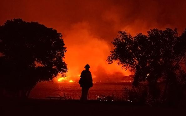
The Great Burning: How Wildfires Are Threatening The West.
No, it's not your imagination. Fire season is pretty much yearround now
west of the Rockies. Here's an excerpt of an eye-opening article at
Rolling Stone: "...
But
the United States is facing an even more basic question: How should we
manage fire, given the fact that, thanks to climate change, the
destruction potential for wildfires across the nation has never been
greater? In the past decade alone, at least 10 states – from Alaska to
Florida – have been hit by the largest or most destructive wildfires in
their respective histories. Nationally, the cost of fighting fires has
increased from $1.1 billion in 1994 to $2.7 billion in 2011. The line
separating "fire season" from the rest of the year is becoming blurry. A
wildfire that began in Colorado in early October continued smoldering
into May of this year. Arizona's first wildfire of 2013 began in
February, months ahead of the traditional firefighting season. A
year-round fire season may be the new normal..."
Photo credit above: Gene Blevins/Reuters/Landov.
Extreme Wildfires Likely Fueled By Climate Change. Here's a summary of new research at
Michigan State University: "
Climate
change is likely fueling the larger and more destructive wildfires that
are scorching vast areas of the American West, according to new
research led by Michigan State University scientists. These erratic
fires are harder to contant and often result in catastrophic damage and
loss of property and life. Although not analyzed in the study, the
recent Arizona wildfire that began with a lightning strike and killed 19
firefighters appeared to be such an unpredictable, fast-spreading
blaze, according to a state report. The MSU-led study, which appears in
the Journal of Applied Meteorology and Climatology, predicts the trend
will continue in the western United States. "Our findings suggest that
future lower atmospheric conditions may favor larger and more extreme
wildfires, posing an additional challenge to fire and forest
management," said Lifeng Luo, MSU assistant professor of geogrphay and
lead author on the study..."
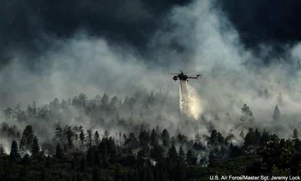
Photo credit above: U.S. Air Force - Master Sgt. Jeremy Lock.
A Nation On Fire: Climate Change And The Burning Of America. Here's an excerpt from a story at
Climate Progress: "...
Scientists
and fire experts speaking on a recent conference call organized by the
Union of Concerned Scientists say the nation is moving into an era
when massive and destructive wildfires of the kind that occurred only
sporadically over the last century will now be a regular occurrence.
“Within the next few decades we anticipate these [forest] systems being
as dry on a regular basis as the major fire years of the last
century,” said Anthony Westerling of the University of California,
Merced. “We are now completely certain that there is a climate signal in
the observed fire activity,” added Dave Cleaves, climate adviser to
the head of the U.S. Forest Service. “Fire, insects, disease and
moisture stress are all being linked more closely by climate change.”
Wildfire statistics
compiled by the National Interagency Fire Center in Boise, Idaho,
offer sobering confirmation. The seven largest fire years since 1960
have all occurred since 2000. In 2006, 2007, and last year, the toll
exceeded 9 million acres, an area roughly equivalent to Maryland and
Rhode Island combined..."
 A Republican Case For Climate Action
. Here's an excerpt of an Op-Ed from former EPA administrators who served Republican presidents at
The New York Times: "...
There
is no longer any credible scientific debate about the basic facts: our
world continues to warm, with the last decade the hottest in modern
records, and the deep ocean warming faster than the earth’s atmosphere.
Sea level is rising. Arctic Sea ice is melting years faster than
projected. The costs of inaction are undeniable. The lines of scientific
evidence grow only stronger and more numerous. And the window of time
remaining to act is growing smaller: delay could mean that warming
becomes “locked in....”
From The New York Times: "
The writers are former administrators of the Environmental Protection Agency: William D. Ruckelshaus, from its founding in 1970 to 1973, and again from 1983 to 1985; Lee M. Thomas, from 1985 to 1989; William K. Reilly, from 1989 to 1993; and Christine Todd Whitman, from 2001 to 2003."
Climate Disruption And Sea Level Rise. PRI,
Public Radio International, has the story (and audio); here's a clip: "...
Perhaps
no consequence of global warming is more immediately dangerous than
rising sea levels. Big ice sheets and glaciers in Greenland and the
Antarctic are giving out and melting away to become part of the
ocean. The question for climate researchers has not been whether sea
levels are rising, but how fast. New research from Germany's climate
research center, the Potsdam Institute, finds the rise to be about
seven feet for every degree Celsius of global warming. Of course, that
rise will be on a geographic timescale — perhaps thousands of years,
Levermann said. Anders Levermann, lead author of the report, which was
published in the Proceedings of the National Academy of Sciences, said
sea level rise can be attributed to four main factors..."
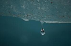
Photo credit above: "
A Norwegian glacier melts on August 1, 2012." (Photo by Flickr user ironpoison.)
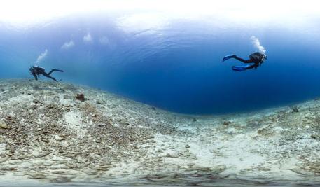
Caribbean Has Lost 80% Of It's Coral Reef Cover In Recent Years.
The Guardian has the story; here's the intro: "
A major survey of the coral
reefs of the Caribbean is expected to reveal the extent to which one
of the world's biggest and most important reserves of coral has been
degraded by climate change,
pollution, overfishing and degradation. The Catlin scientific survey
will undertake the most comprehensive survey yet of the state of the
region's reefs, starting in Belize and moving on to Mexico, Anguilla,
Barbuda, St Lucia, Turks & Caicos, Florida and Bermuda. The Catlin
scientists said the state of the regions' reefs would act as an early
warning of problems besetting all of the world's coral. As much as 80%
of Caribbean coral is reckoned to have been lost in recent years, but
the survey should give a more accurate picture of where the losses have
had most effect and on the causes..."
Photo credit above: "
As much as 80% of the Caribbean coral is thought to have been lost in recent years." Photograph: Catlin Seaview Survey.
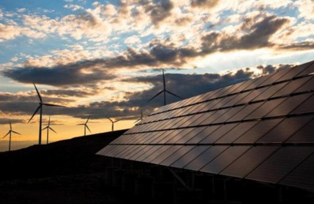
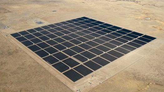
Australia To Get Southern Hemisphere's Largest PV Plant. PV, as in photovoltaic. Here's a clip from
gizmag.com: "
With
plenty of sun-drenched, wide open spaces, Australia is an obvious
place for large-scale solar power plants. It would seem that large
reserves of coal, oil and natural gas, have on the other hand made it
difficult for the country to wean itself off fossil fuels. But renewable
energy is getting a boost down-under with the announcement of two
solar projects, one of which will be the largest solar photovoltaic
(PV) plant in the Southern Hemisphere..."
Why The Peak Oilers Are Still Right. I don't pretend
to know whether we will have abundant supplies of (affordable) fossil
fuels for my kids and future grandkids, but this
Grist article caught my attention; here's a clip: "...
Readers
who’ve seen articles and TV ads proclaiming America’s newfound oil and
gas abundance may find it strange and surprising to learn that the
official forecast from the U.S. Energy Information Administration is
for America’s historic oil production decline to resume within this
decade. But the EIA may actually be overly optimistic. Once the peak
is passed, the agency foresees a long, slow slide in production from
tight oil deposits (likewise from shale gas wells). However, analysis
that takes into account the remaining number of possible drilling sites,
as well as the high production decline rates in typical tight oil and
shale gas wells, yields a different forecast: Production will indeed
peak before 2020, but then it will likely fall much more rapidly than
either the industry or the official agencies forecast. And there’s much
more to the story: shale gas wells that cost more to drill than their
gas is worth at current prices; Wall Street investment banks that drive
independent oil and gas companies to produce uneconomic resources just
so brokers can collect fees; official agencies that have overestimated
oil production and under-estimated prices consistently for the past
decade..."
Image credit above: Shutterstock.
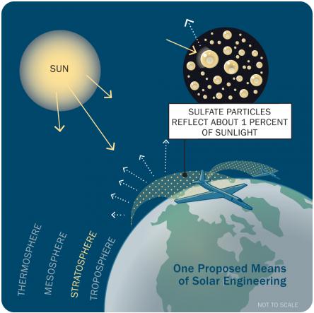
Buffering The Sun. Is geo-engineering a prudent
course of action to mitigate and diminish the negative impacts of
climate change, or an example of scientific hubris which may have some
very unpredictable and potentially unpleasant side effects? Check out
this article at
Harvard Magazine; here's a clip: "...
Keith
speaks candidly about the risks and uncertainties of solar
geoengineering, acknowledging a range of possible outcomes. “The balance
of evidence so far suggests that solar geoengineering could reduce
climate risks, but early science might be wrong,” he says. “We need
experiments, which might show that it does not work.” Additionally, some
research suggests that sulfate aerosols may further damage the ozone
layer, an issue that he says needs further study. Alan Robock, professor
of environmental sciences at Rutgers, is one critic who has raised
other concerns, theorizing that sunlight-blocking strategies could not
only reduce the amount of electricity produced through solar power but
also alter weather patterns, which might trigger widespread droughts.
Keith does not find these possibilities convincing. He believes solar
energy would be affected only in “extreme scenarios” with very heavy
use of solar geoengineering, and he says he has not seen serious
analysis that supports the possibility of drought..."
Graphic by Funnel, INC.











No comments:
Post a Comment