Monday Record Highs:
97: Twin Cities (old record 94 in 1948)
95 St. Cloud (old record 93 in 2003)
94 Alexandria (old record 93 in 1976)
97 F. record high Monday in the Twin Cities. Old record was 94 F. on August 26, 1948.
97 F. high reported at Appleton and Red Wing, Minnesota yesterday.
79 F. average high for August 26.
86 F. high on August 26, 2012.
+1 F. August temperatures are running 1 F. warmer than average, to date.
13% based on NWS Cooling Degree Days we've spent 13% more to cool our homes and businesses than average since June 1.
Excessive Heat Warning in effect again today (last day of dangerous heat).
Late Summer Sizzle - Real Relief By Labor Day
I'm thinking of flying to Palm Springs to cool
off - and torture my golf clubs. It was 15F degrees cooler in the
deserts of southern California than it was in Minnesota yesterday. Two
record highs in a row, but slight relief is likely by Thursday (with a
good chance of T-storms and some badly needed rain).
ECMWF "Euro" guidance is hinting at a push of
much cooler air coming sooner than expected; a big drop in
temperature/dew point by Sunday and Labor Day.
And now comes word that the 2014 Farmer's
Almanac is predicting a very cold winter for much of the USA - and an
ominous prediction for the February Superbowl at New Jersey's (outdoor)
Meadowlands stadium. What can possibly go wrong? I have my bootleg copy,
but don't bet the farm based on a 6-9 month weather prediction. If
anything we may be limping into a mild El Nino, which could temper the
coldest winds of winter.
T-storms may pop up north again today - southern Minnesota stuck under a heat dome with more mid/upper 90s.
I'm having a deja vu moment: it's drying out
nearly as fast as 2012. Let's not whine about rain anytime soon. The
best chance: Thursday and late Saturday.
A welcome taste of autumn arrives next week.
Latest 80-degree Low Temperature On Record In The Twin Cities: Details from the Twin Cities NWS:
THE LOWEST TEMPERATURE (MONDAY) HAS BEEN 80 DEGREES IN THE TWIN CITIES.
THIS TIES THE WARMEST LOW TEMPERATURE FOR THE MONTH OF AUGUST.
THIS IS THE LATEST 80 DEGREE LOW TEMPERATURE IN THE TWIN CITIES.
THE OTHER AUGUST 80 DEGREE LOW TEMPERATURES FOLLOW...
AUGUST 2 1955...80 DEGREE LOW.
AUGUST 6 2001...80 DEGREE LOW.
AUGUST 10 1944...80 DEGREE LOW.
AUGUST 22 1968...80 DEGREE LOW.
AUGUST 25 2013...80 DEGREE LOW...YESTERDAY
AUGUST 26 2013...80 DEGREE LOW...ALSO LATEST 80 DEGREE LOW EVER.
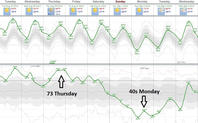
Relief 5 Days Away? The ECMWF model (courtesy of
Weatherspark) shows muggy conditions into Friday, a cool frontal passage
pumping drier, Canadian air into Minnesota Sunday and Monday as dew
points drop into the 40s. If the "Euro" is to be believed highs may hold
in the 70s by Labor Day.
Drought, Frost Among Farmers' Crop Concerns. The Gazette
has the story - here's an excerpt: "The expanding drought has taken
precedence of the "F" word, frost, as the leading threat to Iowa
farmers' crops. "
Farmers are talking about both drought and frost.
An early frost absolutely matters in a year of late crop development,
but it feels farther away when the weather turns hot." Bill Northey,
secretary of the Iowa Department of Agriculture and Land Stewardship,
said Thursday. "Heat will be the big difference maker now," said Brian
Fuchs, one of the authors of the U.S. Drought Monitor, which in its
latest report Thursday showed dry soils expanding in Iowa..."
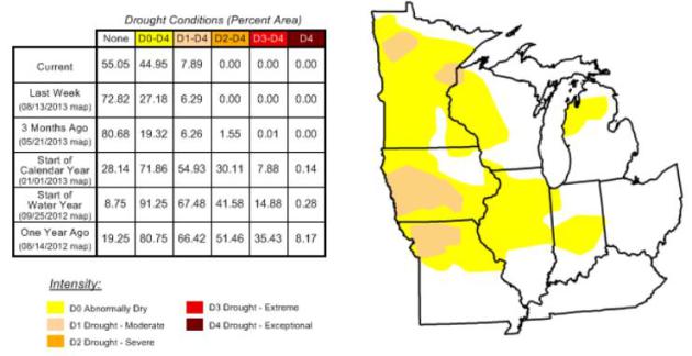
* latest U.S. Drought Monitor for the Upper Midwest
here.
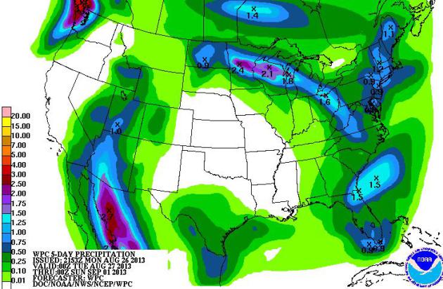
5-Day Rainfall. It's amazing how fast Minnesota is
drying out now - corn and bean fields under obvious stress. Just like
August of 2012 rainfall has (almost instantly) become spotty and sparse,
more rain for northern Minnesota and Wisconsin, but precious little
rain for farms in central and southern portions of both states. We need
rain (badly). NOAA HPC hints at some 2"+ amounts over northern
Minnesota, but very little rain over far southwest Minnesota into
Sunday.
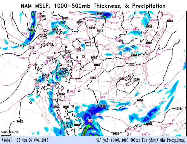
"Ridge Riders". More T-storms will flare up along
the northern boundary of a very slow moving heat bubble over the Upper
Midwest, the best chance of some badly needed rain Thursday. Cooler air
is building over Canada, relief that will finally sweep across the
northern tier of the USA early next week. 84 hour NAM loop: NOAA.
The expanding drought has taken precedence over the “F” word, frost, as the leading threat to Iowa farmers’ crops.
“Farmers are talking about both drought and frost. An early frost
absolutely matters in a year of late crop development, but it feels
farther away when the weather turns hot,” Bill Northey, secretary of
the Iowa Department of Agriculture and Land Stewardship, said Thursday.
“Heat will be the big difference maker now,” said Brian Fuchs, one
of the authors of the U.S. Drought Monitor, which in its latest report
Thursday showed dry soils expanding in Iowa.
- See more at: http://thegazette.com/2013/08/25/drought-frost-among-iowa-farmers-crop-concerns/#sthash.R2qGG5pS.dpuf
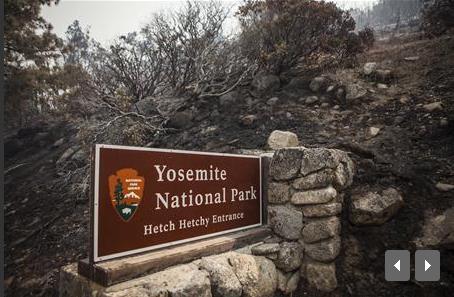
Yosemite Wildfire Grows, Fueling Dangerous Winds. Here's an excerpt of an update from
Reuters: "
A
colossal wildfire raging on the edge of Yosemite National Park has
produced dangerous weather patterns by fueling thunderous pyrocumulus
clouds that can alter the wind direction rapidly, potentially trapping
firefighters, forest officials said on Sunday. The
so-called Rim Fire grew to 134,000 acres by early Sunday morning, up
9,000 acres from the day before, with smoke columns rising more than
30,000 feet, said U.S. Forest Service spokesman Dick Fleishman.
"That's a real watch-out situation for our firefighters when they see
that kind of activity, they know that the wind could actually move that
fire right back on them," Fleishman said. "That's been happening every
afternoon..."
Photo credit above: "A sign on the edge of Yosemite National Park, California, is surrounded by a burn from the Rim Fire, August 23, 2013." REUTERS/Max Whittaker.
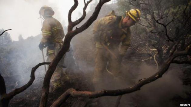
Wildfire Threatens San Francisco Power Grid.
The flames have threatened water supplies, reservoirs and hydroelectric
generators that provide electricity for San Francisco - here's an
excerpt from Voice of America: "
A
massive wildfire in northern California has swallowed up the western
edge of Yosemite National Park and is threatening the city of San
Francisco's water and power supplies. More than 2,600 firefighters are
battling the blaze, which is burning across about 52,000 hectares and
threatens 5,500 homes. Some towns have issued voluntary evacuations.
The governor of California called a state of emergency Friday for the
city of San Francisco, which is about 240 kilometers away from the
raging inferno. Two hydroelectric plants in the area were shut down due
to the fire..."
Photo credit above: "
Firefighters battle a blaze at Yosemite National Park, California, August 24, 2013." Reuters.
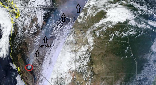
Giant Wildfire Chars 15,000 Acres Within Yosemite National Park, May Grown In "Extreme" Way. Here's more information on the near-record blaze for California from NBC News: "...NBC Bay Area reported that the Berkeley Tuolumne Family Camp
had been destroyed by flames. It said staff and campers were evacuated
beforehand and no injuries were reported. The camp dates to 1922. NBC Los Angeles noted
that the incident was closing in on the record-breaking 145,000-acre
wildfire that burned over a three-week period in 1987. At close to 225
square miles, the blaze is more than four times the size of San
Francisco. The fire was sparked last week in a remote canyon of the
Stanislaus National Forest, with arid conditions feeding the flames.
Statewide, more than 8,300 firefighters are battling nearly 400 square
miles of fires..." (Image: NASA MODIS, University of Wisconsin).
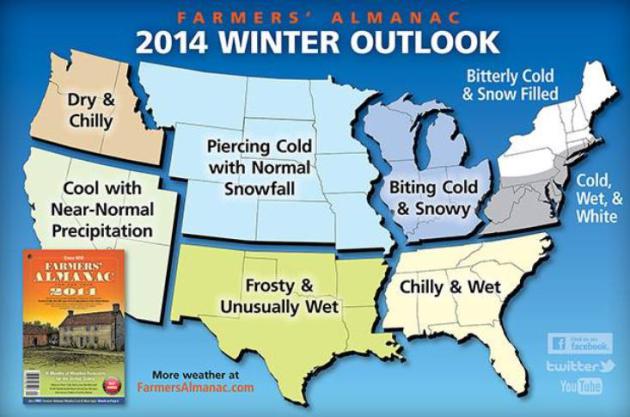
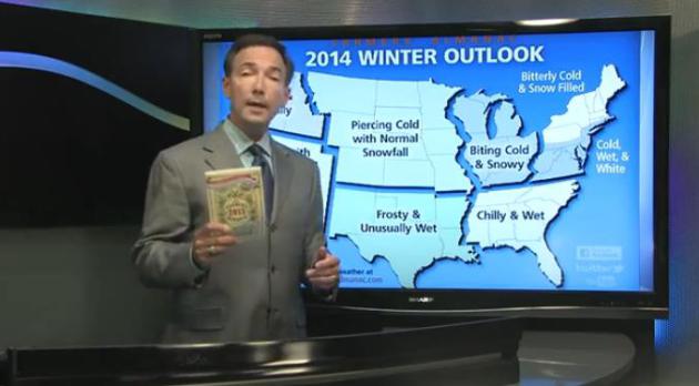
Farmers Almanac Predicts A "Bitterly Cold" Winter.
Stop the presses - we have the official forecast for the winter. It's
understandable to be curious about the winter-to-come, but buyer beware.
There's no scientific basis for this forecast, or if there is the
Farmers Almanac has yet to release the methadology of their long-range
predictions. Hey, I have a copy - there's great information in there,
but I'm not convinced they (or anyone else) has cracked the riddle of a
6-9 month forecast.
CBS News has the video and more details: "
The
Farmers' Almanac is using words like "piercing cold," "bitterly cold"
and "biting cold" to describe the upcoming winter. And if its
predictions are right, the first outdoor Super Bowl in years will be a
messy "Storm Bowl." The 197-year-old publication
that hits newsstands Monday predicts a winter storm will hit the
Northeast around the time the Super Bowl is played at MetLife Stadium in
the Meadowlands in New Jersey. It also predicts a colder-than-normal
winter for two-thirds of the country and heavy snowfall in the Midwest,
Great Lakes and New England. "We're using a very strong four-letter
word to describe this winter, which is C-O-L-D. It's going to be very
cold," said Sandi Duncan, managing editor. Based on planetary
positions, sunspots and lunar cycles, the almanac's secret formula is
largely unchanged since founder David Young published the first almanac
in 1818..."
* Friend, colleague and meteorologist Jason Samenow has more on the
Farmer's Almanac Outlook for winter and 2014, and a look back at how
well they did last winter at The Washington Post's
Capital Weather Gang.
** "
Note To CBS: This Is NOT News, It's Make Believe". Meteorologist
Dan Satterfield
has a sharp response to the desire to make this a big story. While
you're at it, can you tell me how the NASDAQ will be doing next
February?
More Horoscope Than Science?Hey,
I like the Farmer's Almanac. It's like seeing an old (slightly crazy)
friend every year. Truth: if you could accurately (consistently)
predict weather 6-12 months in advance you'd have Romney money, or
maybe even Elon Musk money. Billions. You'd be able to buy your own
island in the Caribbean. Thanks in large part to chaos theory and the
sheer complexity of the atmosphere, predicting precipitation or
temperature beyond 15-20 days is voodoo. It's equivalent to predicting
what the price of Apple stock will be on February 3, 2014. Good luck.
There's no skill. Zero. Sometimes an evolving La Nina or El Nino
pattern can tilt the odds in a certain direction and we can issue
trend forecasts "warmer in the east, drier in the west", but
specificity beyond a couple of weeks is wishful thinking. And basing a
long-range (weather) forecast on sunspots and other "factors"?
They've never released the methadology behind these 6-12 month
forecasts. Questionable at best. But as a source of interesting
weather nuggets and curious prognistications the Farmers Almanac is a
source of endless fascination. Disclaimer aside, the F.A. is
predicting a cold, snowy winter east of the Rockies. Uh huh. Details in
today's edition of Climate Matters: "WeatherNation
TV Chief Meteorologist Paul Douglas looks at the long-range weather
prediction just issued by the Farmer's Almanac. It forecasts a major
storm for the Northeast, just in time for the Superbowl (in the
outdoor Meadowlands stadium in New Jersey). Also, how common are the
most extreme heat waves going to be in coming years?"
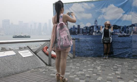
If It's Too Smoggy For Your Tourist Photos, Hong Kong Has A Fake Blue-Sky Background.
Well, here's one way to solve the horrifica air pollution problem
gripping much of China, as explained at Grist: "Air quality at Hong Kong
famously hovers somewhere between "technically breathable" and "mainly
motor oil with the occasional oxygen bubble". That's bad for people's
lungs, but more importantly, it's bad for their photos. Tourists didn't
pay good money to go to Hong Kong and have their vacation Instagrams
ruined by light-impervious smog. That's why the city has set up a
backdrop showing a skyling against a clear, blue, entirely fake sky..."
Photo credit: Alex Hofford/CFP.
Incredible Technology: How To Forecast Severe Storms. There's some good information in this story at
Live Science; here's an excerpt: "...
Forecasting a storm
is a lot like practicing medicine, said meteorologist Greg Carbin at
the National Oceanic and Atmospheric Administration's (NOAA) Storm
Prediction Center (SPC) in Norman, Okla. "You go to the doctor, you tell
the doctor your symptoms and the doctor makes a diagnosis before he
makes a prognosis," Carbin told LiveScience. "We need to diagnose the
current state of the atmosphere as best we can before we can attempt to
forecast." [Hurricanes from Above: See Nature's Biggest Storms]. The SPC is primarily concerned with forecasting thunderstorms and tornadoes in the continental United States..."
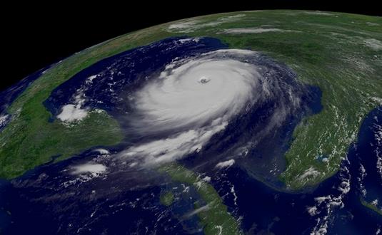
Image credit above: "NOAA's
GOES-12 weather satellites captured this image of Hurricane Katrina at
Category 5 strength on Aug. 28, 2005, at 11:45 a.m. EDT." Credit: NOAA.
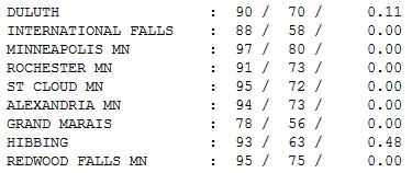
Hot Enough. Monday hights ranged from 78 at Grand
Marais to 95 St. Cloud, 97 in the Twin Cities. Nearly half an inch of
rain fell at Hibbing, almost 2.5" at Hayward, Wisconsin over the last 24
hours.
TODAY: Excessive Heat Warning. Free sauna with
more hot sun. T-storms central and northern MN. Dew point: 71 Heat
Index: 105. High: 96
TUESDAY NIGHT: Still warmer than average, not quite as sticky. Low: 74
WEDNESDAY: Slight dip in humidity, "cooler". Plenty of sun. Dew point: 65. High: 92
THURSDAY: Unsettled with scattered T-storms. Dew point: 69. Wake-up: 73. High: 88
FRIDAY: Intervals of sun, good lake day with lot's of sun. Wake-up: 71. High: 93
SATURDAY: Some sticky sun, passing T-storm. Wake-up: 73. High: near 90
SUNDAY: Sunny, cooler, less humid. DP: 60. Wake-up: 69. High: 86
LABOR DAY: Blue sky, September-like. DP: 52. Wake-up: 61 (50s in the suburbs). High: 76
Climate Stories....
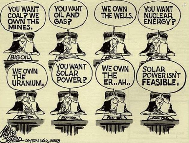
”Science is what we do to keep from lying to ourselves” - Richard Feynman.
Cartoon credit: Mike Peters,
Dayton Daily News.
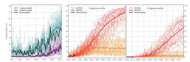
"3 Sigma" Heat Waves To Increase In Coming Decades. Here's an excerpt from a
recent paper
which shows a doubling of (extreme) heat waves by 2020, a possible 4X
increase by 2040. The frequency and intensity of future heat will depend
on whether we can (globally) reduce greenhouse gas emissions. Here's an
excerpt: "...
We show that the frequency of summer months with
extreme heat (3-sigma) and unprecedented heat (5-sigma) will strongly
increase under expected future global warming. Even strong mitigation
(RCP2.6) cannot stop the increase in occurrence-frequency of 3-sigma
heat by a factor four in the near-term. Also, 5-sigma events will emerge
and become common in some tropical regions. Mitigation, however, can
strongly reduce the expected number of heat extremes in the second half
of the 21st century..."
Graphic credit above: "
Percentage of global land area
during boreal summers with monthly temperatures beyond different
sigma-thresholds for historic (left) and 21st century (middle and
right). The CMIP5 multi-model mean (thick colored lines) accurately
reproduces the observed increase in 1, 2 and 3-sigma extremes in the
GISS temperature data (solid black lines). Future projections are given
for 3-sigma (middle) and 5-sigma (right) for scenarios RCP2.6 and RCP8.5."
Environmental Campaign Suggests Naming Vicious Storms After Climate Change Deniers.
Adweek has the story; here's an excerpt: "
New
York ad agency Barton F. Graf 9000 has turned its roguish attention to
the issue of climate change, and helped activist group 350 Action with
the amusing video below. According to the YouTube description: "Since
1954, the World Meteorological Organization has been naming extreme
storms after people. But we propose a new naming system. One that names
extreme storms caused by climate change, after the policy makers who
deny climate change and obstruct climate policy. If you agree, sign the
petition at climatenamechange.org." The snarky tone preaches to the
choir, but it's hard to resist lines like, "If you value your life,
please seek shelter from Michele Bachmann..."
Monarch Butterfly Habitat In Mexico Forests At 20 Year Low.
EarthSky.org has the story - here's the introduction: "
The
concern about the disappearance of monarch butterflies has
intensified. In the northern spring of 2013, conservation organizations
reported that the amount of Mexican forest the butterflies occupied
was at its lowest in 20 years. The World Wildlife Fund, in partnership
with a Mexican wireless company and Mexico’s National Commission of
Protected Areas, found nine hibernating colonies occupied almost 3 acres
during the 2012-13 winter, a 59% decrease from the previous winter.
Illegal logging in the Mexican forests, where the butterflies spend the
winter, is being blamed for the shrinking acreage. Climate change is
also thought to contributing to the butterfly population crash; it is
causing the disappearance of milkweed, the only plant on which monarchs
lay their eggs and on which their caterpillars feed..."
Photo credit above: "
Travis Brady, butterfly expert." Photo by Joe Larese. See this link for the Lake Nokomis Monarch Butterfly Festival:
www.monarchfestival.org
Siege Mentality. Experts Pan IPCC's Climate Report Strategy. Should there be more transparency, online and otherwise. Germany's
Der Spiegel takes a look - here's an excerpt: "...
But
Beck adds that while the IPCC's "siege mentality" is intended to
protect certain scientists from attacks by the industrial lobby, the it
ultimately makes the organization itself more vulnerable. Renowned
British climatologist Mike Hulme says this approach sows mistrust. The
generation of the IPCC report should be organized in a more transparent
fashion, says the InterAcademic Council (IAC), which the UN
commissioned to review the IPCC's work. Now the Royal Netherlands
Meteorological Institute (KNMI) is calling for the IPCC report to be
published online so that it can be updated at any time. The current
process disregards studies completed after a certain date, which means
that UN climate data isn't up to date by the time its report is published, the institute says..."
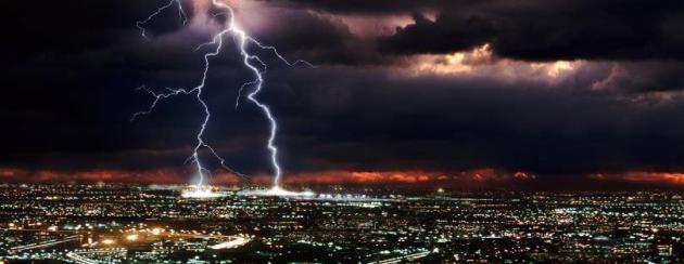
Photo credit above: Corbis. "
Lightning over an unnamed
city. Climate change is a divisive issue, and experts are urging the
IPCC to handle its information strategy differently."
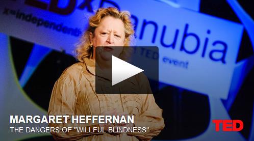
Willfull Blindness. Here's a compelling TED video clip and explanation from (Republican) climate scientist
Barry Bickmore: "...
Now,
I don’t have to tell my readers how I think this story relates to
being a Republican Earth scientist who takes climate change seriously.
But watch the video and pay attention to how Heffernan describes the
excuses people make for remaining willfully blind. See if you don’t
find eerie similarities with the excuses you hear coming from the
“Do-Nothing-About-Climate” crowd..."
On Climate Change, Think For Yourself. Here's an excerpt from an Op-Ed at
The Bangor Daily News: "...
With
the future looming, Americans are divided about whether climate change
is a reality or is a hoax perpetuated by the liberal elites. Virtually
the entire community of climate scientists is in agreement about the
facts. Why then the continuing doubt of so many people? The fossil
fuels industry and all those whose livelihood depends upon the fate of
fossil fuels have a vested interest in maintaining the status quo. They
are the conservatives, whether Democrat, Republican or whatever.
Pollution is, as Al Gore has named it, an “inconvenient truth” for
them, and they deny its existence. Those conservatives are mainly the
rich and powerful. They will squeeze the last drop of fossil fuels out
of the earth as if their lives depended upon it, as indeed it does..."
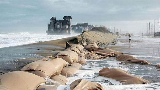
14 U.S. Cities That Could Disappear Over The Next Century, Thanks To Global Warming.
Miami is still at the top of the list, much of South Florida 3-6 feet
above mean sea level. Superimpose rising seas and occasional storm
surges from hurricanes and other major storms and you have a growing
problem, as reported at
Huffington Post: "
There is really no way around it: Thanks to climate change, sea levels are rising.
A huge question on the minds of many is, what does this mean for
America? Will sea walls and city planning protect major metropolises, or
are we bound to lose some national gems? Unfortunately, the latter is a
significant possibility. Read on for 14 U.S. cities that could be
devastated over the next century due to rising tides..." (Photo: Andrew Demp, Yale).
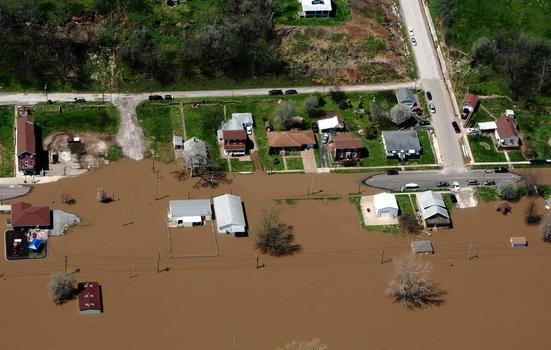
Barge Operators Struggle Along The Mississippi. New
contracts that hedge risk for barge operators facing extremely severe
weather, whiplash back and forth from flood to drought? Here's a clip
from
The Wall Street Journal: "...
For
the first time, privately held Canal Barge Co., which transports
liquid cargoes like machine lubricants up the river from refineries in
the South, has started to add "disruption clauses" to its contracts with
shippers. The new clauses require customers to cover the cost of
delays or other losses caused by high or low water, says Merritt Lane,
president and chief executive. "I'm certainly concerned about the
increasingly unpredictable weather patterns," says Mr. Lane. He says
Canal Barge's profits fell sharply last year because of the drought. The
low water halted river traffic in some places, held up grain shipments
and reduced the loads that barges could carry..."
Photo credit above: "
The Mississippi River overflowing this spring near LaGrange, Mo." Associated Press.


No comments:
Post a Comment