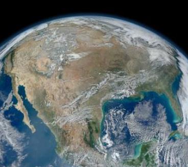
92 F. high in the Twin Cities Wednesday
5th Day of 90s in a row in the metro area.
78 F. average high on August 28.
84 F. high on August 28, 2012.
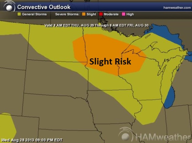
Slight Severe Threat today.
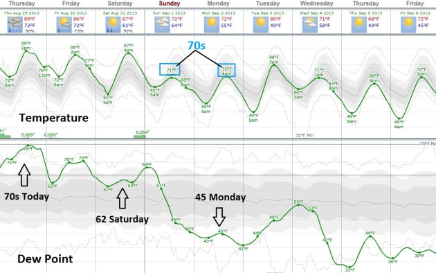
40-degree dew points by Labor Day (half as much water in the air - highs in the 70s)
Sweet Holiday Weekend Relief
Not sure about you but I'm enjoying my
complimentary virtual vacation in Manila. I should be serving towels
with this forecast. Five straight days of 90s and jungle-like dew points
in the 70s is quite enough, thank you.
"But can't you DO something about this weather?"
a teacher asked during a speech yesterday to the Buffalo School
District. Short answer: nope. And even if I could I wouldn't be able to
afford the lawyers. Nudging storms and fronts to cool it off or make it
rain? A sneeze in the breeze - not going to happen anytime soon.
The best chance of T-storms today comes north of
the Twin Cities; precious little rain for parched fields over southern
Minnesota.
The worst of the suffocating heat is behind us
now, but if there's even a glimmer of sun temperatures top 90F into
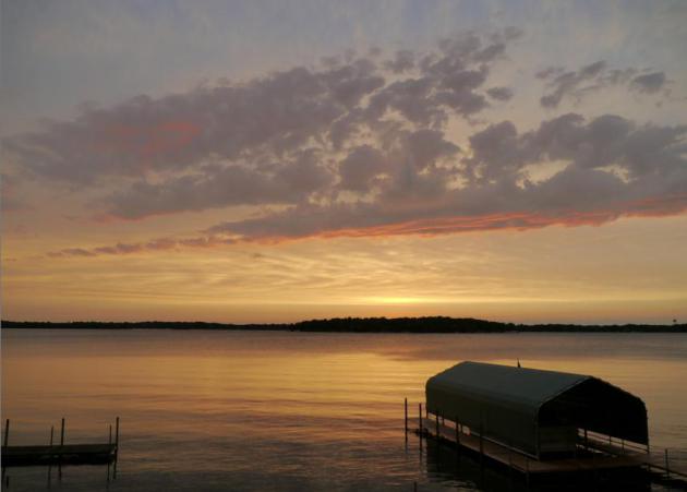
Saturday, the best day to take a dip in your favorite lake.
T-storms late Saturday herald the arrival of
sweet relief; Canadian winds drop dew point into the 40s by Labor Day -
meaning HALF as much water in the air.
Highs hold in the 70s Sunday and Labor Day, as
free A/C pours south of the border. Lows in the 40s late next week?
Remind me to never bad-mouth Canada again.
Thank you Manitoba!
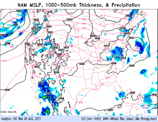
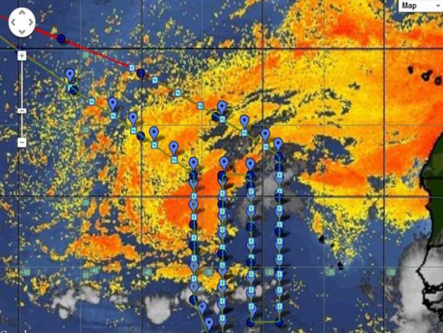
Thursday Severe Risk. SPC has a slight risk of
isolated severe storms today from the Red River Valley to Brainerd, St.
Cloud and the Twin Cities, into a portion of northwest Wisconsin.
Source: NOAA SPC and Ham Weather.
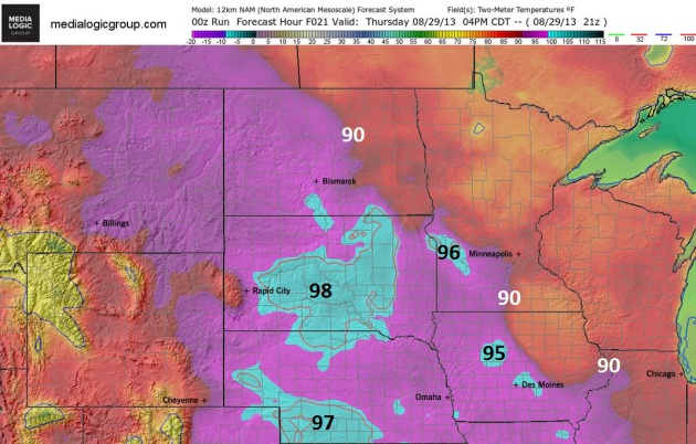
4 PM Thursday. Hot, steamy weather lingers over
southwest Minnesota today; 90-degree highs pushing into the southwest
suburbs of the Twin Cities, but the worst of the heat stretching from
Pierre, South Dakota into southern Nebraska. A weak frontal boundary
over central Minnesota coupled with an upper air disturbance (cold twist
of air aloft) may set the stage for T-storms, a few may be strong to
severe. Source: Ham Weather.
Temperature And Dew Point Trend - Relief In 3 Days.
Here's the ECMWF forecast; sticky heat spilling over into Saturday
before a strong Canadian cool front arrives Saturday night. Dew points
reach the low to mid 70s today, slight relief by Saturday - 40s by Labor
Day. Every 20 degree drop in dew point means HALF as much water in the
air. Next week? Much more comfortable, a taste of true September.
Graphic: Weatherspark.
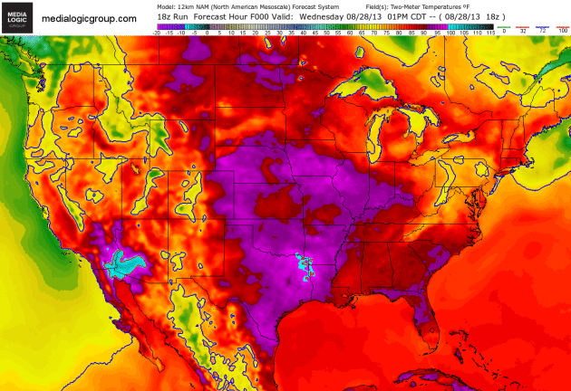
Slowly Shrinking Heat Bubble. The 84 hour NAM model
(2 meter temperatures) shows highs surging well into the 90s over the
Plains and Midwest into Saturday, relatively cool, comfortable weather
over New England. The strongest cool front in 2 weeks will push
southward out of Canada early next week, providing much-needed relief
for the northern tier states. Animation: NOAA NCEP and Ham Weather.
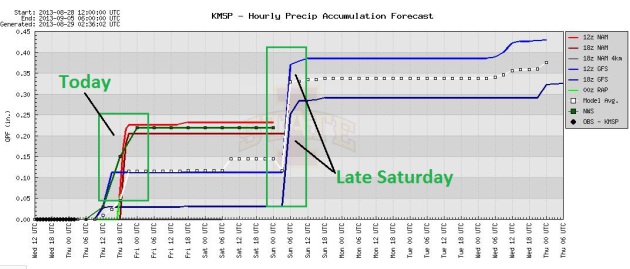
Two Opportunities For Rain. No more "risk of rain"
or "threat of T-storms". It hasn't rained in over 3 weeks, crops, lawns
and gardens are drying out, lake water levels are down - we need rain.
Models show a chance of showers and T-storms today, again late Saturday
out ahead of a significant cool frontal passage. Graphic: Iowa State.
Finally, Hints of Autumn. Good news for hot and
bothered residents of the Midwest and Upper Mississippi River Valley.
Canadian air will push south by Sunday, setting the stage for
comfortable weather next week. The east dries out, a few showers with
higher humidity levels pushing north toward Yosemite, which may help
fire-fighting efforts by Sunday and Monday of next week. 84 hour NAM
forecast: NOAA.
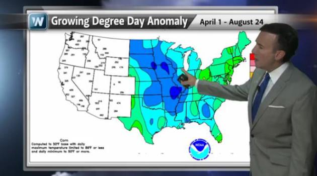 Stressed Crops - Paranoid Farmers
.
Every summer is challenging for farming, between flash floods, hail,
heat spikes and the specter of drought. This summer was especially
challenging, a very late start to spring planting (it was still snowing
in May). Rain fell early in the season, then we had a month of unusually
cool weather, followed by a heat spike (and dire lack of rain
stretching for over 3 weeks). No wonder the corn and bean crop is
showing signs of stress. We take a look at an unusually tough summer for
farming in today's edition of
Climate Matters:
"
WeatherNationTV Chief Meteorologist Paul Douglas looks at some of the
troubles facing framers near the end of the growing season. Snow in May
pushed back planting and a lack of rain has some farmers worried."
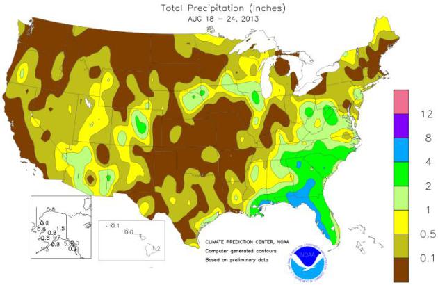
Total Rainfall: August 18-24. Check out how little rain fell over the western two thirds of America and New England last week. Map courtesy of the
USDA.
USDA Crop Report Analysis. It's been quite a roller
coaster ride for farmers in Minnesota and much of the Upper Midwest.
Here's an excerpt of a good summary of where things stand at
cornandsoybeandigest.com: "
There has been a lot of uncertainty in many portions of the major corn and soybean
producing areas of the United States during the 2013 growing season,
which lead to a very highly anticipated Aug. 12 USDA Crop Report. Large
areas of Iowa, Minnesota, Wisconsin and North Dakota were severely
impacted by very late planting, which lead to a significant amount of
prevented planted crop acres. Much of this same region was also
negatively impacted by excessive rainfall in May and June, and is now
dealing with concerns related to slower than normal crop development,
due to very cool temperatures in late July and early August. The USDA
Crop Report issued on Aug. 12 estimated the 2013 total U.S. corn
production to be 13.8 billion bushels, which would be new corn
production record, if realized..."
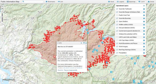
Deep Dive On The Yosemite Wildfire With The Interactive "Rim Fire Perspectives" Map. This is an amazing online tool showing real-time conditions, courtesy of
ESRI and
Time Magazine; here's a clip of the accompanying story: "...
Esri, the company I wrote about on Monday
that specializes in geographical information systems, or GIS, just
released a new version of its wildfire tracking tool that offers several
unique views of the fire, including the specific areas and
infrastructure threatened by the fire, a view that illustrates how the
fire has grown since it started on August 17 and a comparison angle that
shows where fires have burned near Yosemite in the past. As you’ll see
if you start clicking around, each layer offers considerably more
nuance than the basic public information map.
In the default “Critical Points of Interest” view, you can see crucial
locations like the O’Shaughnessy Dam and reservoir, which supplies
water to the San Francisco Bay Area, or the groves of ancient sequoias —
some of the oldest living things on the planet — threatened by the
blaze. If you tab down to the “Fire Progression” view, you can click on
different colored areas of the fire, like layers on a topographical
map, to see pop-ups detailing where the fire’s perimeter was on a given
day, and you can also see which areas the Rim Fire’s most likely to go
next based on “wildfire potential” coloring that reflects areas more
or less likely to burn intensely..."
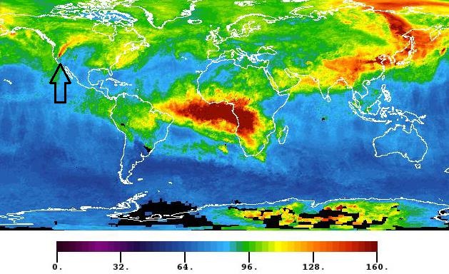
Tracking The Yosemite Fire From Space. You can see a plume of carbon monoxide from the Rim Fire, highlighted in an article at
space.com; here's an excerpt: "...
Another
photo, captured on Aug. 26 by Aqua's Atmospheric Infrared Sounder
(AIRS) instrument shows a plume of carbon monoxide emanating from the California Rim Fire.
The image shows a three-day running average of carbon monoxide at an
altitude of 3.4 miles (5.5 km) above the planet, NASA officials wrote in
a statement."
Image credit above: "
The plume of carbon monoxide
pollution from the Rim Fire burning in and near Yosemite National Park,
Calif., is visible in this Aug. 26, 2013 image from the Atmospheric
Infrared Sounder (AIRS) instrument on NASA’s Aqua spacecraft." Credit: NASA/JPL-Caltech.
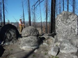
Fire Fighters Stretched Thin, Says Wildfire Expert. Some potentially troubling news - here's a clip from South Dakota State University and
Claims Journal: "All eyes are on the
Rim fire in California,
yet for the fifth time in 10 years, our nation is at Preparedness
Level 5, which means our firefighting capabilities are stretched thin
and the government can opt to bring in the military and even
firefighters from other countries. Professor Mark Cochrane, a senior
scientist at the Geospatial Sciences Center of Excellence at South
Dakota State University, is using satellite imagery to help improve
forest management techniques. One of his projects is designed to
determine which management techniques, including thinning and
prescribed burns, work best in which forests in the United States. The
study focuses on 630 large wildfires that occurred in the last decade
in U.S. National Forests..."
Photo credit above: "
Mark Cochrane, senior scientist at
the Geospatial Sciences Center of Excellence, surveys damage from the
Antelope Complex Fire in Plumas National Forest in northern California.
Sparked by lightning, the 2007 fires were fueled by an abundance of
dead trees and brush on the forest floor."
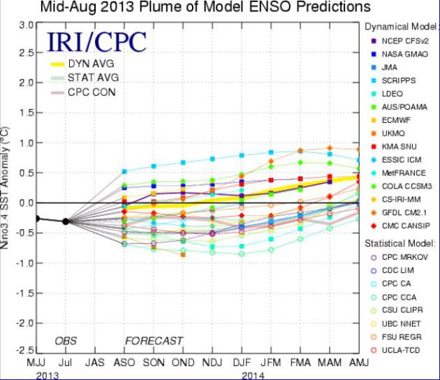
ENSO Neutral Conditions To Linger Into Winter. If anything the official
NOAA NCEP forecast
shows a slight bias toward a (mild) El Nino warming of the equatorial
Pacific Ocean. The threshold is +.5C, and we may come close. The ENSO
forecast details from NOAA are
here.
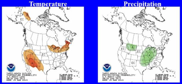
Place Your Bets. Here is the latest Autumn Outlook
from NOAA CPC, showing a slight bias toward milder than average
conditions from eastern Minnesota into New England, better odds of
warmth for the Southwest. Hopefully we'll get some significant moisture
in here between September and November, to recharge soil moisture for
2014.
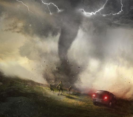
Legendary Tornado Chaser Tim Samaras' Last Ride. Tim
was a legend in the meteorological research community, and he is
missed. His death, along with his son and another researcher was a
reminder of the inherent dangers of "intercepting" tornadoes, which are
fickle and unpredictable by nature. Here's an excerpt from a story at
Miami New Times: "
Before
it came for him, Dan Robinson watched the thing grow. It began as a
bolus that descended out of the storm, projecting needle-like vortices
that lanced the wheat fields near a lone pump jack. Columnar towers a
hundred yards wide gathered and darkened against the pale light to the
south, unspooling into wispy coronas that moved across the prairie
beneath the rotating, two-and-a-half-mile-wide wall cloud above. It was a
little after 6 p.m. on May 31. Dozens of storm chasers were navigating
back roads beneath a swollen, low-hung mesocyclone that had brought an
early dusk to the remote farm country southwest of El Reno, Oklahoma.
Robinson, a website designer and chaser from St. Louis, jumped into his
compact Toyota and sped east. He peered out at the tornado framed in
his passenger-side window, now wrapping itself in rain so dense that he
struggled to make out its leading edge. He swore it was moving farther
away. If he got out ahead of it, he reasoned, he might get a better
look..."
Image credit above: Bastien Lecouffe Deharme.
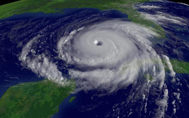
Hurricane Season A Bust? Don't Be So Sure. I suspect
things will heat up in the tropics in September - but then again, the
way the last few years have gone with extreme weather, nothing would
surprise me. Here's a clip from
NPR: "
Back
in May, several independent forecast groups predicted an . But with
August drawing to a close, we've yet to see a single one. Despite being
hurricane-free so far, the National Oceanic and Atmospheric
Administration is that warned of between seven and 11 hurricanes from
the beginning of June to the end of November. But in case you should
think (or hope) that the 2013 hurricane season is a bust, Brian
McNoldy, a senior researcher at the University of Miami's , has done
some potentially sobering math: Writing for The Washington Post's
Capital Weather Gang blog, that while it's somewhat unusual to have no
hurricanes this late in the season, it's by no means unprecedented:
It happened in 1984, 2001 and 2002..." (Hurricane Rita file image courtesy of NOAA/NASA).
Lingering Saharan Dust Eastern Atlantic. Here's a
slightly different perspective, and one significant reason why we are
seeing a temporary lull in Atlantic hurricane formation. The Global Hawk
(drone) was in the air for over 25 hours, sampling the air off the
coast of Africa, which still has considerable dust from the Sahara
Desert, as reported by
NASA: "
The
second science flight of NASA's HS3 mission occurred over the weekend
of Aug. 24 and 25. Global Hawk 872 studied the dry air off the
African coast and dropped 54 dropsondes during a 25.5-hour flight. The
aircraft returned to NASA's Wallops Flight Facility in Va. on Aug. 25.
This graphic shows the pattern of the weekend flight over a satellite
image of the Saharan air layer. Orange shading indicates the
locations of dry, dusty Saharan air."
Babies Learn Words Before Birth. I thought this was an interesting read; here's a portion of a recent article at
Science News: "
Parents-to-be
better watch their language. Babies can hear specific words in the
womb and remember them in the days after birth, a new study reports.
The results add to the understanding of how the early acoustical
environment shapes the developing brain. Earlier studies have found that
fetuses can hear and learn certain sounds. Nursery rhymes, vowel
sounds and mothers’ voices can all influence a developing baby. But the
new study, published August 26 in the Proceedings of the National
Academy of Sciences, shows that a fetus can detect and remember
discrete words, says study coauthor Eino Partanen of the University of
Helsinki. “The fetal learning capabilities are much more specific than
we thought,” he says..."
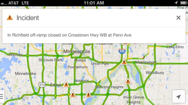
Local TV Facing Increasing Competition In Weather And Traffic.
Lost Remote has the story; here's an excerpt: "
The most popular mapping and navigational tool on the planet, Google Maps, is expanding its traffic coverage. This week the app added
traffic accidents and other incidents courtesy of Waze, the mobile
startup Google acquired for $1 billion earlier this summer. This is
just one more sign that two of local TV’s biggest drivers — weather and
traffic — are under increasing pressure from non-traditional
competitors on the platform that increasingly matters the most: mobile.
Google Maps has an incredible footprint. It’s always in the top
most-downloaded apps on iOS, and it’s pre-installed into most Android
devices. With the addition of Waze data — which is crowdsourced from its
users — Google Maps is now the most popular traffic news source by a
long shot. If you combine both Google properties, it’s a landslide,
especially if you consider Android’s incredible growth curve..."
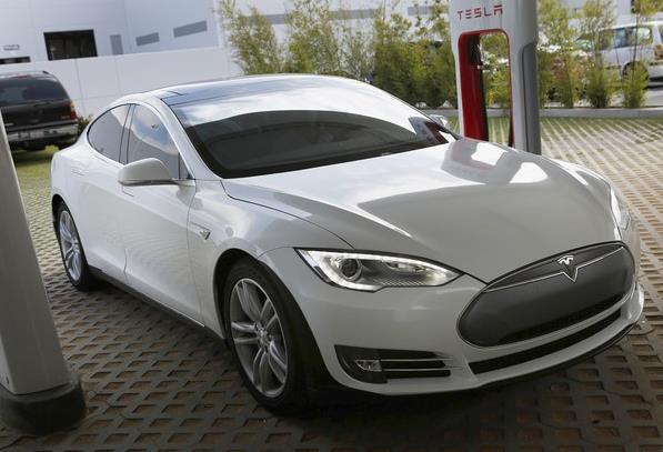
Tesla Quietly Becomes One Of California's Best-Selling Luxury Cars. Here's an excerpt from
The Los Angeles Times: "
Tesla Motors
Model S has quietly become the third-bestselling luxury car in
California, trailing only the Mercedes-Benz E-Class and BMW’s 5-Series.
Tesla has sold 4,714 of its Model S electric cars in the state during
the first half of the year, according to the California New Car Dealers
Assn. Only the Mercedes E-Class, with 6,582, and the BMW 5-Series,
with 6,077, sold more. Moreover, it looks like California accounts for
about 50% of the Palo Alto car company’s total sales during the first
half of this year..."
Photo credit above: "
Tesla has become a top seller among
luxury cars in California with sales in the first half of 2013 trailing
only the Mercedes E-Class and the BMW 5-Series."
(Patrick T. Fallon / Bloomberg / August 27, 2013)
The Amazing And Ridiculous Tech From A 30-Year-Old Sears Catalog. Are you old enough to remember the Sears Catalog? Sadly I am - and I loved this article from
Wired. I was one of those morons who blew $1k on a Sony Betamax. Not one of my better decisions: "
VHS - Beta: $890. Catalog Description:
Sears Best Beta VCR has four-day, eight-program advance
programming, multi-function infrared wireless remote control plus
noise-free special effects and more! Quartz synthesized electronic
tuner. Everyday function lets you program unit to record program at the
same time everyday.
Hindsight is 20/20, according to everyone who's made a huge
mistake. We still feel particularly bad for those who spent nearly
$1,000 on a VCR tied to the losing video cassette format. VHS overtook
Beta and became the compatible VCRs ended up on top of all our TVs.
Sure, Beta was the superior format. But VHS was everywhere by 1983, and
the format helped us record our favorite episodes of The A-Team. That
is, until the DVD showed up and kicked VCRs to the curb..."
Blackberry Is A Failed State. Yes, I too had a Blackberry, and not that long ago. What happened?
Buzzfeed
does a good job explaining how the once-iconic phone-maker was ambushed
by creative destruction (and a sense of hubris that didn't help them
very much). Here's an excerpt: "
BlackBerry, as BlackBerry users know
it, is finished. The company that was almost single-handedly
responsible for the creation of always-on mobile culture but stopped
short of winning the smartphone race is facing some grim options. The
company, now, is a shadow of its former self; soon, it will be lucky if
it’s still recognizable as a company at all. This is a situation in
which hindsight is perfectly unobscured: BlackBerry made an enormous
bet against the style of product that ended up replacing it as most
Americans’ first smartphone. It’s easy to see what happened. But it’s
less clear what happens next. What does collapse mean for a company so
large and culturally significant? Floyd Norris of the Times explains
it in terms of much older computer manufacturer DEC, whose narrative
of market failure traces a trajectory similar to BlackBerry’s..."
Image credit above:
John Gara / BuzzFeed
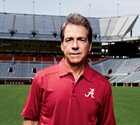
Nick Saban: Sympathy For The Devil. A college
football coach who takes his craft to a new (pathological) level? Saban
is in a universe of his own, captured and memorialized forever in this
eye-popping read from
GQ Magazine; here's a clip: "...
Saban's
pathological drive helps explain why he's both one of the most
successful coaches in American sports and, simultaneously, one of the
most polarizing. He has now won four national championships—one at LSU
and three over the past four years at Alabama, a coaching run unmatched
in college football in more than half a century—and his Crimson Tide
team is a preseason favorite to win it all again this year. In the
insanely competitive SEC, Saban has been a career-wrecker for opposing
coaches: Phillip Fulmer (of Tennessee) and Tommy Tuberville and Gene
Chizik (of Auburn) all lost their jobs after beatdowns by Saban's
squad. His victory over Florida in the 2009 SEC Championship Game left
quarterback Tim Tebow in tears and the Gators' then head coach Urban
Meyer in the hospital, complaining of chest pains. "The thing that
amazes me about him is that he doesn't let up," says retired Florida
State coach Bobby Bowden. "People start winning, they slack off. But he
just keeps jumping on 'complacency, complacency, complacency.' Most
coaches don't think like that..."
TODAY: Sticky and unsettled. Passing T-storm. Dew point: 71. Winds: SE 10. High: 89
THURSDAY NIGHT: Few T-storms, best chance north of MSP. Low: 73
FRIDAY: Partly sunny, best lake day? Dew point: 68. High: 92
SATURDAY: Sunny start, late T-storms. Dew point: 69. Winds: S/SW 8-15. Wake-up: 72. High: near 90
SUNDAY: Sunny & cooler. Dew point: 53. Winds: NW 10-15. Wake-up: 67. High: 76
LABOR DAY: Great fair day. Bright sun. Comfortable! Dew point: 45. Wake-up: 58. High: 73
TUESDAY: Sunny, turning warmer. Wake-up: 55. High: 82
WEDNESDAY: Next cool front. Stray shower? Wake-up: 63. High: 78
Climate Stories...
The Funniest, Yet Most Effective Way To Deal With Politicians Who Ignore Science Facts? Check out the video from
upworthy.com. You might even want to sign the petition.
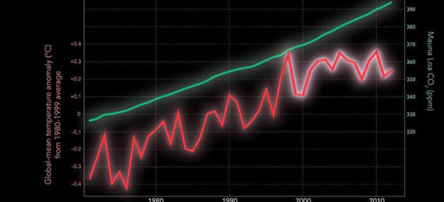
Solving The Mysteries Of Hiatus In Global Warming. A
persistent La Nina cooling phase is a big factor in the
(apparent) surface temperature plateau. Deep oceans continue to warm
worldwide, but this prolonged La NIna phase may be responsible for the
"missing heat". Here's an excerpt of an explanation from the
Scripps Institution of Oceanography: "
New
research by Scripps Institution of Oceanography, UC San Diego climate
scientists attributes the attenuation of a worldwide temperature
increase to a cooling of eastern Pacific Ocean waters, one that
counteracts the warming effect of greenhouse gases. When the climate
cycle that governs that ocean cooling reverses and begins warming
again, the researchers predict that the planet-wide march toward higher
temperatures will resume with vigor. The study does not consider when
the reversal might happen, but it brings scientists closer to
understanding how to look for signs of it. If researchers can estimate
that climate cycle, they could also better estimate the end date of
regional trends that are linked to ocean cooling, such as the drought
in the southern United States that has caused an estimated tens of
billions of dollars in agricultural damage since 2000. Prior to 2000,
global temperatures had risen at a rate of 0.13º C per decade since
1950. The hiatus has transpired while levels of carbon dioxide, the
main greenhouse gas produced by human activities, continued a steady
rise, reaching 400 parts per million for the first time in human
history in May 2013..."
* The new Nature paper from Scripps scientists looking at "Hidden Heat" is
here.
Global Warming Slowdown Linked To Cooler Pacific Waters. Here's another perspective, an excerpt from the
BBC: "...
Prof
Xie said there were two possible reasons why the continuing flow of CO2
has not driven the mercury higher. The first is that water vapour, soot
and other aerosols in the atmosphere have reflected sunlight back into
space and thereby had a cooling effect on the Earth. The second is
natural variability in the climate, especially the impact of cooling
waters in the tropical Pacific ocean. Although it only covers 8.2% of
the planet, the region is sometimes called the engine room of the
world's climate system and atmospheric circulation..."
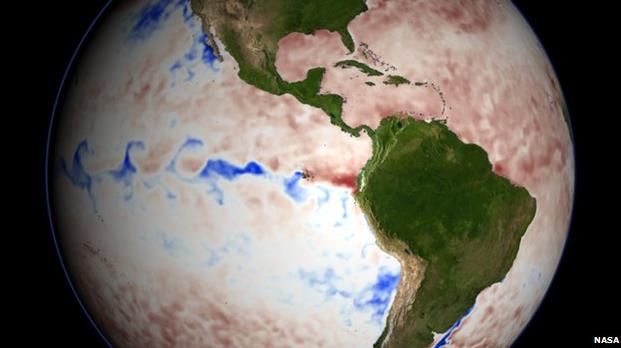
Graphic credit: NASA. "
Cooler waters in the equatorial Pacific are linked to cyclical events such as La Nina."
Is Global Warming Really Slowing Down? Mother Jones
takes a look at the latest meme in the denial community, many of whom
are ignoring deep-ocean warming and what's happening in the Arctic;
here's a clip: "
Chances are you've heard people say that global
warming has "stopped," "paused," or hit a "slowdown." It's a favorite
talking point of political conservatives like Texas Senator Ted Cruz,
who recently declared
that there has been "no recorded warming since 1998." Climate skeptics
frequently use these arguments to cast doubt on climate science and to
downplay the urgency of addressing global warming. Last year, for
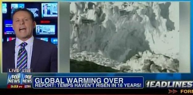
instance, Fox News pronounced global warming "over."
Scientists disagree. It's true that they also acknowledge the slowdown:
A new paper just out in the prestigious journal Nature, for instance,
cites the "hiatus in global warming" and seeks to explain it with
reference to changes in the tropical Pacific. The recently leaked Intergovernmental Panel on Climate Change report,
too, cites an "observed reduction in surface warming." But scientists
say the slowdown is only temporary—a result of naturally induced
climate variability that will soon tip back in the other direction—and
that more human-caused global warming is on the way..."
Graphic credit above: "
Fox News in October 2012." Screenshot: Media Matters/Fox News.
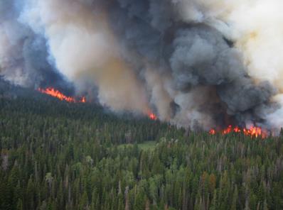
Wildfires Projected To Worsen With Climate Change. Science Codex
takes a look at recent trends, and how a warmer, drier climate in the
western USA will increase the frequency (and size) of future wildfires;
here's a clip: "Research by environmental scientists at the
Harvard School of Engineering and Applied Sciences (SEAS) brings bad
news to the western United States, where firefighters are currently
battling dozens of fires in at least 11 states. The Harvard team's
study suggests wildfire seasons by 2050 will be about three weeks
longer, up to twice as smoky, and will burn a wider area in the western
states. The findings are based on a set of internationally recognized
climate scenarios, decades of historical meteorological data, and
records of past fire activity. The results will be published in the
October 2013 issue of Atmospheric Environment and are available in
advance online. Awareness is building that gradual climate change may
contribute in the coming years to increases in significant, disruptive
events like severe storms and floods. Loretta J. Mickley, a senior
research fellow in atmospheric chemistry at Harvard SEAS and coauthor
of the new study, is thinking one step further, to secondary effects
like forest fires and air quality that rely heavily on meteorological
factors..." (File photo: EPA).
Flying Low Over Greenland, "Icepod" Tracks Changes In The Ice Sheet. The Guardian has the story; here's a clip: "...
The
10-strong team from the Lamont-Doherty Earth Observatory at Columbia
University are testing a suite of airborne radar and imaging systems
known as IcePod, designed to track changes in the Greenland ice sheet.
It would also confirm early signs of instability in the ice. The latest
research into how melting happens has proved more interesting and
complicated than researchers initially thought – not just gusts of warm
air or dramatic spectacles of chunks of ice calving into the sea. It
is now clear that melting has been happening rapidly in some parts of
Greenland, and that meltwater can itself bring about new melting. All
this matters because ice melt in Greenland is the single largest cause
of global sea level rise, which is affecting coastlines around the
world..."
Video link:
Link to video: Scientists track Greenland's melting ice sheets with 'Icepod'
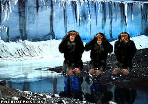
The Era Of Climate Change "Denial" Is Over. Here's an excerpt from a story at
The Guardian: "...
What
we are now seeing more of, though, are climate policy sceptics. Yes,
some of these are the same characters as before, but who have subtly,
artful repositioned themselves over recent years. So rather than
claiming that climate science is a hoax, a fraud or fundamentally
flawed, they now say the proposed climate policies will have little, if
any, impact on the planet's temperature gauge and are therefore a waste
of time and money. They know that this is a more tenable (and
electable?) position from which to argue their point...John Abraham made an astute point
the other day when he said that it rarely gets noticed that climate
sceptics have actually conceded a lot of ground over recent years when
it comes to the science. Many have begun to adopt a so-called
"lukewarmer" position, which means they now accept the basics of climate
science but don't think it's worth investing heavily today to prevent
or limit a problem that will increasingly hit home in the decades ahead..."
People Don't Fear Climate Change Enough. Yes, this
may be the most complex environmental risk we've ever faced as a species
- and human psychology is a big factor. Here's a snippet of an Op-Ed at
Bloomberg: "...
Climate
change lacks other characteristics that spur public concern about
risks. It is gradual rather than sudden. The idea of warmer climates
doesn’t produce anger, revulsion or disgust. Depletion of the ozone layer
was probably the most closely analogous environmental concern; public
attention to that problem was easier to mobilize because of fears of a
huge rise in skin cancer. In this light, it should not be surprising if
people don’t get much exercised by the IPCC’s forthcoming report. All
the obstacles are daunting -- skepticism about the science, economic
self-interest, and the difficulties of designing cost-effective
approaches and obtaining an international agreement. But the world is
unlikely to make much progress on climate change until the barrier of
human psychology is squarely addressed."
Soil Matters. What best practices can farmers adopt
to better weather short-term weather extremes and longer-term stresses
from increasingly violent and damaging cycles of drought and floods.
Here's an excerpt of a post at NRDC, the
National Resources Defense Council: "...
Rather
than incentivizing farmers to adopt risk-mitigating farming practices,
FCIP premiums are set using a formula that ignores how important
healthy, regenerative farming practices -- like conservation tillage,
cover cropping and improved irrigation scheduling -- are to farmers'
risk management as they increasingly face the threats of drought,
floods and other extreme weather events. Methods like no-till farming
not only help soil retain moisture, but also limit erosion, improve
soil health and increase a field's capacity to grow high-yield crops.
Such methods offer farmers short-term protections against each season's
catastrophic weather events, promote fertile fields into the future
and benefit the environment..."
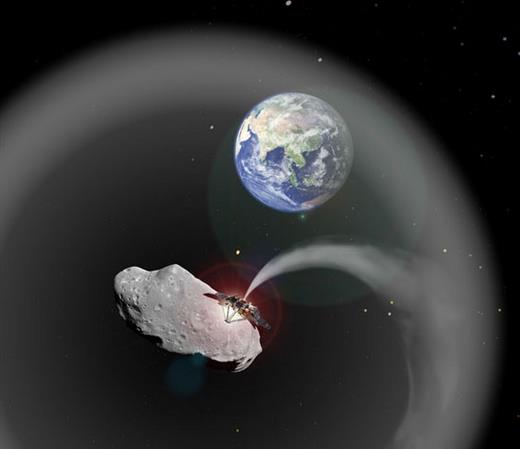
Reacting To Risk: Why Asteroid Threat Is Similar To Long-Term Climate Threat. Here's an excerpt from an interesting post from climate scientist
Mark Boslough: "...
In
the earliest comet and asteroid impact probabilistic risk assessment
papers, back in the early 1990s, scientists recognized that the largest
contribution to the overall threat was from asteroids greater than
about 1.5 km in diameter because they would be expected to cause a
global ecological collapse due to a “nuclear winter” type climate
change. Even though the exact mechanism of global catastrophe was not
(and is still not) completely understood, it was recognized that
climate disruption was the primary cause. I argue that we should apply
the same conventional probabilistic risk assessment methods to
human-caused global warming that we apply to the asteroid threat. The
primary focus should be on reducing the likelihood of global
catastrophe by minimizing human-caused changes to the atmosphere that
damage its ability to maintain a stable climate and habitable planet..." (Image credit:
dvice.com).


No comments:
Post a Comment