By Paul Douglas
When I go to Las Vegas I see a few shows & have a nice meal, but I don't play the slots or blackjack. No, I gamble with start-up companies. I have no desire to do it for fun.
Farmers are some of the best forecasters around. It's a matter of survival. Every growing season they play a reluctant game of craps, throwing their dice, praying a summer's worth of effort isn't destroyed by a single 30 minute hailstorm, hoping their crop doesn't wither in a sudden drought, or wash away in a flash flood. Most buy crop insurance, which is expensive, but in an era of wild extremes and weather whiplash, essential.
55 percent of Minnesota is back in moderate drought, up from 10 percent a week ago.
T-storms mushroom to life later today, a few severe, but we won't see the volume or duration of rain required to dent the drought.
Today may be the 7th day of 90F heat during the State Fair (a new record?), but big changes are brewing. Highs hold in the 70s Sunday & Labor Day, when dew points dip into the 40s. Every 20-degree drop in dew point means HALF as much water overhead. Sweet relief.
Enjoy the break from the muggies; long range guidance shows another spasm of 90F heat next weekend.
______________________________________________________________________________
Todd Nelson's Conservation MN Outlook for the Twin Cities and all of Minnesota
SATURDAY: AM and midday sun, late PM T-storm possible (some possibly severe). Dew point: 64. High: 90. Winds: South 10.
SATURDAY NIGHT: Thunderstorms rumble through, clearing later. Low: 69
SUNDAY: Sunny, windy, cooler. Dew point: 57 Winds: NW 20+. High: 75
LABOR DAY: Best Fair day? Cool, comfortable blue sky. Winds: NE 5-10. Wake-up: 56. High: 73
TUESDAY: Cool start. Sunny and warmer. Dew point: 50. Wake-up: 48. High: near 80
WEDNESDAY: More clouds, stray thunderstorm. DP: 58. Wake-up: 65. High: 85
THURSDAY: Plenty of sun, comfortable. Wake-up: 59. High: 79.
FRIDAY: Sunny, turning warmer again. Wake-up: 52. High; 85
_________________________________________________________________________
More on the Hill City, MN Tornado
Things have certainly been very active across the Midwest lately, more so along the international border. Thanks to a BIG bubble of hot and humid air, thunderstorm activity has been developing on its outer periphery. Much of the work week highlighted thunderstorms and heavy rain across central and northern Minnesota, some of which was severe. There was even a tornado on Thursday evening near Hill City, MN, which was caught by storm chaser Bob Conzemius
Thanks to Bob Conzemius for the information below:
"Caught this one very close to home. I was really surprised what happened today, but in retrospect, it certainly makes sense. Everything had to come together just right."
See more of Bob's storm chase HERE:
See the video of Bob's storm chase HERE:
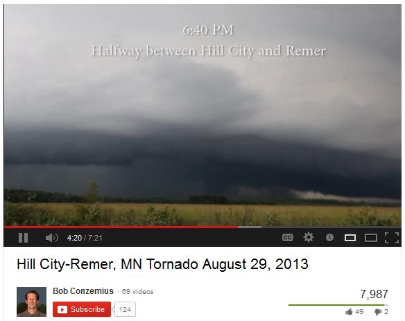
Hill City, MN Tornado
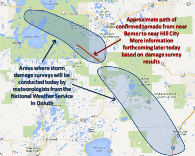
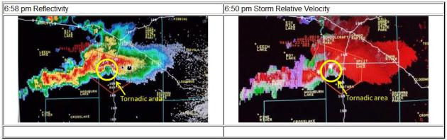
Thanks to the National Weather Service out of Duluth, MN for the information below:
"A tornado touched down west of Hill City early evening on Thursday, August 29th. A skywarn spotter reported the tornado at 6:33 pm two miles east of Remer. The tornado then moved southeast. The Aitkin County sheriff's department reported that numerous trees have been blown down in the area and roads were blocked."
See more from the NWS Duluth HERE:
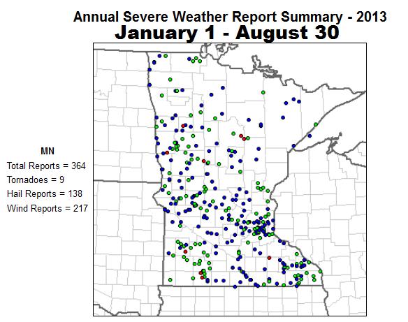
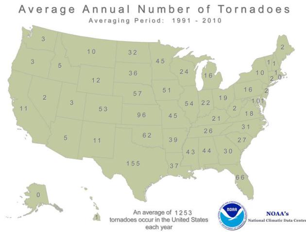
A Lack of Minnesota Tornadoes
It certainly has been a very
quiet year when it comes to severe weather and tornadoes. According to
NOAA's SPC, there have only been 9 PRELIMINARY tornado reports so far
through August 30th. According to NOAA's NCDC, Minnesota typically sees
around 45 tornadoes per year!
Average U.S. Tornadoes by State
Here's a look at NOAA's average U.S. tornadoes by state. Note that the U.S. average annual (according to 1991-2010 data).
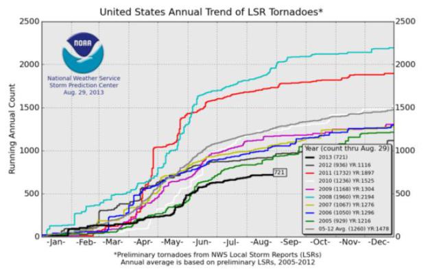
Quiet 2013 Tornado Season
Here's how quiet it has been! According to NOAA's SPC, there have only been 721 PRELIMINARY tornado reports across the country from January 1st to August 29th. The short term average (2005-2012) is 1260 through that date. Interestingly, this is the quietest tornado year so far, within the 2005-2013 time period! Last year at this time, we had seen 1,114 and in 2011 there were nearly 1,900 through August 29th.
See more from the SPC HERE:
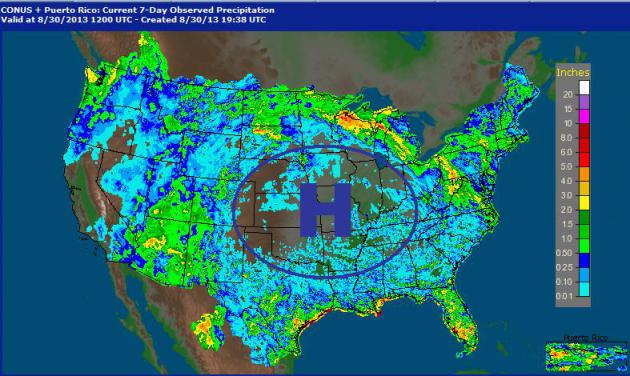
Classic Summer Pattern
Have you ever heard of the
term "Ring of Fire"? It is a pretty classic pattern in the middle part
of the summer when extremely warm air sets up. Thunderstorms tend to
develop along the outer periphery of that big hot dome of high pressure
in an arc-like fasion. The traditional radar shows up in orange and red
when thunderstorms and heavy rain develop, so when this type of pattern
sets up, you tend to get an arc-like shape of orange and red, which ends
up looking like a "Ring of Fire". It's pretty easy to see where this
activity was located when you look at the 7 day radar estimated rainfall
map from NOAA. Note the void of precipitation accumulation in the
central part of the country!
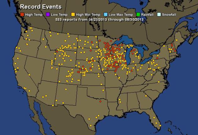
Record Late August Heat
Hot enough for ya? According
hamweather.com, there were 533 record high temps and record low maximum
temperatures either tied or broken with the last 7 days!
Relief in Sight!
For the first time in a long time, there's an actual cool front in the forecast! Take a look at the extended forecast into Labor Day Monday. It'll still be a bit warm and humid on Saturday, but by late weekend and early next week, big changes will be taking place!
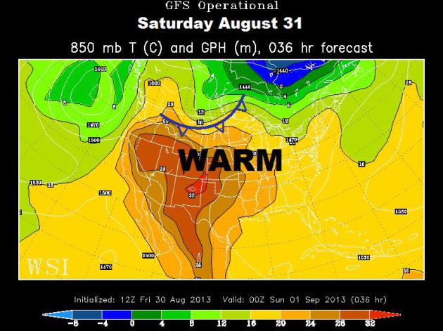
Saturday, August 31st
A cool front begins moving into the Upper Midwest with scattered showers and thunderstorms expected by late day, some of which could be strong to severe.
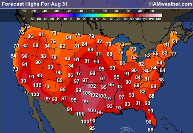
High Temps Saturday
Severe Threat Saturday
As the cold front plows out of
Canada on Saturday, strong to severe thunderstorms could break out along
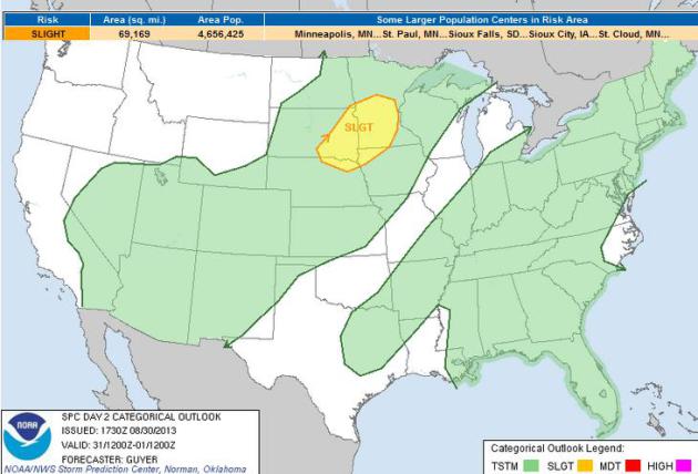
it's leading edge. The Storm Prediction Center has issued a SLIGHT RISK
of severe weather for parts of the Midwest.
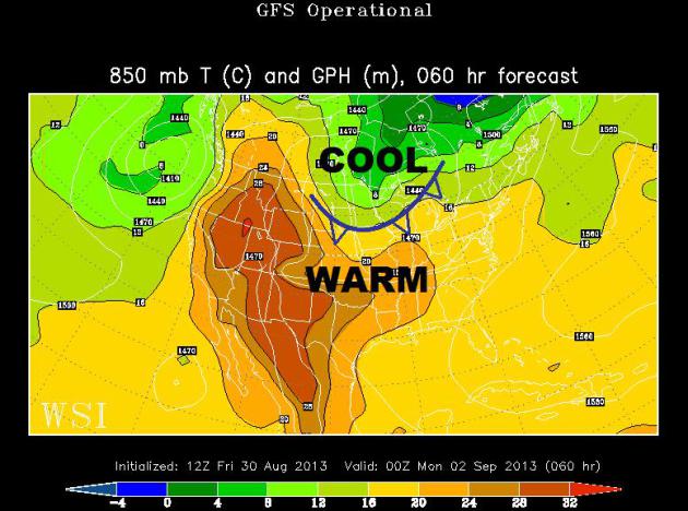
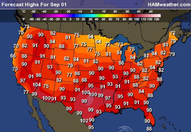
Sunday, September 1st
The front is expected to be
moving into the Great Lakes region by the first day of Meteorological
Fall. By then, there will be many across the Upper Mississippi Valley
feeling more fall-like temperatures!
High Temps Sunday, September 1st
After spending several days in
the 80s and 90s this week across the far north, we could actually see
spots struggling to get to 60F by Sunday across the international border
in the Upper Midwest!
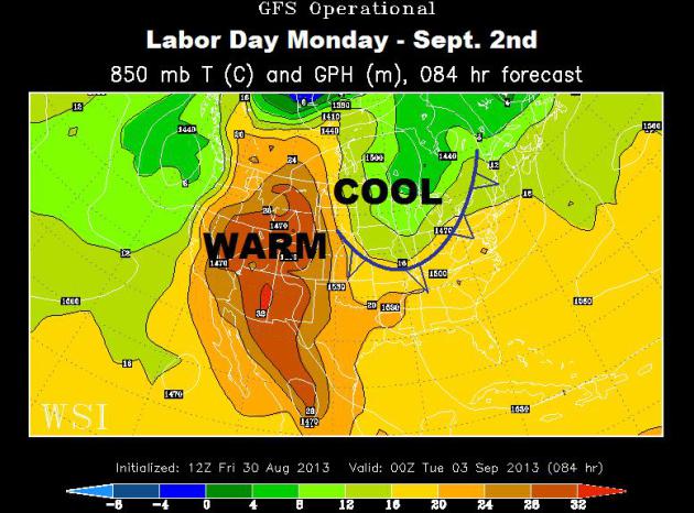
Labor Day Monday
The cool front responsible for
the break in the heat and humidity will have pushed all the way into the
Ohio Valley/Northeast by Labor Day Monday. Scattered showers and storms
are also expected to continue sliding east along with the front.
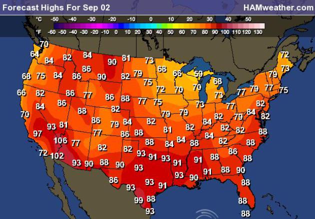
High Temps Monday
Note that by Labor Day Monday, there will be several locations in the Midwest and Great Lakes region in the 70s or colder!
Thanks for checking in and have a great LONG weekend ahead!
Don't forget to follow me on Twitter @TNelsonWNTV

No comments:
Post a Comment