82 F. high in the Twin Cities Thursday.
76 F. average high on September 5.
84 F. high on September 5, 2012.
90 F plus highs likely today, possible Saturday, again next Monday.
Severe drought now reported across central Minnesota.
 Summer Redux
"We know that in September we will wander through the warm winds of
summer's wreckage. We will welcome summer's ghost" wrote Henry Rollins.
The ghost of hot fronts, drippy dew points and scorching heat indices
will be on full display into
Saturday; highs flirt with 90F both days. Not quite as oppressive as last week, but sticky enough to get your full attention.
Severe drought has returned to portions of central Minnesota. The
Twin Cities are in a moderate drought, along with 53 percent of
Minnesota. Nearly 80 percent of the state is "abnormally dry". It feels
like 2012.
Deja vu, all over again.
I'll be surprised if our "flash drought" lasts as long - or becomes
as severe as late 2012 and early 2013. Weather models show a good
chance of T-storms
Monday, another surge of rain by next
Wednesday as cooler air approaches.
The well-dressed Minnesota will walk around in a sweatshirt and
shorts: a cool break next week gives way to more 80s the following
weekend. From 33F at Embarrass
Thursday morning to 90F the next two afternoons; Mother Nature is suffering an identity crisis.
Summer or autumn? With any luck a slow transition to cooler weather will spark more substantial rains.
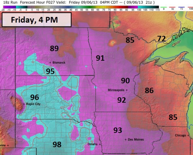
Sizzling Friday. Highs should top 90F today across
the Twin Cities metro and St. Cloud, even some mid-90s for the Minnesota
River Valley. Highs hold in the 70s near Grand Marais, just about the
only comfortable spot in the state. 4 pm NAM temperatures courtesy of
Ham Weather.
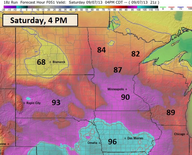
4 PM Saturday. A wind shift to the northeast will
start to cool off northern Minnesota by Saturday afternoon, but highs
may still flirt with 90F south of St. Cloud into the Twin Cities and
Mankato.
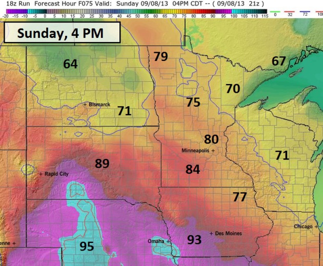
Cooling Off Sunday. The map above (Ham Weather)
shows predicted temperatures at 4 PM Sunday; highs holding in the 70s
north/west of the Twin Cities, the core of the heat pushed south of
Minnesota. Some of that heat and humidity will surge northward again on
Monday.
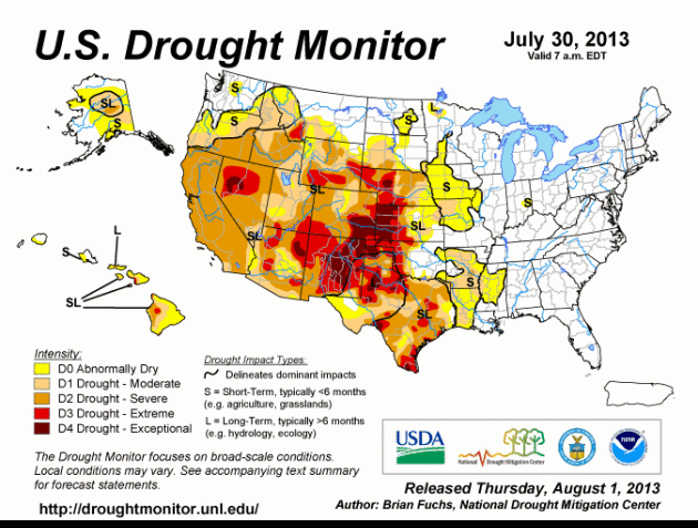
Severe Drought Returns To Central Minnesota. The latest
U.S. Drought Monitor
shows 53% of Minnesota in a moderate drought, 4% in severe drought,
centered on the St. Cloud area, Willmar and Hutchinson. The speed at
which drought is returning and deepening is troubling - only 2 weeks ago
10% of Minnesota was in a moderate drought. Nearly 80% of the state is
described as "abnormally dry".
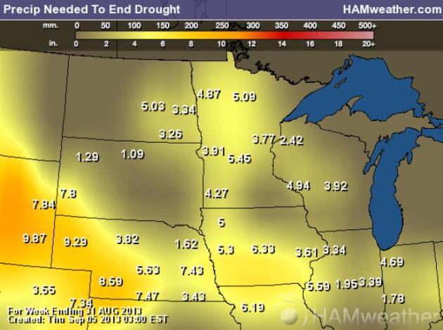
Rainfall Needed To End Drought. Much of Minnesota
needs 3-6" of rain to eliminate the deepening drought. Possible, but not
likely anytime soon. Long-range guidance is hinting at a wetter pattern
next week into the third week of September. Rain may come too late to
help with this year's crop, but a couple of soakings would be very
welcome, recharging soil moisture heading into the winter months. Map:
Ham Weather.
September 2013 "Hydroclim" Update. Here are highlights of a
statewide summary from Minnesota State Climatologist Greg Spoden:
- August rainfall totals were below historical averages in most
MInnesota counties. In many communities, especially in east central
Minnesota counties, August precipitation totals fell short of long-term
averages by two or more inches.
- Across much of the southern three-quarters of Minnesota,
July-plus-August rainfall totals were 4-6" below normal. Rainfall
deficits, along with very hot late-August temperatures, led to a rapidly
developing drought situation across much of the Midwest.
- The U.S. Drought Monitor places an area of central MInnesota in the
"Severe Drought" category. Large sections of the rest of MInnesota are
rated n the "Moderate Drought" category.
- Ample autumn rains will be required to refill the soil moisture profile and to recharge groundwater and surface water systems.
Flash Drought. Summer came late this year to much of
the northern USA. June was abnormally wet, followed by a heat spike the
first half of July, then came unusually cool weather from late July
into the first half of August, a stubborn northwest wind flow aloft
keeping showers and T-storms away from the Upper Midwest. And then came
the heat; the hottest week of summer arrived during the last week of
August, but T-storms tracked over northern Minnesota - no help to farms,
gardens and lawns over central and southern Minnesota. In this 6-week
animation from the U.S. Drought Monitor you can see the rate at which
drought has returned to the Upper Midwest.
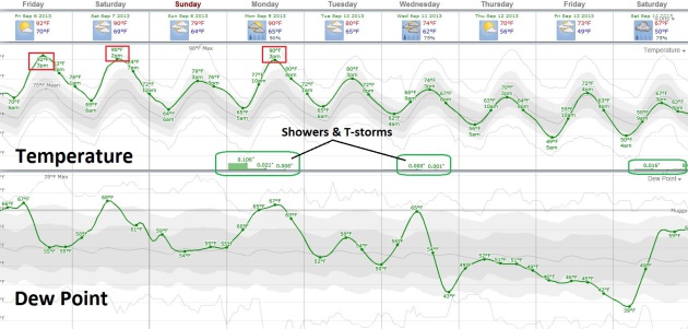
3 More Days At/Above 90F? ECMWF guidance, courtesy
of Weatherspark, shows highs in the low 90s today, near 90F Saturday,
again Monday, before more significant relief arrives next week with a
series of cool frontal passages. Dew points reach the 60s, not as
oppressive as the 70s we endured last week, but sticky enough for most.
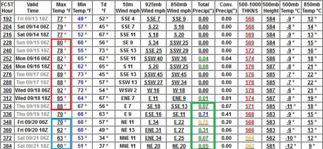
More Warm Fronts. GFS guidance shows highs in the
80s, even a few low 90s during the third week of September, followed by
cooling after September 20 or so. Models are also showing a better
chance of more significant rain during this transition from hot to
comfortably cool - I hope the models are right.
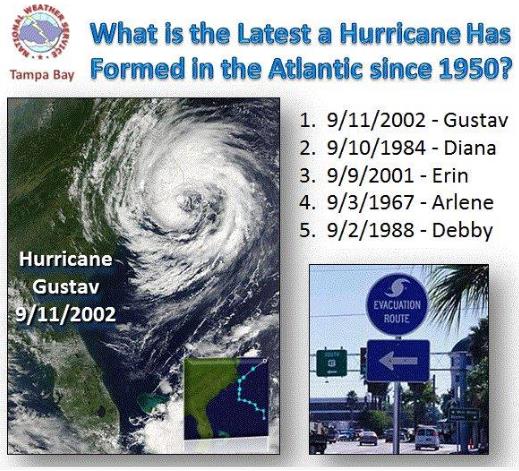
Latest First Hurricane On Record? Will we go another
5 days without a hurricane in the Atlantic basin? If so we'd set a new
record. The latest (first) Atlantic hurricane on record, to date, is
Gustav, back on September 11, 2002. Graphic courtesy of
Tri-State Weather.
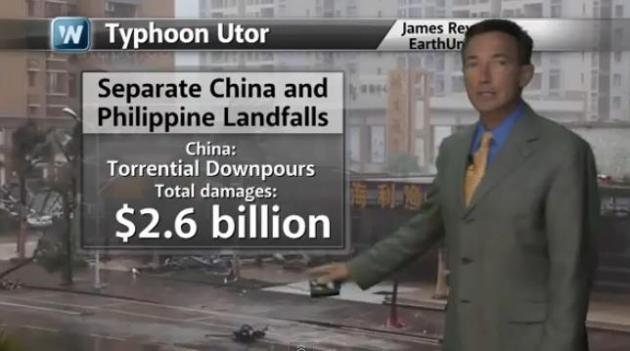
The Global Cost Of Severe Weather. In today's
Climate Matters
I take a look at the latest U.S. Drought Monitor, as well as severe
flooding around the world in August, and a tough winter for portions of
South America: "
WeatherNationTV Chief Meteorologist Paul Douglas
goes over the cost of severe weather. Billion dollar flooding disasters
were seen in China, Russia, the Philippines, and Pakistan. Extreme
winter conditions South America as well as severe weather damaged crops
in the US."
Aon Benfield: August Brings Multiple Billion Dollar Floods Worldwide. Here's an excerpt from a press release at
The Wall Street Journal: "...
The
report reveals that billion-dollar flood losses were recorded in
China, Russia, Philippines, and Pakistan during August, causing an
initial combined estimate of USD10 billion in economic losses.
Persistent rainfall caused flooding across much of China during the
month of August, with Heilongjiang Province sustaining much of the
damage. According to available data from the Ministry of Civil Affairs
(MCA), nationwide totals during August showed that more than 260 people
died, at least 306,000 homes and structures were damaged, and the
aggregate economic loss was at least CNY32 billion (USD5.3 billion).
Across China's northeast border, torrential rains led to the worst
flooding in at least 120 years in Russia's Far East. The Ministry of
Emergency Situations reported that a combined 6,964 homes and 3,762
summer cottages were damaged. More than 627,000 hectares (1.55 million
acres) of agricultural land was also submerged. Total economic losses
were estimated by the government at RUB30 billion (USD1.0 billion)..."
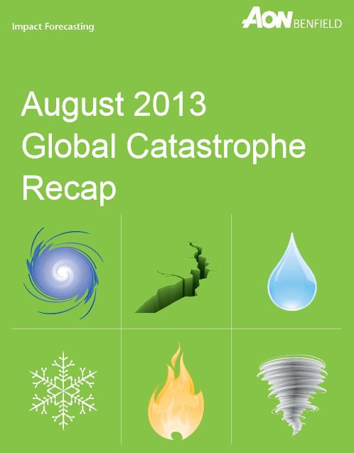
* the August 2013 Global Catastrophe Recap PDF from Aon Benfield is
here.
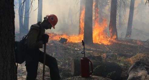
U.S. Says Hunter's Illegal Fire Started Big Wildfire.
Talk about unintended consequences - California's 4th largest fire on
record was (apparently) started by a campfire that went out of control.
Details from
Voice of America: "
U.S.
authorities said that a large wildfire that has consumed vast forests
in one of the country's best known national parks was caused by a
hunter who lost control of an illegal campfire. The country's Forest
Service said Thursday that no arrest has been made in the case and
withheld the name of the hunter. Officials said there was no indication
the hunter was cultivating an illegal marijuana crop, as one local
fire chief had suggested..."
Photo credit above: "
A Hotshot fire crew member rests near
a controlled burn operation at Horseshoe Meadows, as crews continue to
fight the Rim Fire near Yosemite National Park in California, Sept. 4,
2013." (U.S. Forest Service, Mike McMillan).

TODAY: Summer rerun. Sunny and hot. Dew point: 64. Winds: South 15. High: 92
FRIDAY NIGHT: Warm and sultry. Low: 71
SATURDAY: Hot sticky sun. Dew point: 63 Winds: NE 5-10. High: near 90
SUNDAY: Mix of clouds & sun, cooler. Dew point: 50. Wake-up: 67. High: near 80
MONDAY: Tropical. T-storms possible, best chance north of MSP. Dew point: 65. Wake-up: 64. High: 89
TUESDAY: Clearing, less humid. Dew point: 56. Wake-up: 67. High: 81
WEDNESDAY: Chance of rain, T-storms. Wake-up: 63. High: 75
THURSDAY: Partly sunny & comfortably cool. Dew point: 47. Wake-up: 56. High: 73
* sunset photo above (Pelican Lake) courtesy of Heidi Rusch.
Climate Stories...
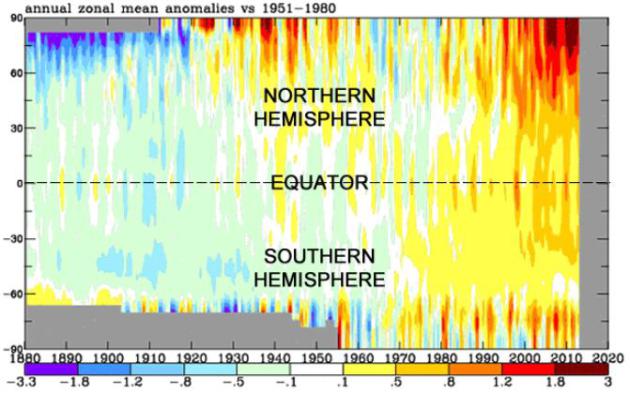
Global Warming In One Unmistakably Compelling Chart. Here's an excerpt from a story by meteorologist Jason Samenow at The Washington Post's
Capital Weather Gang: "
Produced
by NASA, the chart illustrates how temperatures have compared to
“normal” (or the 1951-1980 average) from 1880 to present, from pole to
pole (-90 latitude to 90 latitude). From the 1880 to the 1920s, blue and
green shades dominate the chart, signaling cooler than normal
temperatures in that era. Then, from the 1930s to the 1970s, warmer
yellow, oranges, and reds shades ooze in, balancing the cooler shades.
But since the 1970s, the blue and green shades rapidly erode and oranges
and reds take over, dramatically. The rapid warming at the northern
high latitudes especially jumps out in recent decades, reflecting
“Arctic amplification” or more intense warming in the Arctic..." (Graphic above: NASA).
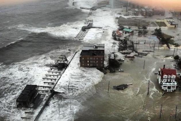
NOAA: Warming-Driven Sea Level Rise To Make Sandy-Type Storm Surges The Norm On East Coast. Here's an excerpt of a story at
Think Progress: "
A
new study by NOAA researchers finds future Hurricane Sandy level
inundation will become commonplace in the future under business-as-usual
sea level rise projections. NOAA’s news release for the report “Explaining Extreme Events of 2012 from a Climate Perspective” summarizes the key finding:
The record-setting impacts of Sandy were largely attributable to
the massive storm surge and resulting inundation from the
onshore-directed storm path coincident with high tide. However, climate-change
related increases in sea level have nearly doubled today’s annual
probability of a Sandy-level flood recurrence as compared to 1950.
Ongoing natural and human-induced forcing of sea level ensures that
Sandy-level inundation events will occur more frequently in the future
from storms with less intensity and lower storm surge than Sandy..."
*
Climate Central has more on the doubling risk of Sandy-scope storm surges.
This September Ask A NASA Climate Scientist. Good for NASA, being more proactive and soliciting questions. Here's more information on the
NASA initiative and a video clip explaining the program: "
The
topic of climate change inspires a lot of debate. At NASA, it has also
inspired a lot of science. NASA scientists examine the Earth's climate
and how it is changing – gaining knowledge through decades of satellite
observations, powerful computer models and expert scientific analysis.
Over the course of this month, these NASA climate experts will answer
selected questions through the agency's social media channels –
primarily on YouTube, Twitter and Google+. But first – we need your
questions. Have a question that's always confounded you about Earth's
climate? Wonder why it matters that the climate is changing now if it
has changed before? Or how scientists know changes seen in recent
decades are the result of human activities, not natural causes?..."
Climate Change Is Cleaving The GOP In Two. Is there a
theoretical revenue-neutral tax on carbon that conservatives might
eventually accept, if not embrace? Here's a clip from a story at The
Tyee and
Salon: "...
A
price on America’s carbon emissions will surely remain theoretical for
some time. No Republican in Congress publicly supports it. Nor does
President Barack Obama. “We would never propose a carbon tax,” the White
House has promised.
Yet the Globe Theatre debate may signal emerging Republican fissures
on global warming. “There is a divide within the party,” one
conservative scholar recently told the National Journal. “The position that climate change is a hoax is untenable...”
Photo credit above:
AP/Ian Joughin.
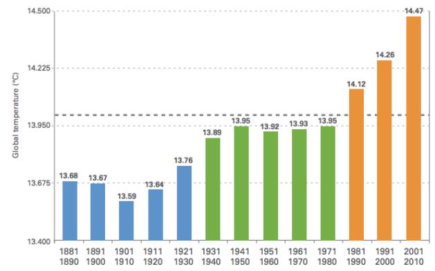
Study Proves That Politics And Math Are Incompatible. Really? Salon sums up the challenge of separating out ideology from science and math in this piece - here's an excerpt: "It’s hard to look at climate change deniers as being anything other than willfully ignorant. The numbers are right there:
As surely as greenhouse gas emissions are rising, so are global
temperatures. To discount all that is to choose to be stupid. But
according to Yale law professor Dan Kahan, it’s easier than we think
for reasonable people to trick themselves into reaching unreasonable
conclusions. Kahan and his team found that, when it comes to
controversial issues, people’s ability to do math is impacted by their
political beliefs..."
Graphic credit:
"Global temperature by decade." (Credit: World Meteorological Association)
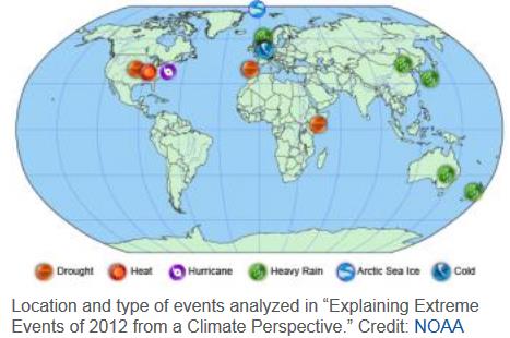
Explaining Extreme Events Of 2012. Here's an excerpt from a summary report by
NOAA NCDC: "...The
report shows that the effects of natural weather and climate
fluctuations played a key role in the intensity and evolution of many of
the 2012 extreme events. However, in several events, the analyses
revealed compelling evidence that human-caused climate change was a
secondary factor contributing to the extreme event. “This report adds to
a growing ability of climate science to untangle the complexities of
understanding natural and human-induced factors contributing to specific
extreme weather and climate events,” said Thomas R. Karl, LHD,
director of NCDC. “Nonetheless, determining the causes of extreme
events remains challenging.” In addition to investigating the causes of
these extreme events, the multiple analyses of four of the events—the
warm temperatures in the United States, the record-low levels of Arctic
sea ice, and the heavy rain in both northern Europe and eastern
Australia—allowed the scientists to compare and contrast the strengths
and weaknesses of their various methods of analysis. Despite their
different strategies, there was considerable agreement between the
assessments of the same events.
* the full report, all 104 pages (PDF) of the report referenced above is
here, courtesy of the AMS, the American Meteorological Society.
Climate Change Reframed: China, World Bank Prioritize Pollution.
Is it merely a matter of semantics? "Let's call it pollution vs.
greenhouse gases and then people will start to take this more
seriously?" We'll see - but I have my doubts. Here's a clip from
SustainableBusiness.com: "
It
seems there's a new way of framing climate change that could work
better in getting significant action: calling it "pollution" rather than
global warming or greenhouse gases. While people can't sense the
presence of carbon, they directly experience pollution, and especially
in China, they are fired up about it. "Public concern about air
pollution has helped raise awareness about broader environmental
problems," Jiang Kejun, an energy advisor to the Chinese government, told the New York Times. "This will be a big help in pushing China" [on cutting climate-related emissions]..."
More Fracking Headaches As Earthquake Evidence Grows.
Clean Technica has the story - here's an excerpt: "
It
looks like more trouble is looming ahead for communities that host
fracking operations. Two new studies have linked fracking-related
operations to earthquakes in Texas and Ohio, and a recently settled
lawsuit in Arkansas indicates that swarms of tiny earthquakes can damage
surface structures. Add earthquakes to a list that already includes
water contamination and air pollution risks, and it becomes clear that a
more effective regulatory platform is needed to protect existing
communities from the impacts of fracking..."
File Photo above: Martin Luff.


No comments:
Post a Comment