By Todd Nelson
I am happy to report that there is actual rain in the extended forecast!
2013 has been an interesting year with heavy snow late into the Spring season and fall-like temps during what was supposed to be the hottest time of the year. Interestingly, we are still nearly 3" above normal precipitation since January 1st, but we are about 3" below normal precipitation since June 1st.
Lawns and gardens have been having a tough time lately and local trees and bushes are starting to show signs of stress. The hint of fall color appearing in neighborhoods near you isn't so much due to the recent cool down as much as it is due to the lack of moisture.
According to the U.S. Drought Monitor, the Midwest has gone from nearly no drought to 30% moderate drought and 11% severe drought in just 2 months. Likewise, Minnesota has jumped to 55% moderate drought and nearly 8% severe drought, which includes parts of the Metro.
The good news is that there are several rain chances over the next 7 days, the first of which moves in later today with the heaviest rains (up to 0.50" or more) falling in central and southern Minnesota. Cross your fingers!
_____________________________________________________________________________
Todd's Conservation MN Weather Outlook for the Twin Cities and all of Minnesota
SATURDAY: Sunny start, clouds increase late. Spotty shower or storm possible later. High: 70. Winds SW 10-15
SATURDAY NIGHT: Chance of showers/storms continue. Low: 55
SUNDAY: Soggy start. Decreasing clouds, cool breeze. High: 68
MONDAY: Chilly start. Lots of sun. Perfect Wake-up: 46. High: 68
TUESDAY: Clouds thicken through the day. Spotty PM shower or storm possible. Wake-up: 54. High: 72
WEDNESDAY: Warmer and more humid. Unsettled with a few showers/storms. Wake-up: 61. High: 81
THURSDAY: Lingering shower or storm possible. Wake-up: 64. High: 80.
FRIDAY: Cooler with a stray PM shower. Wake-up: 59. High: 74
_____________________________________________________________________________
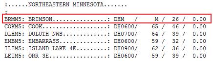
Chilly Start on Friday
Friday morning was quite chilly for folks in Northeastern Minnesota. Several locations posted 32F as their low temperature, but a Cooperative Weather Observation Site in Brimson reported a low of 26F! YIKES!!
See more low temps from NE Minnesota HERE:
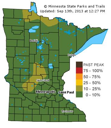
Fall Color Update
Some folks may think it's a bit too early to break this map out, but in fact, there is a bit of color showing up in neighborhoods near you. According to the Minnesota DNR, there are a couple of pockets of 10%-25% color. Again, some of this may be due to the lack of moisture, but there certainly have been some chilly nights across northern Minnesota that may be helping the color there. Keep in mind that far northern Minnesota typically sees peak color by late September/early October.
See more from the MN DNR HERE:
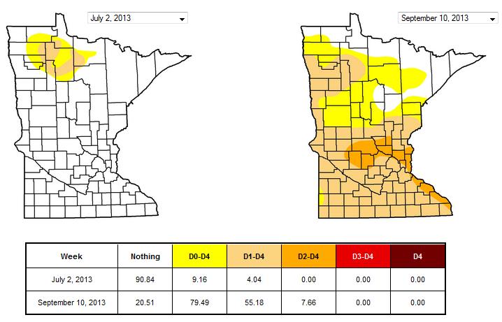
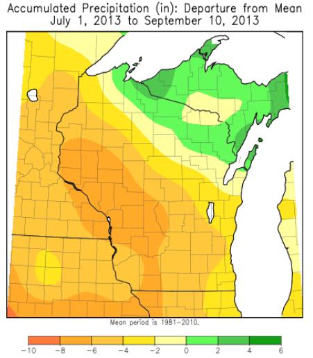
Minnesota Drought
According to the U.S. Drought monitor, nearly 80% of the state is considered to be abornormally dry, 55% in a moderate drought and nearly 8% in a severe drought. Compare that to only 9% abornormally dry, 4% moderate drought and no severe drought just 2 months ago. The lack of rain really is showing in local lawns and gardens.
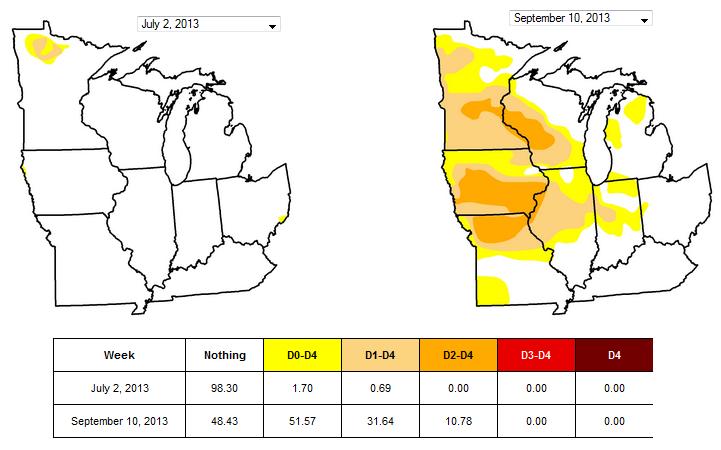
Midwest Drought
Take a look at how much drought conditions have expanded across the Midwest over the past 2 months! We've literally gone from nearly no drought to a wide area of very dry conditions. Let's hope it doesn't continue...
See more from the U.S Drought Monitor who will be coming out with a new version of their website soon, check it out HERE:
Flash Drought
Here's more on the Flash Drought from the National Weather Service out of La Crosse, WI.
"During the past month, a flash drought (a rapidly developing drought) developed across much of western Wisconsin, southeast Minnesota, and parts of northeast Iowa. In the September 10th U.S. Drought Monitor, severe drought (D2) has recently developed in all or parts of Houston, Wabasha, and Winona counties in southeast Minnesota"
See more HERE:
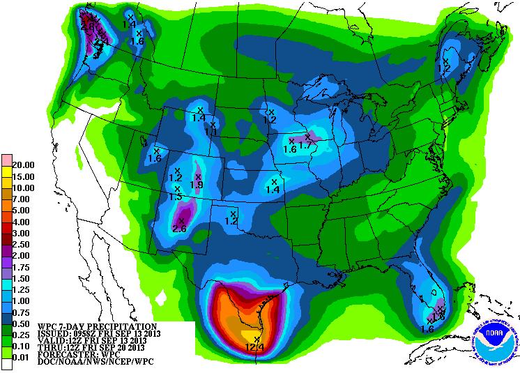
Good News
The good news is that there apperas to be several precipitation chances in the Midwest, which will help a bit. According to NOAA's HPC 7 day rainfall forecast, some could see up to 1" or more through the end of next week. Note the big blob of moisture across southern Texas! Thanks to a newly devloped storm in the Gulf of Mexico/Bay of Campeche (Ingrid), waves of moisture will lift into northeastern Mexico and southern Texas over the next several days, which may lead to flooding.
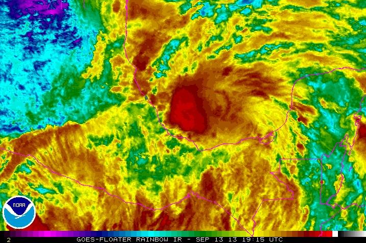
Tracking Ingrid
The National Hurricane Center started issuing advisories for Ingrid on Friday, which is our newest storm in the Bay of Campeche just west of the Yucatan Peninsula.
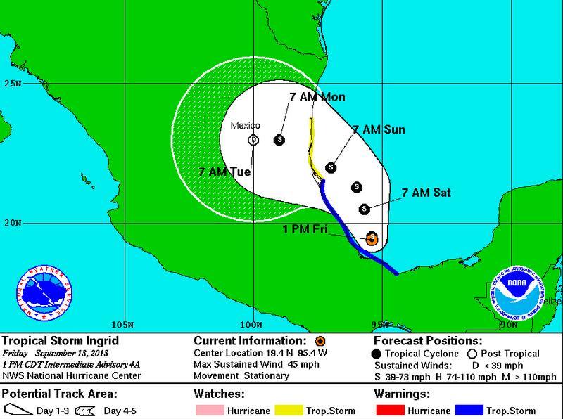
Tracking Ingrid
According to the National Hurricane Center, the forecast for ingrid is to slide northwest towards the northeast coastline of Mexico. Heavy rainfall/flooding is the primary concern, some of which will slide into southern Texas.
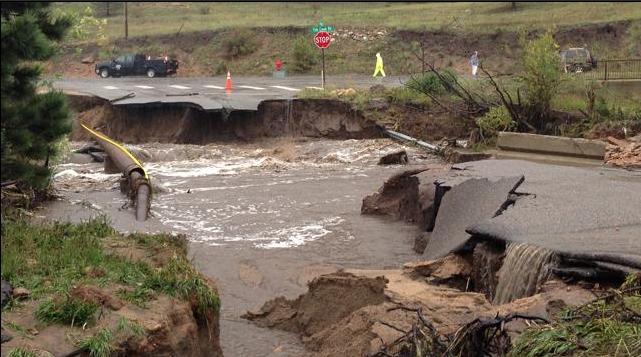
More on the Colorado Flooding
The National Weather Service is calling the flooding in Colorado a 100 year event! Up to 8"+ of rain fell in a very short amount of time that triggered flash floods that swollowed nearly everything in its path.
"KUSA - A flash flood emergency Colorado killed at least three people, prompted evacuations and destroyed several roads and highways. Multiple rescues are underway across the state. One person remains missing in Boulder County. Up to 8 inches fell in an area spanning from the Wyoming border south to the foothills west of Denver. Flooding extended all along the Front Range mountains. There are various Flash Flood Warnings in the area."
(Photo couresy: 9 NEWS KUSA)
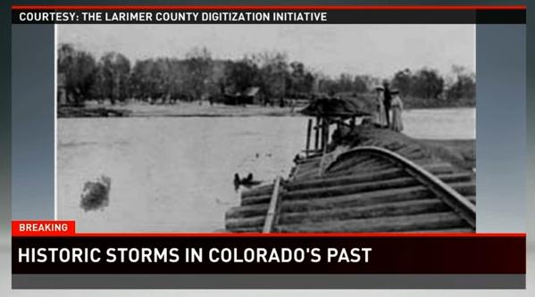
Other Historic Colorado Storms
I thought this was interesting... Here's a great list of some of the other historic storms that took place in Colorado thanks to 9 NEWS KUSA, which includes The Big Thompson Canyon Flood of 1976.
"1976 - The Big Thompson Canyon Flood happened in late July after a thunderstorm refused to move from the area - dumping more than a foot of rain in less than five hours. Record keepers say it is one of the deadliest freshwater floods in US history. In less than two hours, 570 structures were destroyed and 145 people lost their lives. The flood cost around $40 million."
See more from 9NEWS KUSA HERE:
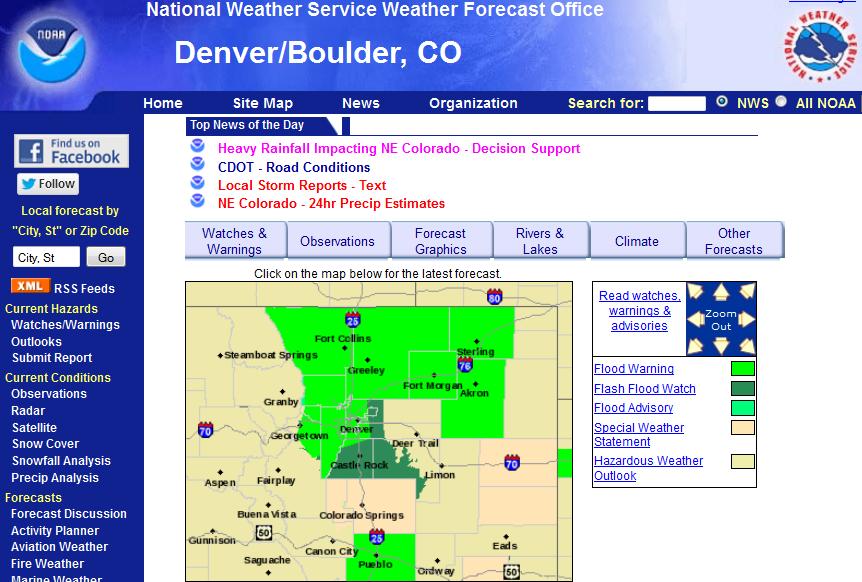
NWS Denver/Boulder, CO
The National Weather Service in Denver/Boulder, CO has been very busy with all the heavy rain as of late. Here's their website where you can keep up to date with all the latest watches/warnings and weather related information.
See their site HERE:
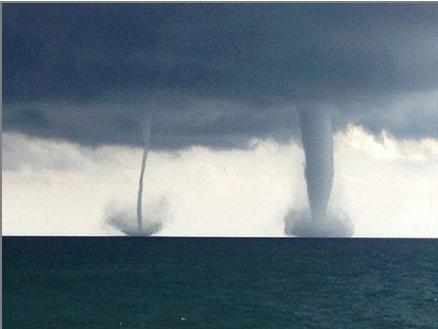
Lake Michigan Waterspouts
WOW! Severe people captured pictures/video of these amazing waterspouts over southern Lake Michigan on Thursday.
"From roughly 1:00 PM to 1:35 PM, there were two confirmed waterspouts over Lake Michigan south southeast of the city of Kenosha. A combination of the Milwaukee Terminal Doppler Weather Radar (FAA radar in Racine County) and firsthand reports place the two waterspouts just offshore between one and five miles. The parent storm that the waterspouts were associated with then continued to track southeast and off shore east of Lake County Illinois. The storm exhibited rotation on both the Milwaukee/Sullivan WSR-88D Radar and the Milwaukee TDWR and persisted for several radar scans."
See more from the NWS out of Milwaukee/Sullivan, WI HERE:
It's a bird, it's a plane... What is it?
The Duluth News Tribune has more on a mystery object found in the sky over northeastern Minnesota.
"Allison Barta of rural Cass Lake, Minn., took this photo on Sept. 2, 2013. She said the object on the top left corner is not a lens flare, and that she spotted the saucer-shaped object with the naked eye."
See more from the Duluth News Tribune HERE:
(photo courtesy: Allison Barta via the Duluth News Tribune)

A Story That's Really 'Out There'
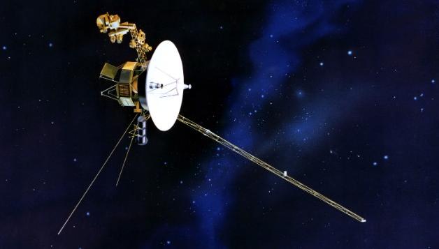
Outer space is truely amazing. The expansive void of mystery is something that many people have pondered about for decades. NASA believes that one human-made spacecraft has reached the end of our solar system! UNREAL!!
"At the edge of the heliosphere, you wouldn't know by looking whether you left the cradle of humanity behind and floated out into interstellar space. You would just see unfathomably empty space, no matter which side of the invisible line you were on.But scientists now have strong evidence that NASA's Voyager 1 probe has crossed this important border, making history as the first human-made object to leave the heliosphere, the magnetic boundary separating the solar system's sun, planets and solar wind from the rest of the galaxy."
Read more from NASA HERE:
Are You Superstitious?
Here's a story from KiroTV.com that may make you think think twice about being superstitious or not...
"Aerophobia, or fear of flying, is a relatively common phobia. Combine that with Triskaidekaphobia (the fear of the number 13) and Hexakosioihexekontahexaphobia (the fear of the number 666) and you have one anxiety-filled flight. It's not likely that there were many superstitious passengers on Friday's Finnair flight #AY666 to Helsinki. Especially considering the flight from Copenhagen was headed to HEL. That's the airport code for Helsinki."
Read more from KiroTV.com HERE:

Thanks for checking in, have a great weekend!
Don't forget to follow me on Twitter @TNelsonWNTV

No comments:
Post a Comment