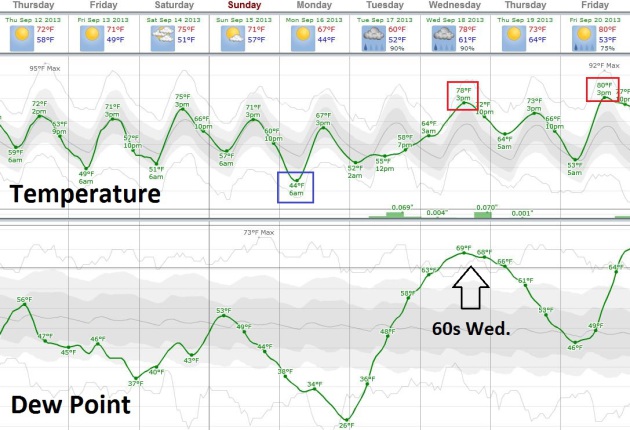
86 F. high in the Twin Cities Wednesday.
74 F. average high on September 11.
95 F. high on September 11, 2012.
.16" rain predicted for late Saturday and Saturday night.
40s possible by Sunday morning.
80 F. highs possible the latter half of next week.
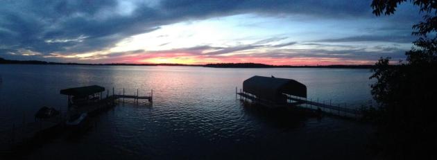
Slow Summer Fade
It's
a little like saying goodbye to a dear old friend. Covering up lawn
chairs and patio furniture. Packing up shorts & T-shirts, placing
them (reverently) into cold storage. Performing last rites on our ski
boat.
For the record: there will be more spasms of summer showing up in the coming weeks, in fact highs may hit 80F by late next week.
It's
as inevitable as gravity, property taxes and snarky Twitter posts; a
temperature correction is imminent. We shouldn't be shocked, considering
the sun angle is as high in the sky today as it was on March 30. Longer
nights are brewing up a family of progressively cooler airmasses over
Canada - at least two puffs of (refreshing!) air brushing Minnesota.
September
is running more than 7F warmer than average, to date, so we're due for a
cool slap or two. "Good sleeping weather" returns the next few nights:
50s in the metro - 40s up north.
A second, reinforcing cool front
may spark a shower Saturday night. By Monday morning kids may be
stomping their feet at the bus stop to stay warm; metro wake-up
temperatures in the mid 40s.
Welcome showers & T-storms may slosh into town by Tuesday; the ghost of Summer 2013 returns in 1 week.
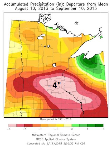
30 Day Rainfall Deficit. Much of central and southeastern Minnesota is now running a 3-4" rainfall deficit since August 10, according to the
Twin Cities National Weather Service. Map: Midwestern Regional Climate Center.
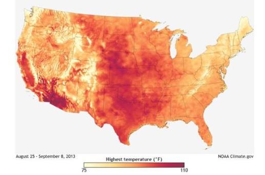
Late August - Early September Heatwave.
NOAA has more details on the unusual levels of heat over the past few weeks: "
A
heat wave struck the Midwest in late August and early September 2013.
Daytime highs were 6 degrees above average, and nighttime lows were 11
degrees above average in late August. (In contrast, the first three
weeks of the month had temperatures 2 to 8 degrees below average.)
Through September 8, all-time daily record highs were tied or broken at
328 weather stations in the Midwest and High Plains."
Map credit
above: "The map shows the hottest temperatures in the United States
between August 25 and September 8, 2013, based on data from NOAA's
Real-Time Mesoscale Analysis. Areas with higher temperatures appear red
and magenta; areas with lower temperatures appear light yellow."
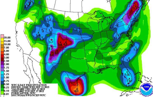
5-Day Rainfall.
NOAA models show the best chance of significant rain into next Tuesday
over New England (from a series of cold frontal passages) and South
Texas (from the soggy remains of a potential tropical storm hitting
Mexico near Tampico. A strong and persistent southerly
flow of tropical moisture may spark some 3-5" rains near Denver, capable
of sparking flash flooding.
Canadian Surge.
After peaking near 90F across much of coastal New England and surging
into the 90s over the Mid Atlantic region in recent days, the jet stream
is about to buckle, plunging a taste of late September into the
Northeast. Intense heat lingers over the Southern Plains and much of the
west, rain keeping New Mexico and Colorado cooler. 12 km. NAM
temperature forecast courtesy of NOAA and Ham Weather.
Limping Into Autumn.
By tomorrow it will (finally) feel like September, highs holding in the
60s north/east of MSP. A shower late Saturday heralds the arrival of a
second, reinforcing cool front Sunday. Jackets may be needed at the bus
stop Friday morning, again early Monday before temperatures mellow next
week. After a comfortable weekend dew points return to the sticky 60s
next week.
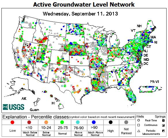
Drought: The Stealth Disaster.
USGS
has a good overview of drought in the USA and new tools available to
track not only moisture shortages in topsoil, but stream flow and ground
water (aquifers) around the nation. Here's an excerpt: "
Drought is a
stealthily incremental disaster that is much more costly to the
national economy than most people suspect. Even as the eastern states
have seen an unusually wet summer, citizens in the midsection of the
country read in May that the High Plains Aquifer could no longer support
irrigation for vast stretches of farmland in Texas and Kansas (New York Times, 5/19).
In June residents of the upper Midwest read with particular interest a
story of how drought and other factors have created historically low
water marks for the nation’s Great Lakes, putting a $34 billion shipping
industry in peril (Seattle Times, 6/15).
In August, citizens of the Southwest, many of whom depend on water from
the Colorado River basin, read that the low water levels of Lake Mead
would be minimally recharged by a record-low annual release of water
from upstream reservoir Lake Powell, the latest outcome of a 14-year
drought (Las Vegas Sun, 8/15)..."
Map credit above:
USGS. "
The
Active Groundwater Level Network contains water levels and well
information from more than 20,000 wells that have been measured by the
USGS or USGS cooperators at least once within the past 13 months. This
network includes all of these wells, regardless of measurement
frequency, aquifer monitored, or the monitoring objective."
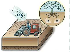
One Weird Trick To Fix Farms Forever. Using cover crops may have some serious upsides, according to this excerpt from a
Mother Jones story: "...
In
his g-droppin' Midwestern monotone, he's telling me about his cover
crops—fall plantings that blanket the ground in winter and are allowed
to rot in place come spring, a practice as eyebrow-raising in corn
country as holding a naked yoga class in the pasture. The plot I can see
looks just about identical to the carpet of corn that stretches from eastern Ohio to western Nebraska.
But last winter it would have looked very different: While the
neighbors' fields lay fallow, Brandt's teemed with a mix of as many as
14 different plant species. "Our cover crops work together like a
community—you have several people helping instead of one, and if one
slows down, the others kind of pick it up," he says. "We're trying to
mimic Mother Nature." Cover crops have helped Brandt slash his use of
synthetic fertilizers and herbicides. Half of his corn and soy crop is
flourishing without any of either; the other half has gotten much lower
applications of those pricey additives than what crop consultants around
here recommend..."
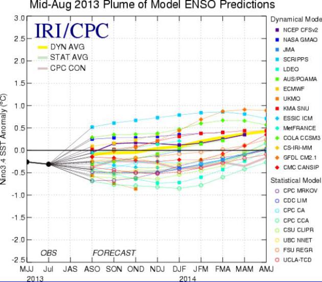
ENSO-Neutral Or Mild El Nino?
The official NOAA prediction calls for a continuation of ENSO-neutral
into the winter months (no El Nino or La Nina), but I continue to see a
slight bias toward a mild El Nino pattern returning to the equatorial
Pacific. NOAA CPC has more than you ever wanted to know
here (PDF).
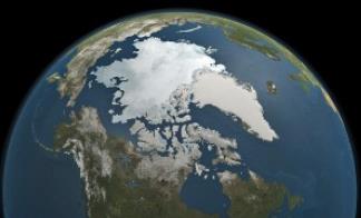
Confirmed: Greenland Reached Hottest Temperature In Modern Record This Summer. Meteorologist Jason Samenow has an update at
The Capital Weather Gang: "
After I posted news that Greenland soared to its hottest temperature on record this summer, it came to light that the toasty reading was under review by the Danish Meteorological Society
(which maintains Greenland’s records) and might be rescinded. Today,
John Cappelen, senior climatologist at the Danish Meteorological
Society, emailed me to let me know the record high of 25.9 C (78.6 F)
set on July 30 at Maniitsoq stands. “I have now accepted the record at
Maniitsoq based on further analysis,” Cappelen said..." (Image above: USGS).
Why So Quiet In The Atlantic?
Tropical meteorologists are scratching their heads (in unison),
wondering why wind shear values are higher over the Atlantic than they
should be during an ENSO-neutral situation. There's a correlation
between El Nino and fewer hurricanes, since warm Pacific water often
increases winds over the tropics. We may be sliding into a mild El Nino,
long term, but what accounts for an eerily quiet first half of the
hurricane season? In today's
Climate Matters I take a look.
Alerts Broadcaster Briefing: September 11, 2013
*
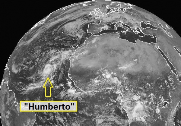
Hurricane Humberto
has formed in the far eastern Atlantic Ocean. We came within 3 hours of
setting a record for the latest (first) hurricane on record in the
Atlantic basin.
*
Humberto will not impact the USA - a series of vigorous cold frontal passages will insure a storm track over the North Atlantic.
*
8 tropical storms have formed so far in the Atlantic. Although total hurricane count will probably be lower than average,
it's still too early for complacency.
There are numerous examples of other hurricane seasons that got off to a
very slow start, but ramped up quickly in September and October.
*
Greatest risk looking out 60+ days is probably Florida and Gulf Coast.
Hurricane Humberto.
The storm is a minimal, Category 1 storm with sustained winds of 75-80
mph, much closer to Africa than the Caribbean at this hour. Saharan dust
(and an unusual amount of dry air - coupled with above-average wind
shear) has greatly reduced the number of storms in recent weeks. But as
the financial industry is keen to point out "past performance is not a
forecast of future results". Things can turn on a dime in the Atlantic -
the hurricane season is half over, but unusually warm Atlantic water
may still spin up a series of storms in the coming 2 months.
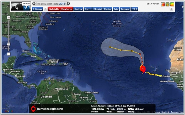
5-Day Track.
Our Alerts Broadcaster Dashboard shows a turn to the north, then west
as Humberto weakens into a tropical storm, reaching the mid-Atlantic by
early next week. A series of strong cold frontal passages sweeping out
of Canada into the Northeast should innoculate the East Coast from any
hurricane worries looking out 1-2 weeks.
Little Risk of USA Impact.
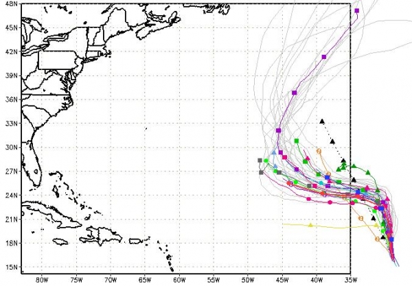
Here are the extended track forecasts for Humberto, showing an eventual
north/northeast turn as the storm gets nudged by cold fronts/wind shear
blowing out of North America.
I'm not concerned about Humberto impacting any U.S. or Caribbean facilities.
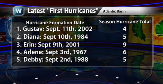
Why It's A Bit Premature For Hurricane Complacency.
Although odds now favor fewer hurricanes in the Atlantic basin than
average, due to a laundry list of meteorological factors (Saharan dust,
more dry air, more wind shear, etc). a perpetual state of low-grade
paranoia is probably warranted. There have been years that got off to a
very slow start in August and early September, only to see a sudden
spike in storm formation. "Gustav" didn't develop into the first
hurricane of the season until September 11, 2002. Later than year there
were a total of 4 hurricanes. "Erin" became the Atlantic's first
hurricane on September 9, 2001. Later that season there were 9
hurricanes, 4 of them major Category 3+ storms. If history is a guide,
as it should be, we should probably not lower our guard and state of
hurricane readiness just yet.
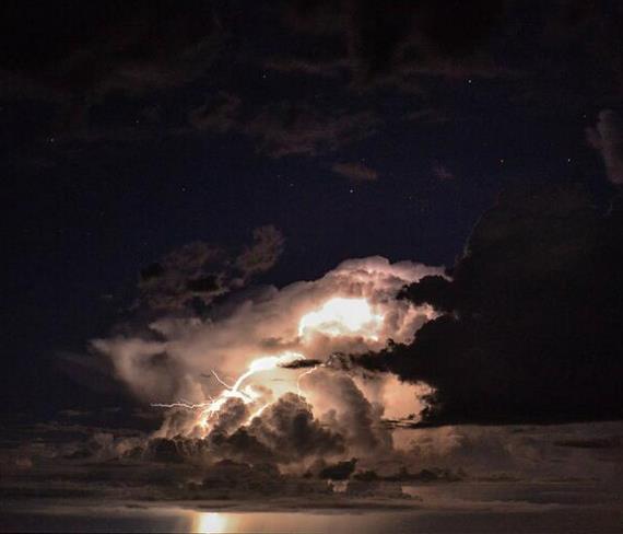
Electrifying. Here's a great shot of lightning from A.J. Pena, courtesy of the San Angelo, Texas office of the
National Weather Service.
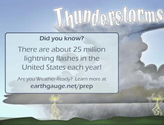
Lightning Safety. NOAA has a good link with ways to lower risk from lightning
here.
Helping Children Cope With Disasters. Here's an excerpt of a video and some good suggestions from
FEMA: You are their biggest influence. When you can manage your own feelings, you can make disasters less traumatic for your kids.
•
Encourage dialogue. Listen to your kids. Ask them about their feelings. Validate their concerns.
•
Answer questions. Give just the amount of information you feel your child needs. Clarify misunderstandings about risk and danger.
•
Be calm, be reassuring. Discuss concrete plans for safety. Have children and teens contribute to the family's recovery plan.
•
Shut off the TV! News
coverage of disasters creates confusion and anxiety. Repeated images
may lead younger kids to believe the event is recurring. If your
children do watch TV or use the Internet, be with them to talk and
answer questions.
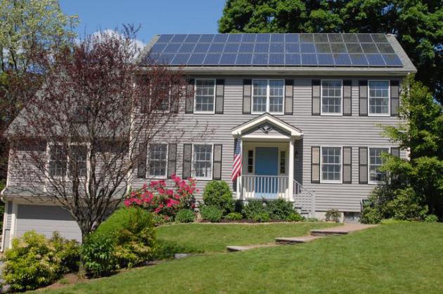
Solar Panel Is The Next Granite Countertop For Homebuilders.
Bloomberg has the story - here's an excerpt: "
Solar
panels are the next granite countertops: an amenity for new homes
that’s becoming a standard option for buyers in U.S. markets. At least
six of 10 largest U.S. homebuilders led by KB Home include the
photovoltaic devices in new construction, according to supplier SunPower Corp. (SPWR) Two California
towns are mandating installations, and demand for the systems that
generate electricity at home will jump 56 percent nationwide this year,
according to the Solar Energy Industries Association..." (Image: Wikipedia Commons).
Can Your Language Influence Your Spending, Eating And Smoking Habits? Here's a clip from a curious article at
The Atlantic: "
Chen
wondered whether languages with weak future tenses would be more
thoughtful about the future because they consider it, grammatically,
equivalent to the present. He mapped stronger and weak future-tense
languages across Europe and correlated the data with future-oriented
behaviors like saving, smoking, and using condoms. Remarkably, he
discovered that speakers with weak future tenses (e.g. German, Finnish
and Estonian) were 30 percent more likely to save money, 24 percent more
likely to avoid smoking, 29 percent more likely to exercise regularly,
and 13 percent less likely to be obese, than speakers of languages with
strong future tenses, like English..." (Image above: Reuters).
14 Oddball Reasons You're Not Dead Yet.
The list includes cotton, weather satellites, fluoride, window screens,
air conditioning and many others (that most of us take for granted day
to day).
Slate has the full list and fascinating story; here's an excerpt: "
Lifespan has doubled in the United States in the past 150 years.
This ridiculously wonderful change in the nature of life and death is
something we tend to take for granted. When we do think about why we’re
still alive, some of the big, fairly obvious reasons that come to mind
are vaccines, antibiotics, clean water, or drugs for heart disease and
cancer. But the world is full of underappreciated people, innovations,
and ideas that also save lives. A round of applause, please, for some of
the oddball reasons, in no particular order, why people are living
longer and healthier lives than ever before..."
TODAY: Sunny, windy & cooler. Dew point: 46. NW 15. High: 73
THURSDAY NIGHT: Clear and brisk. Low: 49
FRIDAY: Blue sky, less wind. Dew point: 39. High: 71
SATURDAY: Sunny start, clouds increase late PM hours. Wake-up: 52. High: 74
SATURDAY NIGHT: More clouds, slight chance of a shower. Low: 57
SUNDAY: Partly sunny, cool breeze. High: 71
MONDAY: Cool start. Plenty of sun, pleasant. Wake-up: 46. High: 69
TUESDAY: Chance of showers, T-storms. Wake-up: 53. High: 67
WEDNESDAY: Warm & humid, few T-storms. Wake-up: 63. High: 78
Climate Stories....
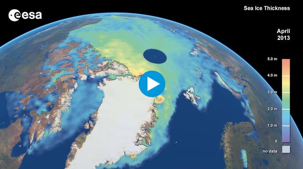
New Dimensions On Ice.
Although aerial coverage of Arctic ice has recovered from last
September's record low, there's growing evidence that overall volume of
Arctic ice may continue its steady downward spiral.
ESA has more information; here's an excerpt: "...
From
the satellite’s measurements we can see that some parts of the ice pack
ice have thinned more rapidly than others, but there has been a
decrease in the volume of winter and summer ice over the past three
years. “The volume of the sea ice at the end of last winter was less
than 15 000 cubic km, which is lower than any other year going into
summer and indicates less winter growth than usual.” While it seems
unlikely that a record minimum of sea-ice extent will be set this
September, the thinner ice at the start of summer could mean that the
actual volume of ice may reach a new low. Rachel Tilling, PhD student at
University College London, who is working with the CryoSat data stated,
“Readings from CryoSat in October, when the ice starts to refreeze,
will confirm this either way...”
Global Warming Could Change Strength Of El Nino.
ENSO (cooling/warming phases of the Pacific) seem to modulate the
impacts of warming, either amplifying the effects during an El Nino warm
phase or temporarily masking the warming during La Nina cool phases.
Science Daily has a look at how slow warming of the world's oceans may ultimately impact El Nino events: "
Global
warming could impact the El Niño Southern Oscillation (ENSO), altering
the cycles of El Niño and La Niña events that bring extreme drought and
flooding to Australia and many other Pacific-rim countries. New research
published in Nature Geoscience using coral samples from Kiribati has
revealed how the ENSO cycle has changed over the past 4300 years. This
research suggests that external changes have an impact on the strength
and timing of El Niño events. "Our research has showed that while the
development of La Niña and El Niño events is chaotic and hard to
predict, the strength of these events can change over long time spans
due to changes in the global climate," said one of the paper's authors
Dr Steven Phipps..."
Christianity And Climate Change: The Relationship Between God and green. Here's a clip from a story at
The Guardian: "...
Partly
because of the significant overlap between Christian beliefs and
politically conservative ideology, therefore, right-leaning evangelicals
were more sceptical than the general population about humans' impact on
the climate. Climate change, as the authors of the survey note, has
become as divisive within this group as it has among the broader
American public. The survey is important because it provides the first
direct comparison between the beliefs of evangelical Christians and the
rest of the US population on the contemporary environmental issue of
climate change. But debates about what the teachings of the Bible imply
for society's relationship with the natural world go back a long way.
Did God grant humans dominion and therefore domination over nature? Is
nature there simply to be utilised by us? Or does dominion mean a duty
of care – a responsibility for stewardship and a mandate to live within
our means?..."
Photo credit above: "
According to a
new survey US evangelicals are less likely than non-evangelicals to
believe climate change is happening and human activity is the cause." Photograph: Baz Ratner/REUTERS.
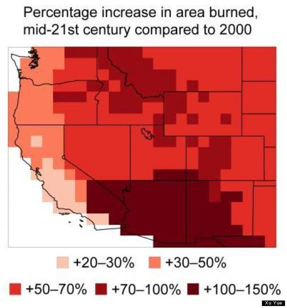
Wildfire Frequency Patterns Show That Blazes Could Double By 2050.
Dry areas are trending drier, setting the stage for larger, hotter,
more long-lasting (and expensive) wildfires in the western USA. Here's
an excerpt of a story from LiveScience and
Huffington Post: "...
Fires
are started by human activity or lightning, but it's weather that
determines the spread of fires," said Loretta Mickley, a study co-author
and atmospheric chemist at Harvard University. Relative humidity and
precipitation are also key players in wildfires, but the study found
temperature was the primary driver for future wildfires, at least in the
West's near future. From the Great Plains to California, the predicted
temperature increase is between 4 and 5 degrees Fahrenheit (2.2 and 2.8
degrees Celsius) between now and 2050. Overall, the typical four-month
fire season will gain three weeks by 2050, the researchers report. And
the probability of large fires could double or even triple. The findings
were published in the October issue of the journal Atmospheric
Environment...."
Graphic credit above: "
The area burned by wildfires is expected to double in some parts of the West by 2050." Credit: Xu Yue.
Global Warming, Ethanol And Will-O-Wisp Solutions.
The Guardian has a story taking a look at how efficient and cost-effective ethanol really is; here's a clip: "...
In discussion of climate change
and energy, there are also some common "facts" that need revisiting.
One is related to ethanol as the use of transportation fuels. It is
commonly (and mistakenly believed) that production of corn ethanol is an
energy-losing process. That is, you get less energy out of ethanol than
was put into growing, harvest, and refining the fuel. A few years ago, a
student and I did a careful study
of this "fact". We reviewed all the available literature at the time
and concluded that corn ethanol is, in fact, an energy gaining process.
Of course, there is more to the potential of corn ethanol than just
energy. So, what did we find?..."
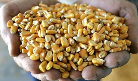
Photo credit above: "
A handful of corn is shown before it is processed at the Tall Corn Ethanol plant." Photograph: Charlie Neibergall/AP.
One-Third Of Food Wasted Worldwide Harms Environment, U.N. Says. Here's a clip from a story at
The Los Angeles Times: "
The
world throws away one-third of food produced yearly, making food waste
the third-largest source of greenhouse gas emissions behind those
produced by the U.S. and China, according to a U.N. report released
Wednesday. The U.N. Food and Agriculture Organization study found 1.3
billion tons of food is wasted every year, contributing to economic
losses that total $750 billion yearly. The focus of Wednesday's report,
however, was to examine the environmental impacts of food waste. To that
end, the U.N. estimated the carbon footprint of the problem is
equivalent to 3.3 billion tons of carbon dioxide every year..."
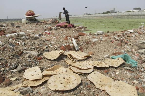
Photo credit above: "
A
U.N. Food and Agricultural Organization report released Wednesday said
one-third of all food produced in the world gets wasted, amounting to an
annual loss of $750 billion. Above, discarded bread sits along a river
in Ahmadabad, India."
(Ajit Solanki / Associated Press / June 5, 2013).


Your website is great! This post really caught my eye when I was searching around. Thanks for sharing it.
ReplyDeletehttp://www.apparelnbags.com/bayside/b960-hooded-fleece.htm