By Todd Nelson
As we say goodbye to September 2013 over the next few days, it appears that weather maps have finally starting waking up across the nation. The first half of September in the Midwest started off quiet and warm with 3 days in the 90s, which brought our total number of 90F+ days to 19; nearly 6 days above normal. Temperatures this month are running nearly 4F above average with precipitation running nearly 1.5" below average.
The soggy weather through Saturday will help to put a little dent in that deficit, but with 54% of the state considered to be in a moderate drought and 9% in a severe drought, we could use a little more.
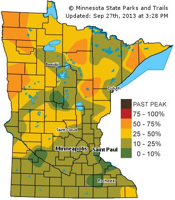
Sunday will be a better leaf peeping day, especially up north where the DNR says some areas are reaching 50%-75% of peak color. Peak colors up north are running slightly behind schedule this year, most likely due to the warm start to September, but it's not far off. Area trees in the southern half of the state are still probably a couple/few weeks away from their peak.
A more substantial cold front looks to blow through in by next weekend. One extended model is even hinting at flurries possible near the Canadian border... UGH! Stay tuned!
____________________________________________________
Todd's Conservation MN Outlook for the Twin Cities and all of Minnesota:
SATURDAY: Soggy start. Cloudy with scattered showers, possibly some thunder. High: 68 (falling into the low to mid 60s by afternoon).
SATURDAY NIGHT: Drying out. Mostly clear and cooler. Low: 47
SUNDAY: Cool start, mild finish. Bright sunshine. High: 73
MONDAY: Lukewarm sun, still too dry. Wake-up: 55. High: 78
TUESDAY: More sun and mild... Happy October? Wake-up: 58. High: 77
WEDNESDAY: Clouds increase through the day. Storms possible overnight? Wake-up: 52. High: 72.
THURSDAY: Unsettled. Scattered showers, isolated storm. Wake-up: 54. High: 68.
FRIDAY: Breezy and cooler with showers. Flurries possible north of the border late? Wake-up: 52. High: 60.
_________________________________________________
Fall Color Update
Those fall colors are starting to pop! One of my favorite things to see early in the season is the sumac. I love the bright red along the road. I had to stop and take a picture...

If you haven't seen the Minnesota DNR Fall Color Update page, check it out! It's filled with up to date information and pictures from state parks all over the state. According to the MN DNR, some across northern Minnesota are at 50% to 75% of peak color.
See the MN DNR website HERE:
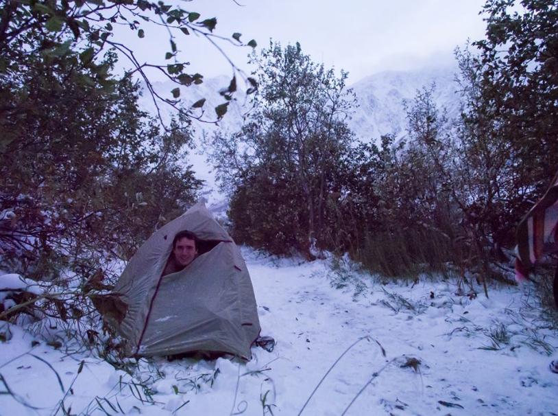
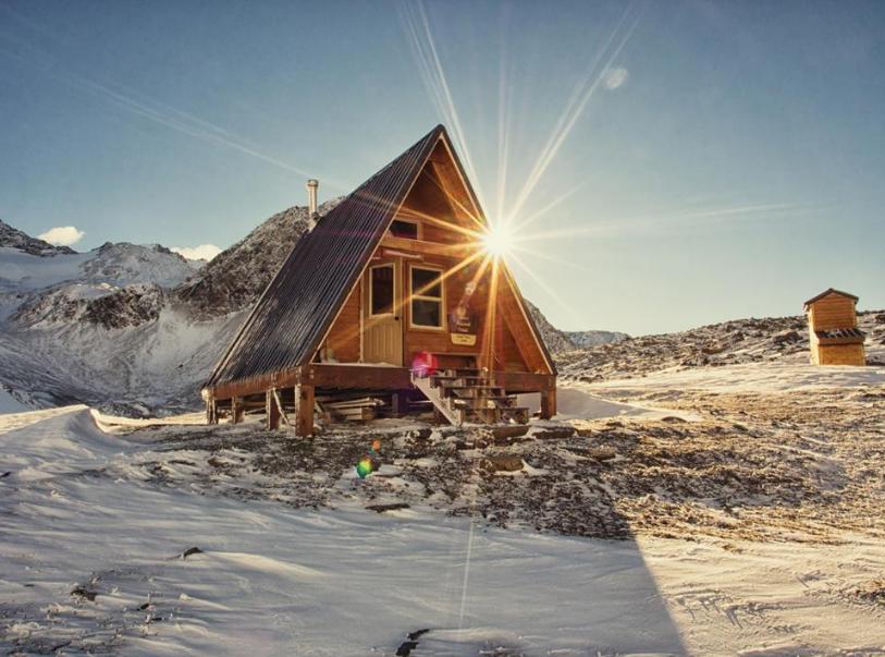
Winter Camping in Autumn?
Thanks to my good friend, John Thain, for the pictures below who is truely an adventurer! Originally from Minnesota, he took a photography job at a news station in Alaska a few years ago and struck gold. For someone that loves being outside and experiencing what nature has to offer, Alaska is quite a place. John says he went 'winter camping' in autumn... here are some of his amazing pictures!


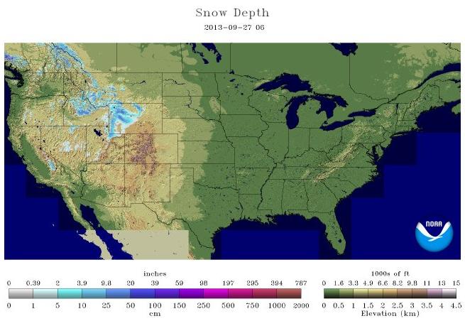
Dusting Off The Snow Maps...
This is a map that we haven't seen much of lately... It's the national snow analysis map, which shows how much of the nation is reporting snow on the ground. According to NOAA, 3.7% of the nation was reporting snow on the ground, this mainly in the Rocky Mountains.
Soggy Saturday Ahead...
Thanks to my good friend Julie Ganfield for the picture below of one of her beautiful girls, who decided to make the most of Friday's soggy weather. The good news is that we need the rain. The bad news is that it'll continue into our Saturday, when most folks would want to get outside.

Saturday Precip. Potential
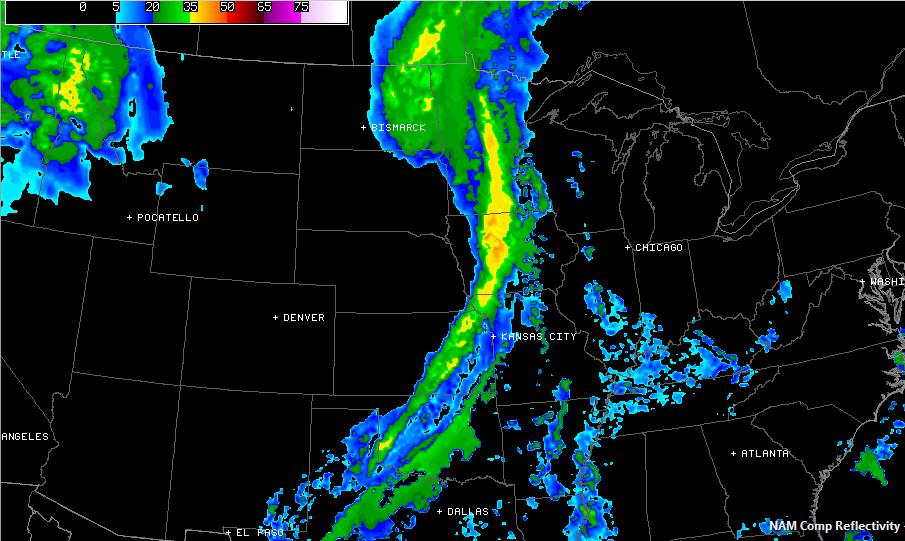
The storm system responsible for snow in the Rocky Mountains earlier this week will continue to slowly move through the Midwest on Saturday. Weather models project a fairly soggy start to the day across the Upper Mississippi River Valley. By PM Saturday, the front will move into the Great Lakes region with continued soggy weather their through the first half of Sunday. Below is the simulated radar by mid/late morning Saturday.
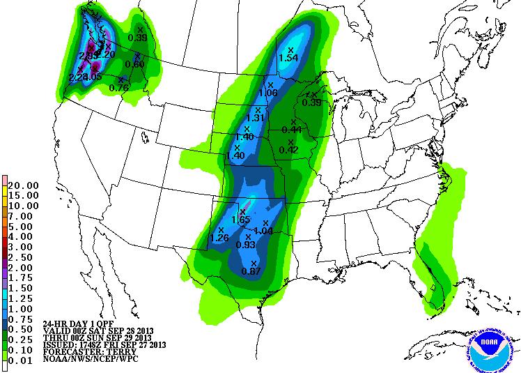
Accumulated (Saturday) Precipitation
According to NOAA's HPC rainfall forecast from 7pm Friday thru 7pm Saturday, some spots could tally nearly 1" to 2" across parts of the Midwest.
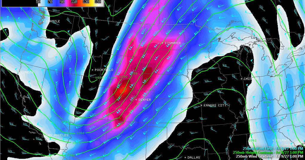
Anatomy of a Storm
it's hard to imagine the atmosphere as a 3 dimensional fluid when we look at 2D maps all the time, but it's important to look at different slices of the atmosphere for different specific weather features. Our current storm system moving through the middle part of the country has a pretty interesting wind field and I thought I'd break it down for you to show you how winds change with height...
250mb Winds
This is the 'Jet Stream' level, which is a typical cruising altitude for jetliners. Note the big dip in the wind field in the western part of the country. This is called a trough of low pressure, which indicates 'stormy' weather. This is a favorable wind for a quick flight from back from Las Vegas to Minneapolis!
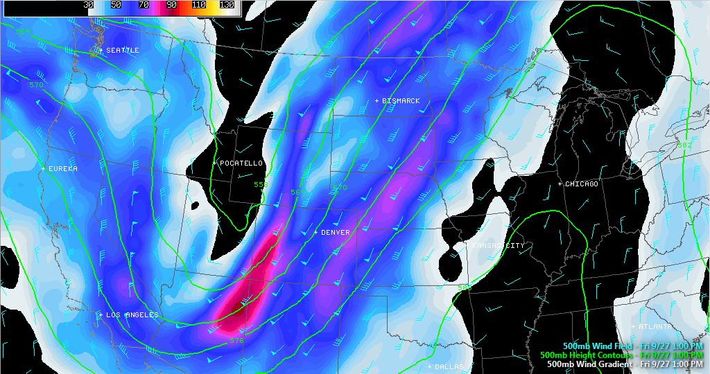
500mb Winds
At this level, wind speeds are quite as strong, but an area of low pressure may start to become a little more pronounced, which can be see closer to the UT/WY/CO border.
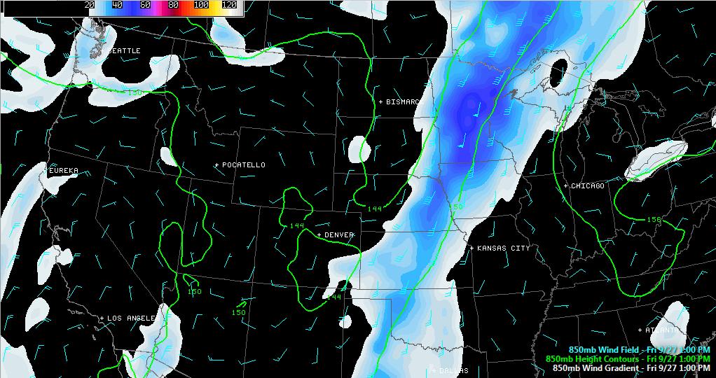
850mb Winds
In the lower part of the atmosphere, the winds taper quite a bit more yet, but notice how those 'stronger' winds are lined up a little more from south to north, rather than southwest to northeast. These are examples of wind shear, both speed and direction. In a convective or severe weather situation, this would help support longer lived, rotating, thunderstorms.
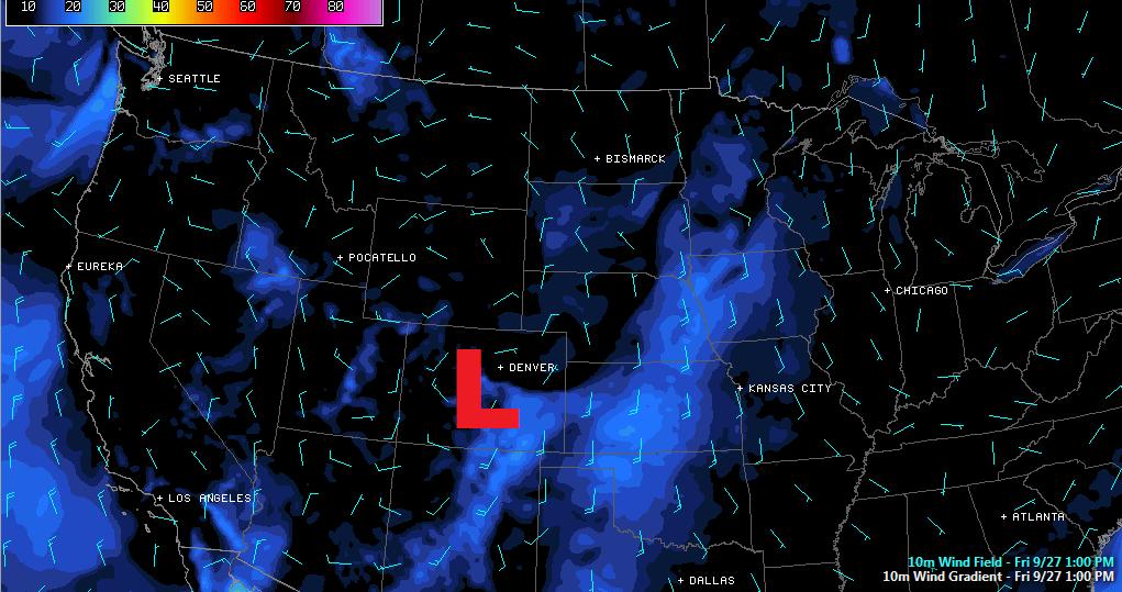
Surface Winds
The wind shear becomes even more pronounced as you get to the surface. Not only do the winds lessen even more, but the wind direction becomes even more southerly, even southeasterly across parts of the Mississippi River Valley, this is due to friction or air resistance near the ground.
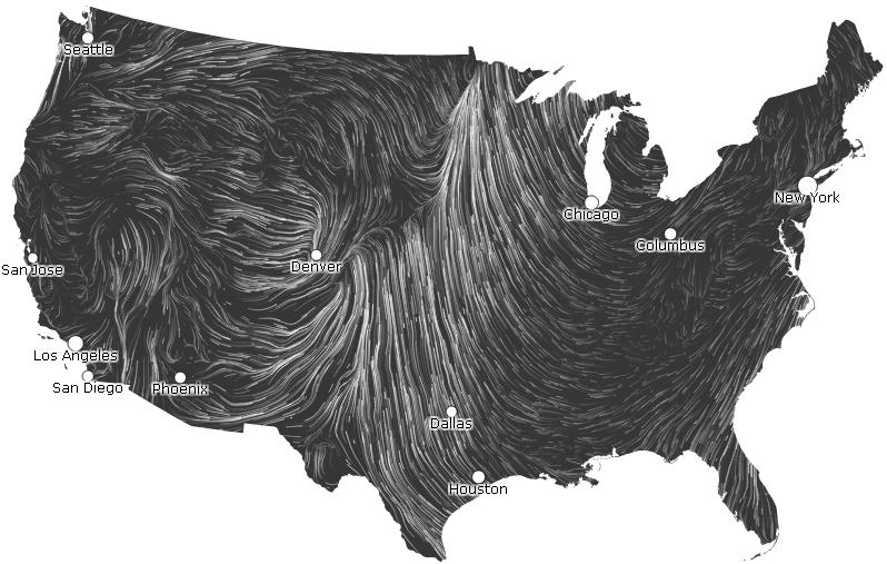
Surface Winds
Here's a different visualization of the surface winds from hint.fm/wind/ - you can actually see the center of low pressure (counterclockwise winds) near Denver and the strong southerly flow out ahead of the storm.
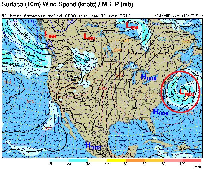
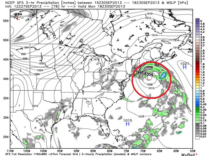
East Coast Storm?
Weather models are still hinting at the potential of a developing coastal storm early next week from the Mid-Atlantic Region to the New England States. Here's a look at two different models, which show the center of the storm offshore, but close enough to bring gusty winds and precipitation into the region as we approach the start of October.
Here's the NAM for PM Monday (Sept. 30th), which shows a pretty decent area of low pressure offshore. The wind field would be large enough to bring gusty winds into the Northeast.
Here's the GFS solution by midday Monday, which also shows the stronger area of low pressure offshore, but close enough to bring gusty winds and precipitation into the area. This will be a storm to watch and much dependent on how close it gets to the East Coast.
(image courtesy: WeatherBell)
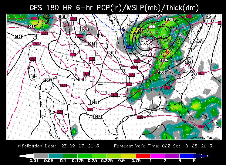
A More Substantial Cold Front...
Take a look at this, the GFS for late next week suggests another storm system over the midwest with cold enough air for the potential of flurries near the border?? It's definitely a ways into the future, but it'll be interesting to see how the models handle this particulra storm if it in deed develops. The image below suggests that infamous "540" line or freezing line dipping into the Lower 48 into Minnesota and Wisconsin by next Friday. It wouldn't be a for sure thing, but there certainly could be a few snow flurries and mix in with the light rain across the northeastern part of Minnesota if current trends hold.
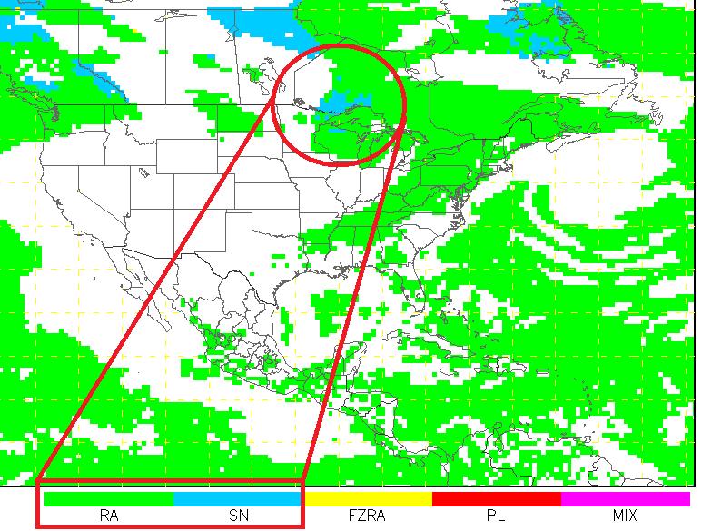
The image below shows the GFS' solution for precipitation type next Friday night. Note how it shows green and blue near the northeastern part of Minnesota, which correlates with the "540 Line" - Stay tuned for further updates.
Thanks for checking in, have a great rest of your weekend.
Don't forget to follow me on Twitter @TNelsonWNTV

No comments:
Post a Comment