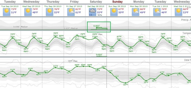
74 F. high in the Twin Cities Monday.
69 F. average high on September 23.
61 F. high on September 23, 2012.
Sprinkle possible this afternoon - next chance of significant rain: Saturday.
October 4: average date of first 32 F. low in the Twin Cities.
80 F. possible on Friday in the metro area.
Faded Fall Colors?
Yesterday
an article at The PBS Newshour caught my eye, an interview with a
professor of plant physiology who has done research into the impact of
warmer fall temperatures in recent decades. His theory? Warmer
late-season weather tampers with plant photosynthesis, resulting in
fewer "anthocyanins", the colors that remain when the green from
chlorophyll fades. One of many ways plants & animals are adjusting
to a slow-motion climate transformation.
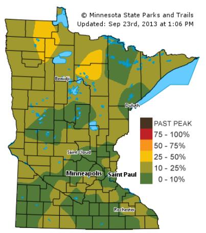
The Minnesota DNR reports
25-50 percent of leaves have ripened over northern Minnesota; peak
color in the metro still about 3 weeks away.
This still looks like
a good week to stash the lawn chairs into cold storage, maybe take out
the water toys and prepare for the inevitable winter to come. No sign of
any frost potential in the Twin Cities until the second week of
October, at the earliest.
Highs reach the 70s this week, a shot at
80F Friday before a cooler front sparks thunder, maybe even a welcome
spell of steadier rain Saturday. Sunday will be the drier, brighter day
of the weekend.
Every day of shirtsleeves from now on is a gift. 75-80F is impressive, considering the sun angle today is identical to March 19.
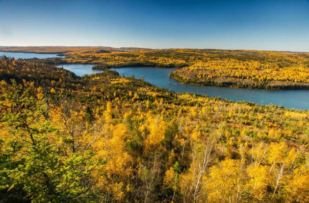
* BWCA file photo above courtesy of Steve Burns.
Fall Color Update.
Here's the latest information from the Minnesota DNR, pockets of color
up north, where 25-50% of leaves are ripening up now. It's still early
to predict how moderate drought may impact autumn color around the
state.
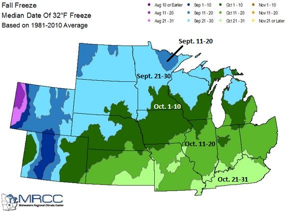
Average Date Of First Fall Freeze.
A "freeze" is defined as sustained nighttime lows colder than 28F, cold
enough to end the growing season. A "frost" falls between 28F and 32F,
when some plantlife can still survive. Map above courtesy of
NOAA and the MRCC, the Midwestern Regional Climate Center.
Mellow.
No atmospheric fireworks brewing, at least looking out 1-2 weeks. Highs
reach the 70s every day this week, if there is any sun on Friday we may
top 80F in the metro area (not bad considering the average high is in
the upper 60s). The best chance of rain: Saturday, then clearing on
Sunday and slightly cooler early next week. ECMWF guidance above
courtesy of Weatherspark.
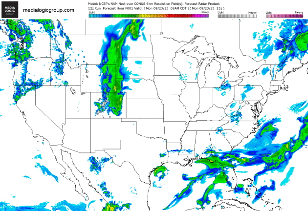
Florida Soaking - Retrograding Low For New England.
Weather systems usually track from west to east. Every now and then
systems stall, even drift west or southwest. Such will be the case
across northern New England with a cold rain approaching from the
northeast. A stalled front fueled with moisture leftover from last
week's "Invest 95" tropical depression will result in more torrential
rain for Florida, especially the Tampa area. 84 hour NAM Future Radar
product courtesy of NOAA and Ham Weather.
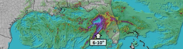
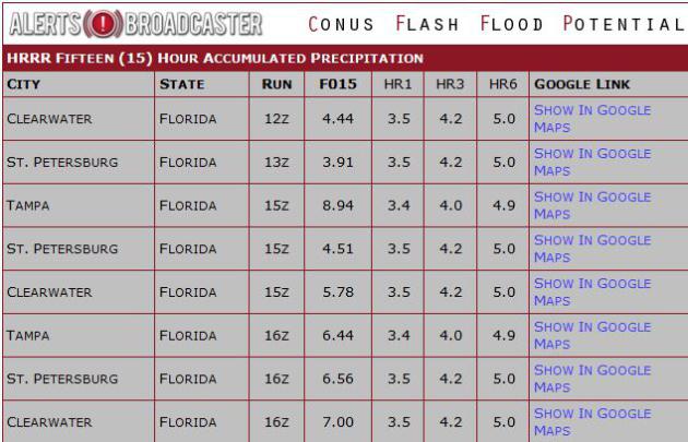
A Tropical Storm's Worth Of Rain?
High-resolution HRRR models are hinting at enough rain for serious
flash flooding along the west coast of Florida, centered on Tampa - St.
Petersburg on Tuesday.
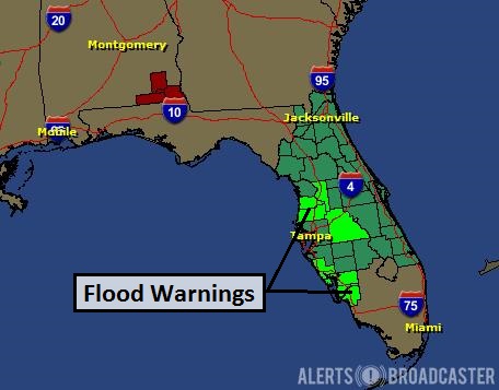
Flash Flood Potential.
Our internal models show a potential of as much as 6-9" of rain for
Tampa, Clearwater and St. Petersburg, Florida by Tuesday afternoon.
Flooding Already Underway.
NOAA has issued a Flash Flood Watch for much of Florida, Flash Flood
Warnings reported from Ft. Myers and Sarasota into the Tampa - St. Pete
market. Additional "waves" of heavy showers and T-storms may prolong
flooding into Wednesday, possibly Thursday.
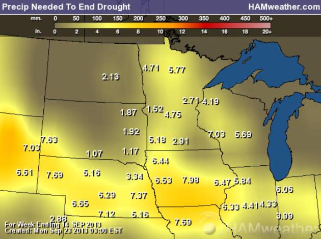
Rainfall Required To End The Drought.
Latest data from NOAA and USDA show anywhere from 2-6" of rain is
needed to put a serious dent in the drought - the best odds of this
coming in October, as more significant storms drop heavy/widespread
rain. In theory. Map: Ham Weather.
Nationwide Perspective.
The greatest rainfall deficits are showing up over Texas, Arkansas,
northern Missouri and much of Iowa, on west into Wyoming, Montana and
Idaho. Pockets of abnormally dry weather are beginning to show up in the
Mid Atlantic region; New York City now running a 3.6" rainfall
shortage. Bad news for farmers in Central Park.
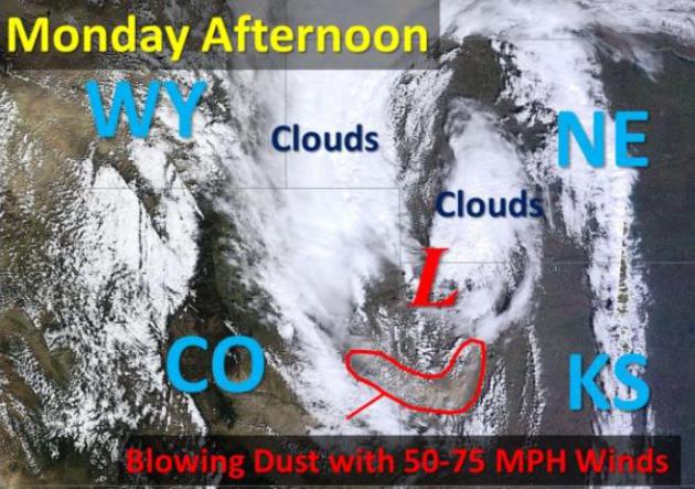
Blowing Dust. The Twin Cities National Weather Service tweeted out
this image, showing the blowing dust that closed portions of I-70 in Kansas on Monday.
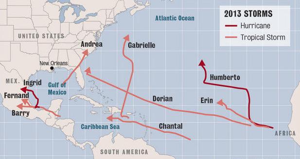 2013 Hurricane Season Quiet, But Not Over, Experts Warn
. Here's a clip from a good article and explainer from
NOLA.com in New Orleans: "...
The
thunderstorms that make up a tropical cyclone are formed when moist air
is rising, so the sinking air is believed to be suppressing
development. Compounding the suppression factor are strong upper level
winds that are shearing off the tops of whatever thunderstorms do form,
he said. "This year's Tropical Storms Chantal, Dorian, Erin and Gabrielle
each dissipated when they ran into this environment," Feltgen said.
"Several tropical waves coming across the tropical Atlantic in recent
weeks (in what's referred to as the Cape Verde season because storms
tend to form near the Cape Verde islands off the coast of Africa), ran
into these environmental issues and failed to develop any further..."
Graphic credit: NOLA.com, The Times-Picayune.
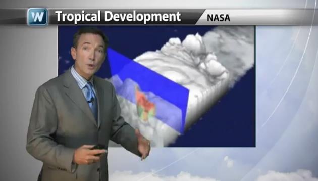
Supernaturally Quiet Tropics.
An unusual amount of subsidence (dry, sinking air) and wind shear over
the central and eastern Atlantic may be at least partially responsible
for a lack of hurricane activity (only 2 hurricanes so far in the
Atlantic - neither affected the USA). In today's edition of
Climate Matters we look at the dynamics that form hurricanes, and explain why it's still too early to let our guard down: "
WeatherNationTV
Chief Meteorologist Paul Douglas goes over some of the recent activity
in the tropics or lack thereof. He also shows that just because it's
been quiet so far doesn't mean it's time to be complacent."
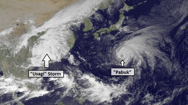
Typhoon Pabuk Heading North As Usagi Winds Down.
Typhoon Usagi brushed Hong Kong will hurricane-force wind gusts early
Monday - it's now fizzling into a extra-tropical low pressure system
over China, still squeezing out torrential rains. "Pabuk" should pass
east of Tokyo, Japan in the coming days. Details from
NOAA's Environmental Visualization Laboratory: "
Typhoon
Pabuk in the northwest Pacific Ocean is moving slowly to the northwest,
but is forecast to veer northeast in 48 - 72 hours, skirting the east
coast of Japan and picking up speed. The remnants of Typhoon Usagi are
over eastern mainland China after coming ashore on Sunday September 22
with winds in excess of 100 mph. This image was taken by MTSAT-2 at
0530Z on September 23, 2013."
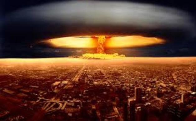
The Time The U.S. Military Came THIS Close To Dropping A Nuclear Bomb On North Carolina.
I had no idea we came this close to accidently detonating a nuke 250
times more powerful than the bomb dropped on Hiroshima. Slate has the
remarkable story - here's a clip: "...
A declassified document
obtained by author Eric Schlosser sheds new light on the 1961 Goldsboro
accident, in which a U.S. Air Force B-52 broke apart in midair over
North Carolina, dropping a pair of Mark 39 nuclear bombs on the
countryside below. The accident is not news, but just how close the
military came to wiping out a swath of the Eastern Seaboard has long
been debated. For years the military insisted that the hydrogen bombs
were never in danger of detonating. The secret document, written by a
nuclear weapons safety supervisor in 1969 and first published by The Guardian today,
makes it clearer than ever that was not the case. In fact, three of the
four safety mechanisms on one of the bombs were unlocked in the course
of the fall. By the time the bomb reached the ground, the only thing
preventing it from detonating was a single, simple, low-voltage switch. A
short-circuit of that switch as a result of the mid-air breakup—“a
postulate that seems credible,” the supervisor writes—could have
resulted in mass destruction..." (Image credit
here).
Is It O.K. To Watch Football?
A violent and dangerous sport? Absolutely. Modern-day gladiators?
Possibly. If it's not O.K. to watch football I have no idea how I'm
going to spend my weekends between now and early February. But where do
you draw the line? What about NASCAR, competitive downhill skiing,
gymastics, ice hockey, even Equestrian horseback riding? There are risks
everywhere we turn, but this story deals with relative risk, and the
potential for debilitating, lifelong injuries. Weighing the various
risks,
The New Yorker
has an article that made me feel a bit guilty rooting for the Broncos
and Peyton Manning (on my fantasy football team) last night - here's the
introduction: "
In the past few years—thanks to a combination
scientific study; legal action from current and former players;
dedicated reporting; and an increased, though surely belated, openness
on the part N.F.L. executives—football fans have been forced to confront
something that we already knew from plain sight: the sport is dangerous
for the people who play it—for their joints, and bones, and muscles,
and, especially, for their brains. The recent settlement between the
N.F.L. and thousands of former players or their families, who were suing
the league for what they alleged was its failure to inform players
about the long-term health risks of concussions and other head trauma,
does not resolve the issue for fans..."
* The Top 10 Most Dangerous Sports? Here's a short list from
thetoptens.com.
TODAY: More clouds than sun, dry. Winds: S 10. High: 71
TUESDAY NIGHT: Patchy clouds, dry. Low: 50
WEDNESDAY: More sun, very pleasant. High: 75
THURSDAY: Blue sky, warm PM breeze. Wake-up: 56. High: 79
FRIDAY: Summer breeze with a touch of humidity. Late-day T-storm. Wake-up: 60. High: 81
SATURDAY: Periods of rain, cooler. Wake-up: 61. High: 72
SUNDAY: Partly sunny and drier, comfortable with "average" temperatures for late September. Wake-up: 52. High: 68
MONDAY: Plenty of sun, drama-free. Wake-up: 49. High: 67
Climate Stories...
Could Climate Change Mean A Less Colorful Season? I saw this story on Sunday - thought it was worth sharing on the blog. Here's a video and excerpt from
The PBS Newshour: "....
And
this season may also be the time catch the autumn leaves changing...
while you still can. Howie Neufeld, Professor of Plant Physiology at
Appalachian State University believes climate change may reduce the effect of the leaves changing colors.
In the fall, trees begin to lose their chlorophyll, which gives leaves
their green color, and start synthesizing anthocyanins, which give
leaves their red color. Orange and yellow colored leaves come from
leaves without anthocyanins, which reveal underlying colors as the green
from the chlorophyll fades. Neufeld believes warmer temperatures may
tamper with plant photosynthesis, resulting in less anthocyanins being
synthesized--in short, fewer bright colors in the fall leaves (like
those in the video below)..."
Video credit above: Vimeo/Jamie Scott.
Human Role In Warming "More Certain" - U.N. Climate Chief. The BBC reports; here's an excerpt: "
Scientists
are more certain than ever that greenhouse gases from human activities
are heating the planet, the head of the UN's climate panel says.
Rajendra Pachauri made the comments in an interview with BBC News. The
panel is due to deliver its latest report on the state of the climate
later this week in Stockholm, Sweden. Its last report was criticised
after an error on glaciers unveiled other flaws, but Prof Pachauri said
procedures had been reformed and strengthened. He also dismissed
suggestions of a slowdown in global warming. "There’s definitely an
increase in our belief that climate change is taking place and that
human beings are responsible,” he told me..."
The Hottest Decade On Record, Despite Cooling Influences. Here's an excerpt of a PDF explaining what's really happening from
Climate Nexus:
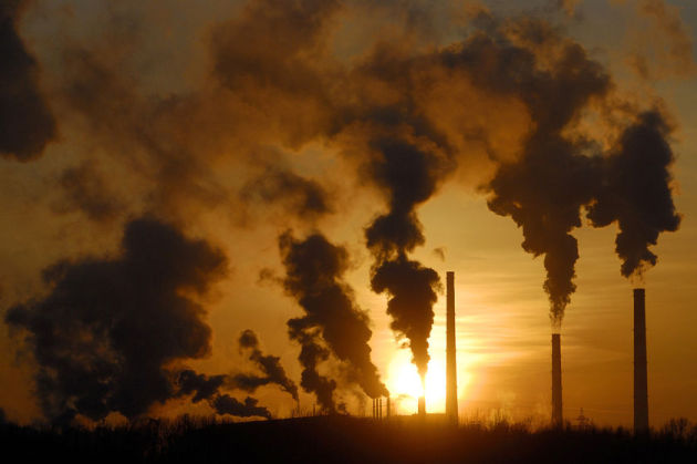
An Important Step On Global Warming. Here's a clip from an Op-Ed at
The New York Times: "...
The
rules would restrict emissions at new natural gas-fired plants to 1,000
pounds of carbon dioxide per megawatt-hour, and at new coal plants to
1,100 pounds per megawatt-hour. Because existing coal plants, even
advanced ones, produce about 1,800 pounds per megawatt-hour, industry
will find it virtually impossible to build new coal plants without
capturing and storing some or all of their carbon emissions — a
technology the administration has promised to promote but which has not
been commercially demonstrated on a wide scale. New gas-fired plants
should easily fit under the new limits because they now produce only
about 800 to 850 pounds per megawatt-hour. The rules for new plants are
far less costly and contentious than the rules the Environmental
Protection Agency is now drawing up to regulate thousands of existing
power plants, the ones producing all those emissions..."
Study: Climate Change To Increase U.S. Thunderstorms.
In truth, confidence levels about a warmer, wetter atmosphere spawning
more severe thunderstorms is not as high as other phenomena (like
extreme rainfall amounts). There is still considerable uncertainty.
Here's an excerpt from a story at
USA Today: "...
Deadly
and destructive thunderstorms -- and the violent tornadoes they produce
-- are forecast to see a "robust" increase across parts of the USA in
upcoming decades due to climate change, says a new study published
Monday in the Proceedings of the National Academy of Sciences.
Springtime severe thunderstorms could increase by as much as 40% over
the eastern USA by the end of the century, says lead author Noah
Diffenbaugh of Stanford University. The study is one of the first that's
found such a link between climate change and severe storms. Most
previous research has been inconclusive..."
Magical Climate Contrarian Thinking Debunked By Real Science.
The Guardian has the story - here's an excerpt: "
One of the most important concepts to understand when trying to grasp how the Earth's climate works, is that every climate change must have a physical cause. This principle was the basis of our new paper, Nuccitelli et al. (2013).
Over the past century, climate scientists have developed a solid
understanding about how the climate works and the physical mechanisms
that cause it to change. By building that knowledge into complex climate
models, scientists have been able to accurately reproduce past observed
global surface temperature changes. It's not sufficient to say global
warming is the result of "a natural cycle" – which cycle is causing the
change? For example, is it due to the Earth's orbital cycles around the Sun, which operate very slowly over periods of thousands of years? Is it changes in solar activity, which has on average remained flat and even declined slightly over the past 60 years? Is it ocean cycles, which shift heat between the oceans and air, and don't cause the Earth to accumulate more heat?..."
Climate Change: IPCC Issues Stark Warning Over Global Warming. Here's a clip from an article at
The Guardian: "...
Extreme
weather events, including heatwaves and storms, have increased in many
regions while ice sheets are dwindling at an alarming rate. In addition,
sea levels are rising while the oceans are being acidified – a
development that could see the planet's coral reefs disappearing before
the end of the century. Writing in the Observer ahead of the report's release, the economist and climate change
expert Lord Stern calls on governments to end their dithering about
fossil fuels and start working to create a global low-carbon economy to
curtail global warming. Governments, he states, must decide what "kind
of world we want to present to our children and grandchildren..."
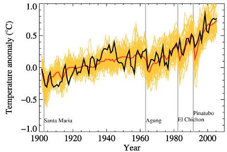
Image credit above: "
Global
mean near-surface temperatures from observations (black) and as
obtained from 58 simulations produced by 14 different climate models
driven by both natural and human-caused factors that influence climate
in the 2007 IPCC report (yellow). The mean of all these runs is also
shown (thick red line). Vertical grey lines indicate the timing of major
volcanic eruptions."


No comments:
Post a Comment