42 F. high in the Twin Cities Tuesday.
52 F. average high on October 29.
45 F. high on October 29, 2012.
Trace of rain fell yesterday at MSP up until 7 PM.
5.5" snow fell at MSP on October 29, 1905
October 29 Weather History for Minnesota:
1951:
A early snow storm dropped as much as 8 inches of snowfall in north
central Minnesota. Mora had 8 inches, while Long Prairie received 6
inches. Glenwood, Little Falls, Morris, and New London all had 5 inches
of new snow. Meanwhile, surrounding areas received a couple of inches.
1936: Gale dust storm causes damage in Central Minnesota. Heavy wind damage is reported in Stearns County.

"
...123
million Americans, more than a third of the entire country, live in
coastal counties, a number that increased by 39% from 1970 to 2010.
About 3.7 million Americans live within just a few feet of the sea at
high tide, putting them at even more extreme risk for coastal flooding..." - from a Time Magazine retrospective of Sandy, details below.
Map
above showing Sandy storm surge flooding vs. Cat 4 storm surge
potential flooding courtesy of the Capital Weather Gang - details below.
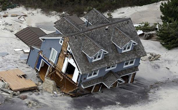
650,000 U.S. homes damaged or destroyed by Sandy. Source: NBC News.
"...
The
results highlight four main factors that control storm surge: The shape
of a coastline, the depth of coastal water, and the wind speed and
storm size prior to landfall, specifically, about 18 hours before a
storm hits land... - from a Live Science story below focused on why
the Saffir Simpson Scale for rating hurricane intensity can't be relied
upon for estimating storm surge heights.
Communicating Risk
Sandy
was a poignant reminder that meteorological gains (better models, more
accurate hurricane tracks) have outpaced our ability to effectively
communicate risk. Social science matters; how people process information
and make decisions that keep them safer.
Sandy took a
1-in-700-year turn into New Jersey - virtually unheard of in late
October. A mash-up of Nor'easter & dying hurricane, Sandy was 3
times larger than Katrina; tropical storm force winds encompassed a
1,000 mile radius. Hurricane warnings were (mistakenly) discontinued as
Sandy approached land but the combination of high tide, a full moon
& sustained winds near hurricane-force pushed an historic 14 foot
surge into lower Manhattan.
We knew it would be bad, but it's hard
communicating impacts of a storm that is so outside the norm; an almost
incomprehensible weather event. Rising sea levels have doubled the risk
of similar storms for many U.S. coastal regions.
Up to 1 inch of rain may fall by Thursday morning, but we should dry out in time for Halloween. No blizzards this year.
A
dry weekend is shaping up; models hinting at 50F early next week - a
cold rain on Tuesday, maybe ending as a little wet snow next Wednesday.
No accumulation in sight - yet. Old Man Winter continues to pull his
punch.
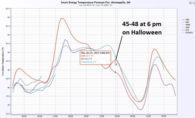
A Perfectly Average Halloween.
The rain should taper early Thursday, a few light (rain) showers still
possible over central Minnesota and portions of Wisconsin. Expect mostly
cloudy skies, a northwest breeze, and 6 PM Trick or Treat temperatures
in the mid to upper 40s. Right where they should be on October 31.
Graph: Smart Energy.
A Faint Whiff Of Warmth.
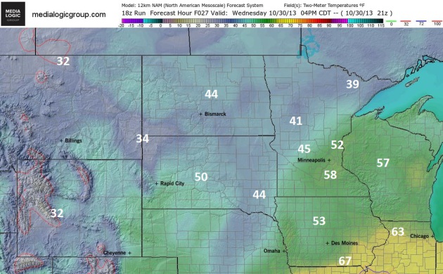
Yes, now we get excited when the mercury is forecast to top 50F, a new
definition of "warm front". 12km NAM model data from NOAA shows low to
mid 50s by 4 PM this afternoon, 60s pushing into Iowa and Illinois,
where a few strong T-storms may bubble up. Map: Ham Weather.
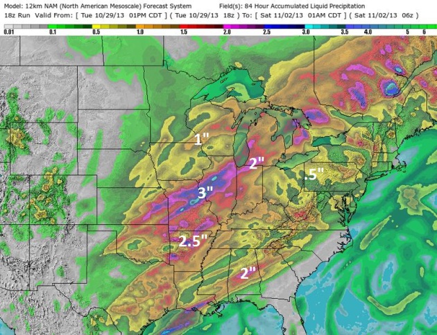
Putting Another Minor Dent In The Drought. NAM model data shows some 1"+ rainfall amounts over far southeastern Minnesota, closer to .25" for the Twin Cities, maybe ..1 to .2" for St. Cloud. Some 2-3" amounts are expected
from near Kansas City to Peoria and Chicago, capable of minor flash
flooding. 84-hour NAM data courtesy of NOAA and Ham Weather.
A Halloween Trick.
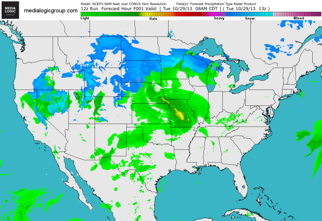
At least we're not tracking any blizzards (or ill-timed hurricanes)
this year. 4km NAM model simulations show a full latitude trough
spinning up a storm which should track from near Denver to the Twin
Cities, pushing strong T-storms across the Mississippi Valley, drenching
the Midwest and Great Lakes with significant rainfall amounts. The East
Coast may hang onto dry weather Thursday evening before showers and
T-storms arrive. Loop: Ham Weather.
Mild Start To November; A Slop-Storm Next Week?
ECMWF guidance from Weatherspark shows low to mid 50s today, another
shot at 50F early next week after a dry, partly sunny weekend. The next
storm spins up Tuesday, starting as rain, but enough cold air may mix in
at the tail-end of that storm for a changeover to wet snow. It's too
early for specifics, but some level of wintry weather is possible by the
middle of next week.
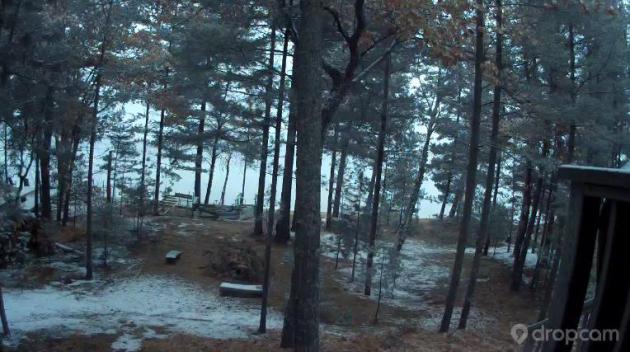
Nuisance Snow.
This was the scene from my trusty "Dropcam" webcam up at our cabin on
Pelican Lake, near Breezy Point around midday Tuesday, showing a light
coating of snow on the ground. Not exactly breaking news, but yes, it
did snow (a little) up north.
17 Images That Tell The Story Of Sandy Slamming The East Coast.
Here is a terrific summary of Sandy, data and images that tell the
story of this 1 in 700 year storm, courtesy of the Washington Post's
Capital Weather Gang: "...
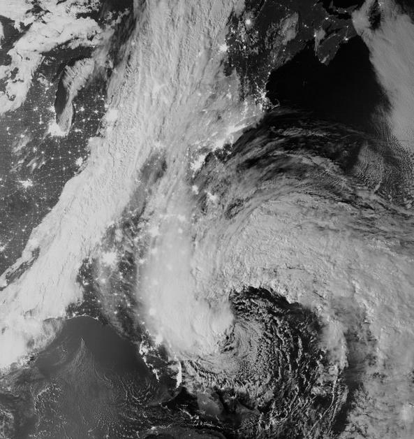
The Suomi NPP VIIRS
satellite got some of its first stunning imagery during Sandy. With the
storm still off the Florida coast, clouds streamed north up into New
England. An advancing cold front that would help supercharge Sandy is
also quite vivid."
Image credit above: CIMSS/SSEC/University of Wisconsin-Madison and NOAA/NASA/JPSS Project.
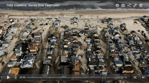
A Year After Sandy, Living Dangerously By The Sea.
What's the definition of insanity? Doing the same thing over and over,
expecting a different result. At some point, as seas continue to rise,
rebuilding next to the ocean won't make much sense - it will become
prohibitively expensive, and U.S. taxpayers won't keep picking up the
tab.
Time Magazine has the article and video clip; here's an excerpt: "...
Here’s a fact about Sandy that might surprise you: when the storm made landfall in New Jersey on Oct. 29, it wasn’t actually
a hurricane. Its wind speed had fallen below the 74 m.p.h. sustained
velocity that’s needed to change a tropical storm into a hurricane.
Instead Sandy was officially a “post-tropical cyclone.” And while the
storm certainly dropped a lot of water
on the belt of heavily affected states between South Carolina and New
York — 7 in. or more in many places — it wasn’t the precipitation alone
that led to the devastating floods that followed in its wake, causing
more than $68 billion in damages. What made Sandy devastating was its
size, covering more than 1,000 miles, the coastal storm surges it
caused, and the way the force of the cyclone — which took an unusual
path almost directly at the East Coast — pushed the sea and rivers up
and over onto land, spilling out into streets and inundating nearby
infrastructure..."
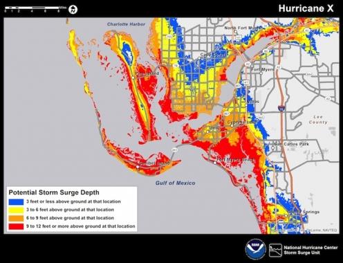
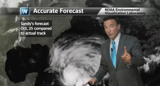
Experts Say Sandy Showed Limits Of An Accurate Forecast. Meteorologist Andrew Freedman at
Climate Central
analyzes the forecasts (public and private sector) leading up to a very
unconventional storm unlike anything anyone has ever seen before.
Social science, how we communicate threats to life and property, haven't
kept up with meteorological breakthroughs; here's an excerpt: "..
.Spurred by Sandy as well as Hurricane Isaac, which struck Louisiana in 2012, the NWS is developing storm surge warnings
as well as mapping tools that will allow forecasters to bring the
threat closer to home for the public. Jamie Rhome, the storm surge lead
for the NWS, said that Congress appropriated funds for storm surge
forecasting improvements in the wake of Sandy, but that much of the work
had already begun before the storm. The $10 million in post-Sandy funds
devoted to storm surge modeling will accelerate the development of
these warnings and enable the NWS to deliver this nationally earlier
than expected. The NWS is also working to roll out experimental
inundation graphics in 2014 and storm surge warnings in 2015. These
warnings, and the maps used to convey them, are being designed
collaboratively between forecasters and risk communication experts..."
Graphic credit above: "A prototype of NOAA's new storm surge depth maps, which will be in use starting in 2014." Credit: NOAA/NWS.
Communicating Weather Risk.
Technology is great, but the weakest link is often communications. How
can you accurately convey the level of risk so people and businesses can
take appropriate measures? This becomes even more challenging when
you're faced with something you've never seen before: a strange, mutant
combination of Nor'easter and dying hurricane, approaching from the
east, in late October? In today's edition of Climate Matters we take a look at social science, and how Sandy's scope, as well as its path, was nearly unprecedented: "It's
been a year since Sandy made landfall near Brigantine, New Jersey. The
storm which had a 1 in 700 year track turned into one of the costliest
storms in history impacting 24 states. WeatherNation Chief Meteorologist
Paul Douglas looks at the factors that made Sandy so destructive."
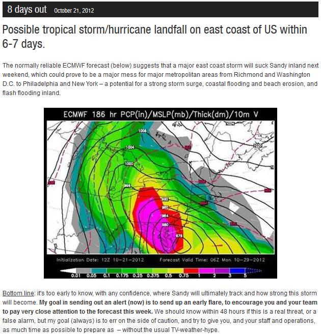
8-Day Heads-Up On Superstorm Sandy.
Leveraging ECMWF guidance we were able to provide an 8-day advance
warning to our clients last year - Sandy's landfall wound up being
farther north (near Atlantic City), but the "Euro" did a remarkable job
overall tipping off meteorologists of an eventual, westward "hook" to
the storm track. More details from Alerts Broadcaster.
Water, Not Wind, Makes Storms Like Sandy Dangerous.
It turns out that the Saffir Simpson Scale (rating hurricanes from 1 to
5 based on sustained winds) does not do a good job estimating storm
surge, which is the biggest threat to life and property. Live Science has a good explainer; here's a clip: "...This
is because the official Saffir-Simpson Hurricane Scale is based
entirely on a storm's wind speed, which, it turns out, has little to do
with the surge it produces. "There is no relationship," James Brinkley, a
member of the National Hurricane Center's storm surge unit, told
LiveScience, citing a number of inconsistent figures from past
hurricanes. For example, Hurricane Katrina,
which was a Category 3 storm, had a storm surge of more than 20 feet (6
m) in some locations. Hurricane Charley, on the other hand — which hit
Florida in 2004 — was a Category 4 storm, but only caused storm surges
of about 8 feet (2.4 m), Brinkley said..."

Turning Hurricane Sandy's Scars Into Badges Of Survival.
Showing off waterlines from Sandy's storm surge has become something of
a status symbol with some residents of New York and New Jersey, as
described in
The New York Times: "
It
was a foul, filthy thing that marred the aesthetics, something to scrub
off or paint over, something to just get rid of. It stood for what once
was: a sour reminder of the thundering water, unimaginable wreckage and
exponential wounds. No one would want it anymore, would they? Marco Pasanella
engagingly pointed out the jagged white line that ran the length of the
brick wall inside his wine shop, Pasanella & Son Vintners, in the
South Street Seaport. It was about six feet above the floor. It was
going to stay right there. The waterline from Hurricane Sandy..."
Photo credit above: "Marco
Pasanella, owner of Pasanella & Son Vintners in the South Street
Seaport, stood in front of the interior brick wall, which still has a
waterline." Nicole Bengiveno/The New York Times.
Sandy Was Our Social Storm, But At What Cost?
Uploading all those Instagram photos of flooding seemed like a good
idea at the time, until the power failed, there was no way to charge
your iPhone, and now you couldn't reach your loved ones.
Mashable has an interesting story about Sandy and social media; here's a clip: "..."
A
lot of the messaging when we announced the feature was to encouraging
folks to take photos, but more importantly to take photos safely," said
Shayne Adamski, director of digital communications for FEMA. "We did not
want folks to put themselves in harm's way just to get a photo."
Adamski added that taking and attempting to upload photos or video may
not be a productive use of battery life during situations where a person
may be without power for days at a time. He said priority No. 1 in
these situations should be notifying friends and family members of your
status so those people do not have to call emergency managers to find
out about you..."
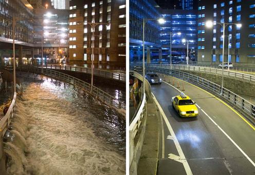
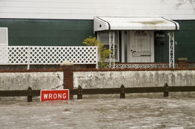
Photo credit above: "This combination of Oct. 29, 2012 and Oct. 20, 2013 photos shows sea water flooding the
entrance to the Brooklyn Battery Tunnel in New York as Superstorm Sandy
struck the city, and traffic entering nearly a year later." (AP Photo/John Minchillo).
Hurricane Sandy Anniversary: Dealing With The Psychological Scars One Year Later.
Psychologists talk about a weather-version of PTSD, or Post Traumatic
Stress Disorder, the same thing tornado and flood victims also cope with
post-storm. Here's a clip from a story at
Fox News: "...
Coming
up on an anniversary of something like a traumatic event can ramp
things up and people can feel highly anxious and depressed,” Dr. Rachel
Yehuda, director of the traumatic stress studies division at the Mount
Sinai School of Medicine in New York City, told FoxNews.com. “It’s a
time where there is a natural spike in symptoms, especially on a first
year anniversary.” According to Yehuda, some people who have experienced
storm-related trauma, such as the loss of a loved one or the loss of a
home, can undergo what is known as an “anniversary reaction.” Every
year on the date of the traumatic event, people may suffer from a
resurgence of depressive symptoms and painful memories. These symptoms
can range from mild feelings of distress to significant psychiatric and
medical effects..."
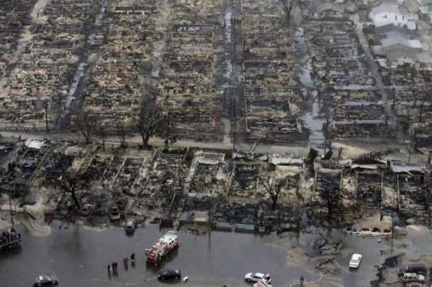
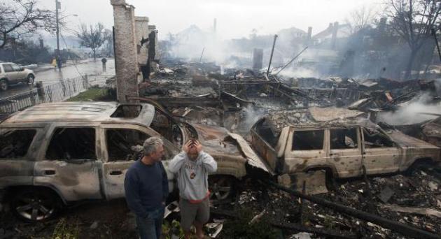
Photo credit: "Residents
look over the remains of burned homes in the Rockaways section of New
York, October 30, 2012. Hurricane Sandy battered the U.S. East Coast
last year with fierce winds and driving rain, as the monster storm shut
down transportation, shuttered businesses and left hundreds of thousands
without power." (REUTERS/Keith Bedford).
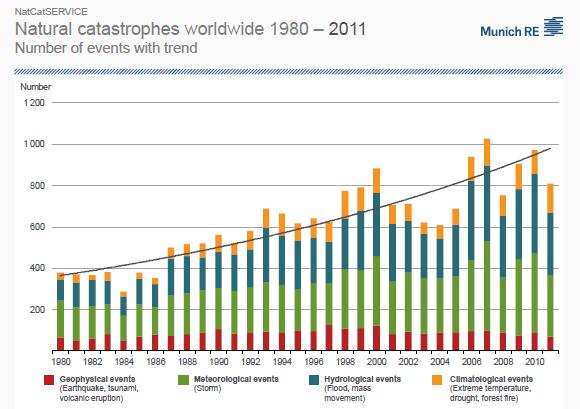
Reinsurer Tracks Natural Disasters, Tallies Devastating Effects. Here's a clip from
The Hartford Courant: "...
The
total cost of weather-related disasters in North America to insurance
companies, and to the economy overall, has trended upward between 1980
and 2011, Munich Re says. In 2012, Sandy alone cost insurers $18.7
billion — more than the total cost of all hail, thunderstorms and
tornadoes combined during the active 2011 storm season that destroyed
property from Springfield, Mass., to Joplin, Mo., according to the
Insurance Information Institute, a property-casualty research entity..."
Sandy Exposes Federal Flood Insurance To Political Pressure.
Premiums are spiking near the water, local homeowners are howling, and
now their elected representatives are feeling the heat, as reported at
The Street; here's an excerpt: "
Although
health insurance gets the headlines, it's flood insurance that's
driving people crazy, one year after Superstorm Sandy. The people who
want to rebuild face low payouts from the federal insurance pool and
huge premium hikes to replenish the same pool. All this could delay the
rebuilding process by years. The risks of floods, and the catastrophic
losses from floods, have long forced beachfront property into a special,
federal risk pool, the National Flood Insurance Program..."
Photo credit: Mike Groll, AP.
4 Reasons You Should Worry About Another Sandy.
Mother Jones has the story - here's a clip: "...
According to NASA researchers, Sandy's particular track made it a 1-in-700 year storm event.
It was, to put it mildly, meteorologically suspicious. So now, with a
year's distance and a lot of thought and debate, what can we say about
climate change and Sandy—and hurricanes in general? A lot, as it turns
out. Here's what we know:
1. Sea level rise is making hurricanes more damaging—and Sandy is just the beginning. The most direct and undeniable way that global warming worsened Sandy is through sea level rise. According to
climate researcher Ben Strauss of Climate Central, sea level in New
York harbor is 15 inches higher today than it was in 1880, and of those
15 inches, eight are due to global warming's influence (the melting of
land-based ice, and the thermal expansion of seawater as it warms). And
that matters: For every inch of sea level rise, an estimated 6,000 additional people were impacted by Sandy who wouldn't have been otherwise..."
Photo credit above: "Flooding in Breezy Point, Queens, during Sandy." Brett Brownell, Mother Jones.
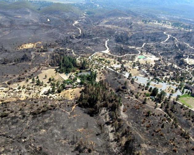
Flash Floods And Debris Flows: How To Manage Nature's Runaway Freight Trains. Here's an excerpt of an interesting follow-up on recent fires and flash floods in Colorado, courtesy of
Science Daily: "...
One
of the big science advances has been in the U.S. Geological Survey's
debris flow models. These models have helped explain, for instance,
where these potentially deadly flows are most likely to happen and how
large they might be. "We've learned that debris flows are likely from
burned area for the first two years after a wildfire." says DeGraff.
"But the chance of flash floods lasts a little longer." This kind of
information helps determine what kinds of treatments might be done to
mitigate damage..."
Photo credit above: "Private
homes along Apple Creek narrowly avoided the Mountain Fire which
occurred July 2013 in the San Jacinto Mountains between Palm Springs and
Idyllwild, California. USGS modeling in the wake of the fire has
indicated a moderate chance of a debris flow flowing down Apple Creek."
(Credit: Photo courtesy of the USDA Forest Service.)

Blizzard At The Superbowl? Businesses Seek Insurance.
What are the odds? Slim, statistically, but Old Man Winter does have a
wicked sense of humor. At this point nothing would surprise me.
CNBC has the story; here's the intro: "
Super
Bowl 2014 at New Jersey's Meadowlands is expected to bring the
Northeast $1.5 billion in revenue, but some businesses are already
worrying about the weather, The Star-Ledger reported Tuesday. After the
Farmers' Almanac said a bitter storm could hit the Northeast around the
time of the big game on Feb. 2, business owners began to look for
insurance. "It's an insurance most business owners probably don't have
now and might not be thinking about," said Lori Shaw, executive director
of the entertainment practice at Aon Risk Solutions..."
Air Pollution Sickening Computers Too. Just when you thought you had seen everything, along comes this story from AP and
The Seattle Times; here's an excerpt: "
In
a windowless lab at its Hillsboro campus, Intel scientists are brewing
foul air so they can study the effects of air pollution on the innards
of computers — a step toward figuring out how to protect electronics in
markets such as India and China that have big pollution problems and the
potential for big sales growth. So far, the scientists tell The Oregonian
newspaper, there have been no breakthroughs as they load test tubes of
pressurized hydrogen sulfide, sulfur dioxide and chlorine, and calibrate
their effects on electronics..."
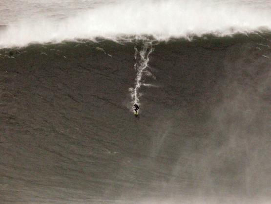
Riding "The Big One".
Good grief, a 77 foot wave? The stuff of watery nightmares. This was
off the coast of Portugal, a possible new world record for surfing the
biggest wave. Some witnesses estimated that it was more than 100 feet
high. Here's a post (and amazing video clip) from
Surfer Today: "
The Brazilian crew traveled to Portugal with a goal in mind. To beat the Guinness World Record for the largest wave ever surfed,
which belongs to the Hawaiian hellman, Garrett McNamara. Carlos Burle,
Pedro Scooby, Felipe Cesarano, and Maya Gabeira had big hopes for the
European super swell. On the 28th October, 2013, Burle claimed one of
the biggest wave ever ridden at Praia do Norte. The first pictures show
that he may be above the world record set by Garrett McNamara, at 23.77 m
(78 feet), measured from trough to crest, on the 1st November 2011..."
What Happened To Just Watching Sesame Street? From
Marketplace: "
A new study
from the group Common Sense Media found that 38 percent of children
under two have used a mobile device, like an iPhone or tablet computer.
That’s up from 10 percent just two years ago. The earliest of adopters"
TODAY: Cloudy and damp. A few showers may arrive by late afternoon or evening. Winds: E 10. High: 53
WEDNESDAY NIGHT: Periods of light rain. Low: 45
HALLOWEEN: Light showers taper early. Dry, damp evening for Trick or Treating. High: near 50
FRIDAY: More clouds than sun, cooler. Wake-up: 40. High: 46
SATURDAY: Partly sunny, less wind. Wake-up: 31. High: 46
SUNDAY: Dim sun, milder. Gusty winds. Wake-up: 30. High: 50
MONDAY: Clouds increase with late showers, not bad for November. Wake-up: 40. High: 49
TUESDAY: A cold rain spreads in. Wake-up: 36. High: 44
* rain may end as some wet snow Tuesday night into Wednesday. It's too early for specifics.
Climate Stories...
 U.S. Says It Won't Back New, International Coal-Fired Power Plants.
 The
number one thing we can do, worldwide, to reduce greenhouse gas
emissions? Phase out coal-fired power plants, convert them to natural
gas or retire them altogether. Sequestering CO2 underground (carbon
sequestration) hasn't been proven to be even remotely cost-effective.
And no, this probably won't happen anytime soon, but the market is doing
what regulation can't - relatively cheap natural gas is powering an
increasing percentage of the grid, producing roughly half the carbon
emissions. Here's an excerpt from
The New York Times: "
In an aggressive move to impose President Obama’s
environmental policies overseas, the Treasury Department on Tuesday
largely declared an end to United States support for new coal-fired
power plants around the world. The decision means that Mr. Obama’s
administration will no longer contribute to coal projects financed by
the World Bank and other international development banks..." (Photo: AP File).
Storm-Ready Cities: How Climate Resilience Boosts Metro Areas And The Economy.
The Center for American Progress has the article; here's a clip: "...
Many
city leaders—such as those in New York City, Washington, D.C., Houston,
and Miami— are developing innovative strategies to reduce the risks
from extreme weather. These leaders recognize that increasing their
cities’ resilience to climate change not only keeps people and
businesses out of harm’s way, but also—if done right—drives economic
growth and improves the quality of life in metro areas. These leaders
are working to meet priorities such as upgrading public transit and
other infrastructure, providing cleaner and more reliable energy,
creating jobs, attracting new businesses, improving air quality, and
expanding parks and green spaces. To adequately prepare our nation for
the impacts of climate change, more metro areas must follow their lead..."
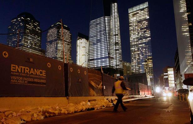
File Photo credit above: AP/Kathy Willens. "Sandbags
remain around the perimeter of the World Trade Center Memorial and
construction site after the memorial was closed by flooding in the wake
of Superstorm Sandy on Monday, November 5, 2012."
U.S. Viewpoint: Earth Dangerously Warming - And We Are Causing It. Here's an excerpt from an article at
Independent Catholic News: "...“
Human
influence has been detected in warming of the atmosphere and the ocean,
in changes in the global water cycle, in reductions in snow and ice, in
global mean sea level rise, and in changes in some climate extremes. …
It is extremely likely that human influence has been the dominant cause
of the observed warming since the mid-20th century” states the IPCC
report. In his 2010 World Day of Peace message titled 'If You Want to
Cultivate Peace, Protect Creation,' Pope Emeritus Benedict XVI boldly
wrote: “Can we remain indifferent before the problems associated with
such realities as climate change, desertification, the deterioration and
loss of productivity in vast agricultural areas, the pollution of
rivers and aquifers, the loss of biodiversity, the increase of natural
catastrophes and the deforestation of equatorial and tropical regions?”
We remain indifferent at our own risk – and that of future generations." (image above: NASA).


No comments:
Post a Comment