By Todd Nelson
WOW! What a nice stretch of weather we had last week, huh? Despite having to battle those nagging winds, we were able to make it into the 70s much of the week, bringing the average October temp to nealry 6.5F above average. Keep in mind that our average high at this time of the year is around 60F.
Naturally, weather conidtions have soured as we roll into the weekend. Our first of two fairly powerful storm systems is upon us now. Gusty west winds will usher in much colder air today, temps return to near normal levels. The second storm system quickly arrives early next week with, what appears to be, a steadier and soaking rain.
Reality check; November-like temps settle in next week as temps tumble to nearly 25F cooler than it was last week. Some may not even make it out of the 40s for daytime highs with more widespread frost and flurries possible up north by the end of the week.
Snow in October? No, it's not uncommon. MSP averages a little under 1", with the avg. first measureable snow usually arriving by October 16. Who could forget our snowiest October in 1991 with 8.2"; that was SCARY!
By the way, we "Fall back" one hour 3 weeks from tomorrow... UGH
_____________________________________________________________________
SATURDAY: Partly sunny, breezy and cooler. Lingering AM showers up north. High: 61
SATURDAY NIGHT: Mostly clear, cool and quiet. Winds lighten up. Low: 38
SUNDAY: Plenty of sun. Pleasant. Temps return to normal. High: 61
MONDAY: Clouds thicken. Steady rain develops late. Wake-up: 43. High: 56
TUESDAY: Wet. Feels like November. Wake-up: 43. High: 52
WEDNESDAY: Rain tapers, still raw. Wake-up: 42. High: 53.
THURSDAY: Another reinforcing shot of cooler air. Chilly rain showers, flurries possible up north? Wake-up: 40. High: 51.
FRIDAY: Mostly cloudy with a few showers/sprinkles. More flurries up north? Wake-up: 37. High: 49.
________________________________________________________________________
The Demise of a Comet
"Space: The final frontier
These are the voyages of the Starship, Enterprise
Its 5 year mission
To explore strange new worlds
To seek out new life and new civilizations
To boldly go where no man has gone before"
I can't help but think of those words when I see things like that below. The demise of a comet as it plunges into the sun. It happened earlier this week and was recorded by SOHO, a department of NASA. It's pretty amazing when you think about how nasty the sun can be to swallow up something like that.
"SUNDIVING COMET, R.I.P.: A comet plunged into the sun--but it did not come out again. The icy visitor from the outer solar system was blasted by solar heat and completely destroyed. SOHO recorded the doomed comet's last moments.
The comet, R.I.P., was a member of the Kreutz family. Kreutz sungrazers are fragments from the breakup of a single giant comet many centuries ago. They get their name from 19th century German astronomer Heinrich Kreutz, who studied them in detail. Several Kreutz fragments pass by the sun and disintegrate every day. Most, measuring less than a few meters across, are too small to see, but occasionally a bigger fragment like this one attracts attention."
Read more from Spaceweather.com HERE:
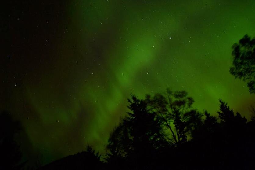
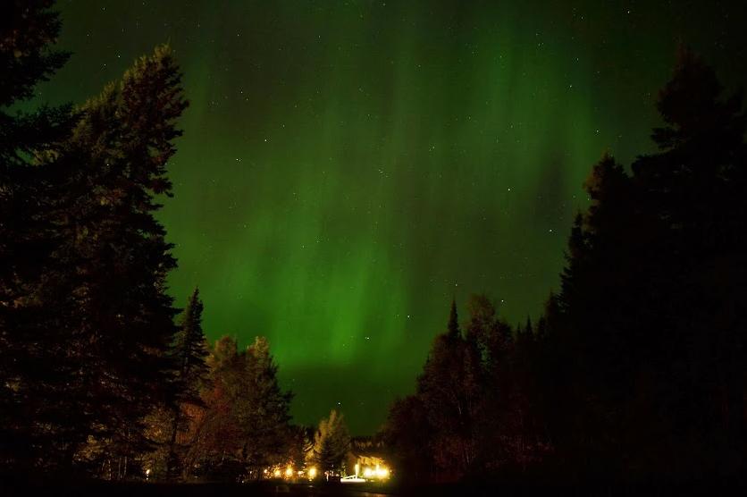
Northern Lights
Being a northern latitude dweller, I've seen my fair share of northern lights, but I've never seen them as impressive has I did at the beginning of October. I happened to be on vacation at the time and was able to capture these scenes below. I'm hoping I'll have another chance to improve my nighttime photography skills. Can anybody recommend a good book/video?
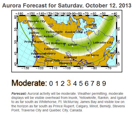
Northern Lights Forecast
This is one of my favorite bookmarks for northern light forecasts. It comes from the University of Alaska Fairbanks' Geophysical Institute. They generally forecast a few days out; it appears that there is a moderate chance of northern lights for Saturday.
See more HERE:
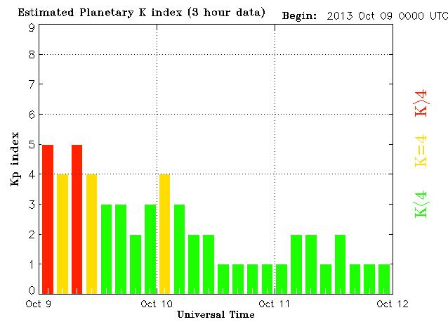
Monitoring the K-Index
Here's a site that I frequent often too, it's the K-Index, which indicates when geomagnetic storms may be in progress. Anytime the K-Index is greater than 4, it is considered active and northern lights may be visible for northern dwellers.
See more HERE:
Typhoon Phailin
Super Typhoon Phailin is a massive storm that could be equavalent to a category 5 hurricane by the time it makes landfall on the eastern shores of India by Saturday. Some are saying that this could be compared to the size and intensity of hurricane Katrina back in 2005!
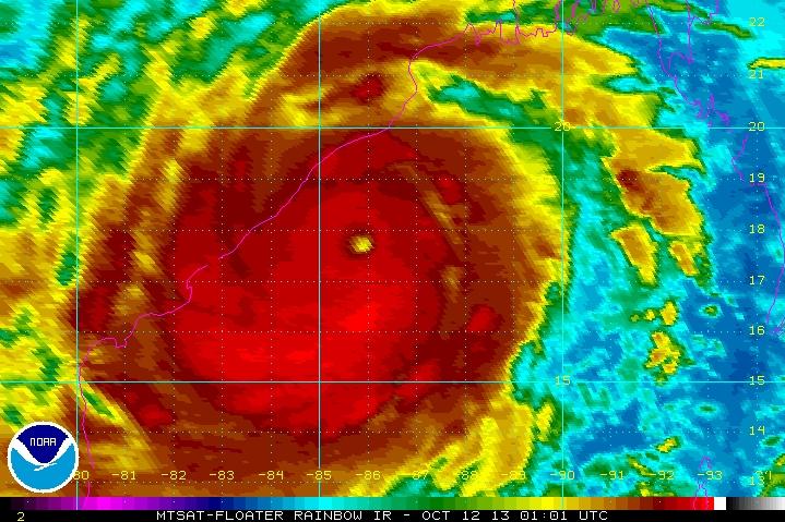
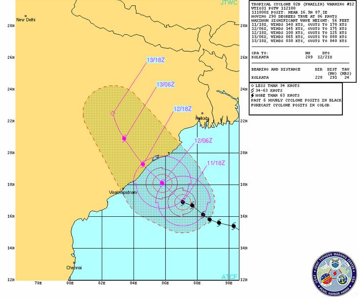
Here's the latest from the Joint Typhoon Warning Center:
More on Super Typhoon Phailin
"Rough seas forced fishing vessels to return to port Friday as Typhoon Phailin bore down on India's Bay of Bengal, officials said. Four fishermen were rescued a day after their ship capsized near the Gahirmatha and Bhitarkanika marine sanctuaries, Paradip marine fisheries officer Ranjit Keshari Dash told Press Trust of India. The fishermen had put to sea despite the typhoon warnings but Dash had no reports of any fishing vessels stranded at sea. With the potential to intensify into a super storm, Phailin was expected to make landfall Saturday evening at Gopalpur in Odisha state. More than 260,000 people were being evacuated from low-lying areas. The Joint Typhoon Warning Center Friday classified the storm as a Category 4 and said it could increase in intensity to a Category 5 by Saturday. Some forecasters compared the size and intensity of the typhoon to Hurricane Katrina, which hit the U.S. Gulf Coast and New Orleans in 2005, the Hindustan Times said."
Read more from UPI.com HERE:
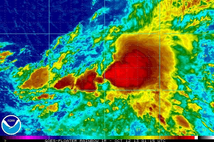
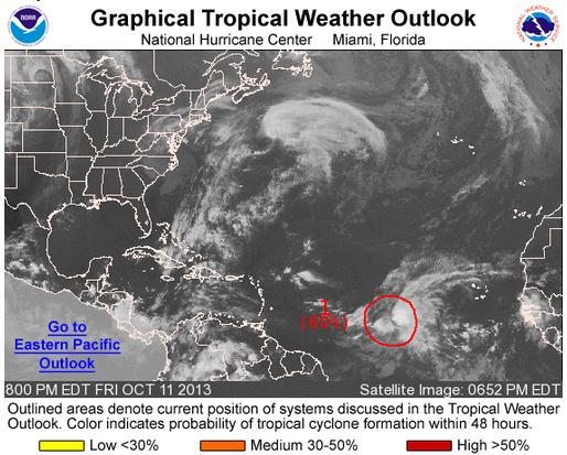
Watching the Tropics
Closer to home, the tropics may be heating up a bit closer to home as the National Hurricane Center is tracking a cluster of storms in the central Atlantic. As of PM Friday, Invest 98L had a high chance of becoming our next named storm of the 2013 season. If this does become our next tropical storm, Lorenzo would be the name.
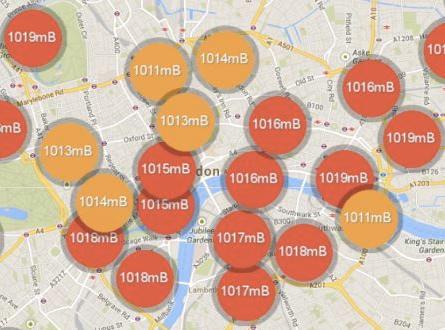
WeatherSignal
WOW! This is cool! Think of the possibilities.
"Smartphone-collected Big Data has the potential to transform the way we can understand and predict weather systems. Five months ago, we at OpenSignal (a project to map global cell phone signal coverage) launched an app called WeatherSignal to collect atmospheric data from smartphones. WeatherSignal works by repurposing the sensors that already exist in Android devices in order to build a live map of atmospheric readings. The most recent Galaxy phone, the S4, contains a barometer, hygrometer (humidity), ambient thermometer and lightmeter – all of which is important data for meteorology. While the S4 is the most advanced phone in terms of sensors, valuable readings can be gathered from many other phones as well. The prospect of a granular network of millions of inter-connected weather stations is an exciting one for meteorology."
Read the full story HERE:
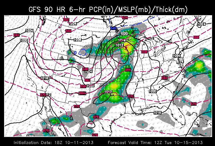
Our Next Storm
Take a look at the forecat below, which shows the GFS solution to storm #2 early next week. It's on the heels of the storm that rolled through the western two-thirds of the nation over the past several days. This one however, looks to bring more steady rain to folks in the Midwest with another shot of snow to the High Plains. There could even be a severe weather potential for folks in the central part of the country later in the week.
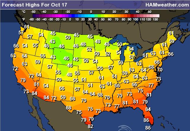
Big Changes Ahead
As mentioned above, there are some big changes in the works for the Lower 48 by late next week. A series of storms/fronts will help to bring temps to below normal levels for much of the nation. Here's a look at potential highs for late next week.

Thanks for checking in and have a great weekend ahead.
Don't forget to follow me on Twitter @TNelsonWNTV

No comments:
Post a Comment