67 F. high in the Twin Cities Monday.
62 F. average high on October 7.
53 F. high on October 7, 2012.
70s likely every day into Friday.
Showers Friday PM, steadier, heavier rain possible the latter half of next week.
Slight frost risk (mainly outer suburbs) next Wednesday morning.

"...I
think that markets will do a much cheaper, faster job of attacking our
energy and environment problems than having politicians and regulators
try to solve them by selecting technologies or drafting complex rules
and regulations that simply hide the costs from consumers and producers
alike. The likelihood that what I just said will actually happen is
vanishingly small..." - from a recent Forbes article, details below.
Above and Beyond
Here's a good ROI, return on investment. Every U.S. citizen pays $4/year to fund NOAA, the agency that provides the forecasts, severe weather warnings & raw data streams to power Doppler & weather satellites - the fuel that powers every weather forecast made in this country.
Now I'm free to interpret the data differently than another forecaster, but if NOAA went away we'd be back in the 1800s, staring up at an Amish Doppler (west-facing window).
Local Weather Service forecasters, unpaid, considered "unessential personnel", braved 4-6 foot drifts, hiking ON FOOT to get to their office and keep emergency operations going, during what was probably the worst October blizzard on record at Rapid City.
A friend measured 50" snow (without the drifts) at the High School in Lead, South Dakota!
My point: countless government employees are working through the pain of no pay and lingering uncertainty to save lives and get things done. We owe them a debt of gratitude.
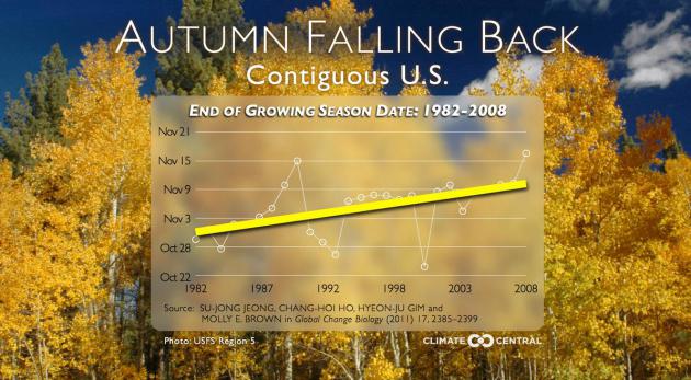
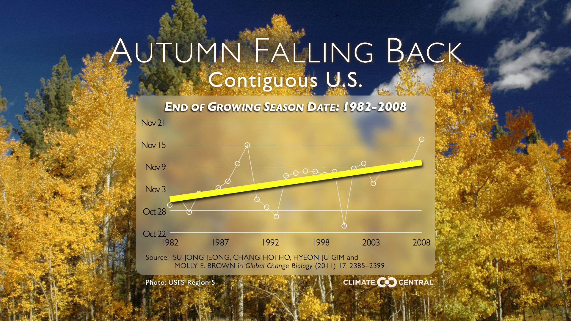
Another soul-soothing spell of 70s lingers into Friday; late-week showers ushering 50-degree highs early next week. Long-range ECMWF models hint at a suburban frost risk next Wednesday, almost 2 weeks later than average.
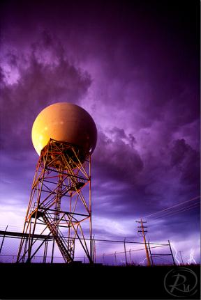
* Doppler radar photo above courtesy of Reid Wolcott.
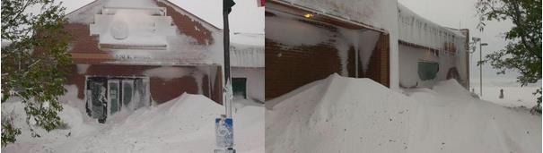
Local (unpaid) National Weather Service Heroes.
The photos above, courtesy of WeatherNation TV, show the impact of the
recent blizzard on the local National Weather Service office in Rapid
City. Meteorologists Jeff Pietrowski reported 50" of snow at the high
school in Lead, South Dakota, which is remarkable for early October (or
any month!) I received this overview of how (unpaid, "unessential")
National Weather Service employees at the Rapid, City, South Dakota
office of the NWS coped with a record weekend blizzard across western
South Dakota. This is the stuff that doesn't necessarily make national
news headlines, but maybe it should:"Access to the office is still
blocked. Two employees were able to hike in around some obstructions,
but it is not possible to drive out of the parking lot due to snow
drifts and downed trees in the neighborhood. The SOO (one who hiked in)
is attempting to take two stranded employees home this morning. One
forecaster hiked in for his mid shift last night, and I sent him home so
he can come back tonight. Of the three who are on duty at this time,
two have been here since 7 a.m. Friday, and I have been here since 3
p.m. Friday. We have two NWR transmitters down: Terry Peak and Rapid
City. We have three ASOSs down: IEN, RAP, and PHP. We are on commercial
power which has been stable since yesterday evening. Rapid City is
pretty much paralyzed, and recovery and repair operations are in full
swing. We have heard that the governor called in the National Guard.
Conference call briefing expected to take place later this morning.
There is some concern about the potential for flooding with temperatures
warming up quickly tomorrow and melting off the large snowpack. we have
1 to 4 inches of liquid equivalent on the ground and a big rain storm
in the models for Friday. 8:09 a.m. MDT"
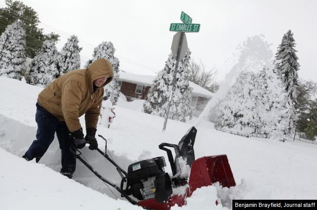
- 21.5 inches of snow fell on Friday night in Rapid City – the highest single-day snowfall for October since record keeping began around the 1890s.
- The National Weather Service has recieved reports of 43 inches of snow in Lead and 48 inches in Deadwood.
- More than 38,000 properties across the Black Hills remain without power..."
Photo credit above: Benjamin Brayfield, Rapid City Journal staff.

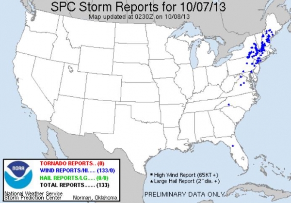
A Crazy 72 Hours Of Weather.
Roof-crushing snows in Sturgis, South Dakota last Saturday? The
extremes around the USA last weekend were pretty awe-inspiring; 90s in
Washington D.C. to EF-4 tornadoes in Nebraska, over 4 FEET of snow in
the Black Hills of South Dakota, record flooding in Louisville, while
brushfires sparked evacuations near Camp Pendleton in southern
California. More on the volatile weather in today's edition of Climate Matters: "Blizzard,
tornado outbreak, flooding and roller coaster temperatures, all in the
last weekend. Meteorologist Paul Douglas discusses the past weekend
storms and weather extremes from all around the country."
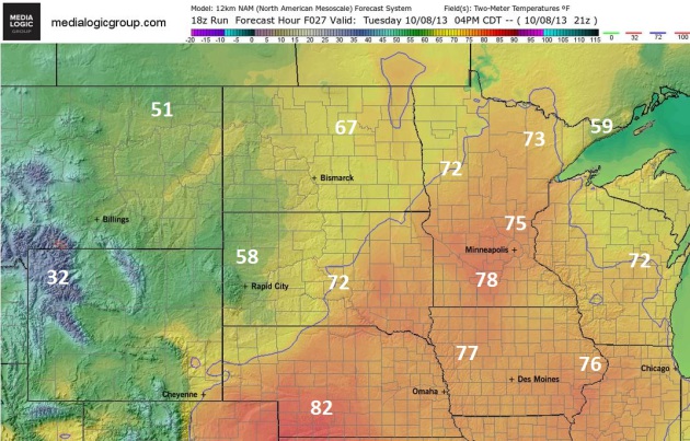
More September 8 Than October 8.
With a gusty south wind and blue sky it will feel like early September
out there by afternoon; NAM guidance showing highs in the mid, even some
upper 70s by mid afternoon, about 10-20 F warmer than average. Map:
NOAA and Ham Weather.
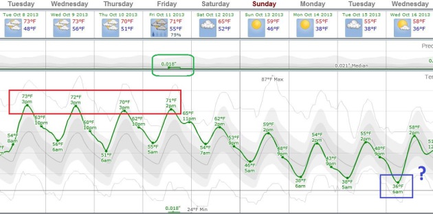
Supersized Autumn?
We'll see how long our luck holds out, but unusually mild weather
spills over into most of this week; highs topping 70 F into Friday,
based on ECMWF guidance. Showers are possible late Friday ahead of a
cooler front - highs in the 50s from Sunday into much of next week. I
could see a suburban frost by Wednesday morning of next week,
heavier/steadier rain possible by next Thursday and Friday. Graph:
Weatherspark.
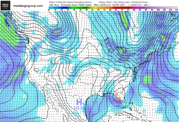
Significant Coastal Storm?
The GFS model is spinning up a nearly stationary area of low pressure
east of the Carolinas later this week into early next week; from the
soggy dregs of what was once "Karen" in the Gulf of Mexico. It almost
looks like the storm has tropical characteristics. The ECMWF is less
impressive, but also hints at a coastal storm for New England early next
week. Coastal beach erosion can't be ruled out from the Outer Banks to
Cape Cod. Meanwhile the central USA warms up into late week with Pacific
storms brushing the West Coast with high winds and heavy rain. Map
above shows predicted wind speeds and pressure, courtesy of NOAA and Ham
Weather.

* Typhoon Danas landfall likely near Nagasaki, Japan and Busan, South Korea by Tuesday afternoon (local time) as a Category 1 storm, capable of 5-10" rains and a 4-8 foot storm surge from Nagasaki to Fukuoka, Yamaguchi and Hiroshima. Busan and Ulsan, South Korea will also see major impacts later in the day Tuesday with extensive urban flooding expected.
* Flash flooding, mudslides and facility disruptions are possible along the northern coastline of Japan (mainly Kyushu and Chugoku Prefectures).
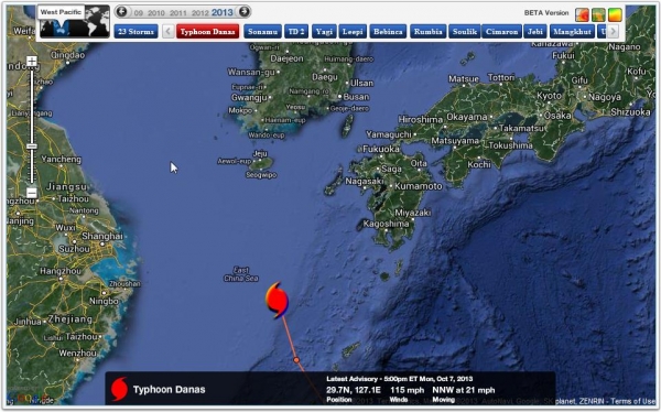

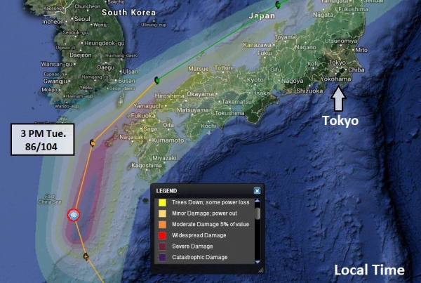
Summary: Things are quieting down in the USA, but western Japan and far southern South Korea are bracing for Typhoon Danas on Tuesday (local time). Although the storm is weakening steadily it's still capable of moderate to major storm surge and inland flooding Tuesday into Wednesday, local time. Osaka and Kyoto may see significant rains, but the core of the storm should pass north, sparing those major city center as well as Tokyo.
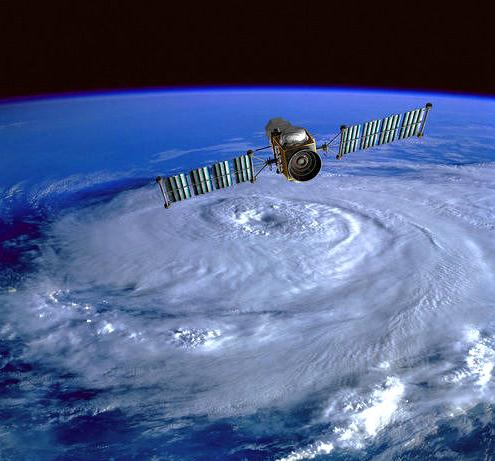
Quiet Hurricane Season Defies Predictions.
No kidding. This is why I'm highly skeptical of the long-range
hurricane "outlooks" that come out around June 1 - more of a horoscope
than an actual forecast. Here's an excerpt of a good explanation of what
happened (to diminish hurricane potential in the Atlantic) from The Post And Courier: "...Today,
Saharan dry air is a staple of hurricane forecasting. And this year,
the Saharan winds blew farther southwest than usual, right into the zone
where African monsoons blown into the Atlantic form tropical waves that
become hurricanes — the notorious Cape Verde storms. Meteorologists in
West African nations called August the driest they had ever seen, Dunion
said. At least two other things happened: The air carried dust all the
way across the Atlantic into Brazil, then into the Caribbean where it
disrupted storms there. A pocket of cooler water in the ocean off
Portugal weakened storms that moved north. Neither of the two were
factored into computer modeling for predictions..."
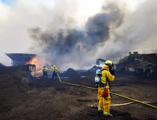
Photo credit above: "Newport Beach and Laguna Beach firefighters work to put out a mulch pile at a nursery near Santiago Canyon in Orange County, Calif. Sunday, Oct. 6, 2013. The blaze, reported late Sunday morning, quickly spread to surrounding wild vegetation, said Orange County Fire Authority Capt. Steve Concialdi. No homes were threatened." (AP Photo/The Orange County Register, Stuart Palley).


5 Quotes About The Debt Ceiling That Will Totally Freak You Out. Yes, I'm freaked. Our politicians in D.C. need adult supervision. Here's an excerpt from a story at The Week: "Prepare for a "financial apocalypse," says Yalman Onaran at Bloomberg.
Failure by the world's largest borrower to pay its debt — unprecedented in modern history — will devastate stock markets from Brazil
to Zurich, halt a $5 trillion lending mechanism for investors who rely
on Treasuries, blow up borrowing costs for billions of people and
companies, ravage the dollar and throw the U.S. and world economies into
a recession that probably would become a depression. Among the dozens
of money managers, economists, bankers, traders, and former government
officials interviewed for this story, few view a U.S. default as
anything but a financial apocalypse. [Bloomberg]"

Dogs Are People, Too. My dog certainly thinks so, and this excerpt of a recent New York Times Op-Ed seems to verify that theory: "...The
ability to experience positive emotions, like love and attachment,
would mean that dogs have a level of sentience comparable to that of a
human child. And this ability suggests a rethinking of how we treat
dogs. DOGS have long been considered property. Though the Animal Welfare
Act of 1966 and state laws raised the bar for the treatment of animals,
they solidified the view that animals are things — objects that can be
disposed of as long as reasonable care is taken to minimize their
suffering. But now, by using the M.R.I. to push away the limitations of
behaviorism, we can no longer hide from the evidence. Dogs, and probably
many other animals (especially our closest primate relatives), seem to
have emotions just like us. And this means we must reconsider their
treatment as property..."

TODAY: Sunny, windy & warm. Winds: South 15-30. High: 78
TUESDAY NIGHT: Clear and dry. Low: 55
WEDNESDAY: Lukewarm sun, still pleasant. High: 76
THURSDAY: Partly sunny, feels like September. Wake-up: 52. High: 73
FRIDAY: Fading sun, PM showers likely. Wake-up: 56. High: 71
SATURDAY: Partly sunny, drying out. Wake-up: 53. High: 64
SUNDAY: Intervals of sun, feels like fall. Wake-up: 50. High: 58
MONDAY: Mix of clouds & sun, cool. Wake-up: 45. High: 56
* slight risk of a suburban frost by Wednesday of next week.
** photo above: Mike Hall.
Climate Stories....


No comments:
Post a Comment