61 F. high in the Twin Cities Thursday.
64 F. average high on October 3.
78 F. high on October 3, 2012.
.90" rain from current storm as of 7 pm Thursday.
.97" additional rain predicted by Sunday.
Moderate severe storm risk far southern Minnesota later today.
Keeping The Lights On
People
are still buzzing about Tuesday night's vivid display of the Northern
Lights. Aurora are triggered by massive storms on the sun, solar flares
lighting up the nighttime sky. But they can also disrupt satellite
communications, GPS, even bring down portions of the power grid.
We're
at the peak of the 11 year solar cycle. During any decade there's a 12
percent risk of a major X-class flare capable of disrupting power.
The
Energy Information Administration shows a 10-fold increase in
weather-related power outages since 1992; severe T-storms, derechos,
high winds and intense hurricanes make keeping the lights on non-trival
at times.
SPC has a moderate risk of severe storms over southern
Minnesota today - a few isolated tornadoes can't be ruled out. Yes,
unusual for October. More rain (and a few strong storms) are likely
today. Showery rains extend into Sunday as the storm track shifts 100
miles farther east. That could mean a raw, soggy race for the Twin
Cities Marathon with highs in the 40s.
It could be worse. The Black Hills could pick up a foot of snow by Saturday.
Have a nice day!
ECMWF guidance shows 4 days above 70F next week. That will be a nice change of pace.
* Photo above: Jim Calaway, taken near Green Bay, Wisconsin Tuesday night.
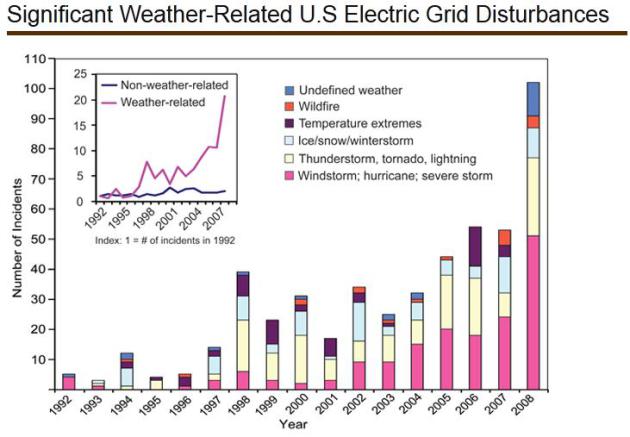
Increasingly Vulnerable:
the number of incidents caused by extreme weather has increased 10-fold
since 1992. Weather-related events are more severe, with an average of
180,000 customers affected per event.
Source: Energy Information Administration, U.S. Global Change Research Program.
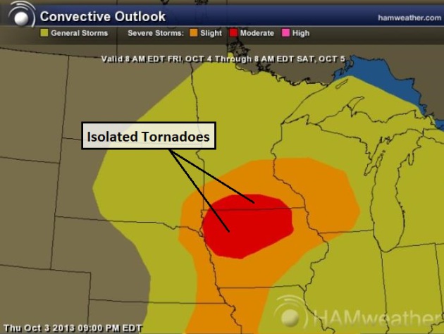
Moderate Severe Storm Risk.
SPC has southern Minnesota and much of Iowa in a "moderate" risk, which
is often a trip-wire for storm chasers, a way of saying "watch for
large, violent tornadoes". I expect a few supercell T-storms to bubble
up along a vigorous warm frontal boundary near the Iowa border by
afternoon. Stay alert for watches and warnings, especially south of the
Twin Cities. Map: NOAA and Ham Weather.
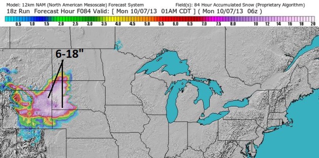
Crippling Snowfall?
Our internal models are printing out some 10-20" of snow for the Black
Hills of South Dakota, west of Rapid City into much of Wyoming and the
Panhandle of Nebraska. Yeah - this is sort of sudden, considering highs
were close to 90F over much of South Dakota Monday.
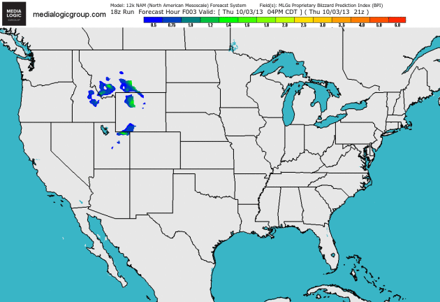
Blizzard Potential Index.
The BPI is another internal model we look at when calculating the odds
of low visibility from falling/blowing snow. You can see a significant
risk of blizzard conditions spreading out of Wyoming into the western
half of South Dakota later today into early Saturday. Loop: Ham Weather.
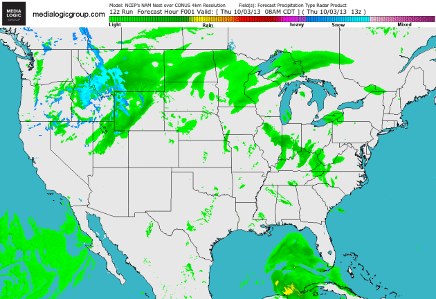
Tracking Two Major Storms.
You can see how small Karen is (sorry Karen) compared to the cyclone
impacting the Rockies, Plains and Midwest, which will see more rain and
strong/severe T-storms today. The blue smear is snow, heavy at times
from the northern Rockies into the western Dakotas. Map: Ham Weather.
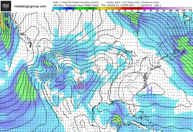
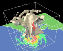
GFS Simulation.
The animation above shows sustained wind speeds (10 meters) and surface
pressures looking out into early next week. A powerful pressure
gradient whips up 40-50 mph winds over the western Dakotas, increasing
the risk of blizzard conditions near Rapid City. Meanwhile Karen comes
ashore by Saturday night (farther east than other models - closer to
Panama City). A strong contrast in pressure also whips up 40-60 mph
(Santa Ana) winds over southern California, enhancing the risk of
fast-moving wildfires. Animation: Ham Weather.
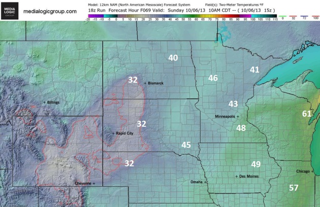
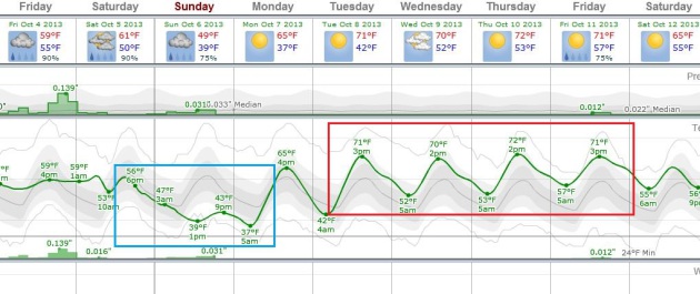
A Raw, Soggy Medtronic Twin Cities Marathon.
The Ham Weather (NAM model) map above shows expected air temperatures
at 10 am Sunday morning; readings holding in the 40s across much of
Minnesota with a few wind-whipped showers. Perfect weather to run 26.2
miles. At least you won't overhead.
Reason To Go On Living.
After a chilly weekend (50s Saturday, maybe 40s most of Sunday)
temperatures mellow again next week; ECMWF (European) guidance showing 4
days above 70F next week.
Alerts Broadcaster Update: Here's an excerpt of an
Alerts Broadcaster Briefing issued to our corporate clients late Thursday night:
* Overnight sustained winds at 65 mph with Tropical Storm Karen; holding fairly steady since Thursday afternoon.
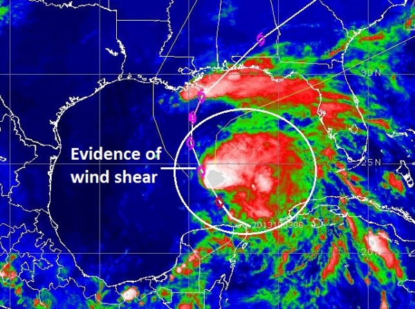
* Evidence of wind shear impacting Karen's circulation - will probably limit how intense this storm will become before landfall.
*
Karen may still strengthen into a Category 1 hurricane later today; but
some weakening is likely before Karen comes ashore late Saturday.
*
Moderate storm surge and inland flooding and minor wind damage is
expected within a 100-150 mile cone, straddling where Karen comes
ashore. Full readiness is called for, but this will not be a Sandy or
Katrina-scale storm.
Winds Aloft Putting A Brake On Karen's Strengthening.
As predicted Thursday, Karen is moving into a more sheared environment,
with stronger winds aloft shredding the storm's circulation, pushing
most of the convection into the east and northeast quadrant of the
storm. Although some strengthening is possible later today, the farther
north and northeast Karen travels the greater the expected wind shear,
and I agree with NOAA NHC's assessment that Karen will impact the Gulf
Coast as a strong tropical storm or weak Category 1 hurricane:
KAREN CONTINUES TO BE A SHEARED CYCLONE WITH A VIGOROUS
CIRCULATION...AND WITH MOST OF THE THUNDERSTORM ACTIVITY TO THE
NORTH AND EAST OF THE CENTER. THERE HAS BEEN AN EXCELLENT COVERAGE
BY BOTH AIR FORCE AND NOAA HURRICANE HUNTER PLANES DURING THE PAST
SEVERAL HOURS. BASED ON THAT RECONNAISSANCE DATA...THE INITIAL
INTENSITY IS KEPT AT 55 KNOTS IN THIS ADVISORY. THE SHEAR AFFECTING
KAREN IS FORECAST TO INCREASE AND THIS WOULD SUGGEST WEAKENING. IT
IS BECOMING LESS REALISTIC THAT KAREN WILL BECOME A HURRICANE IN A
DAY OR TWO...BUT GIVING CREDIT TO SOME DYNAMICAL MODELS...LIKE THE
HWRF...WHICH DO SO...THE NHC FORECAST CALLS FOR A SLIGHT
STRENGTHENING. IT IS ANTICIPATED THAT KAREN WILL BE ON A WEAKENING
TREND BEYOND 48 HOURS...AND BECOME EXTRATROPICAL BY DAY 4.
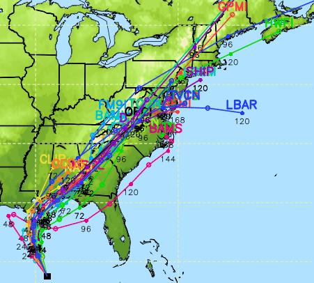
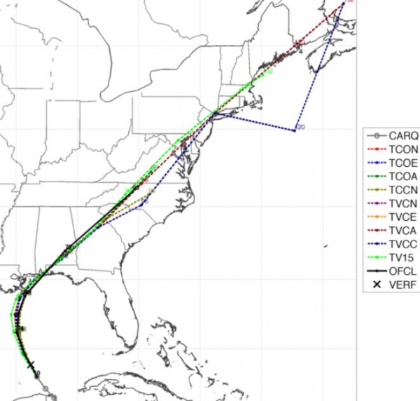
Track Ensemble.
There's an increasingly tight grouping of model solutions, showing
probable landfall late Saturday night between Mobile and Fort Walton
Beach, with Pensacola close to the centerpoint of the risk-fan. The
soggy dregs of Karen will accelerate to the northeast after landfall
Sunday, enhancing rains from the Appalachians into the Mid Atlantic
region, where flash flooding can't be ruled out. The storm will be
progressive (ie moving at a strong clip), reducing the risk of extreme
rainfall amounts and historic flooding.
Consensus Model Track.
Right now it would appear that Karen will clip the mouth of the
Mississippi (producing a potentially significant storm surge just east
of New Orleans, in Chandeleur Sound and Lake Borgne. If this track
verifies the barrier islands of Pensacola Beach and Fort Walton
Beach/Destin will see a significant surge, which is always worse to the
east (right) of the projected storm track.
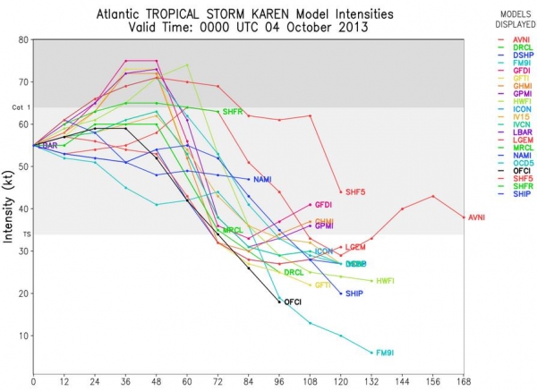
Intensity Predictions.
A number of models, including NOAA's HWRF simulation, strengthen Karen
to Category 1 hurricane force later today into Friday night, but all
models show rapid weakening by Saturday afternoon/evening as the storm
approaches land, interacting with increasing wind shear.
I still believe Karen will hit the Gulf Coast as a strong tropical storm or weak Category 1 hurricane within 48 hours.
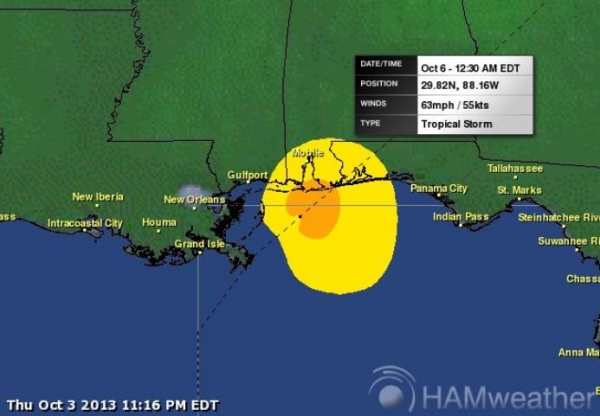
Landfall Prediction.
Our in-house models show a preliminary landfall at 12:30 AM EDT Sunday
morning between Mobile and Pensacola, with sustained winds of 63 mph and
gusts to hurricane force. I'm most concerned about barrier islands,
including Gulf Shore, Gulf Breeze, Navarre and Fort Walton Beach/Destin.
Areas within 2-4 feet of sea level may experience significant storm
surge flooding, coinciding with high tide around midnight Saturday
night.
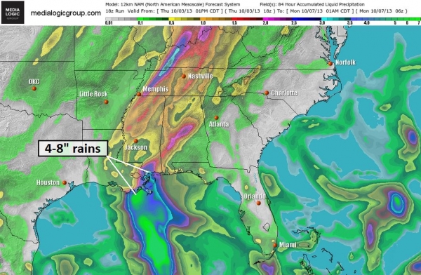
Excessive Rains.
Models still suggest some 4-8" rains from near New Orleans to
Pensacola; the worst of the storm comes from midday Saturday into Sunday
morning, with rapid improvement by Monday. Urban areas and small
streams that normally flood will probably see flood-related problems
over the weekend.
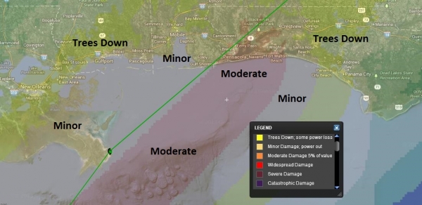
Karen's Predicted Damage Swath.
Right now we don't expect severe or catastrophic (wind) damage from
Karen, but moderate wind damage (downed trees and powerlines, some
damage to roof tiles and windows) is expected near Pensacola late
Saturday and Saturday night.
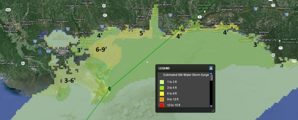
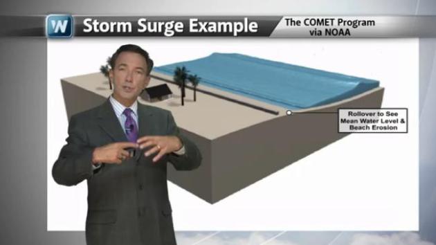
Storm Surge.
A combination of sustained winds, low pressure and the slope of
offshore terrain will create a dome of water that comes ashore just
ahead of the storm center late Saturday and Saturday night, magnified by
astronomical forcing (high tide). Chandeleur Sound east of New Orleans
may see a surge in excess of 5-6', with a 3' surge pushing into Lake
Borgne. A 3-4' storm surge is anticipated from Biloxi and Pascagoula to
the barrier islands just south of Pensacola, on east to Destin, Seaside,
and Santa Rosa. Mobile Bay may experience a 2-3 foot storm surge, with
the peak of the rising tides coming Saturday night.
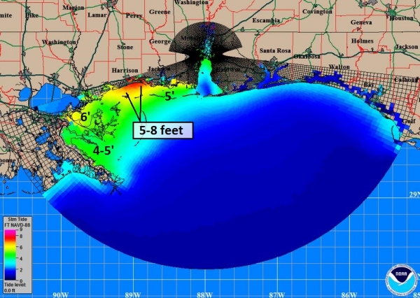
Slosh Model.
Although not operational, we have access to NOAA's slosh models for
individual metro areas, confirming a significant surge potential east of
New Orleans into coastal Harrison and Jackson counties. A 2-4' surge is
possible in Mobile Bay, a lesser surge farther east into the Panhandle
of Florida. These numbers will change as the forecast track/intensity
crystalizes before landfall late Saturday night.
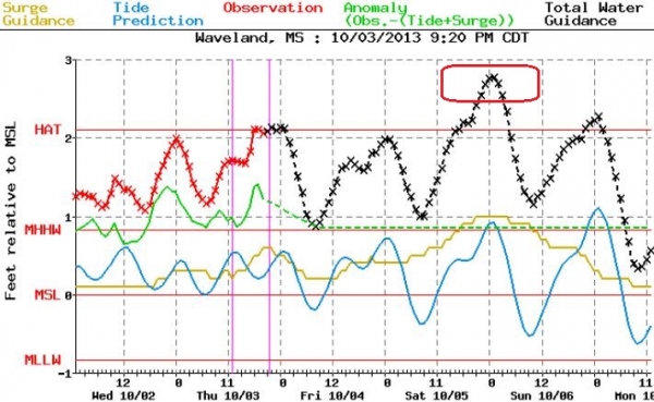
Sample Surge Report.
Peak storm surge at the aptly named Waveland, Mississippi is forecast
for midnight Saturday night, roughly 3 feet above mean sea level.
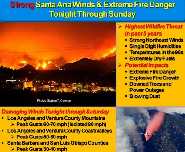
Critical Fire Risk Southern California.
High Wind Warnings and Red Flag Warnings are posted for southern
California, where Santa Ana winds may blow as high as 50-60 mph today
and Saturday. The risk: if any wildfires get started they will spread
very quickly and erratically. In addition, high winds may bring down
tree limbs, sparking sporadic power outages. Blowing dust may
temporarily obscure visibilities, impacting travel on land and in the
air. We'll be watching for significant fires breaking out in the coming
days near Los Angeles and San Diego.
Summary:
Tropical Storm Karen needs to be monitored carefully. It's the first
real storm of a very quiet hurricane season in the Atlantic, so
expectations (and fears) are high. Karen is a relatively small storm,
and wind shear will be a factor over the next 48 hours as the storm
pushes north, then northeast across the Gulf of Mexico, ultimately
limiting how strong this storm will be at landfall Saturday night. We
have to assume Karen will become a weak Category 1 storm, smaller in
scope and intensity than Sandy last October, but still capable of a
significant punch as it comes ashore. Staff and facilities along the
Gulf Coast from New Orleans to Panama City should remain on a heightened
state of alert. The risks include elevated (2-5 foot) storm surges,
moderate wind damage and power outages, and 4-8" rains capable of
significant flash flooding. Downplaying T.S. Karen would be a mistake,
but this storm isn't in the same league as Katrina in 2005.
In
addition, we're monitoring an elevated tornado risk for Iowa and
southern Minnesota, near-blizzard conditions pushing into western
Nebraska and South Dakota, and a high fire risk for southern California.
That's quite enough for one briefing. We'll keep you posted.
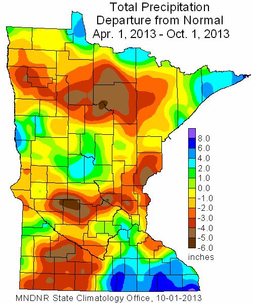
September Climate Impact. Here are a few excerpt from the Minnesota DNR's
"HydroClim" summary for September
- September
rainfall totals were below historical averages in many Minnesota
counties, especially in northeast and far southern sections of the
state. Precipitation totals fell short of long-term averages by two or
more inches in these areas.
- Across much of the southern
three-quarters of Minnesota, rainfall totals from late June to early
October were four to eight inches below normal. These rainfall deficits,
along with very hot late-summer temperatures, reestablished drought
conditions across much of the state.
Tracking Karen - How Storm Surges Form. In today's edition of
Climate Matters
we examine wind shear and less than favorable conditions over the Gulf
of Mexico for "Karen" to strengthen considerably. This storm may still
become a minimal Category 1 hurricane, but as it moves into a more
sheared environment some weakening is expected before landfall Saturday
night. How do storm surges form and why are they still a hurricane's
biggest killer? Details in today's 2:30 video segment.
What If NOAA Were Completely Shut Down?
I shudder to consider that possibility. NOAA provides the fuel, the
data, the model guidance we need as meteorologists to interpret the
weather and look out into the future with any level of confidence.
Without NOAA we would all be using Amish Doppler (ie: staring out the
nearest window). Matt Daniel makes some very good points in a post at
earthsky.org; here's an excerpt: "...
So
you think a government shutdown – even a more thorough shutdown that
included all of NOAA – could not affect you? Think again. A United
States without NOAA would be devastating to the U.S. economy. Jobs would
be lost until the government shutdown was lifted. Lives and property
would be extremely vulnerable, especially along the eastern U.S. coast
as hurricane season continues. Bottom line: The U.S. government shutdown
has halted all NASA activities. What if it halted all of NOAA, too,
instead of only about 55% of it, as now? The effects would be tremendous
and very negative for all of us. We need NOAA."
 National Hurricane Center (NHC) Spokesman On Furlough
.
Remember meteorologist Dennis Feltgen, who worked at KSTP and KARE-11?
He's a friend, and he's temporarily out of work due to the government
shut-down. Great timing, huh? Details from
NBC Miami.
Deadly Lake Turns Animals Into Statues. In News of the Weird, check out this excerpt of an eye-opening article at
New Scientist. Remind me to keep my distance from this otherwise inviting body of water - good grief: "...
The
lake takes its name from natron, a naturally occurring compound made
mainly of sodium carbonate, with a bit of baking soda (sodium
bicarbonate) thrown in. Here, this has come from volcanic ash,
accumulated from the Great Rift valley. Animals that become immersed in
the water die and are calcified..."
Photo credit:
Nick Brandt
Man Kayaks In Drainage Ditch Going 34 mph. Don't try this at home. Here's what they do for fun in British Columbia, Canada - courtesy of
kxan.com: "
LIONS
BAY, British Columbia (KXAN) - One man speeds things up substantially
by rocketing down a drainage ditch going 34 mph -- in a kayak."
TODAY: Periods of rain, strong T-storms. Severe risk southern MN. Winds: E 15. High: near 70
FRIDAY NIGHT: More showers, possible thunder. Low: 54
SATURDAY: Showers taper, skies may brighten by afternoon. Cooler. High: 55
SUNDAY: Cold & raw, showery rains return. Wake-up: 42. High: 49
MONDAY: Chilly start - mild finish. Sunny and pleasant. Wake-up: 38. High: 65
TUESDAY: Warm sun, distractingly nice. Wake-up: 42. High: 72
WEDNESDAY: Sunny, feels like September. Wake-up: 51. High: 74
THURSDAY: Partly sunny, still balmy. Wake-up: 53. High: 75
Climate Stories....
"Men argue; nature acts." Voltaire, 1769.
Preparing Minnesota for Climate Change: A Conference on Climate Adaptation.
This daylong event is being held Thursday, November 7, 2013 9 am - 5:30
pm, followed by a reception at The Science Museum of Minnesota in St.
Paul. This is the first annual gathering of local and state experts
covering a diverse range of topics related to climate mitigation and
adaptation in Minnesota, and some tickets are still available. I'll be
there; if you're personally interested in this topic, or have an
interest in possible impacts on your business or public sector duties in
the years ahead you should plan on attending. Here's a good overview
from the organizer of the event, Dr. Mark Seeley: "
The first ever
statewide conference on climate change adaptation practices will take
place at the Science Museum in downtown St Paul on November 7, 2013 from
9:00 am to 5:30 pm. The cost for the conference is modest at $60 and
includes lunch, breaks, parking, and a free pass to the Science Museum.
This conference which is titled “Preparing Minnesota for Climate Change:
A Conference on Climate Adaptation” has been designed by those who have
been measuring and documenting the changing climate attributes in the
state and their associated consequences. Professionals who have worked
in transportation, agriculture, energy, health care, city planning,
watershed and forest management, and the insurance industry will share
their stories and experiences relative to adapting to our changing
climate. The educational sessions will be followed by an evening
reception in the Science Museum cafeteria at 5:30 pm so that informal
socializing and networking among citizens and groups can occur." If interested in attending you can visit the web site for the conference at
www.wrc.umn.edu
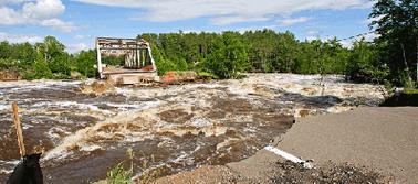
Photo credit above: "
June 2012's torrential rains devastated landscapes and wiped out the Highway 210 approach to the Thomson Bridge in Jay Cooke State Park, ten miles southwest of Duluth." Photo credit: Minnesota Department of Transportation.
Oceans Face "Deadly Trio" Of Threats, Study Says.
Reuters has the story - here's the introduction: "
The
world's oceans are under greater threat than previously believed from a
"deadly trio" of global warming, declining oxygen levels and
acidification, an international study said on Thursday. The oceans have continued to warm, pushing many commercial fish stocks
towards the poles and raising the risk of extinction for some marine
species, despite a slower pace of temperature rises in the atmosphere
this century, it said..."
Ocean Acidification Due To Carbon Emissions Is At Highest Level In 300 Million Years.
The Guardian has the story - here's a clip: "
The oceans
are more acidic now than they have been for at least 300m years, due to
carbon dioxide emissions from burning fossil fuels, and a mass
extinction of key species may already be almost inevitable as a result,
leading marine scientists warned on Thursday. An international audit of
the health of the oceans has found that overfishing and pollution are
also contributing to the crisis, in a deadly combination of destructive
forces that are imperilling marine life,
on which billions of people depend for their nutrition and livelihood.
In the starkest warning yet of the threat to ocean health, the International Programme on the State of the Ocean (IPSO) said: "This [acidification] is unprecedented in the Earth's known history..."
Photo credit above: "
Coral is particularly at risk from acidification and rising sea temperatures." Photograph: Paul Jarrett/PA.
Global Warming And Heat Waves - Our Bodies Working To Stay Cool. Here's an excerpt from a story by St. Thomas climate scientist (and good friend) John Abraham writing for
The Guardian: "...
Suffice
it to say, increases in extreme heat, which includes both daytime and
nighttime temperature levels, will pose challenges to our cities and
infrastructure. Our bodies can usually handle short durations of high
temperatures but with extended heat that lasts days or weeks with no
nighttime relief, it can become too much to bear. For persons exposed to
elevated temperatures, reactions can range from the mild (such as heat
cramps which is often effectively treated by rehydration) to more
serious conditions such as heat exhaustion which lead to reductions of
blood flow to the body's extremities and may be accompanied with
symptoms of dizziness, nausea, and low blood pressure, among others.
People who exhibit these symptoms should be moved to a cool location and
provided electrolyte rehydration..."
September Hottest On Record. Australia is on track to experience the warmest calendar year on record. Here's an excerpt from
sbs.com: "
If
the first month of spring had you sweating like it was summer, you
probably weren't alone. September was the hottest spring opener on
record, with the national average temperature a sizzling 2.75 C above
usual. Not only that but the gap between the normal temperature in
September and that recorded by the Bureau of Meteorology (BoM) was the
biggest ever observed for any month. The sweltering September was yet
another climate record to tumble this year, with Australians this year
already enduring the hottest January, hottest summer and hottest single
day ever..."


No comments:
Post a Comment