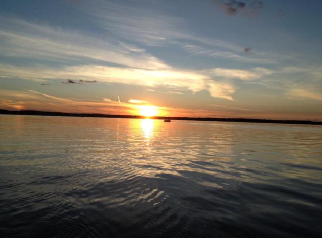
47 F. high in the Twin Cities Tuesday.
39 F. average high on November 19.
59 F. high on November 19, 2012.
Minnesota Weather History on November 19 (from the Twin Cities National Weather Service)
2006:
Lake effect snow occurred on the larger lakes in Minnesota. Northwest
winds from 8 to 12 mph accompanied an air mass in the single digits.
This moved over lakes with water temperatures near 40 degrees. A cloud
plume from Mille Lacs stretched all the way Siren Wisconsin. Snow from
Ottertail and Lake Lida reduced visibilities at Alexandia to a few
miles. Even some low clouds formed from Lake Minnetonka and were
observed at Flying Cloud Airport.
1996:
Heavy snowfall accumulations of four to eight inches occurred over much
of Central Minnesota. Some of the heavier amounts included 8 inches at
Montevideo and Gaylord, 7 inches at St. James, Mankato, Madison and
Stewart. Six inches was reported in the Twin Cities and Glenwood.
1953: Freezing rain hits parts of Minnesota. 3 inches of ice on wires at telephone wires at Lake Benton
 Thanksgiving Daze
Cranky
uncle Earl is counting down the days until Thanksgiving. Every family
has an uncle Earl. He's the one who breaks the remote control, makes
vaguely inappropriate comments at the dinner table, and doesn't have the
good sense to know when to go home. I pray he's not reading.
Family
drama is one thing, but will the weather cooperate? Probably.
Thanksgiving weather can be all over the map: 60F or knee-deep snow
drifts. Last year we had a high of 60F with a coating of snow at night.
Statistically we're more likely to subzero lows than 50-degree highs.
We've only seen 11 Thanksgiving Days above 50F in the last 141 years.
It's been as cold as -18F (1880); the last subzero low was 1985 (-8F).
Historically 1 in 3 Thanksgivings have at least 1 inch of snow on the
ground.
Enjoy upper 40s today because we're about to enjoy a few
glancing blows of arctic air. No extended periods of numbing pain, but
cold enough to get your attention. Expect weekend highs in the 20s with a
windchill near zero at times.
A Pacific breeze means highs in the
30s to near 40F on Thanksgiving. No big storms are brewing nearby, but a
light, greasy coating of snow may arrive late tomorrow. Updates on the
blog.
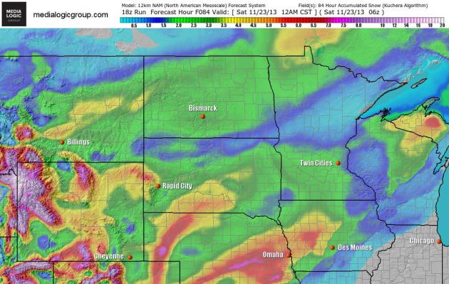
Thursday Night Snowfall?
It doesn't look like a major pile of white, but some 1-2" amounts are
possible around the Twin Cities as (much) colder air pushes into
Minnesota, the best chance of some light, accumulating snow after the
dinner hour tomorrow. Map: NOAA and Ham Weather.
A Wintry Swipe.
It won't stay bitter for long, but by Saturday there should be no doubt
in your mind that we're sliding into winter. After highs in the upper
40s today temperatures drop off tomorrow and Friday, possibly holding in
the teens to near 20F Saturday in spite of sunshine. Highs return to
the 30s much of next week, odds favor 30s for Thanksgiving Day.
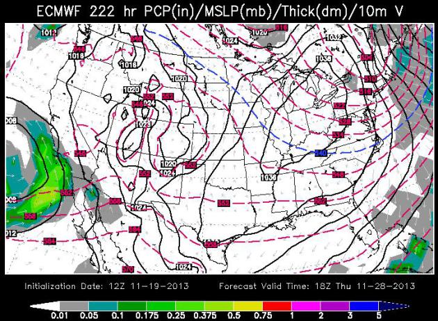
Thanksgiving Day Weather Map.
ECMWF data via WSI shows a mostly storm-free USA next Thursday,
bitterly cold air pushing across New England; colder than average for
the eastern half of America. Southern California may see some light to
moderate rain, otherwise a dry sky prevails across much of the nation.
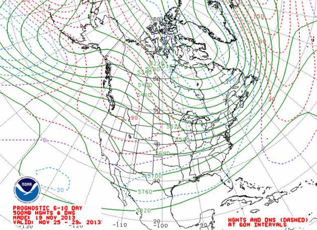
More Pacific Than Yukon.
500 mb (18,000 foot) steering winds aloft are forecast to blow from the
west-northwest between November 25-29, meaning glancing blows of cold
air from the Upper Midwest to New England, but milder than normal
conditions over the western half of the USA much of next week. Map:
NOAA.
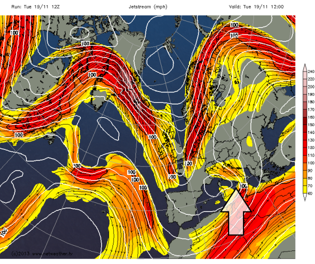
A November Tornado Outbreak For The Record Books.
Meteorologist Jason Samenow has some timely details on Sunday's
head-shaking outbreak of violent tornadoes at The Washington Post's
Capital Weather Gang; here's a clip: "...
Sunday’s
outbreak should rank among the three biggest of 2013. Although the
total number of tornadoes this year is well below average, the number of
violent tornadoes (EF-4 or higher) is above average, with 9 total,
compared to the 30-year average of 7.7.
The cause
A
very strong cold front sliced across the central and eastern U.S.,
clashing with warm, mild air out ahead of it. A strengthening area of
low pressure along the front, helped to generate large amounts of low
level spin. At high altitudes, an extremely powerful jet stream –
roaring along at around 140 mph – energized the storm system..."
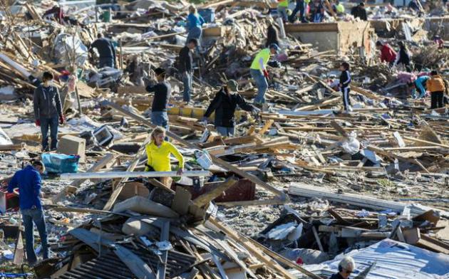
Photo credit above: "
Homeowners
and helpers dig out what they can from a mountain of debris in
Washington, Ill., Tuesday, Nov. 19, 2013 after more than 1,000 homes
were devastated by an F4 tornado that passed through Sunday. The twister
was the most powerful to hit Illinois since 1885 with wind speeds
greater than 200 mph." (AP Photo/Journal Star, Fred Zwicky)
Tornado Forecasts, Alerts Credited For Low Death Toll In Midwest.
The Spokesman has an interesting story; here's the intro: "
When
a cluster of violent thunderstorms began marching across the Midwest,
forecasters were able to draw a bright line on a map showing where the
worst of the weather would go. Their uncannily accurate predictions –
combined with television and radio warnings, text message alerts and
storm sirens – almost certainly saved lives as rare late-season
tornadoes dropped out of a dark autumn sky. Although the storms howled
through 12 states and flattened entire neighborhoods within a matter of
minutes, the number of dead stood at just eight..."
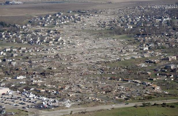
Photo credit above: Associated Press photo. "
This aerial view on Monday shows the path of a tornado that hit the Illinois town of Washington on Sunday."
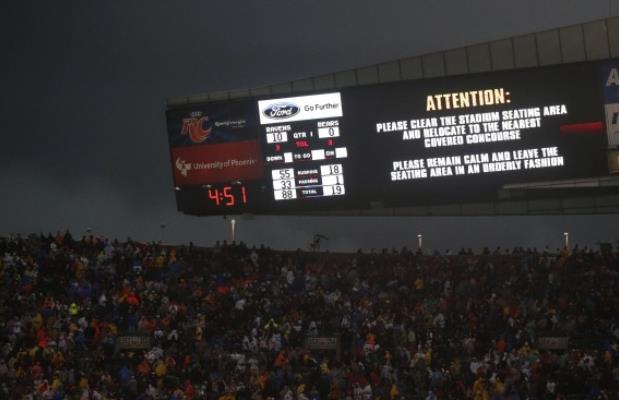
Storm Surge: Amid Questions About Delay In Chicago, NFL Maintains Stance To Put Fans First. Severe storms, lightning and tornadoes are routine summer risks for baseball games, but football?
The Washington Post has a good look at the issues NFL officials had to grapple with in Chicago on Sunday, meteorological and financial: "...
Instead,
many wondered why Sunday’s NFL game kicked off at its scheduled noon
start time, with the threat of lightning, high winds and a torrential
downpour bearing down on the city’s lakefront stadium. “Hindsight being
20-20, it’s easy to say they should have waited,” said Steve Woltmann, a
freelance photographer who has covered games at Soldier Field for
nearly three decades. “And honestly, I got a few texts from home long
before kickoff warning some crazy stuff was headed right at us..."
Photo credit above: Charles Rex Arbogast/Associated Press. "
Fans
are warned to take cover as a severe storm moves through Soldier Field
during the first half of an NFL football game between the Chicago Bears
and Baltimore Ravens, Sunday, Nov. 17, 2013, in Chicago."
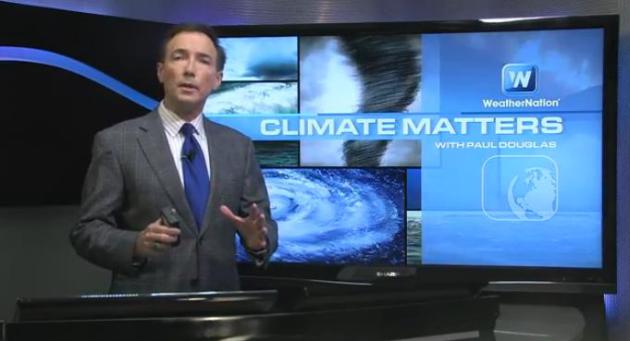
The Critical Importance Of Situational Awareness.
I tell people not to put their safety or the safety of their families
into the hands of of others when it comes to severe weather. Take the
time and the personal responsibility to monitor the weather yourself,
with that nifty computer in your pocket or purse, your smart phone. Some
of the lessons of Sunday's tornado outbreak and near-miss in Chicago at
Climate Matters: "
WeatherNationTV
Chief Meteorologist Paul Douglas goes over more of the data from
Sunday's devastating tornado outbreak. 6 states saw tornadoes, including
monster EF4 tornadoes in Illinois. How can you stay connected and
weather aware? Paul Douglas has details."
Boy's Tornado Warnings Helped Save Family. Weather wisdom comes in all shapes, sizes (and ages).
Yahoo News has the video and story - here's an excerpt: "
When
6-year-old Brevin Hunter heard the tornado siren begin to wail out its
warnings, he knew exactly what to do: Put his video game down and head
to the basement. More challenging was convincing his family that he was
right. "Please, Mom. This is what they teach us in school. When you hear
the siren, you need to go somewhere safe," Brevin told his mom, Lisa,
according to the Chicago Tribune. But when Lisa Hunter looked outside, she saw that the skies looked calm. She thought it was a drill..."
Losses From Extreme Weather Rise To $200 Billion A Year Over Past Decade.
Reuters has the story; here's an excerpt: "
Global
economic losses caused by extreme weather events have risen to nearly
$200 billion a year over the last decade and look set to increase
further as climate change worsens, a report by the World Bank showed on
Monday. A United Nations' panel of
scientists has warned that floods, droughts and storms are likely to
become more severe over the next century as greenhouse gas emissions
warm the world's climate. "Economic losses
are rising - from $50 billion each year in the 1980s to just under $200
billion each year in the last decade and about three quarters of those
losses are a result of extreme weather," said Rachel Kyte, World Bank
Vice President for Sustainable Development...
"Apocalyptic" Storm Floods Sardinia, 17 Dead. The flooding in parts of Italy has been historic; here's a clip from
sfgate.com: "
The
Mediterranean island of Sardinia, prized by the jet-set for its white
sand beaches and crystal-clear seas, was a flood-ravaged mud bath
Tuesday after a freak torrential rainstorm killed at least 17 people,
downed bridges and swept away cars. Italian Premier Enrico Letta
declared a state of emergency and set aside 20 million euros ($27
million) for emergency relief, saying the priority was reaching remote
areas, saving the lives of those still unaccounted for and providing for
those left homeless. Letta later traveled to the island, where he met
with people hit by the floods.The island, which draws royals,
entrepreneurs and ordinary tourists alike during the dry, peak summer
months, received more than 44 centimeters (17.3 inches) of rain in 24
hours Monday — half the amount it normally receives in a year,
officials said..."
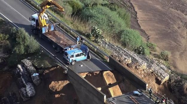
Photo credit above: "
This
picture taken from a video released by the Italian Police Tuesday, Nov.
19, 2013, shows a wrecked police car recouped from a crack in a bridge
caused by torrential rains, in Dorgali, Sardinia. A policeman helping to
escort an ambulance died when the car he was traveling in was submerged
in the collapse of the bridge. The Mediterranean island of Sardinia,
prized by the jet-set for its white sand beaches and crystal-clear seas,
was a flood-ravaged mud bath Tuesday after a freak torrential rainstorm
killed at least 17 people, downed bridges and swept away cars. Olbia
Mayor Gianni Giovannelli said the city had been destroyed by the
"apocalyptic" storm, with bridges felled and water levels reaching 10
feet in some places. He described the ferocity of the storm's rains as a
"water bomb." Photo: Polizia Di Stato, AP.
* more details on the extreme flooding in Sardinia, Italy from
The BBC.
Cut-Off Low.
The 15-20" rains reported in Sardinia were the result of weather
systems stalling, a persistent cut-off low over the Mediterranean Sea.
At one point this was a "warm core" system, vaguely resembling a weak
tropical storm, tapping significant moisture from the Mediterranean and
converting it into relentless rains. Map: Florida State University.
Which Countries Are Most At Risk From Super Storms And Extreme Weather? AlterNet
has the story - here's an excerpt: "...All ten of the countries most at
risk from extreme events in the 1993 to 2012 period were developing
countries, emphasising the message in Warsaw that poor countries cannot
cope with the increasing number of catastrophes by themselves. The major
issue at the conference in the wake of the current Philippine disaster
is how to finance “loss and damage” caused by an increasingly unstable
climate. The index, compiled by a think tank called Germanwatch from
figures supplied by the giant re-insurance company Munich Re, lists ten
countries most affected in 2012 and the long-term climate risk from loss
of life and damage from 1993 to 2012..." (Image: NASA).
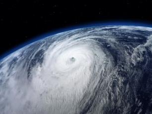
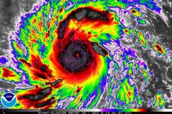
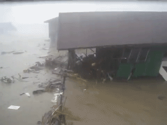
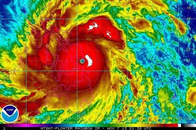
Incredible Footage Of Super Typhoon Haiyan's Storm Surge.
I've never (ever) seen the water come up this rapidly - I can now see
how many observers compared Haiyan's storm surge with a tsunami. The
YouTube footage is
here.
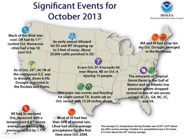
October Weather Highlights.
From record blizzards in the Dakotas to historic flooding in the
Austin, Texas area, to an EF-4 tornado near Wayne, Nebraska - October
had something for everyone. Map:
NOAA NCDC.
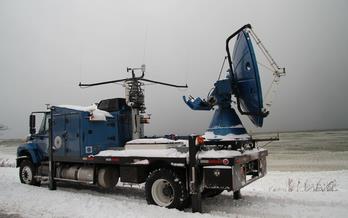
Scientists Brave Old Man Winter To Dig Out Secrets Of Lake Effect Snows. The
NSF (National Science Foundation) has the story - here's a clip: "'
Tis
the season...for snow. Thundersnow. Rare anywhere, thundersnow is
sometimes heard during the lake-effect snowstorms of the Great Lakes.
The interaction of clouds and ice pellets inside these storms generates a
charge, with lightning and thunder the result. How to catch thundersnow
in action? This winter, stalwart veterans of tornadoes, hurricanes and
other severe storms will be watching. One is known as the
Doppler-on-Wheels (DOW), a National Science Foundation (NSF) national
facility used by NSF-supported and other researchers. Joining it is a
University of Wyoming instrumented aircraft, the King Air, also an
NSF-funded national facility..."
Photo credit above: "
During the OWLeS project, scientists will dash through the snow in the Doppler-on-Wheels." Credit: CSWR.
Residents Of Most Polluted Cities - New York City, Chicago, Los Angeles And Miami - Have Increased Risk Of Dry Eye Syndrome. This one made me do a double-take; here's an excerpt from
Red Orbit: "
Residents
of major cities with high levels of air pollution have an increased
risk of dry eye syndrome, according to a study presented at the world’s
largest ophthalmic conference, the 117th Annual Meeting of the American
Academy of Ophthalmology, in New Orleans. Study subjects in and around
Chicago and New York City were found to be three to four times more
likely to be diagnosed with dry eye syndrome compared to less urban
areas with relatively little air pollution. As a result of this study,
researchers suggest that environmental manipulations should be
considered as part of the overall control and management of patients
with dry eye syndrome..."
Starbucks Puts A Coffee Shop On Rails. Just when you thought they couldn't jam in another Starbucks on your block - let's put them on rails! Here's a clip from
Gizmag: "
Apparently
not content with putting a coffee shop on every second street corner,
Starbucks has teamed with Swiss Federal Railways (SBB) to expand into
rail travel with the unveiling of the first railway carriage converted
into a Starbucks. The double-decker car uses a design that combines
design elements based on coffee with Swiss detailing in what Starbucks
calls the smallest bar it has ever designed..."
Why Do I Always Wake Up 5 Minutes Before My Alarm Clock Goes Off? Great question - here's a clip of an explanation at
Mental Floss: "
Because
your body’s internal clock is just as good, if not better, than the
contraption shrieking atop your nightstand. At the center of your brain,
a clump of nerves—called the suprachiasmatic nucleus—oversees your
body’s clock: the circadian rhythm. It determines when you feel sleepy
and when you feel bright-eyed. It controls your blood pressure, your
body temperature, and your sense of time. It turns your body into a
finely tuned machine. That machine happens to love predictability. Your
body is most efficient when there’s a routine to follow. So if you hit
the hay the same time each night and awake the same time each morning,
your body locks that behavior in. And that’s where things get sciency..."
Everyone In The World Hates Their Jobs - But Americans Hate Theirs The Most.
Fast Company has results of a recent survey - here is a clip from an interesting story: "
We
suppose this survey of 8,000 workers across the United States, Canada,
India, and Europe makes it somewhat official: America is number one!
Number one in the percentage of employees who hate their jobs, that is.
Monster.com and market research company GfK conducted the study, which
revealed that only 53% of Americans actively enjoy their jobs, and 15%
actively dislike them. Canadians, meanwhile, took top prize for having
the cheeriest workforce: 64% of Canadians like their jobs, while only 7%
hate what they do..."
I Stop Breathing When I Type, And You Probably Do, Too. And yes, I do to, although I didn't realize it until I confronted this article from
Gizmodo; here's a clip: "...
It turns out this is a thing. It's called "email apnea." According to one (very unscientific) estimate, about 80 percent of us do it.
That includes you. To quell any immediate anxiety this new diagnosis
might cause, I should say that I think I've suffered from email apnea
ever since my family bought our first Packard Bell desktop,
and I'm a relatively healthy person. Email apnea also isn't really a
medical condition, at least not one that a doctor will give you medicine
for. It does have medical effects, though—so listen up. The term "email
apnea" was coined in 2008 on the Huffington Post by Linda Stone, a former Apple executive who's done extensive work on the physiology of our relationship with technology..."
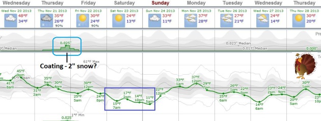
TODAY: Mostly cloudy, still mild. Winds: South 15. High: 48
WEDNESDAY NIGHT: Turning windy and colder. Low: 30
THURSDAY: Clouds increase. Light snow nighttime hours. Slick late with 1" of snow possible. High: 33
FRIDAY: Early slush, partial clearing. Wake-up: 26. High: near 30
SATURDAY: Cold, scrappy clouds and sun. Windchill: 5. Wake-up: 13. High: near 20
SUNDAY: Not as numb. Clouds increase. Wake-up: 12. High: near 30
MONDAY: Mix of clouds & sun, average temperatures. Wake-up: 27. High: 35
TUESDAY: Patchy clouds, cold wind. Wake-up: 22. High: 28
Climate Stories...
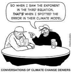
Conversations of Climate Change Deniers. Credit
here.
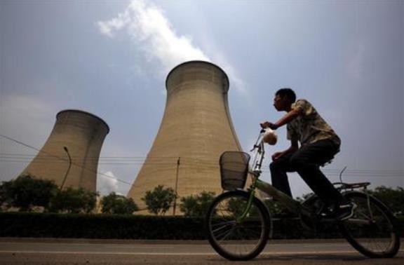
Global Carbon Emissions Rise To New Record In 2013 - Report.
Reuters has the story; here's the introduction: "
Global
carbon dioxide emissions from burning fossil fuels will rise to a
record 36 billion tonnes this year, a report by 49 researchers from 10
countries said, showing the failure of governments to rein in the main
greenhouse gas blamed for global warming.
The report by the Global Carbon Project, which compiles data from
research institutes worldwide each year, was published in the journal
Earth Systems Data Discussions on Tuesday.
Its 2013 estimate represents a 2.1 percent gain versus 2012 and a 61
percent increase since 1990, the baseline year for the U.N.'s Kyoto
Protocol, the only global agreement that places binding limits on
national CO2 emission levels..."
Photo credit above: "A man rides his bicycle past the cooling tower and chimneys from a coal-burning power station in Beijing June 1, 2012." Credit: Reuters/David Gray/Files.
Haiyan Is An Example Of Climate Change Making Things Worse. Here's a clip from climate scientist Greg Laden at
scienceblogs.com: "...
The
exact nature of future storms is uncertain, but there are four lines of
scientific evidence that hurricanes will be more of a problem in the
future than they were in the past. First, sea levels continue to rise,
so the same storm ten years from now vs. ten years ago will have
significantly greater impact. Sea level rise was a significant factor
with Superstorm Sandy and Katrina, and was likely a factor in the high
death toll and extensive damage caused by Haiyan. Second, large storms
are likely to produce more rain over a broader area
because a warmer atmosphere contains more moisture; large storms will
bring increased inland flooding, a major cause of damage, injury, and
death in tropical storms and cyclones. Third, increased sea temperatures
may generate more intense storms..."
The New Normal?
Is a warmer atmosphere, with more water vapor (especially over and near
the world's oceans) flavoring all weather, and making weather extremes
more numerous and severe? Here's a clip from a story at
The Economist: "...
In
theory, a warmer world should indeed produce more potent cyclones. Such
storms are fuelled by evaporation from the ocean. Warmer water means
faster evaporation, which means more energy to power the storm. A warmer
atmosphere can hold more moisture, which means more rain. But other
factors complicate things. Tropical cyclones cannot form when wind
speeds in the upper and lower atmosphere differ too much. Climate models
suggest, in the North Atlantic at least, that such divergent winds may
be more common in a warmer world. The Intergovernmental Panel on Climate
Change (IPCC) reckons that the frequency of cyclones will stay the same
or decrease while their average intensity goes up..."
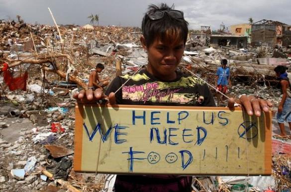
Why Disasters Like The Typhoon In The Philippines Will Keep Getting Worse. According to this article at
Pacific Standard, climate change is only part of the story; here's an excerpt: "
Basically,
as the world's population continues to grow, more and more people are
heading for the most economically attractive places, which tend to be
cities, which tend to be along coastlines. That's why the number of people living in Tacloban has tripled in recent decades,
from 76,000 in 1970 to more than 220,000 when the storm hit. Obviously,
that puts three times as many people at risk of being killed when
disaster strikes. But population growth compounds risk in other ways.
All those people drawing water from underground aquifers can cause the
already low-lying land to sink further. That's probably part of the reason so much of Tacloban sits below sea level,
a fact which makes the city even more vulnerable to flooding.
Shoddily-constructed buildings thrown up in a hurry to house all those
newcomers also tend to fall down when the going gets rough..."
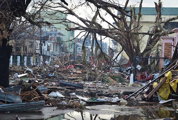
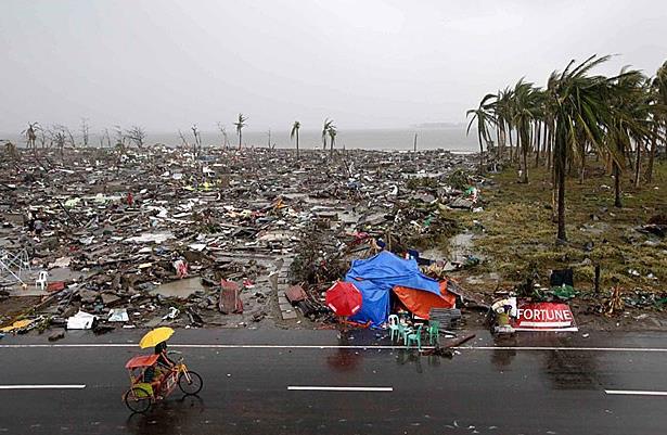
Photo credit above: "
Debris littering the streets of Tacloban on November 14, nearly a week after the storm struck." (PHOTO:
TROCAIRE/WIKIMEDIA COMMONS).
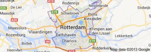
Rotterdam: Designing A Flood-Proof City To Withstand Climate Change. Here's a snippet of a story dealing with adaptation from
The Guardian: "...
Surrounded
by water on four sides, this delta city of some 600,000 people can't
flush the sudden stormwater away. Instead, it has embarked on a climate
change adaptation strategy
that turns every conceivable area into water storage. "We have squares
that are set lower than the surrounding streets and pavements that will
function as water plazas and fill themselves up with water", explains
van Huffelen. "We've also built water storage facilities, for example an
underground parking garage with a basin the size of four Olympic
swimming pools. And we've introduced more green areas, including green
roofs and green facades, that will be able to absorb water as well..."
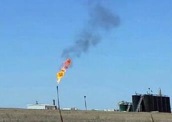
Colorado To Tighten Drilling Rules.
In addition to ongoing concerns about contamination of ground water
supplies, there is growing apprehension about methane leakage around
these hydraulic fracture (fracking) wells. Here's a clip from
The Wall Street Journal: "...
The
state's proposed rules include first-in-the-nation regulations to force
energy companies to reduce the emission of methane, a potent greenhouse
gas linked to global warming that is the major ingredient in natural
gas. The rules also attempt to cut emissions of volatile organic
compounds, which some scientists say raise ozone levels and contain
cancer-causing pollutants..."
What Farmers Think About Climate Change In One Great Quote. Here's a clip from a story at
Business Insider: "...
Here is what Climate Corporation founder Dave Friedberg said about how most farmers view climate change (emphasis ours):
"You
don't need to talk about climate change per se ... Statistically, you
are looking at a series of numbers. If it were a roulette wheel, you
could say, 'It's coming up black more and more frequently.' Can I
attribute that to black being overweighted by the croupier? Or to the
pit boss, or the machine being broken? It doesn't matter.
Some people will argue that ice ages have waxed and waned for tens of
millennia and that this is part of a natural cycle. That doesn't change
the fact that black is coming up more frequently and you will
get less out of an acre of corn than you used to. The price for that
land simply cannot be justified by the income it can generate."
In
other words, it doesn't matter what's causing it, but something's
definitely not right, and investing in protection from that uncertainty
now seems a must..."
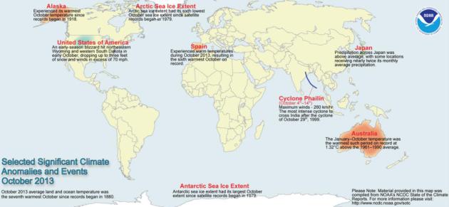
Global Climate Events In October. Data courtesy of
NOAA NCDC.
All Over The World, Hurricane Records Keep Breaking. A symptom of warmer seas or a statistical fluke? Chris Mooney takes a look at
Mother Jones; here's an excerpt: "...
But
here's the thing: Haiyan isn't the globe's only record-breaking
hurricane in recent years. Even as scientists continue to study and
debate whether global warming is making hurricanes worse, hurricanes
have continued to set new intensity records. Indeed, a Climate Desk
analysis of official hurricane records
finds that many of the globe's hurricane basins—including the Atlantic,
the Northwest Pacific, the North Indian, the South Indian, and the
South Pacific—have witnessed (or, in the case of Haiyan and the
Northwest Pacific, arguably witnessed) some type of new hurricane
intensity record since the year 2000. What's more, a few regions that
aren't usually considered major hurricane basis have also seen mammoth
storms of late..." (Image: NOAA).
Haiyan, Sandy And Climate Change. Jeff Nesbit has the story at
U.S. News; here's the introduction: "
Is
climate change responsible for the devastation caused by Super Typhoon
Haiyan – the strongest tropical cyclone to make landfall in recorded
history? Was it responsible for Superstorm Sandy, which caused billions
of dollars of damage to New York City and New Jersey? More broadly, is
climate change starting to have an impact today on such extreme weather
events? The answer to those questions is a complicated one, but it
starts with the word "yes". Scientists have spent years researching
climate change's role in specific, extreme events such as Haiyan and
Sandy. But what climate scientists know today, with a high degree of
certainty, is that all extreme weather events are now occurring in a
world where the oceans are warmer, sea levels are higher and
temperatures are rising. So the odds of more intense, devastating storms
like Haiyan and Sandy are increasing every year..."
Photo credit above: "
A resident bikes past the devastation in Tacloban, central Philippines."
Gaps In Data On Arctic Temperatures Account For The "Pause" In Global Warming. Here's more information on the recent discovery, courtesy of
The Independent: "...
That
much-vaunted “pause” in global warming can be largely explained by a
failure to record an unprecedented rise in Arctic temperatures over the
past 15 years, a study has found. Two independent scientists have found
that global temperatures over the past decade have almost certainly
risen two-and-half times faster than Met Office scientists had
conservatively assumed when they estimated Arctic warming because of a
lack of surface temperature records in the remote region. Moreover, when
the latest estimates of Arctic temperatures are included in the global
temperatures, the so-called “pause” in global warming all but disappears
and temperatures over the past 15 or so years continue to increase as
they have done since the 1980s, the scientists said..."
Surviving Climate Change: Is A Green Energy Revolution On The Global Agenda? Here's a clip from a story at
Huffington Post
that made me do a double-take. Will it really come to this? I hope we
come to our senses long before there are protests on the streets, but
some days I wonder: "...
Nobody can say that a green energy
revolution is a sure thing, but who can deny that energy-oriented
environmental protests in the U.S. and elsewhere have the potential to
expand into something far greater? Like China, the United States will
experience genuine damage from climate change and its unwavering
commitment to fossil fuels in the years ahead. Americans are not, for
the most part, passive people. Expect them, like the Chinese, to
respond to these perils with increased ire and a determination to alter
government policy. So don’t be surprised if that green energy revolution
erupts in your neighborhood as part of humanity’s response to the
greatest danger we’ve ever faced. If governments won’t take the lead on
an imperiled planet, someone will..."


No comments:
Post a Comment