28 F. high in the Twin Cities Thursday.
26 F. average high on December 19.
32 F. high on December 19, 2012.
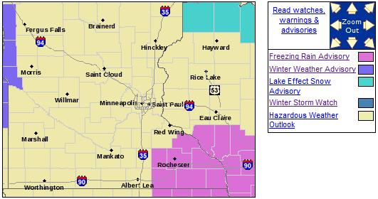
Freezing Rain Advisory until 9 am for southeastern Minnesota
Monday and Thursday of next week: coldest days.
Cold bias lingers next 1-2 weeks.
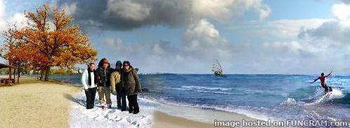 Crazy Contradictions
2013
was another year of head-shaking weather. Yes, the atmosphere has
always been fickle, capable of wild extremes, but there's evidence of
more volatility in the system.
It was the Year of All or Nothing.
Minnesota's
drought eased by late spring, then returned suddenly with a late summer
"flash drought". Heavy snow fell in early May and the Arrowhead saw a
rare August frost. SPC reported 11 Minnesota tornadoes, a third of what
we normally see. But the June 21 "Solstice Storm" produced 80 mph
straight-line winds that toppled thousands of trees.
2013 was the
quietest year for hurricanes in the Atlantic since 1982, but the Pacific
was very active. Typhoon Haiyan was one of the most powerful storms
ever observed, leaving over 6,000 dead in the Philippines.
The
return of Fresh Air sets off an inch or two of fluff early today,
another coating to an inch Saturday night, as a reinforcing clipper
arrives. No prolonged thaws are brewing; 20F Christmas Day, maybe 30F
the following Saturday, December 28.
Until the pattern shifts and steering winds blow from New Mexico it'll be tough getting any big storms into Minnesota.
At least snow lovers are having a better winter than usual - and we'll all get to enjoy a very white Christmas.
* image above courtesty of
funcram.com
Ice Risk Southeast.
A Freezing Rain Advisory is in effect thru the morning hours today;
rain and drizzle freezing on contact with cold surfaces. More details
from NOAA:
FREEZING RAIN AND DRIZZLE IS OCCURRING ACROSS NORTHEAST
IOWA...SOUTHWEST WISCONSIN AND SOUTHEAST MINNESOTA. ICE COVERED
ROADS HAVE BEEN REPORTED ACROSS NORTHEAST IOWA AND SOUTHWEST
WISCONSIN WHERE TRAVEL IS NOT RECOMMENDED. ICE ACCUMULATIONS OF
1/10 OF AN INCH OR LESS ARE EXPECTED ON MOST EXPOSED
SURFACES...INCLUDING ROADWAYS AND SIDEWALKS. PLAN ON SLICK AND
SLIPPERY ROAD CONDITIONS... ESPECIALLY FOR THE FRIDAY MORNING
COMMUTE. USE CAUTION BEFORE HEADING OUT.
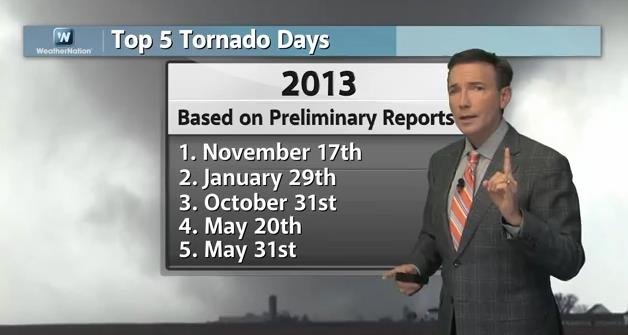
2013: All Or Nothing For Tornadoes And Hurricanes.
In today's edition of Climate Matters we recap last year's Christmas
Day tornado outbreak, a reminder that December is still prime time for
tornadoes along the Gulf Coast and Florida. It was a very quiet year for
hurricanes (in the Atlantic), and the USA saw fewer tornadoes than
average, but from Moore, Oklahoma to Washington, Illinois (on November
17) there were large and deadly exceptions to that rule. The day with
the most tornadoes: November 17 (74 touched down). I haven't seen that
before: "
WeatherNationTV Chief Meteorologist Paul Douglas goes over
the severe weather set up on Saturday and shows that December tornadoes
aren't out of the realm of possibility. How has this year stacked up to
others weather wise. After seeing the damage to Washington, IL, we're
actually BELOW average for the number of tornadoes on the year. And the
Atlantic hurricane season wasn't nearly as active as years past, just
how weak was it and why?"
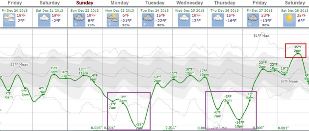
A (Mostly Cold) Temperature Roller Coaster.
ECMWF guidance above shows a chilly stretch into much of Christmas
week, the coldest weather coming next Monday, again Thursday, before
temperatures possibly rebound the end of next week. I still think the
"Euro" is overestimating the cold a bit, but it probably has the right
general idea of the timing of these next cold slaps. Graphic:
Weatherspark.
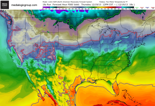
Big Extremes.
By Saturday subzero air pushes into the Northern Plains, while 60s and
70s surge up the East Coast, setting the stage for a significant storm:
snow for the Midwest and Great Lakes, potential flooding over the Ohio
Valley, and even a severe storm and tornado outbreak from the Mid South
to the Gulf Coast. 2-meter NAM temperatures going out 84 hours courtesy
of NOAA and Ham Weather.
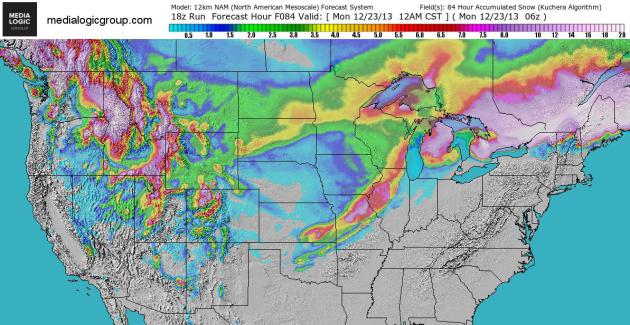
84 Hour Snow Potential.
Amounts don't look quite as impressive across the Midwest, but plowable
snows are still posssible from near Wichita and Kansas City to Peoria,
Rockford, Madison and Milwaukee. Chicago may still pick up a couple
inches, but the heaviest snow band will probably stay north/west of The
Windy City. NAM guidance: NOAA and Ham Weather.
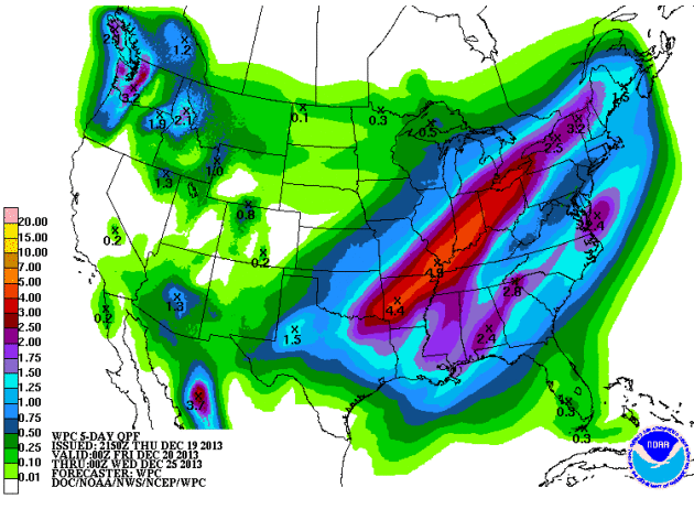
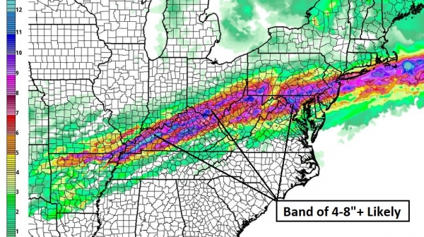
Flood Risk.
A plume of moisture flowing out of the Gulf of Mexico will fuel an
intensifying storm, and NOAA guidance suggests some 3-5" rainfall
amounts from Little Rock and Louisville to Indianapolis and Cleveland,
capable of urban and small stream flooding. QPF map: NOAA.
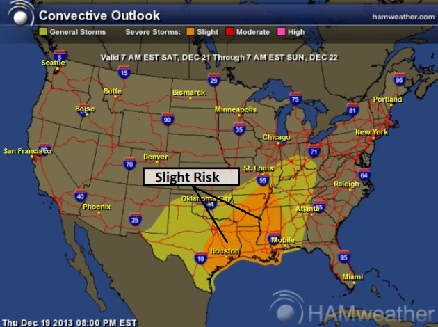
Saturday Severe Storm Potential.
SPC has much of the Mid South and Gulf Coast under a "slight risk" of
severe storms. Keep an eye on this - if the threat level goes to
"moderate" the risk of large, potentially violent tornadoes will be
significant. Map: NOAA and
Ham Weather.
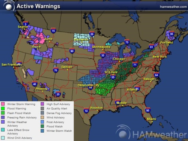
Current Watches, Warnings And Advisories. From Winter Storm Watches and Advisories to Flood Watches, there will be plenty of weather to track from now thru Sunday.
Click here to see the latest NOAA information, courtesy of Ham Weather.
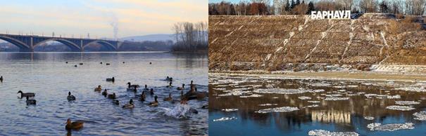
No Snow In Siberia? Locals Marvel - And Worry - At The "Snow Shortage".
Much of the northern USA has snow on the ground, but portions of
Siberia are experiencing an abnormally mild, largely snow-free December,
to date. Here's a clip that caught my eye from
The Siberian Times: "...
The
startling pictures from Krasnoyarsk show an almost total absence of
snow yet as every school child around the world knows, snow is what
Siberia is all about. No more, it seems. The images of the River Yenisei
with ducks splashing in the water, and grass in the parks, could be
from autumn rather than deep in the winter in a city where December
temperatures have gone as low as minus 47C, and the daily mean in minus
13C at this time of year, with plenty of snow on the ground. As in many
areas of Siberia this winter, the thermometer is reluctant to plummet
to customary bone-chilling temperatures. Last night when we checked
outside, it was a mere minus 3C. Day time temperatures lately have been
warmer. As mother-of-two Anastasia said from Krasnoyarsk: 'I'm reading a
book to my children and I hear the tapping of the rain in my ear. Rain?
Rain??? Rain in the middle of December? In Siberia?...."
Photo credit above: "
Recently,
experts have sounded warnings about the impact of climate change, with
one warning that the energy-rich Yamal Peninsula in Siberia could be
flooded due to a rise in sea levels - along with some famous cities." Picture from Barnaul, Western Siberia, courtesy
Sergey Scherbin, Barnaul.fm
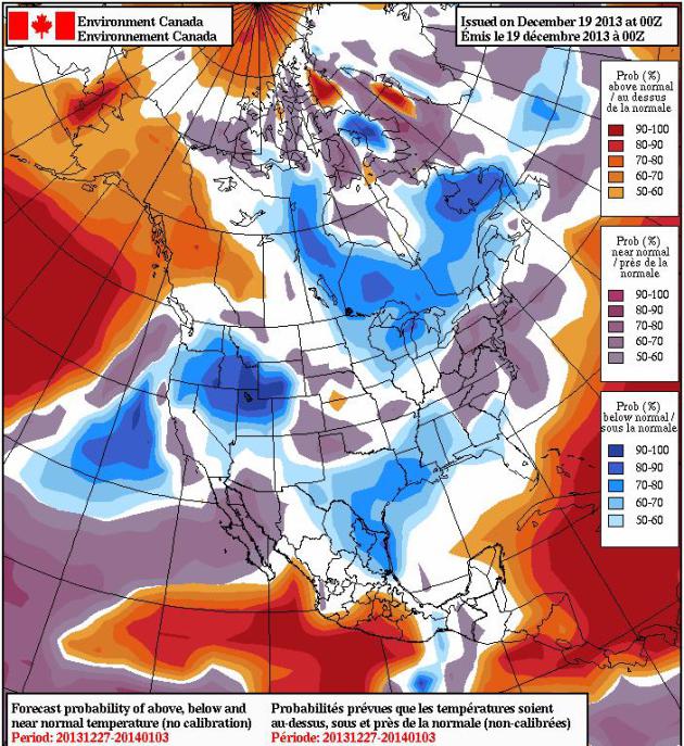
Cold Bias Into Early 2014. The latest NAEFS model, courtesy of
Environment Canada,
shows warmer weather for much of Alaska and western Canada, but a cold
bias for much of central and eastern Canada and a fairly large chunk of
the Lower 48. Any January Thaw will be fleeting this year - we may have
to wait a few more weeks to really thaw out.
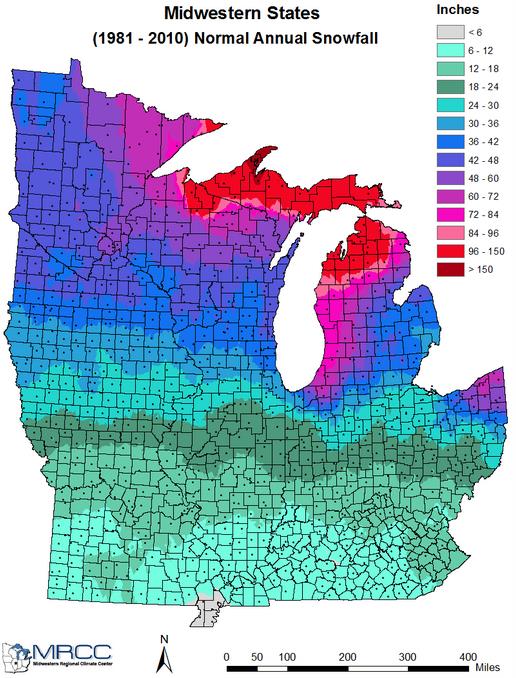
Average Winter Snowfall.
I thought this was a timely graphic to show, displaying average winter
snowfall from the Upper Mississippi Valley into the Great Lakes and Ohio
Valley. Of course the weather is never average; we careen from one
extreme to the next. Since 1998 winters have trended milder, with
considerable volatility. Some winters see little snow, while others have
been well above average in the snowfall department. Graphic: Midwest
Regional Climate Center.
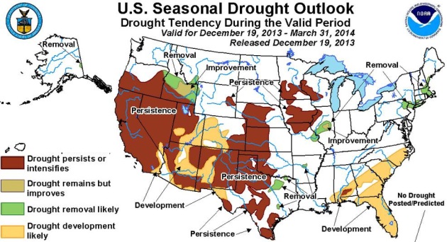
Drought Outlook.
NOAA's latest drought outlook through the end of March shows a
potential for persistent drought over parts of central and southern
Minnesota and southwest Wisconsin into Q1 of 2014.
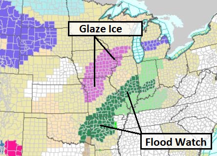
Alerts Broadcaster Briefing: Issued Thursday, December 19, 2013.
*
Potential for glaze ice event Friday from Missouri and Iowa into
southern Wisconsin. Flash flood risk Middle Mississippi Valley.
*
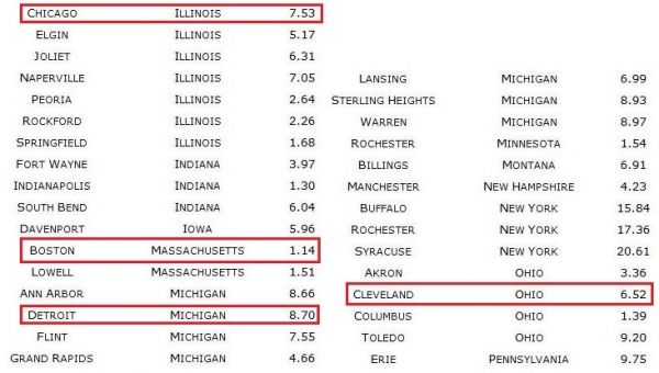
Heavier band of snow sets up from near Kansas City to Quad Cities and
Madison Sunday and Sunday night - probably enough to shovel and plow.
Chicago and Detroit will probably miss the worst of this late weekend
storm.
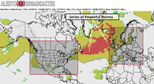
* Series of very powerful storms spinning up in the North
Atlantic, capable of wind damage and power outages across U.K., Ireland
and Scotland - greatest risk coming Thursday of next week.
Current Watches & Advisories.
NOAA has issued Freezing Rain Advisories from Kansas City to Des Moines
and Madison from late tonight into Friday as rain falls on surfaces
colder than 32F. Some glaze icing is possible over this part of the
Midwest tomorrow. Chicago should not be affected. Map: NOAA.
Sunday Snow Event.
A second storm tracking across the center of the U.S. will drop a
relatively narrow carpet of significant snow, from near Wichita and
Overland Park to Des Moines, Quad Cities, Rockford, Madison and
Milwaukee. Chicago may see a few inches of slush by Sunday night, but
the brunt of the accumulating snow tracks north and west of The Windy
City. NAM guidance: Ham Weather.
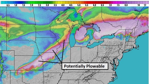
High-Res Solution.
As much as 10" of snow is predicted for parts of Kansas, closer to 5-6"
southern and eastern Iowa into far northwest Illinois and the
southeastern third of Wisconsin, including Madison, Milwaukee and Green
Bay. Lower Michigan will pick up as much as 8-10", but the snow bands
should stay north/west of Lansing, Ann Arbor and Detroit.
Snowfall Potential.
I suspect GFS amounts (above) are running a little high, but they have
the right idea, especially over Kansas, Missouri and Wisconsin. Chicago
is still something of a meteorological wild card; I'm expecting a couple
inches of slush late Sunday, but right now it appears the heaviest
amounts will stay north and west of Chicago, closer to Rockford,
Janesville, Madison and Milwaukee.
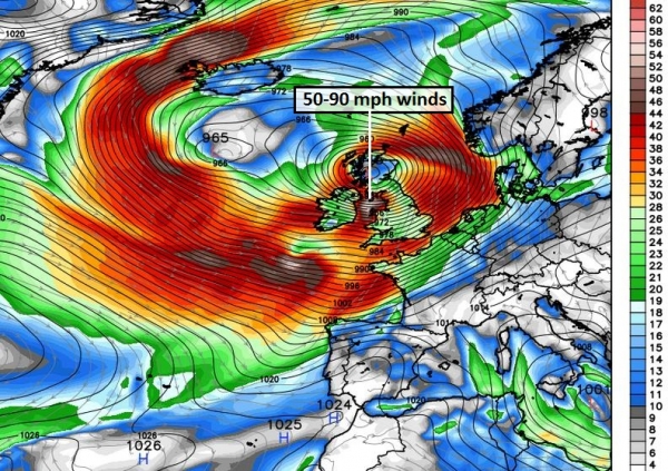
Another Wild Week for Britain.
Our internal Alerts Broadcaster models show a very significant risk of
wind-damage, power outages and some level of urban and river flooding,
especially over the United Kingdom, as a parade of intense, even violent
storms surge across the North Atlantic into the British Isles. It's
early, but right now it appears the worst of the storms may arrive a
week from today, with wind gusts possibly reaching hurricane force.
Graphic: Ham Weather.
Next Thursday, December 26.
The GFS solution shows an extremely powerful storm over Wales, a tight
pressure gradient whipping up sustained winds of 30-50 mph with gusts
approaching hurricane force over much of the British Isles one week from
today. We'll keep an eye on it, but facilities in the U.K., Ireland and
Scotland will be impacted by a series of extreme storms. (Graphic:
WeatherBell).
Summary: Midwestern operations will
be impacted by rain, ice and (Sunday) snow, as the next surge of cold
air pushes east - while eastern cities as far north as New York City and
Philadelphia enjoy 60s on Saturday, 70s from Washington D.C. to
Charlotte and Raleigh, highly unusual for the third week of December.
We're tracking a series of unusually intense storms across the North
Atlantic and North Sea, capable of disrupting operations, especially
United Kingdom, over the next 7-10 days.
Paul Douglas - Senior Meteorologist - Alerts Broadcaster
An Explosion In Slow Motion: How 2013 Blew Apart Our Notions Of Privacy. Here's an excerpt of an excellent and vaguely terrifying story at
Gigaom: "
2013
was an extraordinary year for those of us who are interested in privacy
and data protection. What was previously seen as the domain of paranoid
nitpickers has exploded into the public consciousness, shaking
international ties and making many people re-evaluate how they live
their lives online. But it would be a mistake to see 2013 purely in
terms of Edward Snowden and his revelations. Indeed, months before the
former NSA contractor downloaded what he could and fled to Hong Kong,
the year began as it meant to go on: by demonstrating the power and
dangerous potential of our increasingly open, plugged-in nature..."
Identity Theft: America's Fastest-Growing Crime Barely Even Registers As "Crime" For Most People.
The Atlantic Cities takes a look at the resources going into hacking YOU. Here's an excerpt: "...
Property
and violent crime affect us where we live and work, and we expect local
government to do something about them. But even though these categories
seem comprehensive, neither one includes identity theft. Considering
identity theft now costs Americans nearly twice as much as property
crime, that's an odd omission. In a recent report, the U.S. Bureau of
Justice Statistics found that total losses attributed to identity theft in 2012 were $24.6 billion, compared to $13.9 billion for property crimes..."
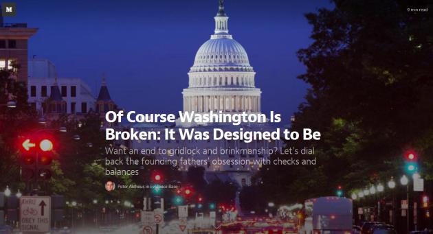
Of Course Washington Is Broken: It Was Designed To Be. Here's a sobering look at what Washington D.C. has become, and what's needed to fix the perpetual gridlock, courtesy of
Medium.com: "
For
a group of people dependent on public support for its professional
survival, Congress has done a truly remarkable job of alienating the
American public. Over the past four decades, the polling firm Gallup has
regularly asked U.S. adults about their level of confidence in various
institutions. In June of this year, Congress hit rock bottom:
Just 10 percent of respondents expressed a “great deal” or “quite a
lot” of confidence in the legislative branch of government. That’s down
from 42 percent in 1973—a year blighted by an international oil crisis
and marked by the country’s withdrawal from Vietnam.."
8 1/2 Things That Went Right In 2013.
Bloomberg BusinessWeek has the upside to another crazy year; here's the introduction: "
It
was a year of cronuts and pretzel buns, green eggs and ham, of Syria
and Mali and the East China Sea, of Edward Snowden and Pope Francis, Xi
Jinping and Kim Jong Un. Jeff Bezos showed off a package-delivering
drone. Twitter (TWTR) tweeted its own IPO announcement. Stocks went up, housing revived, unemployment fell, and banks got fined. American Airlines (AAL)
and US Airways merged, and a solar-powered airplane hopscotched across
the U.S. We can’t discern much of a pattern here. But in the spirit of
the holidays, here’s a look on the bright side—a list of the things that
went right in 2013, sometimes unexpectedly. It is short, admittedly,
but sweet. May 2014 be better yet..."
TODAY: Icy start. Snow tapers early. PM clearing - still cold. Winds: NW 5-10. High: 13
FRIDAY NIGHT: Patchy clouds. Low: 8
SATURDAY: More clouds than sun. High: 22
SUNDAY: Cold wind, dusting or coating of flurries. Wake-up: 4. High: 8
MONDAY: Slow clearing. Feels like -15F. Wake-up: -11. High: 2
CHRISTMAS EVE: Light snow. Couple inches late? Wake-up: -1. High: 19
CHRISTMAS: Very White Christmas. Some sun. Wake-up: 13. High: near 20
THURSDAY: Patchy clouds, partially numb. Wake-up: -1. High: 9
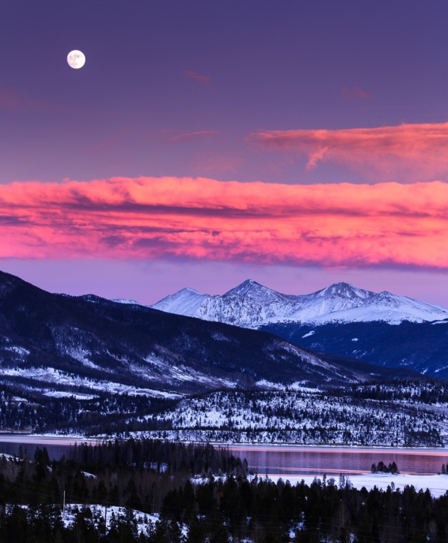
* Photo above courtesy of Steve Burns, who snapped this photo on a ski trip to Colorado: "
Shot from Frisco, this is looking east over the Front Range and the two 14ers of Grays Peak and Torreys Peak."
Climate Stories...
“Those who have the privilege to know have the duty to act.” - Albert Einstein
Poll: Americans See Impact Of Global Warming. Here's a clip from a story at
USA Today:
"
Most Americans say global warming is serious and want the United
States to address it, but their support for government regulations has
fallen in recent years, says a poll out Friday conducted for USA TODAY.
Three of five say global warming is a very serious global problem, and
two of three say it will hurt future generations either a lot or a great
deal if nothing is done to reduce it, according to the poll of 801 U.S.
adults done in conjunction with Stanford University and Resources for
the Future, a non-partisan research group, which funded the
research...."
Most Companies Still Releasing Unsustainable Amounts Of CO2 - Study.
Reuters has the findings; here's the introduction to the story: "
The
majority of large global corporations that have reported their annual
greenhouse gas emissions for several years now are still releasing more
carbon dioxide than they should, a new study published on Wednesday
showed. And most companies
scrutinized in the study are still not using science-based thresholds to
set emissions targets and to drive actions to reduce their carbon
footprint. Coordinated by
U.S.-based Climate Counts, an organization that measures the role
corporations play on climate, the report tried to analyze emissions of
100 companies against science-based targets that seek to limit rising
temperature to two degrees Celsius..."
White House To Get Aggressive On Climate Change? Here's a clip from
The Washington Post: "...
Environmentalists
are looking at this today with a sense of optimism, since they have
been pushing the White House for years to get aggressive on climate
change with executive action, the only avenue available, given the
reality of today’s Congress. But what would it look like if
Podesta actually gets the White House to go through with this in a
comprehensive way? One place to start for an answer is a report on what a president can accomplish with executive action
that was written by one…John Podesta, before he joined the White House.
It suggests an array of executive actions that a President can take on
climate change..."
Photo credit above: "
Can this guy get the White House to get tough on climate change?" (AP Photo/Eric Jamison).
Why Environmentalists Should Hope Nuclear Power Sticks Around. Here's an excerpt of an Op-Ed at
The Washington Post: "...
Some
environmentalists cheer the closing of nuclear plants, even though it
makes the anti-carbon effort tougher, and they argue that the country
should put all of the planet’s eggs into the renewables basket. The
pro-nuclear crowd predicts that a new wave of innovative technologies
will make constructing new nuclear plants much more attractive,
technically and economically. The country — and particularly
environmentalists — should hope the pro-nuclear side is right; a
renaissance in nuclear technology could offer the country a source of
reliable, carbon-free electricity with safer designs than those of
decades ago, all of which would be particularly helpful if renewables
never burst out of their niche end of the market..." (File photo: CNN).

Climate And Economic Models - Birds Of A Different Feather. University of St. Thomas climate scientist John Abraham describes the differences in this story at
The Guardian; here's an excerpt: "...
We
can see the two big weaknesses with business models. First, they do not
follow any universal conservation equations. There is no analogy for
mass, momentum, and energy in a business model. Second, behavior of
economies in the past may not be a proper indicator of the future.
Should we expect the U.S. economic recovery from the great recession be
anything like the recovery from the Great Depression? Can stimulus or
austerity success or failure be predicted by past stimulus or austerity
cases? The answer is, we just don't know...."
Photo credit above: "
Climate modeling is done on some of the world's fastest supercomputers, like the UK's HECToR." Photograph: Murdo Macleod.
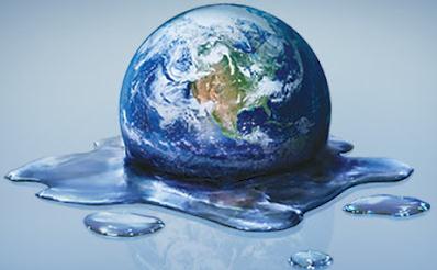
Climate Change Threatens Retirement Savings.
Do you have a 401K or a few mutual funds? At some point you may want to
check and see how many fossil fuel companies are in the investment mix,
according to this article at
Scientific American - here's an excerpt: "
The
Asset Owners Disclosure Project asked 1,000 of the world's largest
asset owners what they were doing to guard against the possibility that
their investments in fossil fuels
could, in future, become worthless. Together, the owners manage more
than $70 trillion. The Project found that only 27 of the 458 investment
funds replying to its request are addressing climate risk at what it
considers a responsible level. Only five of the 458 achieved the AODP's
top score, AAA. An additional 22 rated A or above. Only these groups,
says the Project, "will survive a carbon crash in any kind of good
shape..."
Image credit above:
Katrina Tuliao/Wikimedia Commons.
Rising Sea Levels Torment Norfolk, VA, And Coastal U.S. Here's an excerpt from a story and video provided by
USA Today: "...
Flooding
has become so common in this city, where water is the lifeblood, that
residents talk about it in the supermarket. Home to the world's largest
naval base, Norfolk sits on flat land — much of it filled-in marsh
that's now at sea level and sinking. Add to that the sea-level rise from
global warming, and the city faces what it deems a $1 billion-plus
problem. As the 10th part of its year-long series on climate change, USA
TODAY traveled to Virginia's picturesque Tidewater region — bound by
creeks, rivers and the Chesapeake Bay — to look at how rising sea levels
are affecting America's coastal communities, where more than a third of
its people and wealth reside..."
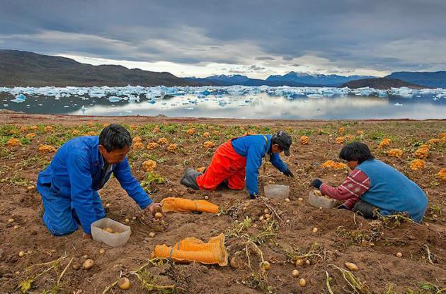
Documenting The Swift Change Wrought By Global Warming. Here's a clip from a photo essay at
Yale Environment 360: "
For
25 years, photographer Peter Essick has traveled the world for National
Geographic magazine, with many of his recent assignments focusing on
the causes and consequences of climate change. In a Yale Environment 360
photo essay, we present a gallery of images Essick took while on
assignment in Antarctica, Greenland, and other far-flung locales. The
photographer says that what most struck him was the dedication of the
scientists who have committed themselves to documenting the effects of
global warming..."
Photo credit above: Peter Essick. "
Inuit people harvest potatoes in southern Greenland, where temperatures have been rising rapidly."
View the photo essay.
Global Warming As Haiku. Chris Mooney has the story at
Mother Jones; here's an excerpt: "
Recently
at the annual American Geophysical Union meeting in San Francisco, a
number of climate researchers and communications specialists sounded off
about the problems involved in conveying climate science information to
the public. Naomi Oreskes, the Harvard science historian, noted one of the many challenges:
There's a huge gap between how grave the climate issue actually is, and
how clinical and detached climate scientists seem to sound when they
discuss it. "Our tone doesn't match our words," Oreskes said. As a
result, climate communications often lack emotional authenticity..."
Graphic credit above:
Gregory C. Johnson/Sightline.org.


No comments:
Post a Comment