Snow globe
By Paul Douglas
January came early this winter, but here's some encouraging news for Minnesotans counting the days until spring break. According to meteorologist Dean DeHarpporte tomorrow marks the earliest sunset time of the year: 4:31 PM. After that the sun sets later: 4:41 PM New Years Day and 5:00 PM by January 17. Dean points out that December 21 is the shortest day. He explains "The December acceleration of the earth in its orbit around the sun distorts the time of earliest sunset back to Dec. 9. To compensate, the sun will be rising later every day until Dec. 30, when it's latest sunrise is 7:51 AM."
A faint glimmer of good news for those of us trying to remember what "warmth" feels like. Models hint at 20s & 30s from next weekend to about December 22. NOAA's 45-Day CFS run, which is displaying real skill, shows a relatively mild first half of January (and 11 inches of snow on the ground at MSP for Christmas). We'll see.
When it's this cold snow piles up quickly; chemicals unable to melt ice. I expect a plowable snow today; maybe 2-5 inches of fluffy, powdery, Aspen-like snow.
Two more fleeting bursts of arctic air the first half of this week, then a welcome temperature recovery.
___________________________________________________
SUNDAY: Cloudy. Snow likely. 2" to 4" of fluff possible by evening. High: 12. Winds: SE 5-10. Wind Chill: Down to -10.
SUNDAY NIGHT: Mostly cloudy. Lingering light snow early, Any additional snow less than 1". Low: 1. Winds: Turning NW 10-15.
MONDAY: Bitter breeze returns with blowing snow. Sunshine early, then increasing clouds. Light snow possible overnight? High: 5. Winds: WSW 10-20
TUESDAY: Numbing wind. Another clipper with light snow showers. Wake-up: -3. High: 9
WEDNESDAY: More cold sunshine. Wake-up: -10. High: 4
THURSDAY: Patchy clouds, more tolerable. Light snow possible up north. Wake-up: -4. High: 17
FRIDAY: Partly sunny. Slight chance of a few snow showers. Wake-up: 6. High: 18.
SATURDAY: More clouds, a few flurries. Wake-up: 5. High: 17.
________________________________________________________________
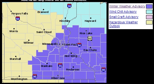
Winter Weather Advisory
The National Weather Service has issued a Winter Weather Advisory for southeastern MN and west central Wisconsin through 6am Monday.
...ACCUMULATING SNOWS RETURN FOR SUNDAY...
A BROAD AREA OF 2 TO 5 INCHES OF SNOW IS EXPECTED TO FALL SUNDAY ALONG AND SOUTHEAST OF A NEW ULM...TO THE TWIN CITIES...TO BALSAM LAKE LINE. SNOW WILL MOVE INTO SOUTHWEST AND SOUTH CENTRAL MINNESOTA AFTER MIDNIGHT AND MOVE INTO WESTERN WISCONSIN AFTER 6 AM. LIGHT TO MODERATE SNOW IS EXPECTED TO FALL FOR MUCH OF THE DAY AND INTO THE EVENING HOURS ON SUNDAY.
* TIMING: SNOW WILL MOVE INTO SOUTHERN MINNESOTA AFTER MIDNIGHT TONIGHT AND CONTINUE INTO SUNDAY NIGHT.
* MAIN IMPACT: SNOW ACCUMULATIONS OF 2 TO 5 INCHES.
* OTHER IMPACTS: WINDS INCREASING TO OVER 20 MPH LATE SUNDAY NIGHT INTO MONDAY WILL RESULT IN SOME BLOWING AND DRIFTING SNOW.
Sunday Snow Potential
Here's the National Weather Service's latest "Graphicast" which shows the snow potential for Sunday.

Holiday Season...
I know the holiday season can be a stressful time of year, but I have something that may help. It's a Stress Reduction Kit. See instructions below:

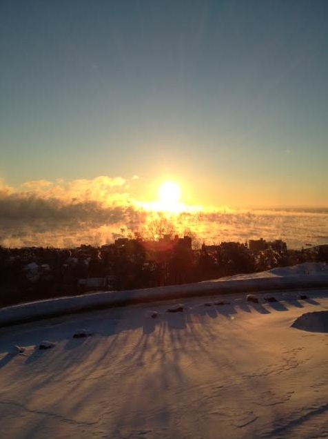
Cold Enough For Ya?
One of my favorite views during some of the first few Arctic outbreaks of the year is out of Duluth, MN. With Lake Superior water temperatures still in the upper 30s and Saturday morning air temperatures nearly -20F, steam rises due to the extreme temperature difference. It sure makes for beautiful sunrise pictures! Thanks to my good friends Wanda and Dale Brandt out of Duluth, MN for the picture below
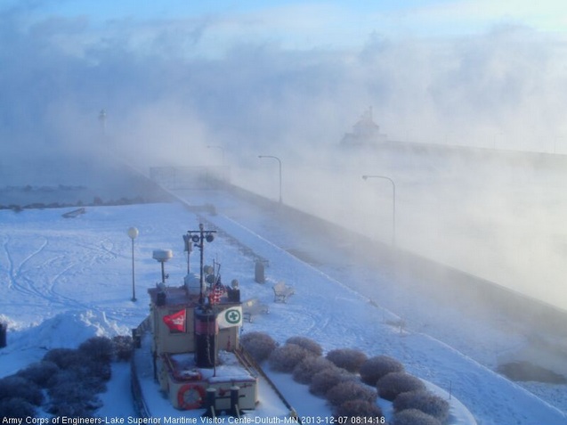
Here's a closer view of the lake steam from the Lake Superior Marine Museum:
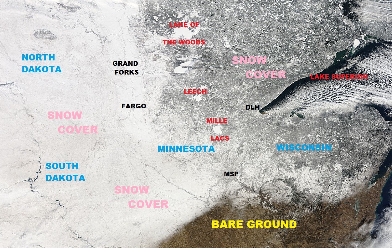
Arctic Sunshine
One thing about Arctic air is that it it very dry! The result tends to be sunny skies. Take a look at the satellite image from Friday, December 6th from across the Upper Midwest and note the mostly white coating of snow on the ground. You can pick out certain features like cities, lakes, rivers and even lake effect snow bands on Lake Superior; COOL! Also note the bare ground from extreme southeastern Minnesota to southern Wisconsin. Sunday's snowfall in those areas should take care of that though.
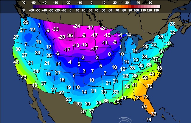
Lows AM Saturday
Thanks to a large dip in the jet stream, modified Arctic air has pushed through much of the nation. Temperatures are running well below average in many areas with double digit lows across the far north. Take a look at how cold it was early Saturday morning across the north-central U.S.
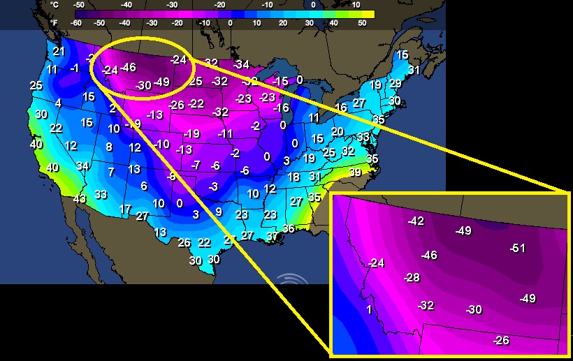
AM Saturday Wind Chills
Here were some of the lowest wind chills values that I could find AM Saturday. Note the near -50F wind chills across parts of Montana!
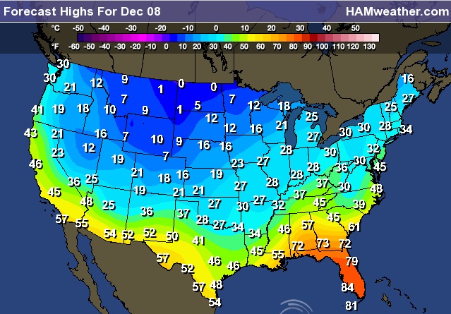
More Cold Weather Ahead
Daytime high temperatures on Sunday won't be much better than what we've been dealing with. The colder, heavier Arctic air is having a tough time getting out of the Lower 48. I liken cold air to syrup that you put on your pancakes... It's very heavy and dense, so trying to push it out can be tricky, especially if there's snow on the ground, because that's cold too!
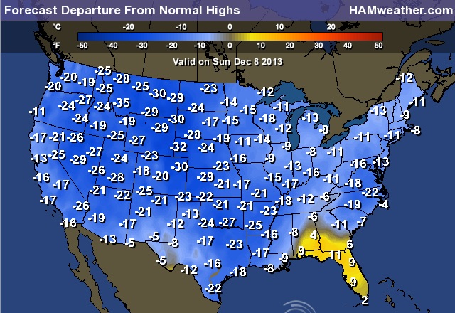
Highs From Normal Sunday
This map is pretty remarkable! Look at how cold much of the nation is. Not only is most of the nation colder than average, but most locations are in the double digits below average for high temperatures - YIKES! Heavy to Florida is you want some warmth.
Cold Threatens Orange Crop in California
Take a look at the low temperatures expected AM Sunday for parts of California - YIKES!
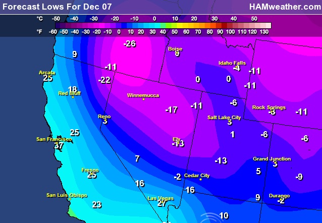
A number of Frost/Freeze headlines have been posted through early next week!
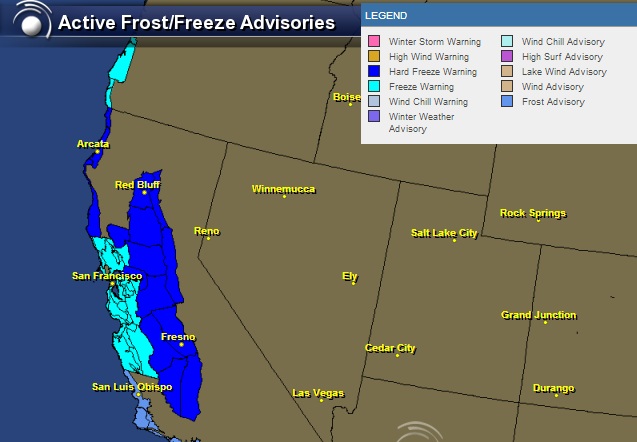
California Oranges
The much below average temperatures are even having an impact on the orange crop in California!
"Some damage is expected to the mandarin and navel orange crops in the Central Valley but the extent is still unknown. Any losses likely won't be known for several weeks, though the industry does not expect a dramatic impact on supply or price, according to California Citrus Mutual, an association of growers."

U.S. Snow Depth
It's a new snowy benchmark for the season. As of Saturday, 55.5% of the nation had snow cover! Impressive amounts of early December cold have pushed the storm track way to the South. You can actually see our last winter storm path from Texas to the Northeast. Significant amounts of freezing rain, sleet and snow made for major headaches and nasty travel weather. Unfortunately, there's still another system that will be heading into some of the same areas through the end of the weekend/early next week.
Snow Cover Last Year - 2012
Interestingly, at this time last year there was only about 10% of the nation covered in snow!
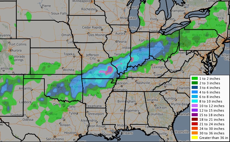
Snowfall Analysis
Here's the snowfall analysis from late last week, which show a narrow band of heavier snowfall from Texas to the Ohio valley. Note the nearly 10" to 12" amounts from southeast MO, to southern IL to southwest IL!
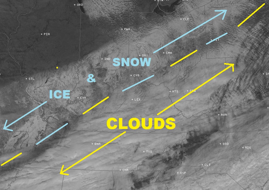
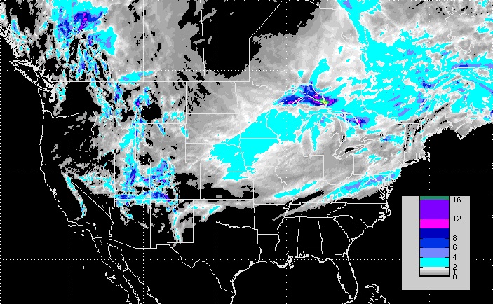
Visible Satellite
On a side note, you can actually see the snow/ice on the ground from satellite! The visible satellite image from midday Saturday showed a narrow band of it from SE Missouri to Indiana and Ohio. The dashed blue and yellow line is the dividing line between clouds and snow.
More Wintry Weather on the Way!
Unfortunately, we have another storm system quickly moving out of the western U.S.. The storm track has the system near the Great Lakes Region already by late Sunday night/early Monday morning. Like the last one, temperature profiles in the lowest mile of the atmosphere will be ever critical and it appears we'll have more freezing rain, sleet and snow potential in some of the same areas that got hit a few days ago.
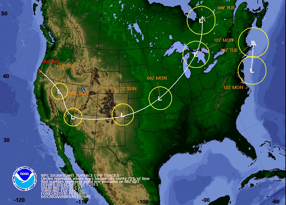
Next Winter Storm
National Weather Service offices across the country are still pretty busy this weekend. There are a number of winter weather headlines from cold to snow and ice, much of the nation will experience something as this system crosses the nation.
See more on the latest NWS watches/warnings/advisories HERE:
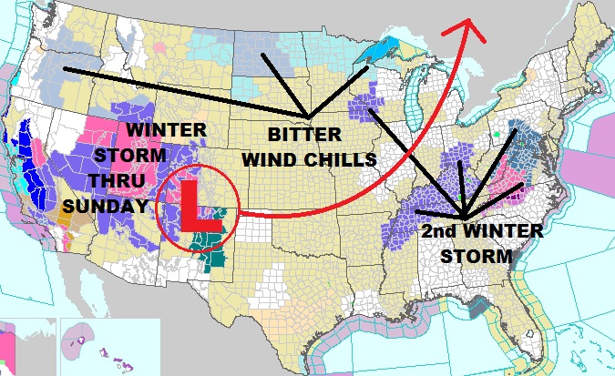
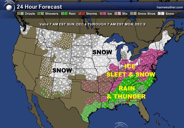
Sunday Weather Outlook
From rain/thunder to freezing rain, sleet and snow. This storm system will have a big impact on a large number of people through Sunday. The most concerning part to the storm will likely be from the middle Mississippi Valley to the Mid-Atlantic region where a mixed bag of wintry precipitation will be found. Ice, then snow could make for some major headaches!
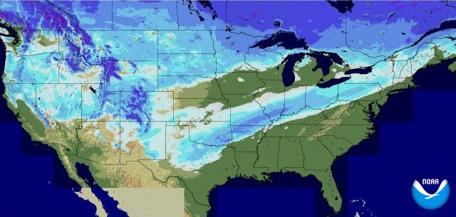
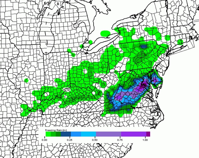
More Ice
The temperature profile over parts of the Ohio valley and the Mid-Atlantic Region don't look good. In fact, it looks pretty ugly on Sunday, where more freezing rain is possible. Here's a look at the freezing rain potential thru AM Monday. Keep in mind that the amounts projected below are likely too high for what atmospheric conditions will actually produce. I could reasonably see around 1/4" to 1/2" in some areas, which would certainly be enough to cause power outages and major travel headaches!
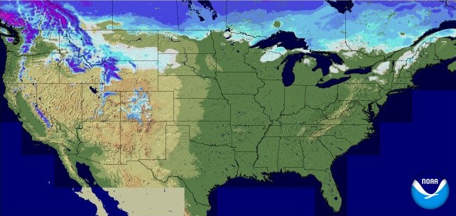
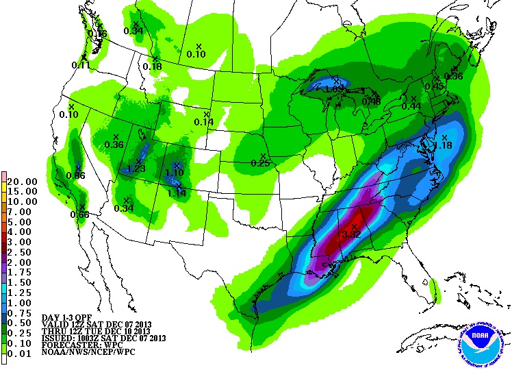
Snow Potential
As our next storm system crosses the nation, plowable snow amounts will once again be possible from areas in the West to the Midwest and once again across parts of the Ohio Valley east to the Mid-Atlantic. Don't put away the shovels just yet. The image below suggests the snowfall potential thru AM Tuesday.
Precipitation Outlook
Another round of heavy precipitation looks like it will set up aross parts of the Ohio Valley and the Tennessee Valley through early next week with up to 3" or more possible.
Thanks for checking in and have a great rest of your weekend!
Don't forget to follow me on Twitter @TNelsonWNTV

No comments:
Post a Comment