29 F. high in the Twin Cities Monday.
30 F. average high on February 17
32 F. high on February 17, 2013.
15" snow on the ground in the Twin Cities.
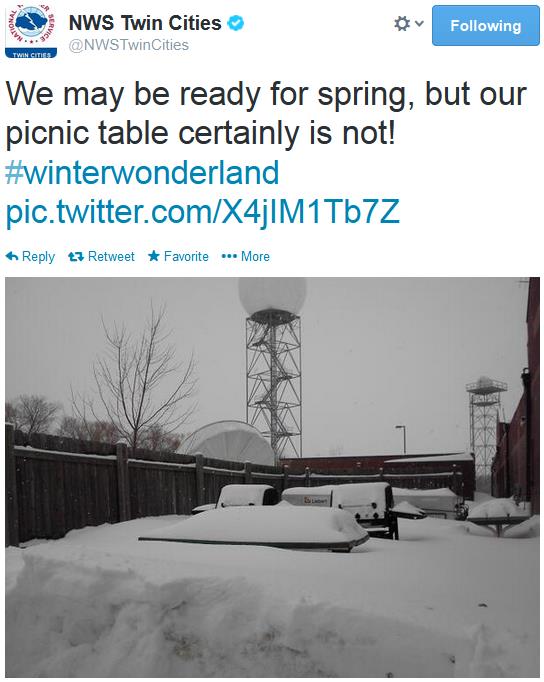
4.9" snow fell yesterday, a new 24 hour snowfall record. Second biggest snowfall of the winter for MSP.
47.1" snow so far this winter (8.7" above average, to date, and 16" more than we had seen as of February 17, 2013).
43rd snowiest winter since 1873 in the Twin Cities, to date.
Finally: Hints of March
Well,
at least snow lovers are content. Not nearly as many (flaming) e-mails
from irate snowmobilers wondering where to drive their sleds to see
snow. That's an improvement.
An extended stay from the Polar
Vortex is treating the continental U.S. to the coldest winter since
1979; the 3rd coldest on record, to date. A real winter. The same
stagnant, mostly-stalled jet stream is sparking record drought across
California, biblical storms for Britain, a springlike February across
Europe - along with shirtsleeves & surplus slush for Sochi, Russia.
For
the first time in 20 days we surge above 32F today. Some towns may see
the first 40F high since January 12. A poignant reminder of a higher sun
angle, making it harder to get extreme, school-closing cold fronts by
late February.
Lows slip below zero again early next week, but it
won't be anything like January's Siberian Smack. Enjoy a partial thaw
into Thursday, but keep heavier coats handy for the weekend. No big
snows brewing; cold air from the weekend into much of next week will
push the storm track well south of Minnesota. Some light accumulation is
possible Thursday - maybe a couple inches.
Kent from Eden Prairie
writes: "Hey Paul, I witnessed at least 10 fat robins in the midday sun
hopping from branch to branch under a marvelous blue sky. Are these
birds crazy and confused?"
Yep. Join the crowd.
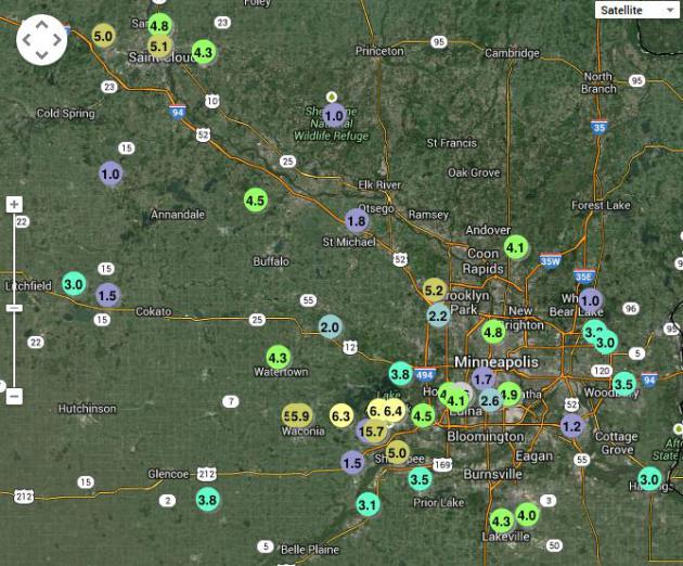
Monday Morning Amounts.
Some clipper-like storms are more fickle than others. Yesterday's snow
burst dumped nearly half a foot of snow from near Lake Minnetonka and
Shakopee westward to Waconia, while White Bear Lake reported 1", 3.5" at
Woodbury and 2-5" for the downtowns. The latest amounts from the Twin
Cities NWS are
here.
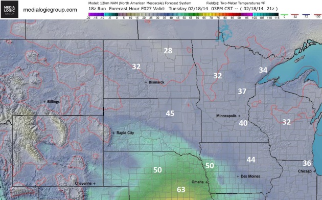
Bring Out Your Dead!
O.K. If you're not a Monty Python fan you probably think I've lost my
mind, which, under the circumstances, is quite possible. Maybe ring the
church bells? More PC. If nothing else go ahead and exhale - for the
first time in 20 days the mercury should rise well into the 30s to near
40F, in spite of the 15" snow on the ground in the Twin Cities. 3 pm 2
meter NAM predicted temperatures courtesy of NOAA and Ham Weather.
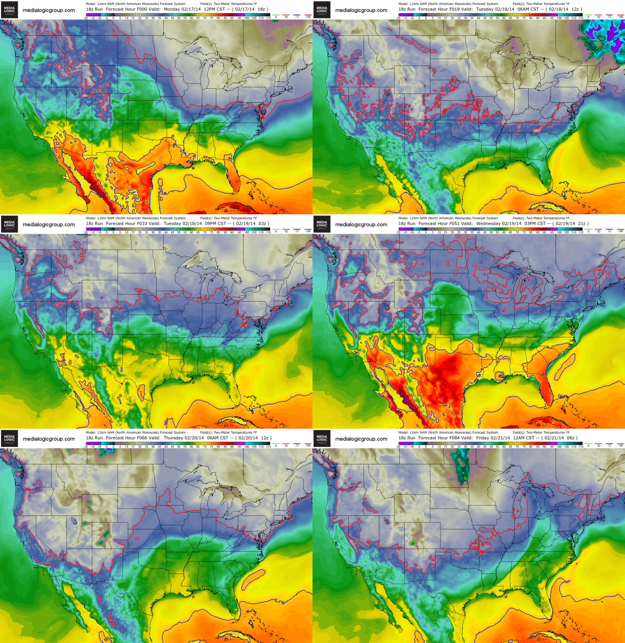
A Precious Puff of Pacific Air.
Canadian air will be in full retreat, at least for the next 48-72 hours
as a more westerly kink in the jet stream blows milder air across the
USA. The solid red line marks the 32F isotherm, which pushes as far
north as Duluth and Grand Rapids, Michigan in the coming days. 50s
stream up the East Coast by Friday ahead of the next cold frontal
passage.
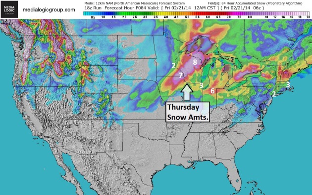
84-Hour Snow Potential.
Thursday's storm system may drop another plowable snow from northern
Iowa into southeast Minnesota and much of Wisconsin. It's still early to
be assigning inch-amounts, but if you're traveling into the Upper
Midwest late Wednesday into Thursday you may run into some slushy
delays. 2-4" of snow may drop on New York City and Boston this morning, a
taste of spring in the air by late week. NAM snowfall numbers: NOAA and
Ham Weather.
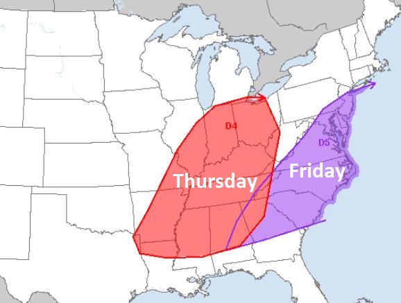
A More Ominous Sign of Spring. NOAA SPC (
Storm Prediction Center)
is predicting a slight risk of a severe weather outbreak from near
South Bend to Memphis and Little Rock Thursday, shifting to the East
Coast by Friday - with enough low level moisture, wind shear and
instability to support supercell T-storms capable of large hail,
straight-line wind damage, even an isolated tornado. What's ironic is
that there's still snow on the ground over much of the Ohio Valley. Talk
about weather whiplash.
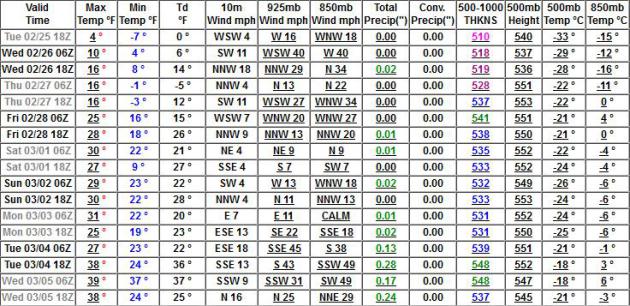
European Numbers.
Highs should rise up 32F each afternoon into Thursday, followed by a
cooling trend by late week, a couple more subzero lows possible early
next week. Cold, but not school-closing cold. Graph: Weatherspark.
Evidence Of A Higher Sun Angle.
We'll see more cold fronts (take it to the bank), but the odds of
subzero daytime highs drop rapidly as we enter March - the sun is just
too high in the southern sky for the level of cold we saw in January and
even early Febraury. GFS numbers shows 30s the first 5 days of March,
even a shot at 40F. That would be nice.
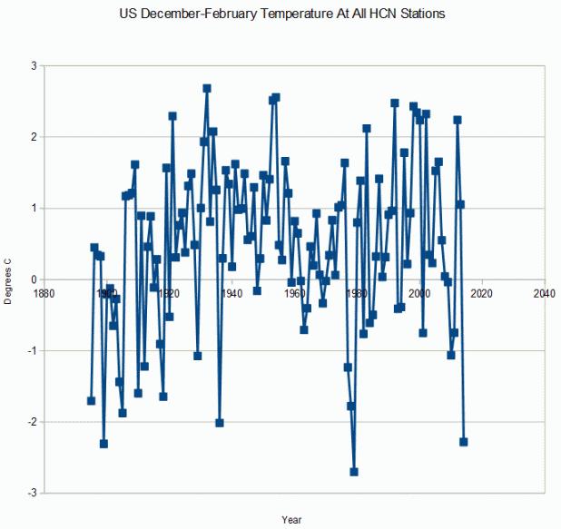
Third Coldest U.S. Winter On Record For USA? Here's an excerpt from
Steven Goddard: "
If February ended today, this would be the third coldest winter on record in the US, after 1979 and 1899."
The Winter of All or Nothing.
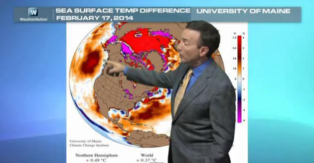
Flood or drought, record warmth or record chill? A stalled kink in the
jet stream steering winds is creating chaos and unusual anomalies of
moisture and temperature across the Northern Hemisphere; the topic of
today's
Climate Matters: "
WeatherNationTV
Chief Meteorologist Paul Douglas goes over the historically cold
meteorological winter the Lower 48 has been experiencing. Lots of snow,
lots of ice, and bone chilling temps were all par for the course this
winter. But Spring is around the corner! Just because the US has been
cold, what has the temperature trend been around the globe? Find out
what a stuck jet stream has to do with it all."
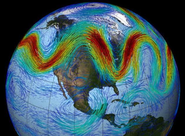
Warming Arctic May Be Causing Jet Stream To Lose Its Way. Echoing trends I've been seeing since roughly 2010-2011,
NPR
reports on how changes in far northern latitudes may be showing up in
the skies floating above your house; here's an excerpt: "...
The
temperature difference between the Arctic and lower latitudes is one of
the main sources of fuel for the jet stream; it's what drives the winds.
And because the Arctic is warming so fast, that temperature difference
is getting smaller, and so the fuel for the jet stream is getting
weaker," Francis says. "When it gets into this pattern, those big waves
tend to stay in the same place for some time. The pattern we've seen in
December and January has been one of these very wavy patterns..."
Image credit above: "
The
jet stream that circles Earth's north pole travels west to east. But
when the jet stream interacts with a Rossby wave, as shown here, the
winds can wander far north and south, bringing frigid air to normally
mild southern states."
NASA/GSFC.
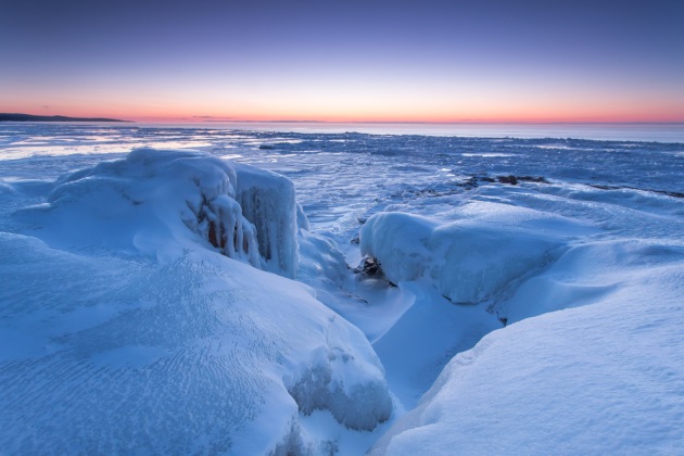
A Surplus Of Ice.
Photographer Steve Burns captured this remarkable photo of the
ice-covered North Shore of Lake Superior Sunday morning. Check out his
gallery
here.
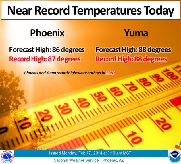
Chest-Thumping Warmth Across Arizona.
Are you hearing anything from your long-lost friends down in Phoenix,
Scottsdale or Tucson? Expect a call, text or tweet, because near-record
warmth continues. Must be nice. Graphic: Phoenix office of The National
Weather Service.
At Sochi Olympics, Finding Risk Is Snow Problem.
No shortage of lukewarm slush on the slopes of Sochi. In the city of
Sochi itself there are days when I ask myself "Winter or Summer
Olympics?" Here's an excerpt from
The Washington Post: "
The
snow around here looks like soup, a creamy bisque that seems harmless
enough until the athletes plunge into it and find the hard crags of the
Caucasus beneath, which is when the medics race out. The sounds of the
Sochi Games are a whack and the clatter of boards and skis, followed by
wails — or worse, a terrible stillness. The mounting crash toll includes
a broken back, a broken jaw and an assortment of head injuries. The
logo for this Olympics ought to be a stretcher..."
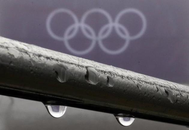
Photo credit above: "
Rain
drops hang on a railing at the 2014 Winter Olympics, Monday, Feb. 17,
2014, in Krasnaya Polyana, Russia. After days of warm weather at the
Sochi Olympics, fog up in the mountains is causing an even bigger
disturbance.Thick fog rolled in over the mountains in Krasnaya Polyana
on Sunday night and was still lingering on Monday, and the limited
visibility forced organizers to delay a biathlon race and cancel the
seeding runs in a snowboard event." (AP Photo/Kirsty Wigglesworth).
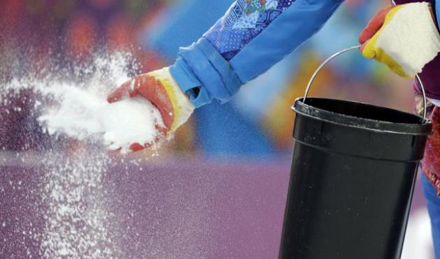
A Mad Dash For Salt Rescues Olympic Slopes. This sounds like the plot for a (bad) made-for-TV-movie of the week, but it's true. Here's an excerpt from
The New York Times: "...
Homeowners
use salt to melt ice on the sidewalk, but Alpine experts cleverly use
it to overcome soft snow conditions when a hard, icy surface is
preferable. The salt melts the soft snow, and when the temperature drops
— usually overnight — a layer of ice forms. Large-grain salt, about
five millimeters in size, is best for soft, deep snow, because it drops
farther into the snow and lasts for days, not hours..."
Photo credit above: "
A
referee throws salt on the track prior to the men's biathlon 20k
individual race, at the 2014 Winter Olympics, Thursday, Feb. 13, 2014,
in Krasnaya Polyana, Russia." (AP Photo/Lee Jin-man).
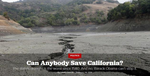
Can Anybody Save California? Politico has the article; here's an excerpt: "...
The
mega-drought is pitting farmers against fishermen, north against south
and, of course, Democrats against Republicans. But that’s frequently the
case in California, which has battled for more than a century over how
to allocate too little water for too many people. The dry landscape adds
another layer of rancor, and with the planet heating up and fueling
bigger, longer and more severe droughts, that’s likely to be a permanent
fixture. How state and federal lawmakers respond to the crisis could
offer a window into how the United States writ large will react to
climate events in real time—and so far, the politics appear too small
for the task..."
4 Sales Strategy Lessons From House Of Cards. Yeah, I'm hooked, up to Episode 12 of Season 2. Thank you Netflix. Here's an excerpt of a well-timed article from
LinkedIn that made me do a double-take: "...
Underwood
is known for his particularly ruthless political tactics, but he
ultimately gets his way through sheer determination. While we don’t
endorse any under-the-table dealings, sales professionals can still take
a few lessons from Underwood when looking to advance their goals. Keep
these 4 thoughts in mind when structuring your sales strategy:
1). Know (and grow) your network
In season one, Underwood served as the Democratic House Majority Whip under a new White House administration...."
Weird Weather - Minnesota's New Normal? This
evening I'll be talking about the trends I'm seeing in the data,
focusing on Minnesota and the Midwest, part of a broader educational and
informational overview on climate change. Doors open 6 PM Tuesday at
Eden Prairie High School; more details from Environment Minnesota, where
you can
RSVP: "
Our
climate is changing at an alarming rate. From giant hailstorms to polar
vortices, Minnesotans are already experiening extreme weather. Are
weird weather events becoming Minnesota’s new normal? On Tuesday,
February 18 join Environment Minnesota, Citizen’s Climate Lobby, and
Cool Planet to hear from nationally recognized meteorologist and
entrepreneur Paul Douglas for "Weird Weather: Minnesota’s new normal?
Our Changing Climate and What We Can Do About It."
TODAY: Icy start, slushy finish. Blue sky with hints of March. Winds: W 10. High: 39
TUESDAY NIGHT: Partly cloudy, cooling off slightly. Low: 19
WEDNESDAY: Chilly start, some PM drips. High: 36
THURSDAY: Cloudy, couple inches of slushy snow? Wake-up: 29. High: 33
FRIDAY: Mostly cloudy, colder wind. Wake-up: 16. High: 23
SATURDAY: Intervals of sun, still chilled. Wake-up: 4. High: 18
SUNDAY: Some sun. Praying for spring. Wake-up: 1. High: 16
MONDAY: Brisk. Storms detour south of Minnesota. Wake-up: 3. High: 12
Climate Stories....
While Britain Floods, Politicians Debate Climate Change.
Time Magazine
has a good overview of historic flooding gripping the U.K., and how
it's unleashed a political firestorm of debate. Here's a clip: "
Britons
are normally never more comfortable than when talking about the
weather, but recent extreme weather events have began to test that
theory. Since December, the U.K. has faced a relentless assault from
some of the worst winter weather on record. It began with the worst
storm and tidal surges in 60 years hitting the North Sea coastline,
floods that ruined Christmas for thousands across Surrey and Dorset and
in January, the most exceptional period of rainfall since 1766. The
deluge has transformed swathes of southern England into cold, dark
lakes, destroying homes and businesses, and in some cases taking lives..."
Photo credit above: "
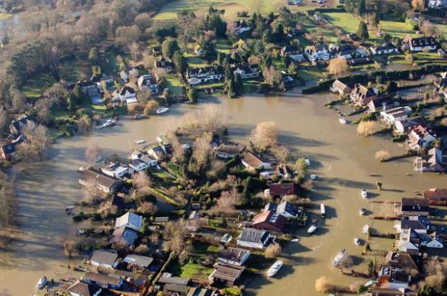
Flood
water surrounds homes in Shepperton, Surrey, England, as Royal
Engineers are now being tasked to carry out a high-speed assessment of
damage to the UK's flood defense infrastructure, Sunday, Feb. 16, 2014.
The military could have been brought in earlier to help deal with the
winter storms that have been wracking Britain, a Cabinet minister has
admitted. As the weather finally gave the country a respite, Defence
Secretary Philip Hammond defended the Government's handling of the
crisis." (AP Photo/PA, Steve Parsons).
More Heat Is Going Into The Ocean. Really.
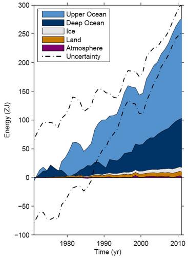
The experiment continues, and we're not really sure how the deep-ocean
heating will manifest itself with weather. Here's an excerpt of a post
from
Simon Donner: "
You may have heard climate scientists, myself included,
state that “global warming” has indeed continued with little
interruption over the past 10-15 years, but that more of the heat
trapped in the climate system by greenhouse gases has been “going into
the ocean”. This is not the rhetoric of irrational climate alarmists.
This is what the measurements show. The human enhancement of the
greenhouse effect has reduced the outgoing radiation to space and increased the energy content of the climate system, as is shown on the graph (above)...."
Graphic credit above: "
Change in energy content of different components of the climate system." (IPCC, 2013).
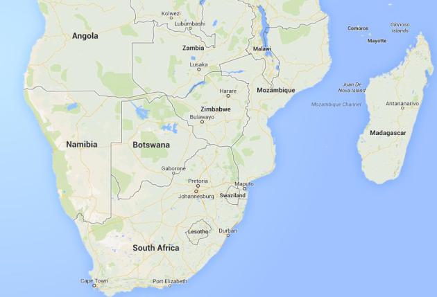
You Don't Have To Live On A Coast To Get Flooded Out By Climate Change. The African nation of Zimbabwe is experiencing record floods; here's an excerpt from
Grist: "...
The crisis has prompted the country’s leaders to plead for international aid. They are asking for $20 million of assistance to evacuate more than 2,000 families living
downstream from the Tokwe-Mukorsi dam, which is so overladen with water
that experts fear it is about burst. Such floods may be a symptom of
climate change, which is also ravaging the impoverished country with rising temperatures and increasingly frequent droughts..."
Map above: Google Earth.
Featuring Skeptics In News Media Stories Reduces Public Beliefs In The Seriousness Of Global Warming. Here's an excerpt of a summary of a study from
Stanford University: "
News
media coverage of global warming has often offered “balanced” accounts,
quoting mainstream scientists and skeptics in the same story. Balanced
accounts might be considered admirable efforts to abide by the
journalistic norms of objectivity and fairness.However, critics have
noted that balanced reporting of this particular issue actually conveys a
misleading portrait of the science of climate change, since scientists
endorsing the mainstream view appear to outnumber skeptics.Our study
explored the impact of including skeptical voices in news media
coverage. In particular, we explored whether adding a skeptic to a story
about a mainstream scientist’s views or findings would reduce the
number of people who perceive agreement among scientific experts on this
issue and think global warming is a serious problem..."
Viewpoints: Fracking During The Drought Is Destructive and Irresponsible.
The Sacramento Bee has an Op-Ed that caught my eye; here's a clip: "...
Fracking
is a triple threat to California’s water. Not only does it exacerbate
the climate crisis, it requires mixing vast amounts of water with
harmful chemicals, and it puts our vital aquifers at risk of
contamination for generations. Last week, the green investment group
Ceres released a report that found that 96 percent of fracking wells in
California were drilled in regions under high or extremely high water
stress..."
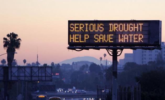
Photo credit above: "
This Feb. 14, 2014
photo shows a freeway sign in Los Angeles advising motorists to save
water because of the state's severe drought. This week the California
Department of Transportation launched an education campaign with 700
electronic highway boards displaying the message: "Serious Drought. Help
Save Water."



No comments:
Post a Comment