By Todd Nelson
Hey, guess what... Meteorological Winter ends in a little more than 2 week! March 1st will mark the date when the coldest 3 months (on average) are behind us and it seems as if it's only an arm's reach away. We will likely encounter a few wintry spats between now and the official start to Spring, which is March 20th, but the worst of the winter weather may be deteriorating.
Today will bring another snow chance to the Upper Midwest with the heaviest snowfall potential sitting across far northern Minnesota. There will be a quit shot of cold exhaust on the back side of this quick moving clipper system, but the face numbing cold air will start to erode by the weekend.
The warming atmosphere will squeeze out a couple more clipper systems over the weekend with light snow possible both days, but the prize arrives into next week as we finally thaw out! By the way, the last time we had a daytime high in the 20s was February 1st and the last time we had a high temperature in the 30s was back on January 29th, 2 weeks ago.
The extended forecast calls for a string of 30s next week! It'll feel better out there, but it's going to get a little sloppy. #PuddleWeather
______________________________________________________________
WEDNESDAY NIGHT: Another clipper arrives with a light snow chance. Low: 14. Winds: S 5-15.
THURSDAY: A little light snow early. Turning breezy and cooler late. High: 30. Winds: NW 10-20.
THURSDAY NIGHT: Mostly cloudy and colder. Low: 0. Winds: NW 10-15
FRIDAY: Minor setback in the temperature department. High: 12.
SATURDAY: Light snow chance. Wake-up: -1. High: 18.
SUNDAY: Warming, wintry mix late. Wake-up: 8. High: 26.
MONDAY: Mix early, then gradual clearing and warmer! Wake-up: 22. High: 34.
TUESDAY: More sun and still mild. Wake-up: 15. High: 34.
WEDNESDAY: Continued thaw. Sprinkles? Wake-up: 25. High: 36.
_______________________________________________________________
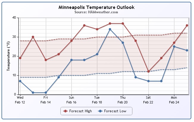
Minneapolis Temperature Trend
After a brief shot of cooler air on Friday, the temperature trend looks pleasing into much of next week! Note how we see a string of 30s before a possible secondary shot of cold weather next Saturday. The important thing to note with this is that the wintry sptats don't seem to be sticking around for quite as long as they did in January or early February! We might be starting to see the demise of the extreme Arctic air close to home!
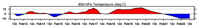
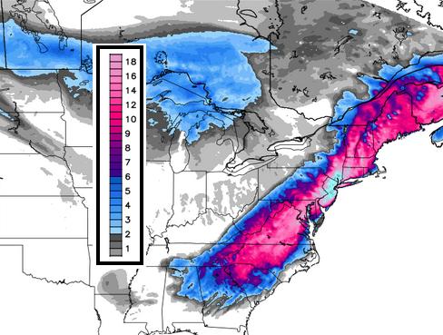
850mb Temperature Trend
Here's the temperature trend for the 850mb level, which is a few thousand feet off the ground. Note the red colors showing up into next week. This indicated temperatures warming at this level and is a good indicator of how temperatures may respond at the surface.
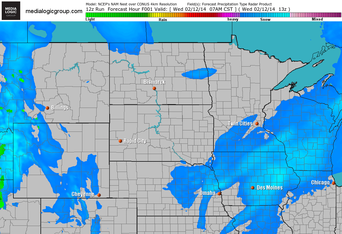
FutureRadar
Fast moving clippers systems continue to roll through the Upper Midwest. Each one will be responsible for light snow chances as they quickly move south.
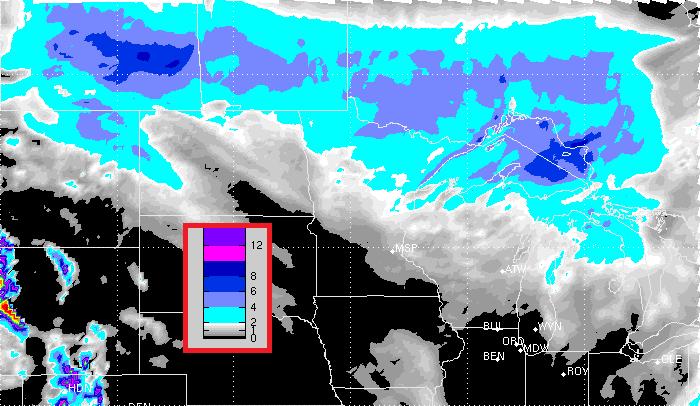
Snow Chances Continue
Here's the snow potential through Saturday, which shows a better chance of accumulations across far northern Minnesota.
Major Snow & Ice Event
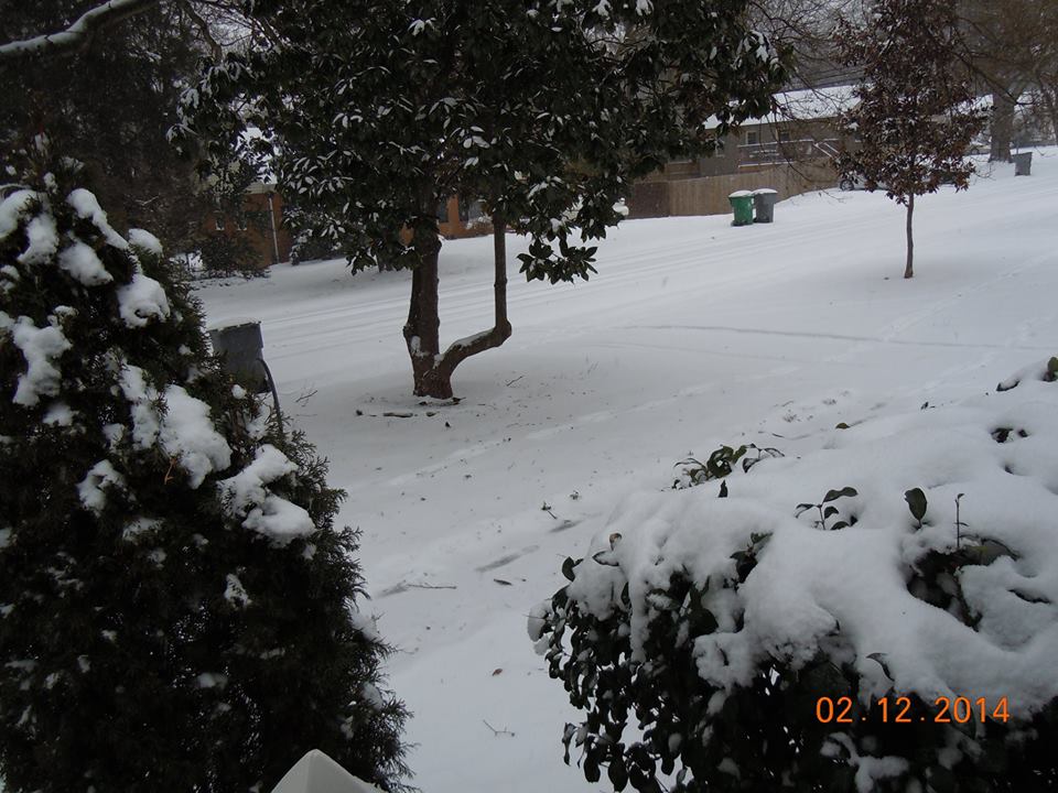
Thanks to @M_Benson06 out of Moncks Corner, SC for the picture below. Unfortunately, this was an all too familiar scene in many spots across the Southeastern part of the nation.
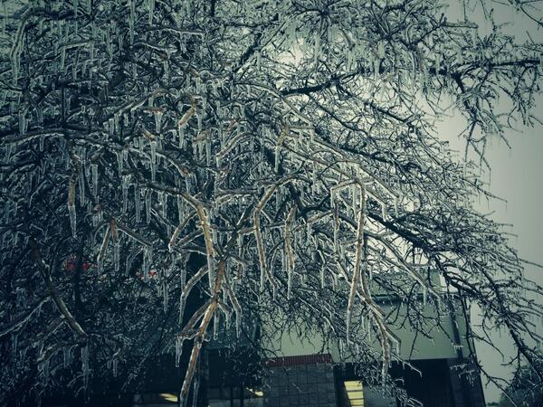
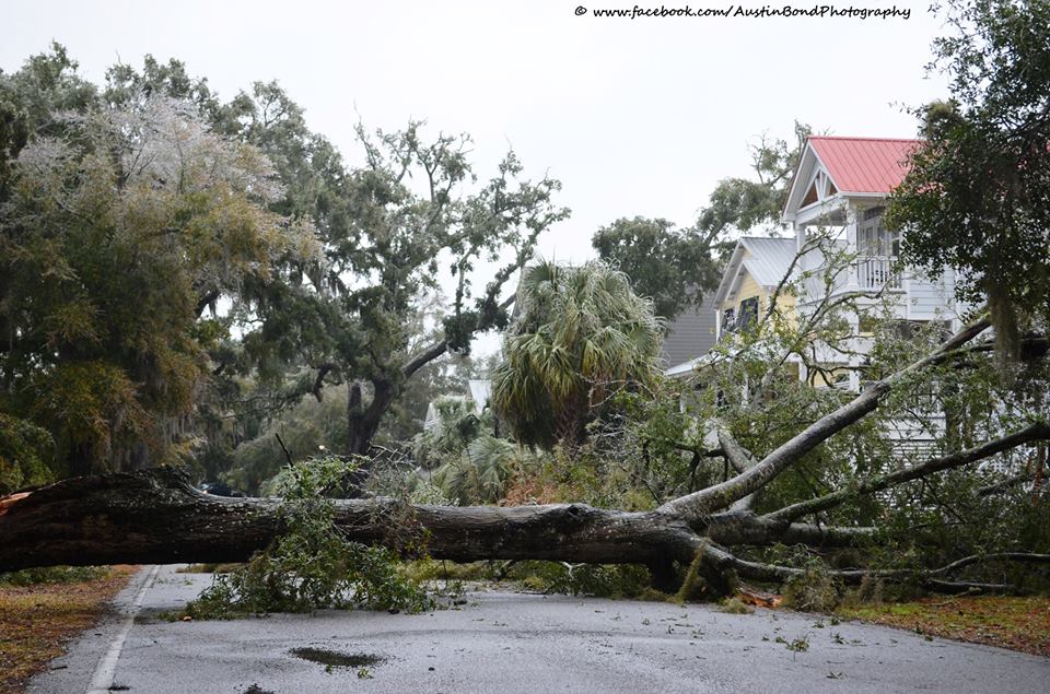
Murrells Inlet, SC
Thanks to Austin Bond Photography for this picture. The ice was too much for this tree... YIKES!
"Live Oak Tree down on Belin Drive in Murrells Inlet, SC today due to ice storm. Many large branches are falling from the trees in the woods surrounding Belin UMC's cemetery. Approximately one large branch every five minutes. This ice storm doesn't seem as much ice as the last one but the trees are having a tough time here! Please share and be careful out there!"
See more HERE:
Augusta, Georgia
Thanks to The Augusta Chronicle for this image out of Augusta, GA where the weight of the ice on trees unfortunately led to many of these images. With downed trees comes downed power lines and the big issue over the next several days is going to be restoring power to those who have lost it.
See more HERE:
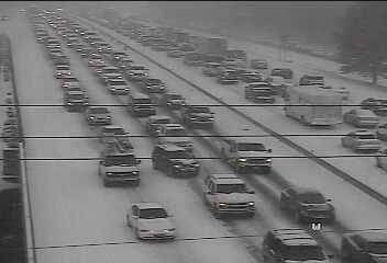
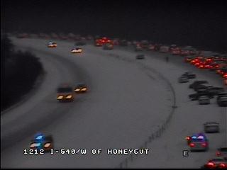
Reminiscent of Atlanta 2 Weeks Ago
Thanks to NCDOT for the image below, which showed the traffic situation from around the Raleigh-Durham, NC region yesterday afternoon/evening. It's very reminiscent of what happened a couple of weeks ago in Atlanta, GA
Charlotte, NC Snow
Thanks to Bobbi Marshall Sundeen for this picture out of Charlotte, NC
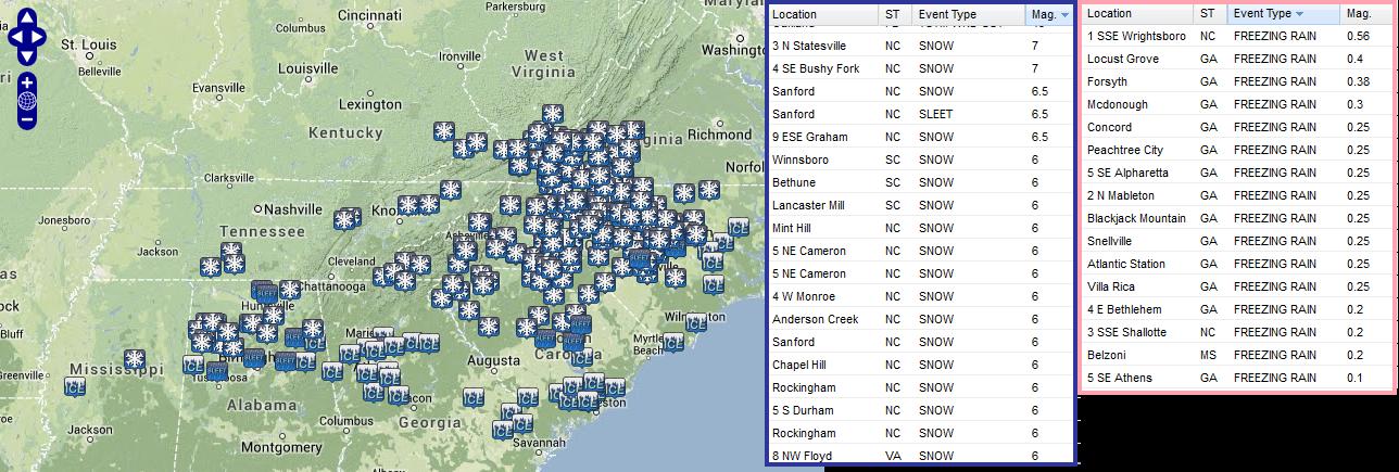
Ice & Snow Reports
This is a look at some of the ice and snow reports that came in as of early evening from the southeastern part of the country. Unfortunately, the storm will continue to pump out ice and snow reports through Friday.
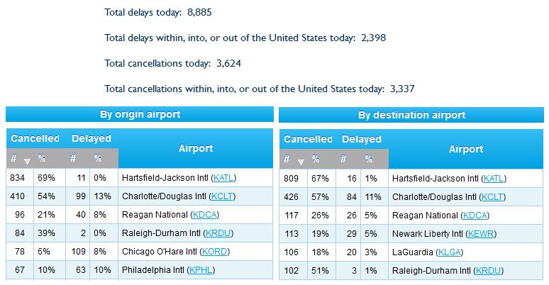
Flight Cancellations Wednesday
Another slow/frustrating day at the airports. Take a look at how many flights were either delayed or canceled on Wednesday. More than 3,000 flights were canceled across the U.S. while nearly 1,600 of those flights being canceled to or from the Atlanta airport.
See the latest flight delays/cancellations from FlightAware.com HERE:
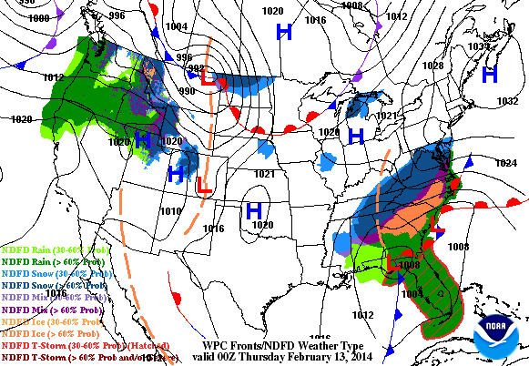
Storm Churns Up the Coast
This powerful storm system will continue to intensify as it lifts northeast along the coastline. The biggest threat heading into the end of the week will be significant snow tallies.
Here's more from NOAA's Weather Prediction Center:
THE LOW PRESSURE SYSTEM IS EXPECTED TO INTENSIFY AND WILL BEGIN TO MOVE NORTHEASTWARD UP THE EASTERN SEABOARD IN THE NEXT COUPLE OF DAYS. WITH COLD AIR IN PLACE NEAR THE GROUND WHILE WARM AIR ALOFT BEING DRAWN INTO THE INTENSIFYING STORM FROM THE ATLANTIC...CONSIDERABLE AMOUNT OF ICE ACCUMULATIONS OF OVER ONE INCH WILL BE POSSIBLE FOR PORTIONS OF NORTH-CENTRAL GEORGIA AND SOUTH CAROLINA...WITH A LITTLE OVER HALF AN INCH OF ICE OVER CENTRAL NORTH CAROLINA. MEANWHILE...SNOW IS EXPECTED ALONG THE NORTHERN EDGE OF THE PRECIPITATION SHIELD TONIGHT ACROSS EXTREME NORTHERN MISSISSIPPI...ALABAMA...AND GEORGIA AS WELL AS TENNESSEE WITH 1 TO 4 INCHES EXPECTED. HEAVY SNOW IS EXPECTED TO SPREAD NORTHWARD INTO THE SOUTHERN APPALACHIANS...WITH SNOWFALL AMOUNTS 10 TO 14 INCHES EXPECTED FROM EXTREME NORTHERN GEORGIA AND SOUTH CAROLINA NORTHWARD ALONG AND JUST EAST OF THE HIGHER TERRAIN OF THE APPALACHIANS IN NORTH CAROLINA...TENNESSEE...AND SOUTHERN VIRGINIA BY THIS EVENING. HEAVY SNOW WILL CONTINUE INTO THE MID ATLANTIC AND NORTHEAST THIS EVENING AND THURSDAY WITH SIGNIFICANT ACCUMULATIONS OF 10 TO 15 INCHES POSSIBLE. CLOSER TO THE COAST...WARMER AIR FROM THE ATLANTIC IS EXPECTED TO CHANGE THE SNOW TO A WINTRY MIX OR ALL RAIN.
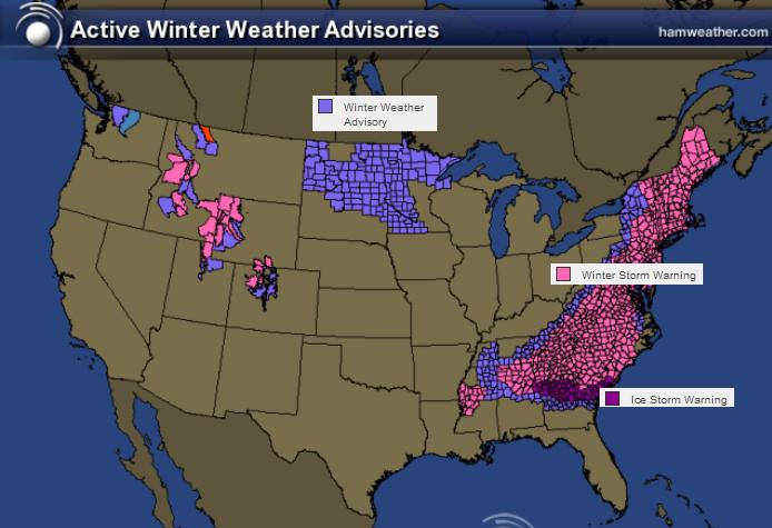
Winter Weather Concerns Continue
Winter weather headlines have been posted all the way up the Eastern Seaboard to the Northern New England States. The major icing threat will begin to fade AM Thursday, but heavy snow will be the biggest concern through Friday.
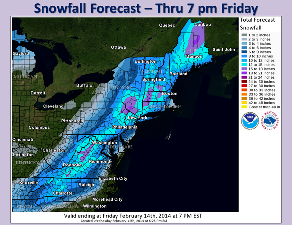
Snowfall Potential
There is going to be a fairly extensive snow swath along the Eastern Seaboard through the end of the week. Some areas could walk away with 6" to 12"+ by the time this is all said and done.
Here's a look at snowfall tallies from the National Weather Service Eastern Region Headquarters.
See more HERE:
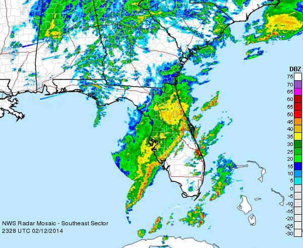
Wednesday Severe Weather
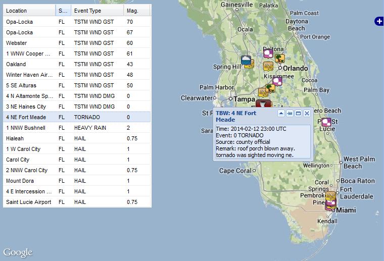
If the wintry weather wasn't enough, we even had severe weather issues across parts of Florida on Wednesday. This was the radar across Florida on Wednesday afternoon.
Florida Tornado
The storm reports from Wednesday showed a tornado report near Fort Meade in central Florida where a tornado reportedly blew the roof off of a porch.
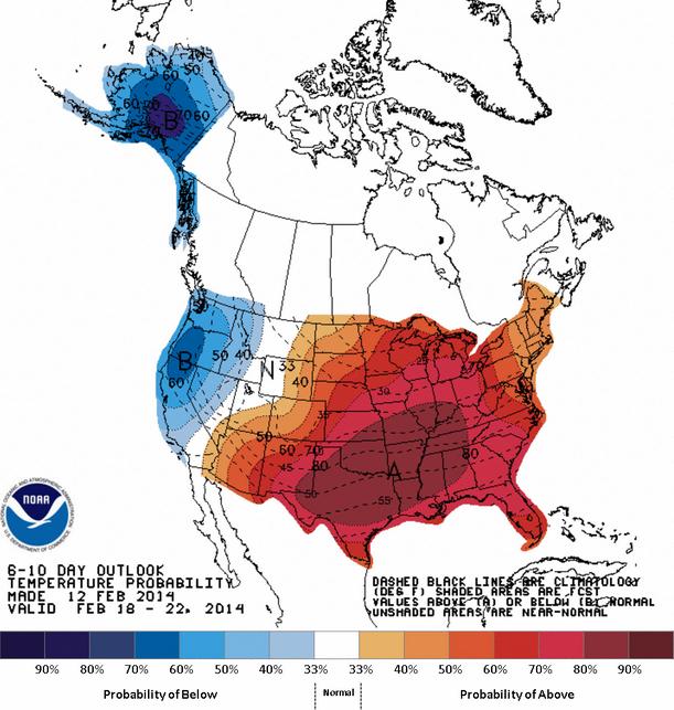
Warmer Weather Ahead
According to NOAA's 6 to 10 day temperature outlook, which will take us through next week. It appears that the eastern two-thirds of the nation will be warmer than average. The good news is that much of the snow and ice that has fallen in the deep south will melt quickly! This should help power crews with the upcoming task of restoring power to all the customers that have lost their power.
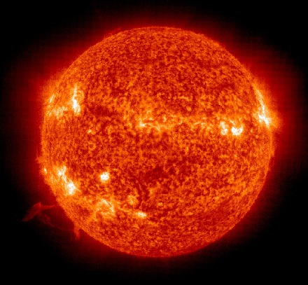
Valentine's Day Northern Lights Potential?
NOAA has issued 2 Solar Storm Watches! The potential for northern lights viewing may be increasing for northern dwellers.
"The National Oceanic and Atmospheric Administration (NOAA) Space Weather Prediction Center has issued two consecutive 24 hour magnetic storm watches indicating a Coronal Mass Ejection (CME) emanating from the Sun may be heading towards Earth. A CME is a fast moving cloud of charged particles which can cause a Northern Lights display."
See more information from www.SoftServeNews.com HERE:
Thanks for checking in and have a great rest of your week!
Don't forget to follow me on Twitter @TNelsonWNTV

No comments:
Post a Comment