16 F. high in the Twin Cities Friday.
29 F. average high on February 14.
34 F. high on February 14, 2013.
13" snow on the ground in the Twin Cities.
40.4" snowfall so far this winter at KMSP.
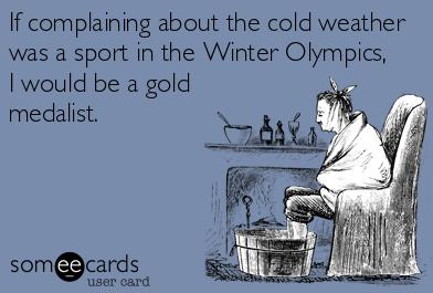
Olympic Daydreams
I wonder if I'd get any points from Olympic judges for just skating in a sloppy circle, waving at the crowd? Better yet, pick a person at random from the stands to "compete" in each event. For some perspective. It's a wonder I'm not in charge of programming at NBC Sports.
We've had our own Winter Games: 44 subzero nights - most since 1981-82; coming off a stretch of 17 subzero nights in a row. That's the 8th longest subzero streak in Twin Cities climate records, according to Dr. Mark Seeley.
Since 2010 I've been telling you that something has changed with the jet stream. It may be related to summer ice melt in the Arctic (too early to know) - but the weather, increasingly, is getting stuck. The same persistent block responsible for our stubborn Polar Vortex is creating historic drought across California and strafing Britain with a parade of record floods.
A weak clipper may brush us with an inch of snow today; a few more inches Monday - again next Thursday. By the middle of next week highs approach 40F.
There is hope in the extended outlook.
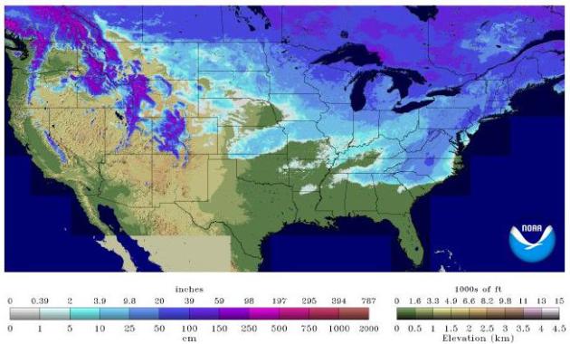
It could always be worse. Chicago has picked up 62 inches of snow this winter. Central Park (New York City) is up to 54". Here in the Twin Cities? A mere 40.4 inches...and counting.
* 88% of the Great Lakes are ice-covered, the most since 1994, when 94% of the lakes were frozen. Details here.
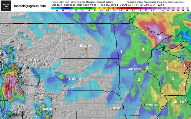
Additional Snowfall By Tuesday Morning.
A dusting or coating is possible today, with a better chance of an inch
or two of snow Sunday night into Monday morning - heavier amounts
closer to Dubuque, Madison and Green Bay. Grand Marais may pick up as
much as 8" of snow. NAM guidance: NOAA and Ham Weather.

Ring The Church Bells.
The last time the Twin Cities saw freezing? 34F on January 29. We're
due for a thaw, and it's coming next week, with 3 days above freezing,
followed by a slight cooling trend the end of next week. A higher sun
angle is (finally) starting to show up on the weather maps. Graph:
Weatherspark.

Below Zero Nights Ending? We can only hope and pray. Here's an excerpt from Dr. Mark Seeley's latest edition of Minnesota WeatherTalk: "For
the Twin Cities the count of nights with 0 degrees F or lower
temperatures stands at 44 for the current winter season (since December
1st), the most since the winter of 1981-1982. A string of 17 consecutive
days with minimum temperatures of 0 degrees F or lower was observed
from January 26 to February 11, the 8th longest such streak in the Twin
Cities climate records...Some other counts of days with 0 degrees F or colder this winter for other cities include:
Duluth 58 days (most since 1964-1965)
Rochester 42 days (most since 1978-1979)
International Falls 65 days (most since 2008-2009)..."
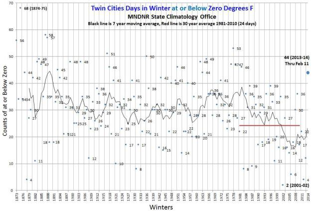
Days At Or Below Zero In The Twin Cities. More perspective on subzero fun at MSP from the Minnesota DNR; here's an excerpt: "...How
does the winter of 2013-14 stack up for counts of minimum temperatures
at or below zero in the Twin Cities? As of February 11, there have been
44 minimum temperatures of zero or colder: 13 in December, 20 in January
and 11 so far in February..."
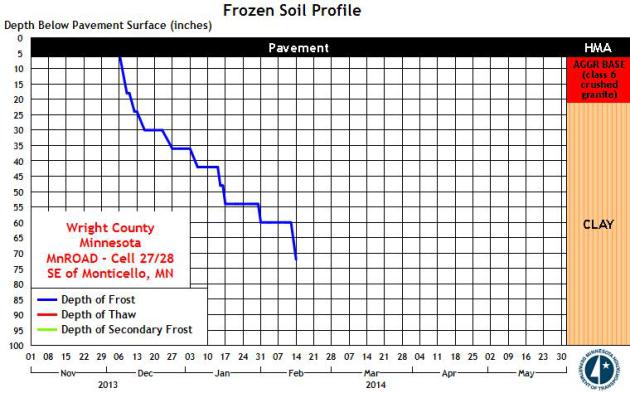
Frost And Thaw Depths.
How bad will spring flooding be? It depends on many factors, including
the rate of warming, and whether (heavy) rain accompanies the inevitable
warm fronts to come. That, and the depth of the ground frost. Until we
lose frost from the ground rain and melting snow will be unable to soak
into topsoil. With this year's persistent chill the ground frost is
unusually deep, over 70" deep in Otsego (Wright County). Thanks to MnDOT for providing this link to check out frost depth close to home.

Roses In Bloom Across Germany.
A relative near Cologne, Germany sent me this photo of her prize roses,
now in full bloom. In mid-February. Yes, highly unusual. Eva Fels-Huber
writes:
Highs
have been in the 50s in recent weeks. My father, who translated the
e-mail for me, points out that roses bloom after crocus, tulips, and
daffodils. The Symphony of the Seasons is seriously messed up.
Springlike weather in Sochi for the (alleged) Winter Olympics, while the
Polar Vortex stalls over the northern USA. Biblical flooding in Britain
while California wilts during historic drought. The Winter of All or nothing.

* Computer guidance showing a growing potential for blizzard or near-blizzard conditions for Boston and Cape Cod late Saturday and Saturday night, with sustained winds of 30-40 mph producing white-out conditions.
* 6-10" of additional snow likely in the Boston area, over 1 foot for Cape Cod with significant blowing and drifting, peaking Saturday night.
* New York City may pick up about 2" of snow from this coastal storm Saturday; heavier amounts over Pennsylvania and upstate New York.
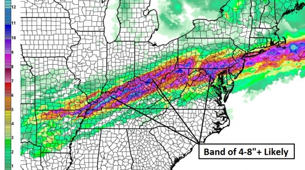
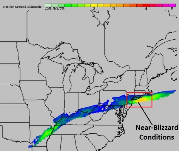
Summary: Although the brunt of the next coastal storm will remain just offshore, there's growing confidence in a forecast of hazardous to treacherous winter conditions from near Providence to Boston Saturday PM and nighttime hours. I expect delays and cancellations at Boston Logan, especially after 3 PM ET Saturday. Conditions improve during the day Sunday as snow tapers and winds begin to ease.
Paul Douglas - Senior Meteorologist - Alerts Broadcaster
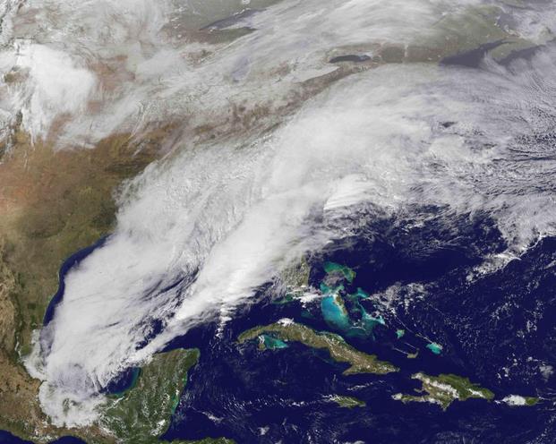
Roanoke, VA:
19"- biggest 24-hour snowfall in 18 years
Third-biggest snowfall recorded
Blacksburg, VA:
20.1"- 3rd-snowiest snowfall recorded
Philadelphia, PA:
4th 6"-plus
5th snowiest season on record already!
Central Park, NYC:
54" so far this season, now 9th snowiest season on record
Minneapolis averages 54" for the season, has 40.4" so far this year.
Baltimore:
Set single-day precip/liquid equivalent total with 1.77"
A Real Winter
- This winter has led to the most flight cancellations in 25 years
- More than 75,000 flights have been cancelled since Dec. 1 (about 5.5% of flights)
- Includes 14,000 flights cancelled this week alone
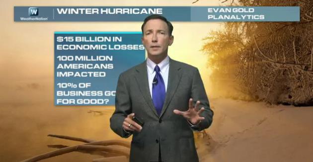
Winter-Cane.
Although this week's ice and snow storm didn't produce as much
structural damage as a hurricane, if you look at economic losses related
to the wintry smack damage will probably be equivalent to a moderate
hurricane hitting a populated coastal region of the USA; one weather
analyst at Planalytics estimates $15 billion in economic losses. That,
and the the fact that New York City has picked up considerably more snow
than the Twin Cities, Denver and Anchorage (!) is the subject of
today's Climate Matters: "WeatherNationTV
Chief Meteorologist looks at the details and impacts of the winter
storm that impacted everything from Texas to Maine. We've seen the
pictures of the damage, but what happened? 75,000 flights cancelled this
winter and find out which places are WAY above normal for snowfall."

Warm Weather Leaves You In The Mood To Buy.
No kidding. And we tend to attach a higher price/value to objects when
it's warm outside. Confirming what may just be good old fashioned common
sense, here's a clip from The Journal of Consumer Psychology at sciencedirect.com. What, you don't skim this from time to time? "A
series of five field and laboratory studies reveal a
temperature-premium effect: warm temperatures increase individuals'
valuation of products. We demonstrate the effect across a variety of
products using different approaches to measure or manipulate physical
warmth and different assessments of product valuation. The studies
suggest that exposure to physical warmth activates the concept of
emotional warmth, eliciting positive reactions and increasing product
valuation. Further supporting the causal role of emotional warmth, and
following prior research relating greater positive feelings to reduced
distance, we find that warm temperatures also reduce individuals'
perceived distance from the target products..."
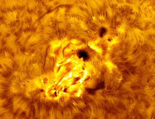
Auroras For Valentine's Day? More activity on the sun - no promises (there never are), but here's a clip from spaceweather.com: "Three
CMEs are heading for Earth. Individually they are minor clouds.
However, by striking Earths magnetic field in quick succession on Feb
14-15, they could cause significant geomagnetic activity around the
poles. High latitude skywatchers should be alert for auroras on
Valentines Day when NOAA forecasters estimate a 60% chance of
geomagnetic storms..."
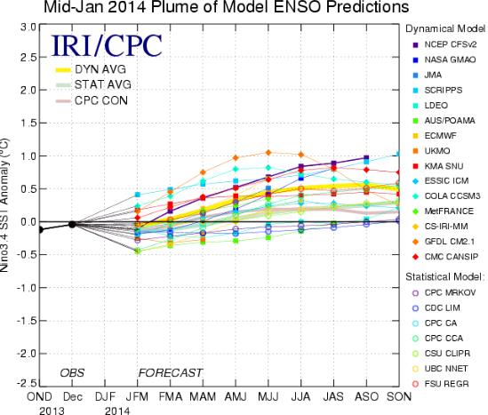
El Nino May Make 2104 The Hottest Year On Record. New Scientist has the article; here's the introduction: "Hold
onto your ice lollies. Long-term weather forecasts are suggesting 2014
might be the hottest year since records began. That's because climate
bad-boy El Niño seems to be getting ready to spew heat into the
atmosphere. An El Niño occurs when warm water buried below the surface
of the Pacific rises up and spreads along the equator towards America.
For nine months or more
it brings rain and flooding to areas around Peru and Ecuador, and
drought and fires to Indonesia and Australia. It is part of a cycle
called the El Niño-Southern Oscillation..."
* NOAA NCEP's latest ENSO discussion is here.
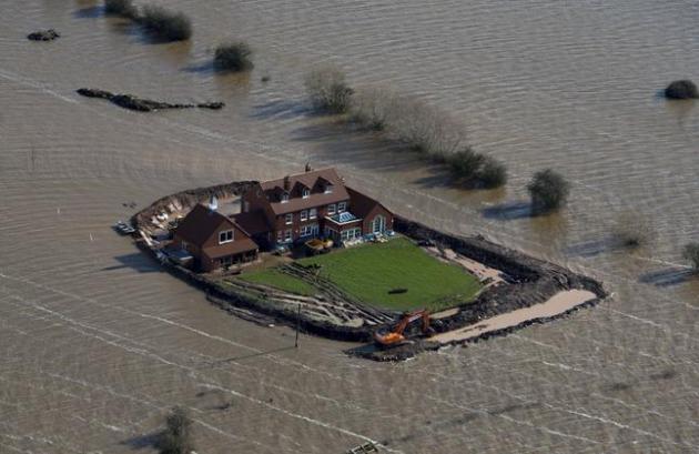
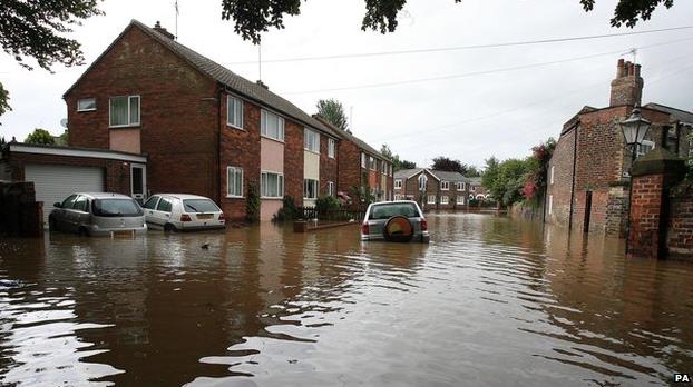
Flood Simple: The U.K. Flooding Crisis Explained. I thought The Guardian
did a very good job explaining why the wettest winter in 250 years
across much of Britain is creating so much chaos and devastation; here's
an excerpt: "Rainfall which in many areas has been twice the
average for January and February has left large parts of southern
England under water. What causes the unusual weather, why is the country
so ill-prepared, and what will be the political effect of 2014’s watery
winter?..."
Photo credit above: "Flood
waters inundate the area as one house stands alone near the flooded
village of Moorland in Somerset, southwest England, Thursday Feb. 13,
2014. The house is owned by Sam Notaro, who has built his own levee to
hold back the flood waters, as the local communities face further misery
in the coming days with heavy rain, wind and snow predicted to sweep
across Britain." (AP Photo/Steve Parsons, PA)
The Dust Bowl Returns.
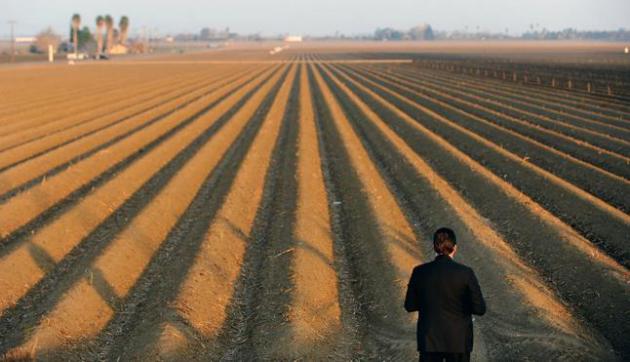
With California entering the third year of an historic drought, and
precious little rain or snow this winter season, the stage is set for a
year of extreme drought, water shortages and record wildfires out west.
Here's a clip from a story at The New York Times: "...Experts
offer dire warnings. The current drought has already eclipsed previous
water crises, like the one in 1977, which a meteorologist friend,
translating into language we understand as historians, likened to the
“Great Depression” of droughts. Most Californians depend on the Sierra
Nevada for their water supply, but the snowpack
there was just 15 percent of normal in early February. And the dry
conditions are likely to make the polluted air in the Central Valley —
which contributes to high rates of asthma and the spread of Valley Fever,
a potentially fatal airborne fungus — even worse. The current crisis
raises the obvious question: How long can we continue to grow a third of
the nation’s fruit and vegetables?.."
Photo credit above: "A
sercret service agent looks over a farm field as President Barack Obama
speaks to the media on California's drought situation Friday, Feb. 14,
2014 in Los Banos, Calif. Farmers in California's drought-stricken
Central Valley said the financial assistance President Barack Obama
delivered on his visit Friday does not get to the heart of California's
long-term water problems." (AP Photo/Los Angeles Times, Wally Skalij, Pool).
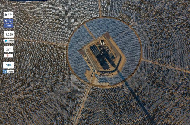
This Is What The World's Largest Solar Plant Looks Like When It's Catching Rays. The Verge has the story - here's an excerpt: "A
massive solar plant in the Mojave Desert officially began operation
today after years of construction, testing, and development. Co-owned by
NRG Energy, BrightSource Energy, and Google, the Ivanpah Solar Electric
Generating System is said to be ready to generate nearly 30 percent of
all solar thermal energy produced in the United States. The plant
consists of three 459-foot tall towers each with tens of thousands of
robotic, garage-door sized mirrors that angle sunlight toward a water
boiler sitting atop them..."
All images credit of BrightSource Energy.

From The Desk Of A Former FCC Commissioner.
Will the pending Comcast - Time Warner merger be a good thing for
consumers? The big get bigger, which seems to be the way of the world.
Here's an excerpt of an interesting take from a former FCC Commissioner
at Columbia Journalism Review: "...So
instead of making good things happen, I would be spending untold hours
listening to big media tell me how their latest merger proposal would
translate into enormous “efficiencies” and “economies of scale” to
produce more and better news. Meanwhile, everywhere I looked, I saw
newsrooms like yours being shuttered or drastically downsized, reporters
getting the axe, and investigative journalism hanging by the most
slender of threads. Instead of expanding news, the conglomerates cut the
muscle out of deep-dive reporting and disinvested in you..."
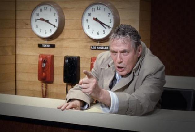
Still Mad As Hell. Remember Howard Beale in the movie "Network"? We're so far beyond that now. An Op-Ed from Maureen Dowd at The New York Times resonated with me; here's an excerpt: "...What
would Paddy rant about the viral, often venomous world of the Internet,
Twitter and cable news, where fake rage is all the rage all the time,
bleeding over into a Congress that chooses antagonism over
accomplishment, no over yes? What would he think of ominous corporate
“synergy” run amok, where “news” seamlessly blends into promotion, where
it’s frighteningly easy for corporate commercial interests to dictate
editorial content?..."
32 Famous People Rejected By Saturday Night Live. I found this nugget interesting, courtesy of Mental Floss. Here's a clip: "The
39-year history of Saturday Night Live is littered with thousands of
sketches, hundreds of guest hosts, and even more Not Ready for Prime
Time Player wannabes—some more memorable than others. In fact, the list
of now-famous folks who auditioned and were denied access to a permanent
spot in 30 Rock’s Studio 8H is long enough to fill multiple casts on
their own..." (Image above: NBC).
Here's a YouTube clip of the event. I had a blast participating last year - hope you can stop by and make an appearance, supporting a very good cause, the ICA Food Shelf: http://youtu.be/GqwGOB8A14E

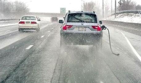
TODAY: Dusting or coating of light snow and flurries. Winds: SE 10-15. High: 20
SATURDAY NIGHT: Flurries taper, a few slick spots. Low: 8
SUNDAY: Partly sunny, not subzero. High: 24
SUNDAY NIGHT: More light snow arrives - roads may be slick for the Monday AM commute. Low: 20
MONDAY: A few inches of additional snow? Potentially plowable. High: 26
TUESDAY: Patchy clouds, turning milder. Wake-up: 24. High: 36
WEDNESDAY: Hints of March. Clouds increase. Wake-up: 21. High: 38
THURSDAY: More accumulating snow/ice. A few inches of slushy snow possible. Wake-up: 31. High: 34
FRIDAY: Colder with intervals of sun, better travel day. Wake-up: 15. High: 26
Climate Stories...
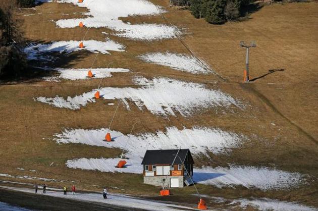
Photo credit above: "Slopes were closed last month at Fichtelberg mountain in Oberwiesenthal, Germany." Jan Woitas/European Pressphoto Agency.
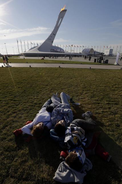
Photo credit above: "Visitors to the Olympic Park enjoy the warm weather at the 2014 Winter Olympics, Friday, Feb. 14, 2014, in Sochi, Russia." (AP Photo/David J. Phillip).
No comments:
Post a Comment