By Todd Nelson
"Absence makes the heart grow fonder" - Thomas Haynes Bayly; 1844.
At this point in the winter season, it's hard to imaging what 70F would feel like. The more and more I think about it, the more and more I yearn for it. Has anybody invented a winter blinder that you can install in January or February? Let me know... In the meantime, take those well timed vacations to get you through the 'darker' days of winter. We deserve it, right? Tell that to my back account!
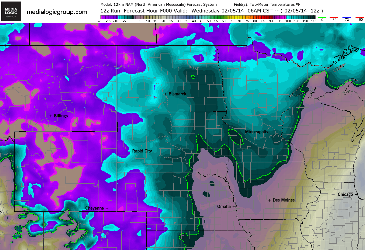
Our eye-stinging, bright white landscape isn't going anywhere anytime soon. As of midday Wednesday, the MSP Airport reported 14" of snow on the ground with nearly 2.3" of water locked in that snow pack. That stat will come in handy in several more weeks during the spring flooding season.
I hate to sound like such a Debbie Downer. This cold and snowy weather is great news for folks that make a living during this time of the year. Hey, snowmobile and ice fishing sales are up! I hear the bite on certain lakes has been quite good this year too. We call ourselves "hardy" in Minnesota, why not live it up? I guess it's just a little hard to get used to an old fashioned winter. Maybe it's just me - wimp.
______________________________________________________________________
WEDNESDAY NIGHT: A few flurries possible. Bitter wind chills return by morning. Low: -8. Feels Like: -20F.
THURSDAY: Bitter sun. Brisk wind chill. High: 4. Feels Like: -20F early. Winds: West 10.
THURSDAY NIGHT: Clear, cold and quiet. Low: -8. Feels Like: -15F
FRIDAY: Stubborn cold continues. High: 12
SATURDAY: Light snow, mainly southern MN. Wake-up: 0. High: 13
SUNDAY: Clearing, turning colder. Wake-up: -8. High: 3
MONDAY:Old Man Winter receives threats. Wake-up: -10. High: 3
TUESDAY: What else, but more cold sun. Wake-up: -5. High: 10.
WEDNESDAY: More clouds, light snow late? Wake-up: 2. High: 16.
_____________________________________________________________________
MSP Temp Trend
For those of you looking for any light at the end of the tunnel, unfortunately, our colder than normal weather will likely stick around through the middle of February. Here's our temperature trend into early next week.
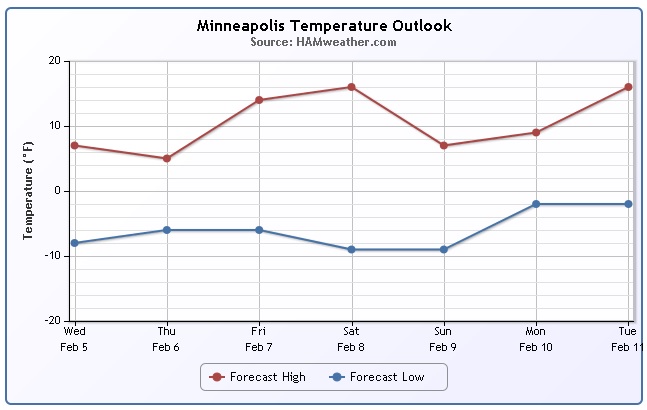
Stubborn Cold Continues
I've definitely seen enough pink and purple on weather maps this winter season... I wish it would ease up some. Here's the chilly outlook through Saturday.
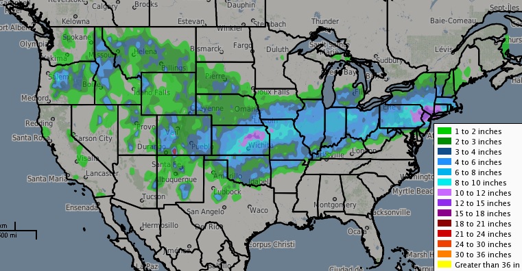
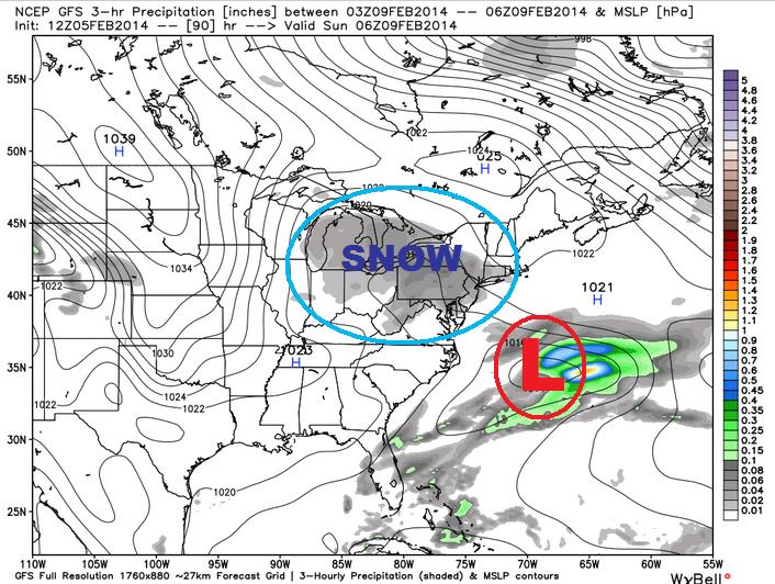
Cold Pushes Snow South
Thanks to the recent cold air invasion across the Upper Mississppi Valley, we've seen the storm track settle south just a bit. This unfortunately has been bringing round after round of wintry weather to the middle and eastern part of the country. We've actually seen 3 different winter storm since late last week and 2 seperate systems since Super Bowl Sunday. Here's the snowfall analysis over the past 72 hours. The last one on Tuesday/Wednesday was a doozy. There were several reports of 6" to 12" from the Central Plains to the Northeast. There were even a few reports exceeding a foot!
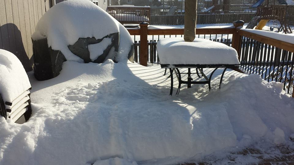
No Grilling Zone
Thanks to my good friend Matt Dux for this image near Kansas City, MO after nearly 10" fell! It laments that it's going to be a little hard to get to the grill.
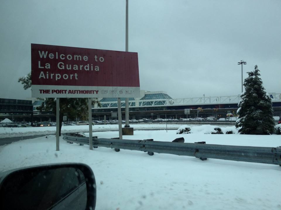
Snowy in New York
Here was the scene from midday Wednesday as my good friend and colleague Addison Green drove up to the La Guardia Airport. His flight was originally delayed several hours due to the storm on Wednesday and eventually canceled. Addison was one of several thousand people that had traveling issues at some of the major hubs on Tuesday & Wednesday.
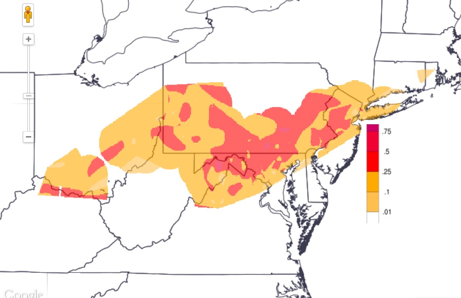
Ice Accumulations
Thanks to the National Weather Service Eastern Region for the image below, which suggests the ice accumulations from our latest storms system for folks in the Northeast. According to the map below, there were several locations that had 0.25" to nearly 0.50" of ice! One report out of Marion, KY boasted 0.75"! Keep in mind that just 0.50" of ice can add up to 500lbs. of extra weight to a span of power lines (pole to pole). No surprise power outages are a big concern during ice storms!
Significant Ice in Louisville, KY
Thanks to Drew Cooks via CN2 for this image out of Louisville, KY.

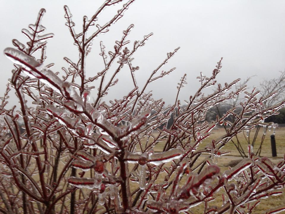
Brambleton, MD
Here's another icy shot from my good friend Amy Bettwy out of Brambleton, MD
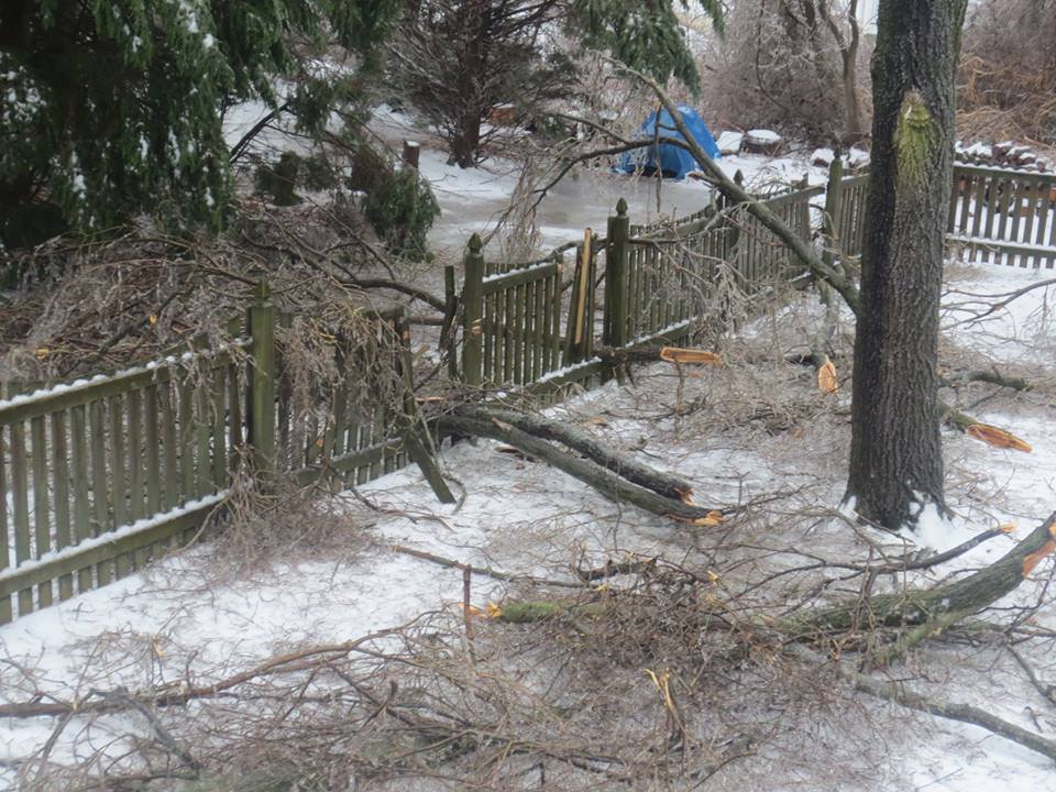
Ice Storm Damage
Thanks to Kelly Heil out of Forest Hill, MD for this picture, which looks unpleasant. Unfortunately, this was a common scene for the recent ice storm on the southern edge of the heavy snow swath. At one point on Wednesday, there were more than 1 million customers without power across the nation from the snow and ice.
Here were some of the reports from AM Wednesday:
Pennsylvania: 701,215
Maryland: 135,567
Arkansas: 49,506
Kentucky: 43,889
New Jersey: 28,098
West Virginia: 23,633
Tennessee: 11,005
Ohio: 12,798
New York: 4,540
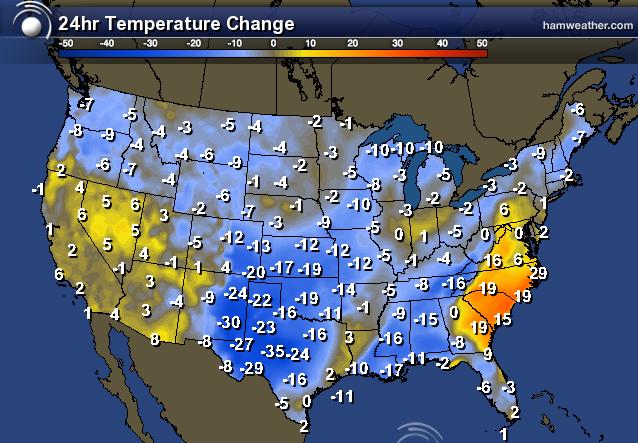
Colder Behind the Storm
Take a look at the 24 hour temperature change from yesterday afternoon across the country. Note the significant drops across the southern part of the country.
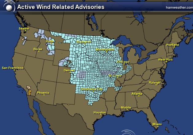
Widespread Wind Chill Concerns
WOW! Take a look at how widespread the wind chill concerns will be through midday Thursday. Withing these areas, we could see feels like temps from -10F to -35F!
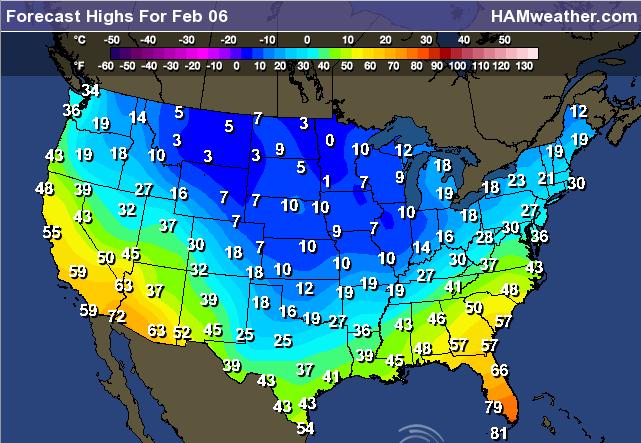
Cold Thursday Ahead
Brrr... Here's the chilly outlook for the nation on Thursday.
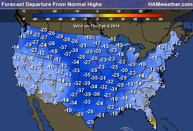
Highs From Normal Thursday
Much of the nation will below average with the exception of the far southern tip of Florida. However, a large chunk of the nation with be significantly below average.
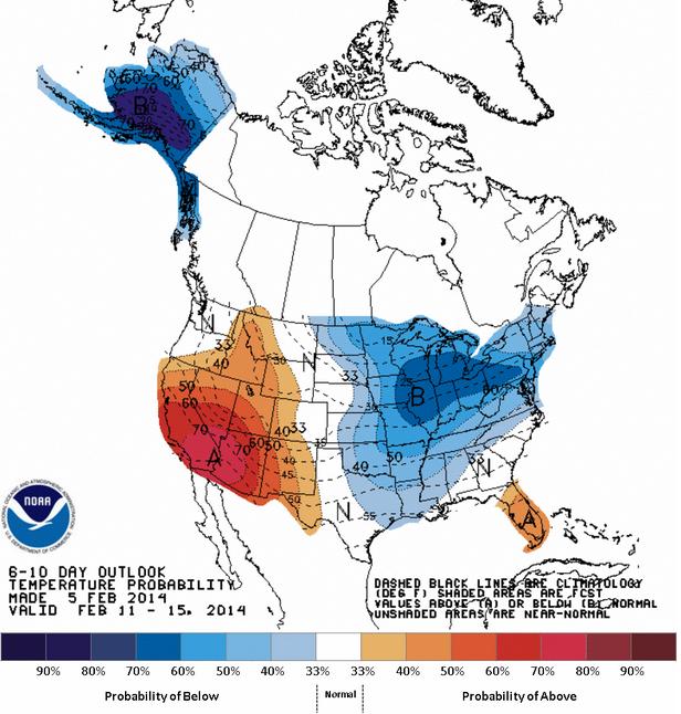
6 to 10 Day Temperature Outlook
According to NOAA's Climate Prediction Center, there's still a good chance that the eastern half of the nation will see below average temperatures, while the southwestern part of the country could see warming temperatures. Also note Alaska could see a temperature drop by mid February.
Goodbye Storm - Hello Next Storm
As we say goodbye to one storm, our attention shift once again to the west. It appears the western part of the country will stay quite active through the upcoming weekend.
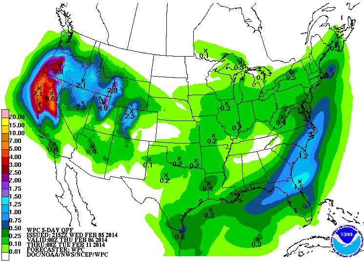
Much Needed Precipitation
Well this is good timing! Just after parts of California were added to the highest drought classification for the state in recorded history, well timed moisture has moved in. Even though we're seeing moisture, we are still well behind normal and need several more of these systems before we can even think about peering out of the woods. According to NOAA's HPC 5 day precipitation forecast, some areas across northern California could see 5" to 7" of precipitation by Monday evening.
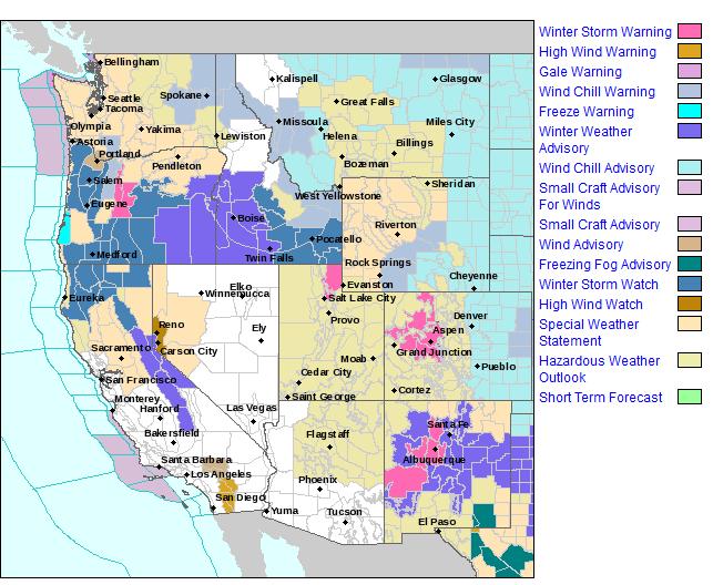
Western Warnings
The National Weather Service has issued several winter weather headlines for the incoming storm(s). Here are some of the latest headlines.
THE NATIONAL WEATHER SERVICE IN SACRAMENTO HAS ISSUED A WINTER WEATHER ADVISORY ABOVE 4000 FEET FOR SNOW... WHICH IS IN EFFECT FROM 4 AM TO 10 PM PST THURSDAY.
* IMPACTS: EXPECT PERIODS OF HAZARDOUS TRAVEL, CHAIN REQUIREMENTS AND TRAVEL DELAYS OVER THE NORTHERN SIERRA PASSES.
* CONFIDENCE: MODERATE.
* TIMING: MODERATE SNOW FROM EARLY THURSDAY THROUGH THURSDAY EVENING. HEAVY SNOW POSSIBLE FRIDAY AFTERNOON THROUGH SATURDAY. SNOW LEVELS WILL RISE TO ABOVE 6000 FEET THROUGH THE DAY SATURDAY.
* LOCATIONS INCLUDE: BLUE CANYON...DONNER PASS...ECHO SUMMIT... CARSON PASS.
* SNOW ACCUMULATIONS: 4 TO 8 INCHES OF SNOW POSSIBLE ABOVE 4000 FEET THURSDAY. 1 TO 2 INCHES OF SNOW POSSIBLE DOWN TO 3000 FEET THURSDAY. 1 TO 2 FEET OF SNOW POSSIBLE ALONG THE SIERRA CREST FRIDAY AFTERNOON THROUGH SATURDAY.
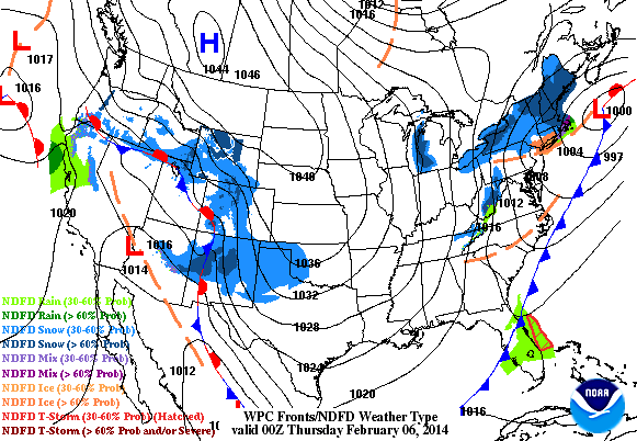
What About That Weekend Storm in the Northeast?
It's still something to watch as weather models have been fluctuating a bit, but we may be seeing a slight shift east in the storm track, which would mean that the storm would be as intense... stay tuned!
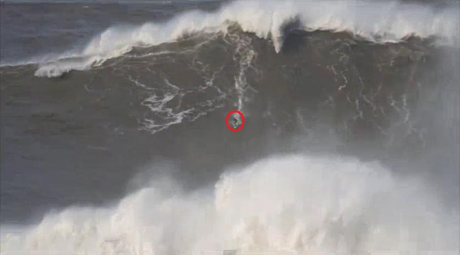
Surfer Tackles World Record Wave?
This is crazy! It's hard to grasp how BIG this wave REALLY is, but estimates have this thing around 80ft. and could certainly be worthy of a world record!
"Andrew Cotton, a 34-year-old surfer from England, took on one of the biggest waves of all time on Sunday despite harsh weather conditions in Portugal. When the crest of the 80-foot wave caught up with him, he tumbled, disappearing beneath the water's surface for a brief moment.
Cotton told the BBC his fall was "pretty bad" and described the windy conditions as "bordering on unsurfable." He was wearing an inflatable vest which shot him up to the surface of the water."
See the full story & VIDEO from mashable.com HERE:
Thanks for checking in and have a great rest of your week!
Twitter: @TNelsonWNTV
No comments:
Post a Comment