10 F. high in the Twin Cities Monday.
35 F. average high on March 3.
32 F. high on March 3, 2013.
19" snow on the ground at KMSP.
11 hours, 17 minutes. Amount of daylight in the Twin Cities today.
8 hours, 46 minutes. Amount of daylight on the Winter Solstice, on December 21, 2013.
Still Standing
Have
we reached an epic new low for winters in Minnesota? Maybe. 50 subzero
lows IS impressive, but Kent Smith in Eden Prairie and Pete Boulay at
the Minnesota Climate Office both confirm no record lows this winter at
MSP, which I found a bit odd. A spree of subzero lows but nothing
record-breaking. 9th coldest meteorological winter on record at KMSP,
and based on heating degree days we've spent 12.3 percent more than
average heating our homes this winter. Whatever average is.
Two
meteorological trends I've noticed in recent years: a tendency for
weather to stall, to get "stuck". And more volatility, more extremes,
more weather whiplash.
Think about it. Two years ago we saw 60F
the first week of March; 80F by mid-March. Flowers were in bloom &
sail boats were in the water by late March, on our way to a 7 month
boating season! This winter we feel blessed just to see freezing.
"Every
winter seems like a new low" my oldest son complained. Here's a guy
that lived for snow days and shrugged at cold fronts growing up. Now
he's thoroughly disgusted. I sense he's not alone. Last winter it snowed
in early May, creating a chorus of groans. The groans have turned into
gasps.
No epic, March Tournament storms are brewing anytime soon;
an inch or two from a fast-moving clipper tonight - a better chance of a
few inches of slush next Tuesday as a more significant storm spins up
over the Midwest - the brunt of snow, ice and rain may stay south and
east of Minnesota, but it could be a close call.
Remarkably no
more subzero lows are in sight. We brush 32F Thursday; 40F is possible
next week. I'm nervous saying this out loud, but I sense we're finally
turning the corner... on a winter to remember.
* photo above courtesy of
duckduckgrayduck.com.
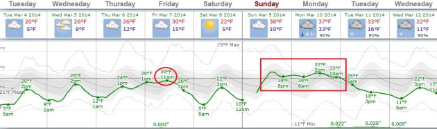
Another Cruel Meteorological Mirage?
I know, we've been burned too many times by long-range models that
dangle the possibility of 30s, only to get closer to the blessed event
and have them vanish into thin, Canadian air. The temperature trend is
upward, a hint of low 30s by Friday, then cooling off Saturday before a
more significant whiff of Pacific air arrives early next week. A thaw
seems likely Sunday and Monday before cooling down. Look carefully at
the ECMWF (European) guidance above. Notice anything unusual? No subzero
lows predicted. That's progress, in a ghastly, pathetic sort of way.
Graph: Weatherspark.
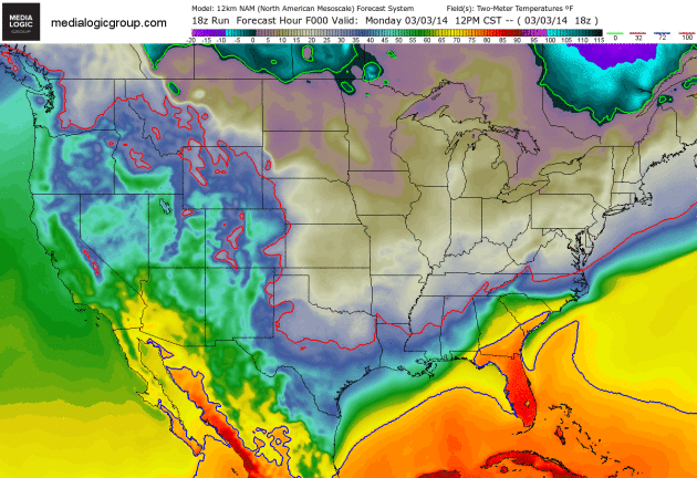
A Sluggish Thaw.
With all the snow on the ground I guess we should be hoping for a
slow-motion thaw, and that's exactly what we'll get later this week. The
solid red line marks the 32F isotherm, pushing north Wednesday and
Thursday. All that snow and ice in your yard will melt. Give it a month
or two. 2 meter NAM temperature forecast courtesy of NAM and Ham
Weather.
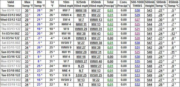
Extended GFS Numbers.
Yes, I'm skeptical of (all) long range models now, after the persistent
polar rut we've been in since December. But the GFS is fairly
consistent, run to run, showing mostly 30s the third week of March.
We'll see, but it's probably still too early to celebrate.
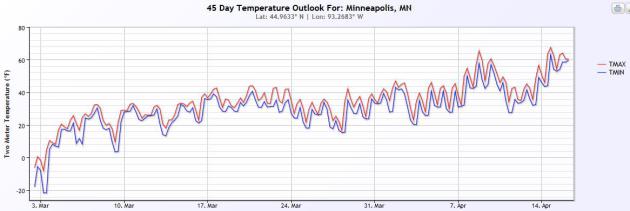
Upward And Onward.
At least if you believe NOAA's 45-day trends, the CFS (Climate Forecast
System) model, which I lovingly describe as the "Wish-Cast". It shows
highs topping 40F by the third week of March, some 50s to near 60F the
second week of April. One prediction with rare 100% accuracy: none of us
will EVER take spring for granted again. Graphic: NOAA and Ham Weather.
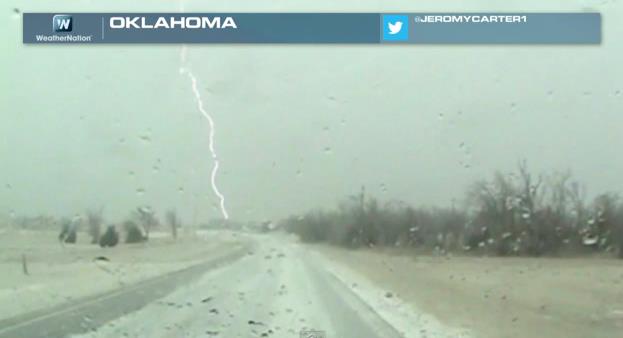
Serious Weather Whiplash.
Cloud to ground lightning during heavy snow and sleet - in Oklahoma?
The maps have been looking like early February, not early March, with
cold and snow pushing as far south as Texas. From drought in the west to
a parade of storms east of the Rockies, record warmth in Las Vegas to
73" snow in Chicago (43" above average, to date) the extremes have been
even more extreme. That's the topic of today's edition of
Climate Matters: "
WeatherNationTV
Chief Meteorologist Paul Douglas goes over the two very different
winters that the United States saw this year. While the Eastern half of
the US saw well above average snow and bone chilling cold, folks in Las
Vegas enjoyed the warmest winter on record! Talk about weather whiplash!"
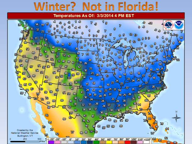
What March?
Here's a good excuse to consider Florida - although I hate it when they
get smug and start to gloat. Wait until summer-sauna and hurricane
season, eh? Map above: NOAA.
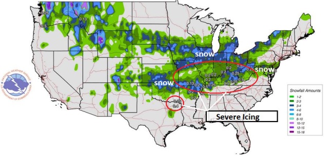
Preliminary Snow/Ice Totals. The map above is courtesy of
NOAA,
showing snow and ice totals from 7 AM March 1 to 7 AM March 3. Much of
the Ohio and Middle Mississippi River Valley picked up .25 to .50" of
glaze ice.
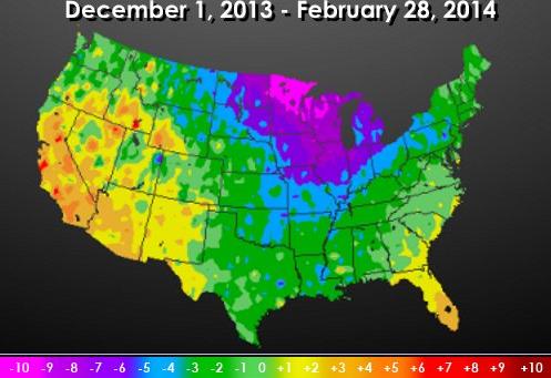
National Temperature Departures During Meteorological Winter.
All those locations in green, blue and purple experienced colder than
average temperatures from December thru February (no kidding). Only the
far southeastern USA and much of the southwest was warmer than average.
Map: University of Nebraska, HPRCC and Larry Cosgrove's WEATHERamerica
newsletter.
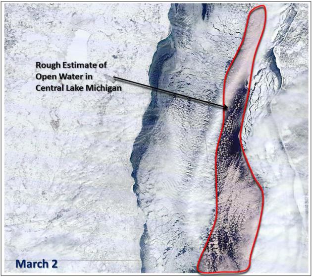
Lake Michigan Is 90% Ice-Covered. That compares with a maximum ice cover of 20% last winter. Map above and more details from the
Milwaukee office of the National Weather Service.
 Ask Paul
. Weather-related questions, comments (and threats):
"
How many hours has Mpls been above freezing since November 1, 2103? Thank you."
Lyman Dale
I
asked local weather and climate guru Pete Boulay at the Minnesota
Climatology Working Group to tally up the numbers. Here is an excerpt of
his reply:
"
The more impressive totals are number of hours that we had above 32 degrees for meteorological winter.
December: The Twin Cities International Airport had 64 hours of above freezing temperatures 33 or warmer
January:
The Twin Cities International Airport had 34 hours of above freezing
temperatures 33 or warmer in January and one hour of 40 degrees and that
one hour was glorious.
February: The Twin Cities International Airport had was 32 hours for 33 degrees and above."
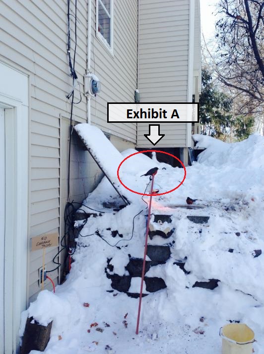
Reluctant Robin Retraction.
In Monday's weather column I mentioned that "I can't promise robins or
daffodils anytime soon". Howard Richards begs to differ:
"
I had 8 of them vying for a spot around my heated birdbath in Mound on Sunday. I don’t think they ever left last fall!"
Best Regards, Howard Richards
Plymouth, Minnesota
No Green In Green Bay. In fact, according to
NOAA, it's the third longest streak with a foot of snow or more on the ground at KGRB.
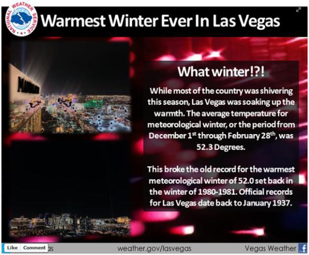
Warmest Meteorological Winter on Record in Las Vegas. Welcome to the Winter of All or Nothing, at least in terms of warmth. Details from
NOAA.
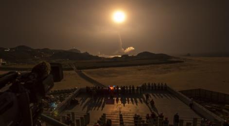
GPM Weather Observatory Successfully Launched.
Gizmag has more details on a new weather and climate platform just launched into low orbit; here's an excerpt: "...
A
joint mission between NASA and the Japan Aerospace Exploration Agency
(JAXA), the Global Precipitation Measurement (GPM) Core Observatory is a
4-ton spacecraft (and the largest spacecraft ever built at NASA's
Goddard Space Flight Center) that will join a constellation of existing
and future spacecraft to provide detailed information on the Earth's
weather and climate cycles by mapping global precipitation every three
hours..."
Photo credit above: "
The GPM Core Observatory is launched aboard a Japanese H-IIA rocket from the Tanegashima Space Center last week." (Photo: NASA/Bill Ingalls).
Tame Hurricanes With Offshore Wind Farms.
You'd need a lot of turbines to blunt the raw power of a major
hurricane, but this idea may not be as far-fetched as it sounds. Here's
an excerpt of a Stanford University study from
futurity.org: "
Computer
simulations show that offshore wind farms with thousands of turbines
could have sapped the power of three real-life hurricanes, significantly
decreasing their winds and accompanying storm surge, and possibly
preventing billions of dollars in damages. For the past 24 years, Mark
Z. Jacobson, professor of civil and environmental engineering at
Stanford University, has been developing a complex computer model to
study air pollution, energy, weather, and climate. A recent application
of the model has been to simulate the development of hurricanes. Another
has been to determine how much energy wind turbines can extract from
global wind currents..."
Photo credit above: "
Wind
turbines could potentially disrupt a hurricane enough to reduce peak
wind speeds by up to 92 mph and decrease storm surge by up to 79 percent." (Credit:
Department of Energy and Climate Change/Flickr)
Why Apple Could Win Big With Tesla's Giant New Battery Factory. Wired has the article; here's an excerpt: "...
This week, years after that first sighting, Tesla announced plans for what it calls the “Gigafactory,”
a 10-million-square-foot plant for making car batteries. The company
hopes that the sheer scale of the operation, combined with the
inventiveness of its engineers, will bring battery prices down far
enough to finally bring its electric cars into the mainstream. But it’s
not just the prospect of a gasoline-free future that has sparked such
excitement about the Gigafactory. The same basic lithium-ion tech that
fuels Tesla’s cars also runs most of today’s other mobile gadgets, large
and small. If Tesla really produces batteries at the scale it’s
promising, cars could become just one part of what the company does. One
day, Tesla could be a company that powers just about everything, from
the phone in your pocket to the electrical grid itself..."
Energy Sector's Newest Power Player: Elon Musk. Here's an excerpt of a story at
LinkedIn that caught my eye: "
Elon
Musk has established a well-deserved reputation for designing and
building things that take off quickly — rockets, electric cars … and
stock prices. But his biggest impact won’t necessarily be in speeding up
how we get from here to there. It may be in transforming a much
slower-moving industry: electric utilities..."
It Costs Five Times What It Did In 1970 To Spend A Day At Disney World. Save up your money if you're heading to Orlando to hang out with Goofy; here's a clip from a story at
Quartz: "...
Hanging out with Mickey Mouse is getting more expensive. Disney World hiked the price of a one-day ticket to the Magic Kingdom to $99 earlier this week. But it’s hardly the first time. The same thing happened last year. And the year before that. In fact, the price of a one-day ticket has been rising pretty steadily for decades, even after adjusting for inflation..."
TODAY: Clouds much of the day, warming up a little more. Winds: E 5-10. High: near 20
TUESDAY NIGHT: Light snow and flurries, an inch or two possible (more south of MSP). Low: 9
WEDNESDAY: Snow tapers early, partial PM clearing. High: 26
THURSDAY: Breezy, turning milder. More smiles. Wake-up: 14. High: 32
FRIDAY: Mild start, then cooling off a bit. Wake-up: 23. High: near 30
SATURDAY: Blue sky and cooler, good travel weather. Wake-up: 6. High: 22
SUNDAY: Some sun, finally feels like March! Wake-up: 13. High: 37
MONDAY: Sunny start, wet snow late PM? Wake-up: 30. High: 42
* a period of accumulating snow is possible next Monday and Tuesday. Too early for details.
Climate Stories....
 Don't Ignore Climate Change Realities.
 Here's an excerpt of an Op-Ed that appeared in
The Kansas City Star: "...
Using
information from around the globe, the National Oceanic and Atmospheric
Administration lays out compelling climate change evidence from the
last century:
-Global surface temperatures are rising.
-The index ranking extreme weather events in the United States is at its highest level in 100 years. (Think polar vortex.)
-Sea levels are rising; oceans are getting warmer.
-Glacier volume is shrinking dramatically..."
Scientists Discover New "Giant Virus" From 30,000 Year-Old Permafrost. Don't sweat the snow flurries ok? Here's the intro to a story at
Mashable: "
If
this sounds like it's coming straight from an episode of X-Files,
that's because it is. Well, almost. Scientists studying microorganisms
buried in Siberian permafrost, a layer of permanently frozen soil that
rings the Arctic, found and revived a new type of giant virus that had
been locked away for more than 30,000 years. The virus — pithovirus
sibericum, a new type of giant DNA virus characterized by its large size
and abundance of genes — is not hazardous to human or animal health..."
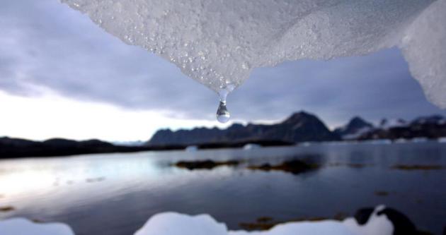
Photo credit above: "
An iceberg melts in Kulusuk, Greenland near the arctic circle Tuesday Aug, 16, 2005." Image: John McConnico/Associated Press.


Software Development Choose the Best Software Development Company in Delhi is also made best designing and CMS web application.
ReplyDeletehttp://www.razorse.com
ReplyDeleteThanks for sharing informative information
Thanks
Cpa offers