By Todd Nelson
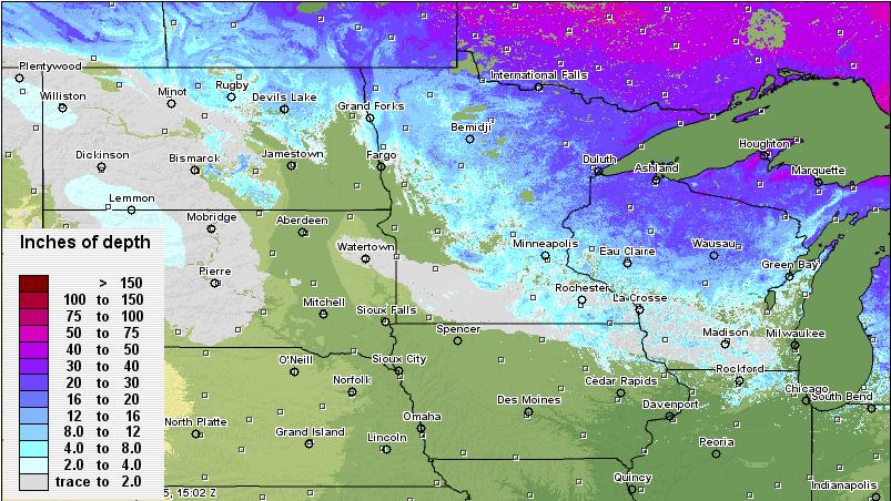
I had to rub my eyes a couple of times. I couldn't believe that I could actually see parts of my yard this weekend! In one week, we lost nearly 10" of snow cover officially at the Minneapolis/St. Paul International Airport. Last Sunday, the snow depth was 15" and as of Saturday, we had 5". The snow cover took a big hit this last week as we had high temps in the 50s twice; that's the first time we've had a high in the 50s since before Thanksgiving! Interestingly, we've had at least 10" of snow on the ground now since January 15th; the peak was 24" on February 21st!
I'd like to say that our snow cover will continue to dwindle heading through the end of March, but I can't. A storm system looks to be brewing for early next week. Early indications suggest that there will be accumulating snow for parts of Minnesota on Tuesday. Warm air on the southeast side of the storm will keep snow amounts lower, but the track is still questionable at this point. Just note that Tuesday and early Wednesday's travel could be less than ideal.
In the meantime, a Leprechaun warning has been issued for tomorrow. Keep your eyes peeled for any "small, mischievous sprites."
________________________________________________
SATURDAY NIGHT: Gradual clearing and colder. Low: 4. Winds: NE 5-15mph
SUNDAY: Cold start with sunshine. Clouds thicken late with a light wintry mix developing late across northern MN. High: 24. Winds: Becoming South 5-10.
SUNDAY NIGHT: Mostly cloudy with a light wintry mix across northern MN. Low: 17
MONDAY: Leprechaun warning. More clouds with a light wintry mix across northern MN. High: 36.
TUESDAY: Rain/snow early, then changing to all snow later. Best chance for accumulating snow in western and northern Minnesota. Wake-up: 27. High: 38
WEDNESDAY: Breezy and cooler with flurries. Wake-up: 26. High: 36
THURSDAY: Happy Spring! Partly sunny and warmer. Wake-up: 21. High: 40
FRIDAY: Clouds thicken, chance of rain/snow? Wake-up: 25. High: 42.
SATURDAY: AM flurry, gradual clearing. Wake-up: 26. High: 38.
_________________________________________________
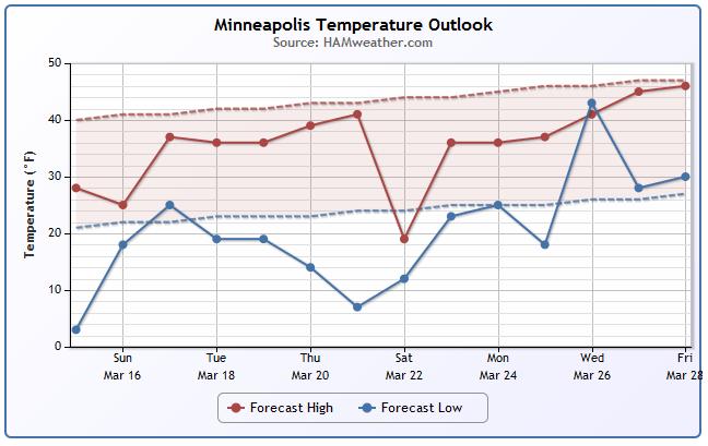
Minneapolis Temperature Trend
Here's a look at the temperature trend over the next 15 days for Minneapolis. The dashed lines represent the average highs and lows for this time of the year. Note that the highs appear to stay below average for a majority of the time, while the lows by next week will be well below average.
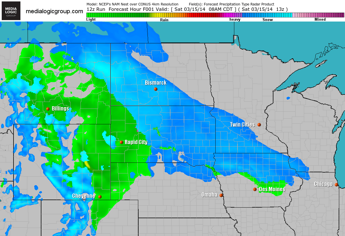
Future Radar
Here's the future radar into early next week. Note that by Monday, a quick burst of snow looks to drift through the northern part of the state.
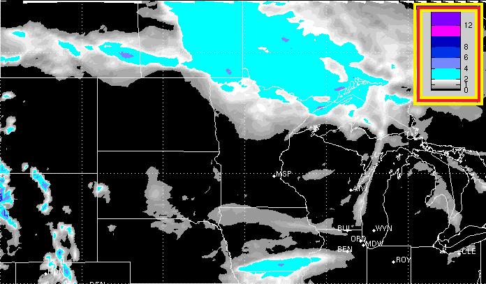
Snow Potential
The snow potential through PM Monday, shows the best accumulating snow chances across far northern Minnesota.
I Can See My Yard... Kind of
We've lost quite a bit of snow over the last 7 days. Last Sunday, the official snow depth at the Minneapolis/St. Paul International Airport was 15". Thanks to a rather mild stretch of weather over the past week, that number dropped to 5" as of Saturday!
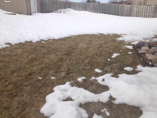
Snow Depth
Slowly, but surely the snowpack is shrinking. This is a look at the snow cover as of Saturday.
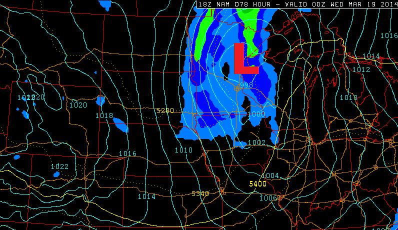
Growing Snow Potential
Weather maps continue to suggests a storm system moving through the Upper Midwest by early next week. The storm will wrap warmer air in on it's southeastern side, so snow amounts there should be lighter. Snow accumulations on the western and northern side could be decent... stay tuned! The image below shows the storm position by PM Tuesday.
Picture of the Day
One of my good friends snapped this picture in a recent flight into La Guardia this week. Nice picture!

Weather Ahead
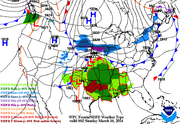
It's going to be pretty active through early next week. There are two storm systems that will push through the country. The first of which is sitting in the Lower Mississippi Valley and heading for the Eastern Seaboard through early next week. Heavy rain and strong thunderstorms will be found across the Gulf Coast States, while wintry precipitation will be found from the Middle Mississippi Valley to the Mid-Atlantic Region.
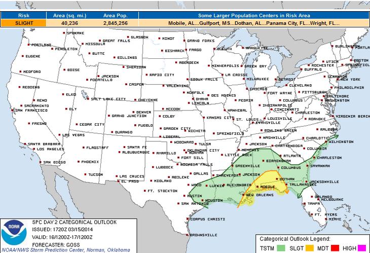
Sunday Severe Threat
The severe threat for Sunday doesn't look exceptionally significant, but there is a chance that some of the storms could be strong to severe.
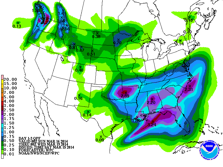
Precipitation Outlook
Here's NOAA's HPC 3 day precipitation outlook through PM Tuesday. Note the two blobs of heavier moisture; one in the Southeastern part of the country, while the second is located in the Upper Midwest. The southern severe threat looks be fairly weak across the Gulf Coast states with storm system number one, but the wintry precipitation on the northern flank this system look to be pretty substantial.
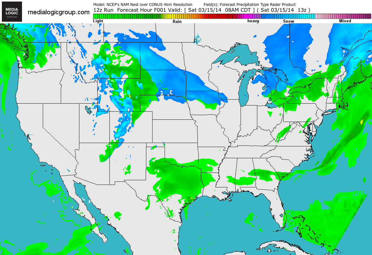
National Radar Forecast
Here's a higher resolution look at the southern storm as it intensifies over the Gulf Coast States. Note the heavier snowfall potential on the northern flank of the storm.
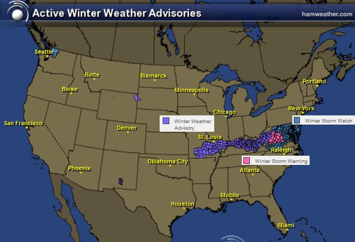
Wintry Weather Ahead
The National Weather Service has issued several winter weather headlines from the Middle Mississippi Valley to the Mid-Atlantic region. Snowfall amount could potentially be as much as 6" to 12" along and just east of the Appalachians.
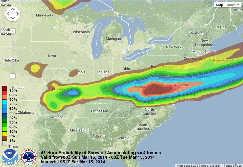
Probability of 4" of Snow
According to NOAA's WPC, the probability of at least 4" of snow or more is quite high from the Appalachians to the Eastern Seaboard.
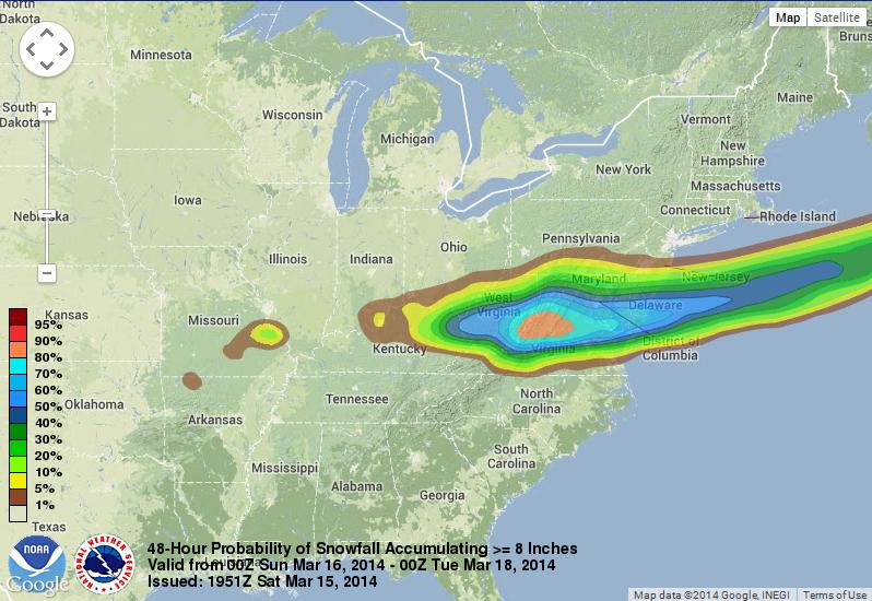
Probability of 8" of Snow
Even the probability of at least 8" of snow or more is quite high near the Appalachians.
Thanks for checking in and have a great rest of your weekend! Don't forget to check me out on Twitter @TNelsonWNTV

No comments:
Post a Comment