46 F. high in the Twin Cities Wednesday.
65 F. average high on April 30.
72 F. high on April 30, 2013.
.01" rain fell at MSP International Airport yesterday.
Minnesota Weather History on April 30, courtesy of the Twin Cities National Weather Service:
1966: Winter makes a last stab at Minnesota with a low of 5 at Cook. Hard freeze over the rest of the state.
1935:
An unusually late snow, sleet and ice storm over east central
Minnesota. The heaviest ice was between St. Paul and Forest Lake and
westward to Buffalo in Wright County, with snow and ice accumulations of
1 to 1.5 inches on wires. The Downtown Minneapolis weather bureau
recorded 3 inches of snow.
Big Swings
Welcome
to May, as in spring MAY finally arrive this month. We're due for a
major shift in the pattern and with a potentially major El Nino brewing
don't be surprised if we go from nagging chill to record warmth later in
2014.
We're all feeling pretty bruised & battered though
right about now. Factoring cold and snow it was the toughest winter in a
generation. April was the second wettest on record for the Twin Cities
with 6.25" of rain.
On a positive note: no drought, no severe
storms (it's been too chilly) and lawn-mowing season has been delayed by
a couple weeks.
That's about to change. The model guidance I'm
staring at shows a big northward bulge in the jet stream next week, with
a few 60s likely, even a shot at low 70s by midweek. I can't wait until
friends and family start griping about the heat. Next week should at
least partially restore your faith in a Minnesota spring.
The same
stalled storm rotates more bands of showers into town today, but skies
brighten Friday - upper 50s for Saturday & Sunday.
My son is a
Navy helicopter pilot. I remind him not to push the weather, in a
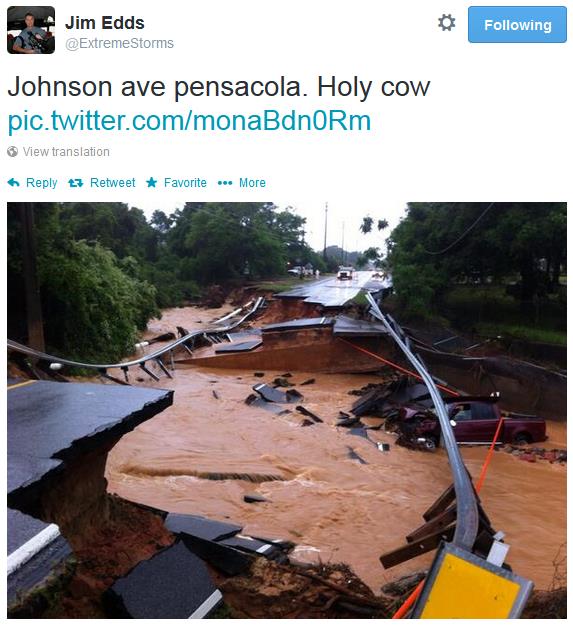
helicopter or a Camry for that matter. Tuesday night, driving through
historic rains in Pensacola, he did just that. 2 hurricane's worth of
rain fell in less than 8-10 hours. Somehow he was able to find his way
home amidst swamped police cruisers, flooded cars and washed out
highways. He was lucky.
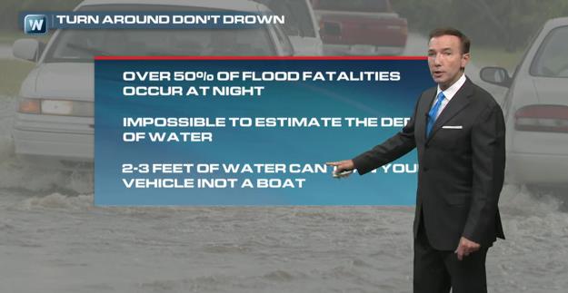
"Turn Around, Don't Drown."
That's a NOAA phrase, and it says it all. Most flash flood fatalities
take place at night, in vehicles trying to cross flooded streets. It's
impossible to estimate water depth, especially at night. Given the
option do the smart thing and stay put or turn around and find another,
safer way home. I had a close call with my youngest son Tuesday night
(stationed near Pensacola) when this massive flood, compared to
Hurricane Denny in 1997, engulfed a vast swath of the Gulf Coast from
Mobile to Pensacola and Destin. That's the subject of today's
Climate Matters.
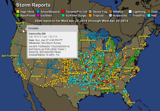
One Volatile Week.
When weather stalls bad things often result: more intense drought/heat
or extreme flooding. In the last week there were 3,606 severe weather
reports, nationwide. Red dots designate tornado touchdowns, yellow dots
signify high winds, green dots mark the location of flooding rain
events. There was even a small tornado in Washington state. Something
for everyone - expect tranquil weather. Interactive map:
HAMweather.
| Total Storm Reports: | 3606 |
| 0: | 1 |
| Wind: | 1533 |
| Rain: | 465 |
| Snow/Blizzard: | 462 |
| Ice: | 9 |
| Tornado: | 202 |
| Hail: | 879 |
| Fire: | 2 |
| Lightning: | 15 |
| Dust: | 34 |
| 14: | 1 |
| 16: | 2 |
| Tides: | 1 |
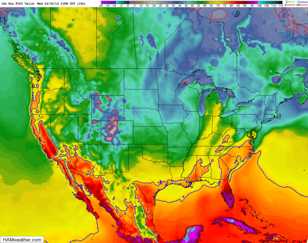
Sizzling Southwest - Warming Trend Central USA into Next Week.
NAM guidance shows 90 degree heat over central and southern California
and Arizona the next couple of days, a building ridge of high pressure
expanding into the southern and central Plains early next week. Much of
the northern USA chilled by the recent slow-motion storm will see slowly
moderating temperatures. Loop: NOAA and HAMweather.
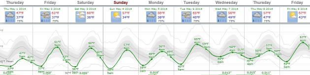
Looking More Like Spring.
Temperatures hold in the upper 40s to near 50F today, but if the sun
peeks out Friday 60F is a real possibility, a few days in the 60s next
week, even a chance of 70F by next Wednesday, depending on possible
convection. The arrival of warmer air may set off a few scattered
T-storms from Monday into Wednesday of next week. Graphic: Weatherspark.
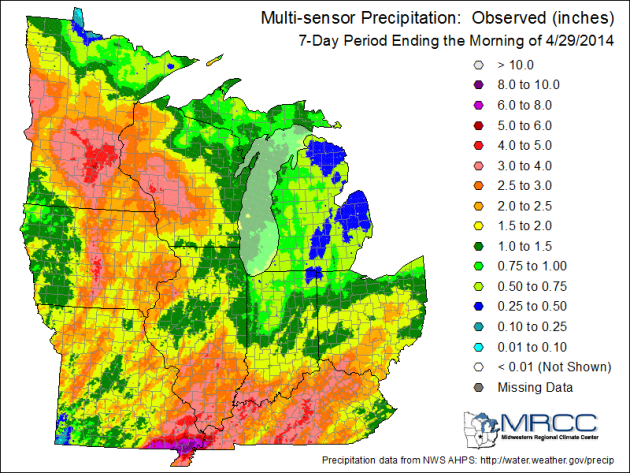
Monsoon Season. This map from the
Midwestern Regional Climate Center
shows how much rain has soaked the Midwest and Ohio Valley in just the
last week; in some cases 2 month's worth of rain. Over 8" estimated for
southeast Missouri, 4-5" for much of the Twin Cities metro area.
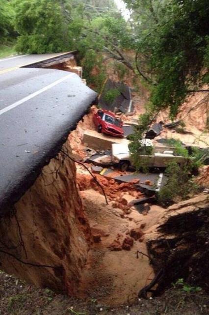
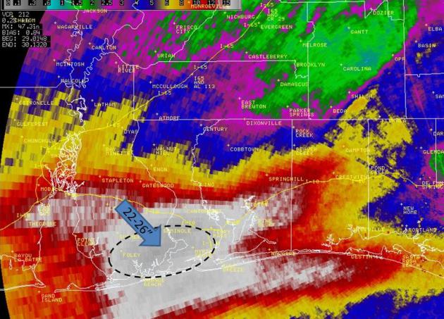
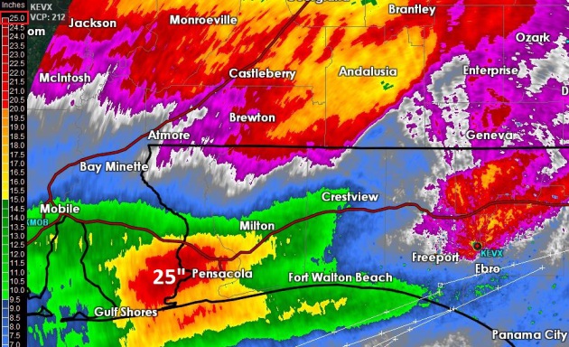
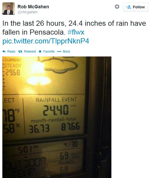
This Is What 2 Feet Of Rain In Less Than 8 Hours Can Do.
It was the equivalent of (two) slow-moving tropical storm's worth of
rain, as much as 24-26" of rain from training thunderstorms in the
Pensacola area Tuesday night. Details from
WeatherNation's Facebook page: "
Incredible
rainfall amounts are leading to extensive flooding damage in Pensacola,
FL. This picture from @oliverrhudy1 is of Scenic Highway falling off
the bluffs."
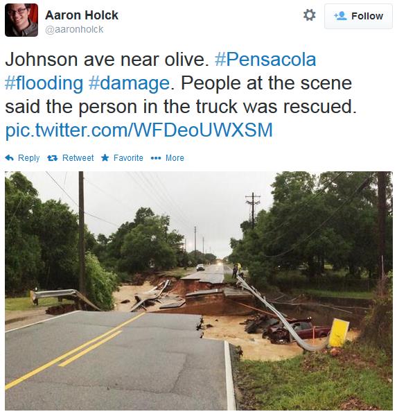
Historic Flash Flood Event. Some are comparing the flooding from Mobile into the Florida Panhandle with
Hurricane Danny in 1997.
Here's a good synopsis of the record flood event of Tuesday night,
which hit Mobile, Pensacola and surrounding communities so hard,
courtesy of the local
Mobile/Pensacola NWS: "
A
historic rainfall event developed ahead of a slow moving cold front on
Tuesday evening, 29 April 2014 over portions of coastal Alabama and the
western Florida Panhandle. The cold front was associated with a very
powerful low pressure system in the Plains. The widespread flooding
produced sinkholes (some very large and deep), cut roads in half and
necessitated human water rescues (one confirmed fatality). Parts of I-10
were closed. The Fish River at Silver Hill (Baldwin County Alabama)
peaked at a record high level of 23.18 feet (previous historical record
was 22.78 feet on 20 July 1997). Many folks throughout the area have
compared this event to the extreme flooding impacts caused by Hurricane
Danny (1997)..."
We're Going To Need A New Color Table.
A friend of mine spent a few minutes recalibrating the color table for
"storm rainfall" on GRLevel3 version 2.0, because the default table only
goes up to 5". No, you don't expect half a year's worth of rain in one
night. Amazing.
Officially yesterday, Pensacola (per NWS) had 11.13".
Pensacola averages: 4.35" for the month of April; 65.35" for the year.
Mobile: 11.24" at the airport made it the 3rd-rainiest day EVER there and the wettest since April 13th, 1955.
Mobile averages: 4.79" for April; 66.20" for the year.
* thanks to WeatherNation meteorologist Chris Bianchi for compiling these rainfall reports.
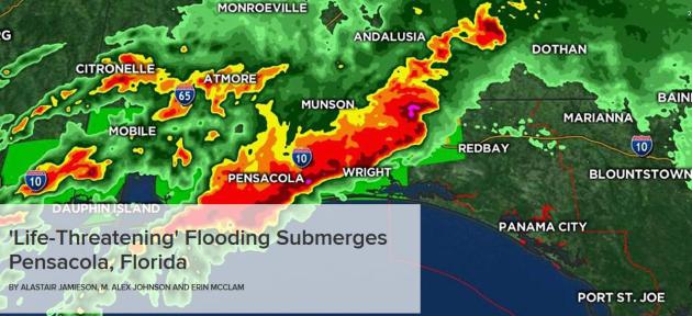
"Life-Threatening Flooding" Submerges Pensacola, Florida.
Some communities around Pensacola may have picked up 5-6 months worth
of rain in a few hours Tuesday night, creating a level of flooding and
mudslides usually only seen in the aftermath of severe hurricanes or
tropical storms.
NBC News reports: "
Forecasters
figured that the rain in Pensacola set a record, but they could not be
sure because a suspected lightning strike knocked out the National
Weather Service reporting station there. “We’ve had people whose homes
are flooding and they’ve had to climb up to the attic,” said Bill
Pearson, a spokesman for Escambia County, which includes Pensacola. He
said that authorities there described it as the worst flooding in 30
years..."
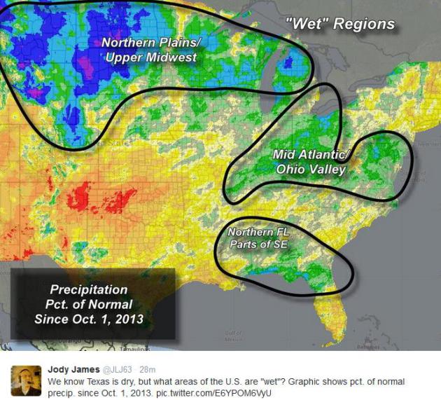
Moisture Haves and Have-Nots.
Jody James posted this NOAA image of precipitation departures since
October 1 of last year. The variations around the eastern half of the
USA are striking.
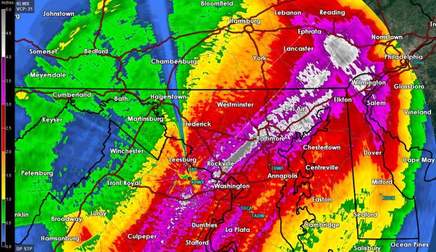
Mid Atlantic Soaking.
Here is a total rainfall update for Wednesday's soaking rains, showing
Doppler estimates as high as 4-6" from the suburbs of Washington D.C.
and Baltimore into the Delaware Valley.
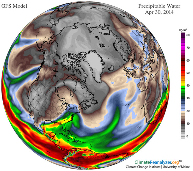
Tropical Plume.
The same stalled, retrograding storm responsible for record chill over
the northern Plains was able to pull a plume of truly tropical air
northward, which shows up on the precipitable water map above,
contributing to severe flooding from Mobile and Pensacola to Washington
D.C. The very slow forward motion of the storm also helped to prolong
rains, creating a "train echo effect" along the Gulf Coast, and much of
the Mid Atlantic from late Tuesday into Wednesday evening. Graphic:
ClimateReanalyzer.
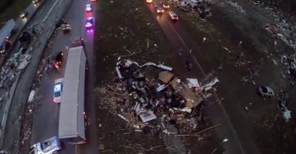
Tornado Chaser's True Story: "I Messed Up Big". This is why you really don't want to be in or near a vehicle when a tornado is approaching.
Mashable has the video clip and story; here's the introduction: "
A
Mississippi tornado chaser met his match on Monday when a massive
twister barreled directly over his car — while he was strapped inside.
Luckily, he survived the tornado that swept through Tupelo, Miss. Even
better, he filmed the whole thing. In the video, which was posted to YouTube
on Monday (and has now been made private), a man is seen driving
alongside a tornado, when he suddenly pulls off the road and into a
field..."
Tornado Drone Journalism, Raising First Amendment Questions.
Are you free to fly your personal drone over tornado wreckage, or any
other natural disaster? The FAA has some serious questions/concerns.
Here's an excerpt from
Forbes: "
Storm chaser and videographer Brian Emfinger used a drone to document the aftermath of a tornado that ripped through Arkansas. That video prompted speculation as
to whether the FAA was going to investigate or even fine Emfinger for
using the drone. Today, the Arkansas Democrat-Gazette is reporting ($0.99 paywalled) that the FAA is investigating the use of drones to gather aerial footage in Arkansas. about the agency’s ability to infringe upon press freedom in the absence of formal rules..."
Tornado Seasons Lately Have Been Boon Or Bust. Serious weather whiplash - applied to moisture, heat, and now tornadoes. Here's an excerpt of a story from AP and
ABC News: "
Something
strange is happening with tornadoes lately in the United States and
it's baffling meteorologists. It's either unusually quiet or deadly
active. Until this weekend's outbreak, the U.S. had by far the quietest
start of the year for tornadoes. By the beginning of last week, there
had been only 20 significant tornadoes and none of them that big. There
was also a slow start four years ago. And after a busy January, last
year was exceptionally quiet until a May outbreak that included a
super-sized tornado that killed 24 people in Moore, Okla. "When we have
tornadoes, we have lots of them," said Greg Carbin, warning
meteorologist for the Storm Prediction Center in Norman, Okla. "It's
boom or bust..." (file photo from Kent Nickell, in West Liberty, Kentucky).
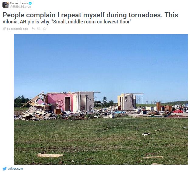
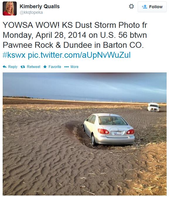
Pick Your Extreme: Biblical Flooding or Blowing Dust. Check out the photo from Kansas taken on Monday. Thanks to Kimberly Qualls for passing this one along via
Twitter.
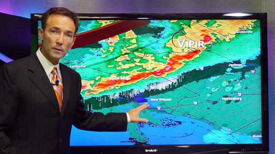
U.S. Slips To 4th Place In Global Weather Prediction, While A New Weather Service Supercomputer Has Not Been Ordered.
Part of the problem: IBM sold off their supercomputer line of business
to Lenovo, a Chinese company, and that has raised some very real
concerns - ultimately any supercomputer upgrade has to be approved by
the State Department and White House. A source who knows the details
tells me that 1). it's a lease, not a purchase, 2). NOAA does not
control the process and 3). the deal is larger than just NCEP
supercomputer.
Cliff Mass has the details in his blog; here's an excerpt: "
It is with considerable disappointment that I note that the U.S. has now slid into fourth place in global weather prediction. Yes,
the country that invented numerical weather prediction and the one that
possesses the largest weather research community in the world is moving
further back in the pack, with substantial costs to the American
people. And frustratingly, a powerful new weather supercomputer,
funded over a year ago by the U.S. Congress, has not even been ordered,
even though it could radically improve U.S. operational weather
prediction..."
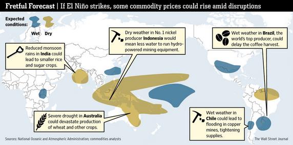
Markets Gird For Return Of El Nino. The Wall Street Journal
reports on the potential impact a moderate to strong warming phase of
ENSO might have on the commodity markets; here's a clip that caught my
eye: "...
an El Nino looms at a time when global supplies of many raw
materials already are stretched. Investors are loading up on
commodities futures contracts that would rise in value if global food
supplies are crimped further. Money managers hold more bullish than
bearish bets in all 16 major agricultural futures markets, according to a
Wall Street Journal analysis of data tracked by the U.S. Commodity
Futures Trading Commission. The last time that was the case was in June
2011, when prices in many commodity markets were near their highest in
decades..."
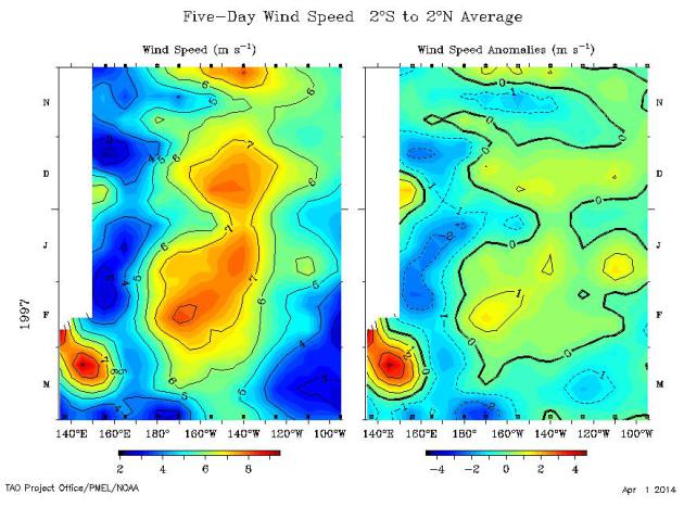
Comparing 1997 Super El Nino With 2014 El Nino Potential.
STORMSURF
has an amazingly thorough and comprehensive analysis of both the 1997
El Nino and the current 2014 El Nino underway in the Pacific, both
events preceded by Kelvin Waves signals. The comparisons are striking,
and although it's premature to estimate the strength of the current El
Nino there are strong similarities to 1997. Here's an excerpt: "...
All
the above data suggests this evolving 2014 event is of equal strength
to the 1997 event, if not stronger (as of the end of March 2014). The
fact that the 2014 event started a month earlier might bias the analysis
towards making it look stronger, if only in that it had more time to
evolve. But the fact that it started a month earlier in and of itself
could also suggest there was more latent heat energy built up in the
ocean compared to the 1997 event. Note that El Nino is just a means for
the ocean to vent off excess heat, serving much the same purpose as a
hurricane relative towards venting off excess lower atmospheric heat.."
Early Symptoms of El Nino?
I may be jumping the gun here (I am genetically capable of that), but
El Nino tends to energize the southern branch of the jet stream over the
USA, often resulting in more frequent and severe storms. It's
impossible to know if a brewing warm phase in the Pacific had any
influence on the record floods from Pensacola to Washington D.C.
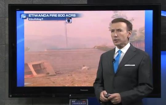
Wednesday. Out west the problem is drought, heat and high winds (clocked
as high as 100 mph) fanning wildfires. That's the subject of this
Climate Matters segment: "
Talk
about weather whiplash. WeatherNationTV Chief Meteorologist Paul
Douglas goes over wind and wildfires in Southern California & the
historic flooding and downpours over the Gulf Coast. What do the trends
say about the increasing threat for heavy rain?"
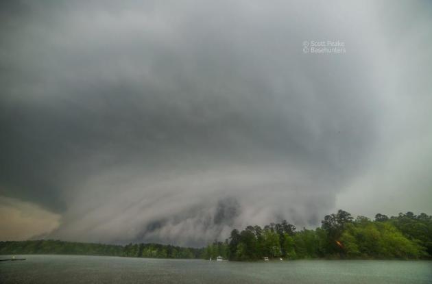
EF-4 Supercell.
Even though this is a still image you can see the powerful rotation in
this supercell thunderstorm, courtesy of Severe Studios and Kory
Hartman. Thanks to Scott Peak and
Basehunters for the share: "
Amazing photo from Basehunters of the Louisville, MS supercell that produced the EF-4 tornado as it was entering the southwest part of town Monday night!"
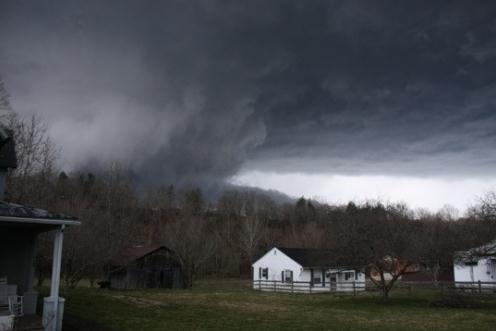
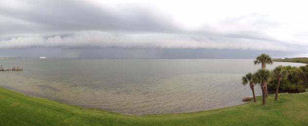
Shelf Cloud. Thanks to Jim Plucinak out of Cocoa Beach, FL for sending this in.
Lunch With Paul Douglas, Part 1. So is it a sit-down joint or just a drive-thru? Thanks to futurologist, astronomy buff and entrepreneur Jeffery Morris (ie.
FutureDude)
for spending some time with me recently, talking about weather,
technology and climate trends. Here's a clip from the interview where I
talk about how the future is just like the past, only with more apps and
less privacy: "...
I pictured the flying cars and the robotic
butlers. I used to daydream just like any other kid about what the
future would be like. It’s interesting how the future isn’t anything
like I thought it would be. It’s a little more mundane in many respects.
Our technology and productivity have certainly improved. One person can
now do unimaginable things in terms of research. You’ve got the world
at your fingertips with the net. And yet, we are still driving our
fossil fuel legacy cars. No robotic butlers. For me, the fun has always
been to try to look at the current trends. Trying to look over the
horizon and connect the dots, and make some educated guesses about where
specifically weather technology will be..."
Boat Believed To Be From 2011 (Japanese) Tsunami Washes Up On Washington State Shoreline. Here's an excerpt of a story from Fox31 in Denver,
kdvr.com: "
A
small boat that authorities believe to be from the 2011 Japanese
tsunami washed ashore along the Washington coast Monday morning. The
Ocean Shores Police Department told Seattle’s Q13FOX
that the boat was discovered off Ocean Lake Way and turned over to
Grays Harbor County officials. Deputy director of Grays County Emergency
Management Charles Wallace said the Department of Ecology plans to
inspect the watercraft Tuesday..."
Photo credit above: "
A small boat suspected to be from the 2011 Japanese tsunami was found on April 28 2014, washed ashore in Ocean Shores, Wash." (Photo: Karen Rasmussen via Ocean Shores Police Dept.)
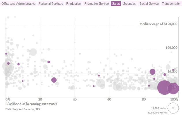
Here Come The Robots.
In the age of increasing automation and computerization some jobs are
more threatened than others. How vulnerable is your career to smart
robots in the years to come? The example above is for sales, which has a
high probability of being computerized in the future, according to
metrics highlighted in this story at
Quartz: "
In the second machine age, robots will perform tasks once thought to require uniquely human abilities, like driving our taxis and filleting our fish. But not all jobs will be equally affected by automation. The interactive plot above attempts to sort out the differences. We compared
three variables related to the American workforce: the median wage for
various jobs; the number of people employed in those positions in the
United States; and the likelihood that these jobs will become automated..."
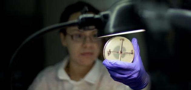
The "Post-Antibiotic Era" of Drug-Resistant Disease is Almost Here.
Right. Don't sweat the tornadoes or biblical floods. Remind me to never
leave my basement again. Here's the intro to a story at
The Wire: "
Get
ready to crawl into a hole, forever: Gonorrhea, urinary tract
infections, and pneumonia are just some of the infectious diseases that
are becoming resistant to antibiotics, a new report finds. The newly-released World Health Organization document
finds that in every region of the world, the growing rate of
antimicrobial and antibiotic resistance is a serious threat to human
health. Minor infections that were once considered beaten
could kill again, and lengthier stays in hospitals and higher healthcare
costs are a near-guarantee..."
Photo credit above: "Microbiologist Tatiana Travis in the Infectious Disease Laboratory at the federal Centers for Disease Control and Prevention." (AP / DAVID GOLDMAN)
Which Cities Spend The Most On Pampering Pets? No, the Twin Cities didn't make the cut. Miami is at the top of the list for some odd reason. Here's a clip from
Consumerist: "
The
list is on 2013 sales of pet-related items — from Mr. Whiskers’
favorite toy to Rover’s beloved brush. Does your fish have a ginormous
fish palace? That’s included too. According to Amazon’s list, the most
pampered cities for pets on a per capita basis, and in cities with more
than 400,000 residents:
1. Miami
2. Seattle
3. Atlanta
4. San Francisco
5. Portland, Ore.
6. Washington, D.C.
7. Las Vegas..."
TODAY: More light rain showers and sprinkles. Ducks are happy. Winds: NW 15. High: 49
THURSDAY NIGHT: Clouds, a few sprinkles. Low: 38
FRIDAY: Some sun, milder, with a passing shower or two. High: 58
SATURDAY: Mix of clouds and sun. Better. Wake-up: 40. High: 57
SUNDAY: AM shower south? Some sun. Wake-up: 39. High: near 60
MONDAY: Unsettled, risk of a shower. Wake-up: 43. High: 59
TUESDAY: Partly sunny, feels like spring again. Wake-up: 45. High: 64
WEDNESDAY: Milder, few T-storms possible. Wake-up: 50. High: 71


No comments:
Post a Comment