By Paul Douglas
Chances are you only remembered the last time your "favorite meteorologist" (oxymoron?) was wrong, not the majority of the time they were fairly close to the mark. Weather prediction will never be perfect, but things are moving in the right direction. Long-range accuracy is improving about 1 percent a year; today's 5-Day Outlook is about as accurate as a 3-Day forecast was for your parents.
Weather models predicted Sandy's land-falling "hook" 8 days in advance. The average lead time for tornado warnings has increased from 3 minutes in the 60s to 15 minutes today. In spite of spiking weather extremes fewer Americans are dying from wild weather, overall.
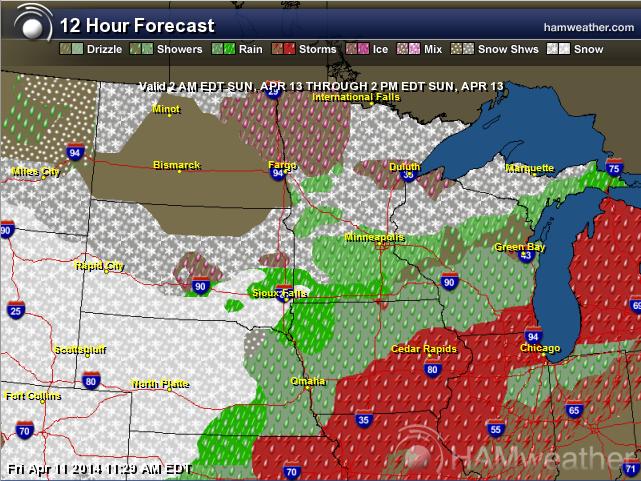
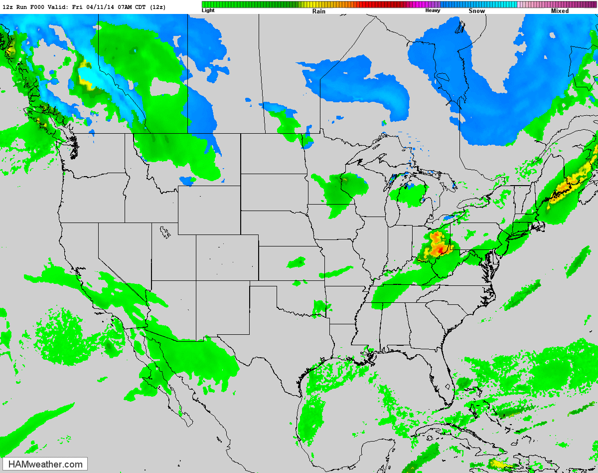
A round of heavy showers arrives Saturday, possibly punctuated by the first thunderclaps of 2014 in some communities. Models show precipitation passing just south & east of the Twin Cities Sunday and Monday; portions of Iowa and Wisconsin may get soaked with 2-3 inches of rain. I'm keeping an eye on it, because IF precipitation falls Sunday temperatures may be cold enough for a rain/snow mix. Insert gasp here.
Next week will be a poignant reminder that spring is always two steps forward, one step back. But no Polar Vortex.
===================================
FRIDAY NIGHT: Showers developing, possibly a rumble of thunder late. Low: 47
SATURDAY: Showers, rumble of thunder possible early. Some clearing later High: 66
SATURDAY NIGHT: Slight chance of showers. Low: 40
SUNDAY: Turning breezy and cooler with rain/snow mix possible across far southern MN. High: 43
MONDAY: March relapse. Gray and chilly. Few flakes? Wake-up: 28. High: 42
TUESDAY: Heavy jackets. Brisk. Wake-up: 26. High: near 40
WEDNESDAY: Breezy and milder. Wake-up: 27. High: 50
THURSDAY: Mostly cloudy, cool and damp. Wake-up: 34. High: 51
FRIDAY: Early shower, then clearing. Wake-up: 36. High: 52.
================================
This Day in Weather History
April 12th
1931: July-like temperatures across the area with 90 degrees at Beardsley in west central Minnesota.
================================
Sunrise/Sunset Times
April 12th
Sunrise: 634 AM
Sunset: 754 PM
================================
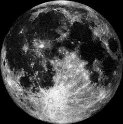
Moon Phase for April 12th at Midnight
2 Day Before Full (Pink) Moon
=============================
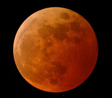
Lunar Eclipse of April 15, 2014
The full moon on April 15th, will also coincide with a Total Lunar Eclipse, which will be mostly visible in the Western Hemisphere. Keep in mind that there will be 4 eclipses in 2014, 2 solar and 2 lunar.
Here are the 2014 dates:
2014 Apr 15: Total Lunar Eclipse
2014 Apr 29: Annular Solar Eclipse
2014 Oct 08: Total Lunar Eclipse
2014 Oct 23: Partial Solar Eclipse
Here are the 2015 dates:
2015 Mar 20: Total Solar Eclipse
2015 Apr 04: Total Lunar Eclipse
2015 Sep 13: Partial Solar Eclipse
2015 Sep 28: Total Lunar Eclipse
Note that the four upcoming Lunar Eclipses are all "Total Lunar Eclipses" !! This set of four consecutive total lunar eclipses is known as a "Tetrad" - NASA has a great facts about how rare this particular sequence of total lunar eclipses is!
"The lunar eclipses of 2014 are the first of four consecutive total lunar eclipses - a series known as a tetrad. During the 5000-year period from -1999 to +3000, there are 4378 penumbral eclipses (36.3%), 4207 partial lunar eclipses (34.9%) and 3479 total lunar eclipses (28.8%). Approximately 16.3% (568) of all total eclipses belong to one of the 142 tetrads occurring over this period (Espenak and Meeus, 2009). The mechanism causing tetrads involves the eccentricity of Earth's orbit in conjunction with the timing of eclipse seasons (Meeus, 2004). During the present millennium, the first eclipse of every tetrad occurs sometime from February to July. In later millennia, the first eclipse date gradually falls later in the year because of precession."
See more from NASA.gov HERE:
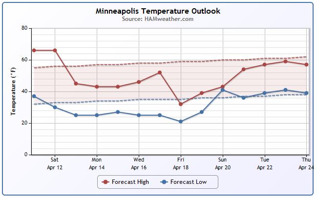
Minneapolis Temperature Trend
More like March... Unfortunately, we are going to take a bit of a set backwards in the temperature department over the next several days. Note that temperatures much of next week look to stay below average. The coolest weather may set in by the end of next week as we dip (potentially) into the upper 30s. Note that overnight lows are expected to dip into the 20s for the majority of next week too! This is just a reminder that, yes, it is still too early to start planting those annuals outside.
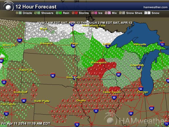
Saturday Weather Outlook
As a cold front sweeps out of Canada, weather conditions will sour over the weekend. From a wintry mix near the international border to heavy rain and thunder across parts of the Midwest/Great Lakes, this weekend won't be quite as pleasant as it was this week.
Sunday Weather Outlook
Sunday appears to be a little more active across the Midwest as the main low pressure system begins to develop and slide through the region. Note the wintry mess on the western and northern side of the storm where colder air is in place, while showers and storms will be possible on its southeastern flank.
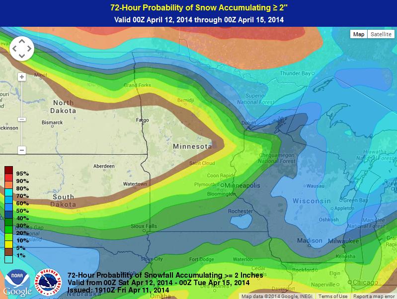
Snow Potential?
We're keeping an eye on the wintry precipitation potential across parts of the Upper Mississippi Valley. According to NOAA's HPC, the probability of at least 2" of snow or more is fairly low across much of Minnesota, but there still could be some slushy accumulations through early next week. Note that the darker blues indicate about a 40% chance of at least 2" of snow. Note that those chances are higher along the international border and into the Great Lakes Region.
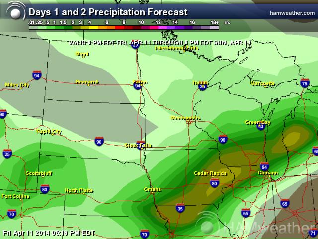
Weekend Precipitation Outlook
The precipitation outlook through PM Sunday looks quite heavy from the Midwest to the Great Lakes Region. Note the 2"+ potential from near Kansas City, MO to Milwaukee, WI to near Grand Rapids, MI.
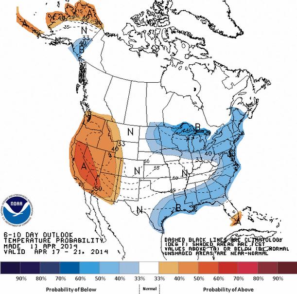
6 to 10 Temp Outlook
According to NOAA's CPC, the 6 to 10 day temperature outlook, the eastern part of the country sill has a shot at below average temperatures through the middle part of April, while the western part of the country will remain well above average.
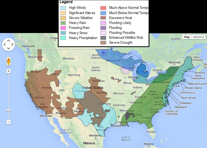
3-7 Day Hazards
This is an interesting map from NOAA, which shows the potential weather hazards over the next 3 to 7 days across the nation. Note that the Upper Midwest/Great Lakes Region will have much below normal temperatures, while the eastern third of the nation is expected to get heavy rain/precipitation. Meanwhile, severe drought continues in the Southwest and Plains. Unfortunately, coupled with high winds in the Southern Plains, fire danger could be a common issue here.
See more from NOAA HERE:
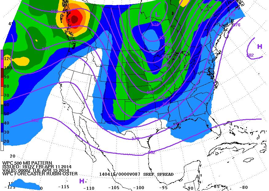
Turning Colder
Memories of March continue as we head into early next week. Take a look at the huge dip in the upper level winds as we head into early next week. This weather feature will draw down significantly colder than normal air for this time of the year. This "stormy" pattern will also help to bring more widespread precipitation to places in the central and eastern part of the country.
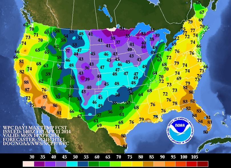
Highs Monday
Here's a glance at Monday temperatures and note how cold it looks in the central part of the country!
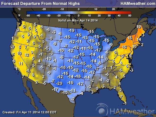
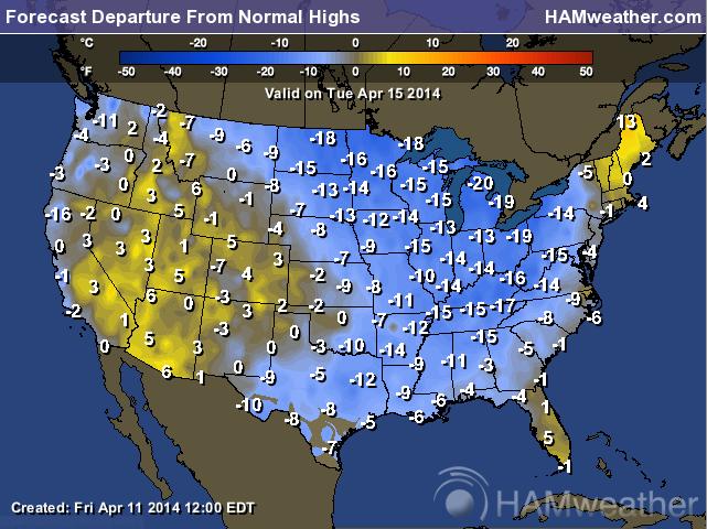
Highs From Normal Monday
For April standards, Monday will be significantly colder than normal in the central part of the country. In fact, temperatures may be a good 10F to 20F below average!
Highs From Normal Tuesday
By Tuesday, this colder air will be in place across the eastern two-thirds of the nation!
Weather Outlook
The colder air moving into the eastern two-thirds of the nation by early next week will be dropping in on the backside of a developing storm system. Take a look at the weather loop below and note the storm system in the Midwest/Great Lakes Region by Sunday. Also note the wintry precipitation on the northern and western flank of this developing storm.
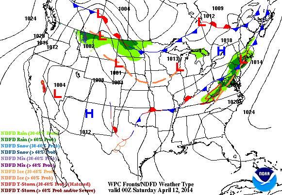
Weather Outlook Continued
Here's another look at the developing storm system as it develops through early next week. This classic looking spring storm will likely bring accumulating snow to some and severe weather to portions of the central part of the country.
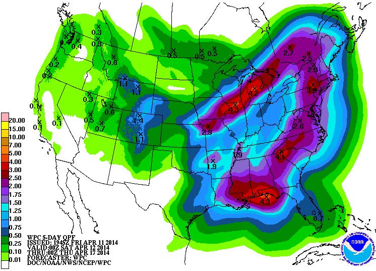
Precipitation Outlook
According to NOAA's HPC 5 day precipitation outlook, the developing storm system from late weekend into early next week looks to bring significant moisture across parts of the eastern half of the country. The Midwest/Great Lakes and portions of the Gulf Coast States could see the heavies tallies, which could also be conducive of flooding.
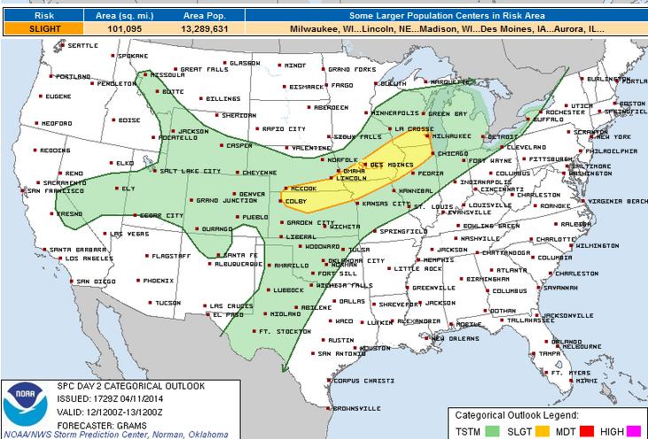
Severe Threat Saturday
The severe threat Saturday looks fairly minimal, but there appears to be enough instability during the PM hours along the leading edge of a cold front as it moves southeast through the Midwest. Hail and high winds look to be the primary threat with this particular system.
THE MOST PROBABLE REGION FOR DIURNAL STORMS SHOULD BE FROM THE UPPER MS VALLEY TO CNTRL GREAT LAKES IN ASSOCIATION WITH A LEAD SHORTWAVE IMPULSE AND CYCLONE. A CLUSTER OF ELEVATED CONVECTION SHOULD BE ONGOING AT 12Z/SAT ON THE NOSE OF A ROBUST SWLY LLJ. MOISTURE TRANSPORT SHOULD YIELD SURFACE DEW POINTS INCREASING INTO THE 50S TO AT LEAST SRN WI AND IL. SURFACE-BASED DEVELOPMENT SWWD ALONG THE FRONT/TRAILING OUTFLOW SHOULD OCCUR BY LATE DAY FROM CNTRL IA NEWD. STRONG DEEP-LAYER SHEAR AND STEEP MID-LEVEL RATES WILL PROMOTE ROTATING UPDRAFTS CAPABLE OF ALL SEVERE HAZARDS. BUT WITH MEAN WINDS GENERALLY PARALLELING THE FRONT...LINE-ORIENTED CLUSTERS SHOULD BECOME THE PREDOMINANT MODE WITH SEVERE HAIL/WIND AS PRIMARY HAZARDS.
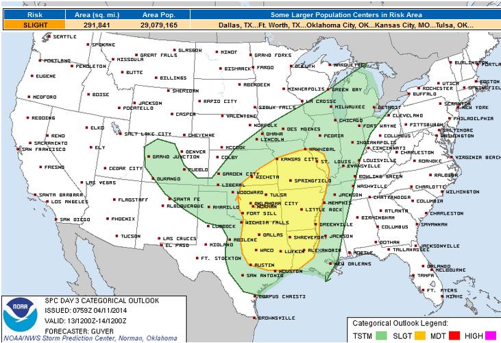
Sunday Severe Threat
By Sunday, our main area of low pressure will begin to move into the central part of the country, so the dynamics begin to become more interesting. Severe weather concerns will be ramping up by PM Sunday and Monday as the storm takes shape a little more. At this point, there is a large section of the middle part of the country that could see strong/severe storms on Sunday.
AS THE AIR MASS DESTABILIZES THROUGH AFTERNOON...AMPLE FORCING FOR ASCENT TIED TO THE AFOREMENTIONED SHORTWAVE TROUGH AND COLD FRONT SHOULD INFLUENCE INCREASING TSTM DEVELOPMENT PARTICULARLY SUNDAY AFTERNOON/EVENING. GREATER CERTAINTY FOR STRONGER DEEP CONVECTIVE DEVELOPMENT WILL BE NEAR THE ADVANCING COLD FRONT ACROSS PARTS OF OK/SOUTHEAST KS AND ADJACENT MO/KS. HOWEVER...OTHER MORE DISCRETE STRONG/SEVERE STORMS INCLUDING SUPERCELLS WILL BE POSSIBLE ACROSS ADDITIONAL PARTS OF EAST-CENTRAL TX/ARKLATEX WITHIN THE PRE-FRONTAL WARM SECTOR AND NEAR THE DRYLINE EXTENDING SOUTHWARD ACROSS SOUTH-CENTRAL OK INTO NORTH-CENTRAL/CENTRAL TX. FAVORABLE WIND PROFILES WILL SUPPORT INITIAL SUPERCELLS...ALTHOUGH INCREASINGLY UNIDIRECTIONAL WINDS /VEER-BACK-VEERING WINDS WITH HEIGHT/ AND THE INFLUENCE OF THE COLD FRONT SUGGEST THAT MULTICELLS/LINE SEGMENTS SHOULD EVOLVE DURING THE EVENING IN MOST AREAS...WITH NEAR-COLD FRONTAL STORMS STEADILY BEING UNDERCUT BY THE COLD FRONT /FROM NORTHWEST TO SOUTHEAST/. LARGE HAIL IS EXPECTED TO THE PRIMARY HAZARD OVERALL...ALTHOUGH DAMAGING WINDS AND SOME TORNADOES MAY BE POSSIBLE AS WELL.
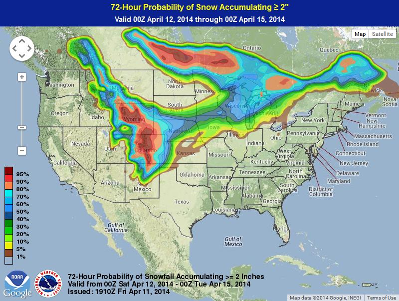
Winter Weather Potential
There is a growing snow potential for a number of locations through Monday evening. The graphic below suggests the probability of at least 2" of snow or more. Note that areas along the Rockies/Front Range have the best potential. Note how there is also a fairly decent chance that some light accumulations may be possible across parts of the Midwest/Great Lakes Region and also across the international border.
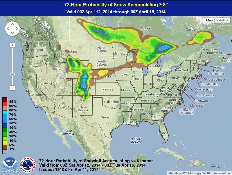
Probability of 8"
The probability of at least 8" of snow or more drops significantly over this time, but the best chance still exists over the higher elevations in the Central Rockies.
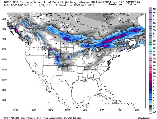
Snow Potential
Here's the GFS (American model) suggested snowfall accumulation through AM Tuesday.
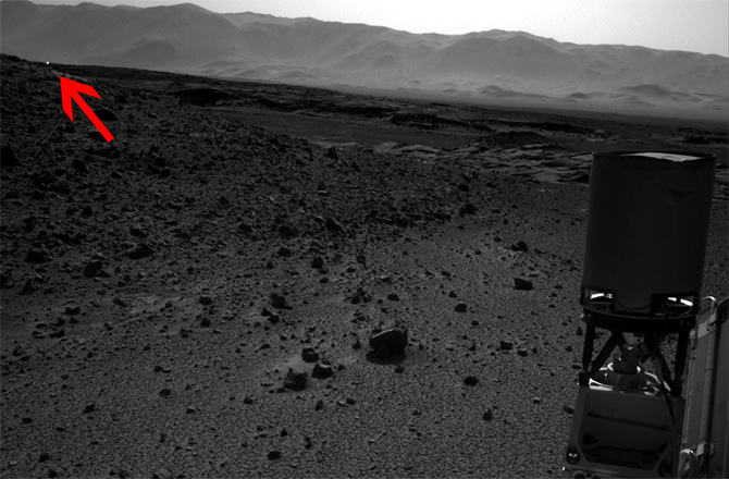
Mystery on Mars?
NASA's Mars Rover Curiosity captured a pretty interesting beam of light earlier this week. There have been several conspiracies out there, but NASA suggests that it is likely sun glint!
"In a NASA news release late on Tuesday, a member of the team that built and operates the rover’s Navigation Camera (Navcam) outlined the most likely causes of the bright dot — a feature that isn’t all that rare in Curiosity’s raw imagery beamed back to Earth.
“In the thousands of images we’ve received from Curiosity, we see ones with bright spots nearly every week,” said Justin Maki of NASA’s Jet Propulsion Laboratory, Pasadena, Calif. “These can be caused by cosmic-ray hits or sunlight glinting from rock surfaces, as the most likely explanations.”
This official word builds on the preliminary theories as to what the bright dot is in a photo taken on Sol 589 (April 3) of Curiosity’s mission."
Read more from Discovery.com HERE:
Thanks for checking in and have a great weekend ahead! Don't forget to follow me on Twitter @TNelsonWNTV

No comments:
Post a Comment