54 F. high in the Twin Cities Friday.
69 F. average high on May 16.
83 F. high on May 16, 2013.
May 16, 1915: Old Man Winters last hurrah with 5 inches of snow along Lake Superior. Source: NWS.
Frost Advisory early this morning includes MSP metro.
70 F. by Sunday afternoon.
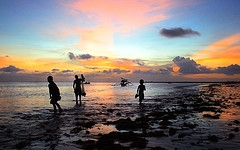
Sunburned Goosebumps
The
Summer Solstice is a little over a month away, at least on paper. The
tendency to tan (or burn) has nothing to do with air temperature, and
everything to do with the sun angle overhead. Yes, it is theoretically
possible to get a painful burn with temperatures in the 40s or 50s.
I'm
so confused. So is the atmosphere sloshing over North America. A frost
advisory in the metro, snow in Duluth? Flooding rains east of the
Mississippi, while California endures the worst drought since the 1920s
and Texas muddles through one of the 5 worst droughts in 500 years.
The United States of Extremes.
Dr.
Mark Seeley says 73 percent of the days in 2014 have been cooler than
average. If we don't see 80s until June it would be the first time since
1983.
Look at the bright side: our weather has to get better, and
it will. The sun peeks out today; 60s Sunday and 70s on Tuesday.
T-storms are likely Monday, but we should dry out by midweek with
temperatures closer to average. Memorial Day weekend comes early this
year. I'm happy to report it won't snow, in fact ECMWF models shows 70s
next Friday, Saturday and Sunday with blue sky - maybe a few T-storms by
Memorial Day.
Better late than never.
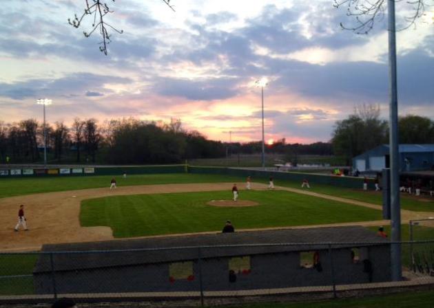
* file photo above courtesy of St. Olaf.
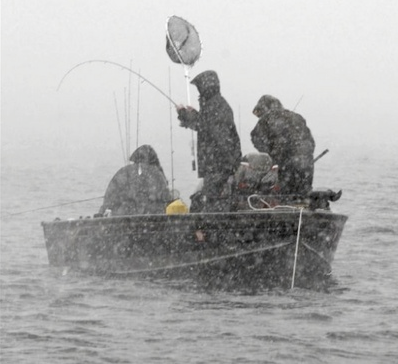
Baseball or Football Weather?
Thanks to Hollanders Baseball in Cologne and WeatherNation
meteorologist Bryan Karrick for reminding us that, in spite of a cool,
damp spring, life & baseball goes on.
Spring In Your Step.
We've been in an abusive relationship with Mother Nature for much of
the last 6 months, but there are (finally) signs of a prolonged,
extended warming trend. Temperatures flirt with 70F Sunday, pushing well
into the 70s next Tuesday, maybe a few days of 70s
in a row Memorial Day Weekend. 80s? Don't get greedy.
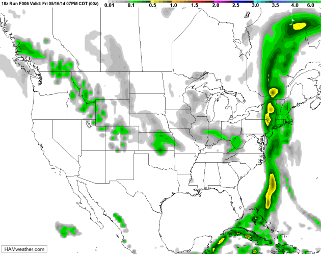
Northward Shift In The Jet Stream.
GFS guidance shows a big cool-down over New England, instability
showers lingering much of the weekend. A few showers and heavier
T-storms may drop badly-needed rain on Texas and the southern Plains
early next week - an advancing warm front sparking T-storms for
Minnesoeta and Wisconsin Monday. Showers brush far northern California,
but I still don't see any rain for central and southern California,
where the wildfire risk remains off the scale. Loop: NOAA and
HAMweather.
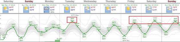
Latest 80-Degree Temperature In The Twin Cities?
We've only seen 3 days of 70s so far in 2014 here in the Twin Cities;
no 80s just yet. How unusual is this, and will we set a (regretable)
record for the latest 80-degree temperature on record in the metro?
Here's an excerpt of an answer from Minnesota climate guru Dr. Mark
Seeley at
Minnesota Weathertalk: "...
Since
1873 there have only been 10 years when spring did not bring an 80
degrees F temperature to the Twin Cities until the month of June, the
last of which was 1983 (first reading of 80 F for the year on June 8th).
The latest ever first reading of 80 degrees F or higher in the Twin
Cities climate record occurred on June 16th in both 1878 and 1883."
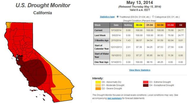
All of California in Severe Drought For First Time This Century.
USA Today
has details on the fire threat, water shortages and deepening drought -
here's a clip that caught my eye: "...Svoboda calls the current drought
once in a generation; the most comparable recent one would be the
drought of 1976-77. But the impacts today are more intense because the
state's population has doubled since then while the state's water supply
has remained fixed, he said. Svoboda said the only other California
drought similar to today's was during the 1920s. But the state's
population then was 1/10th of what it is now..."
* latest California U.S. Drought Monitor details
here.
Entire State of California Facing Worst Drought Since Tracking Began.
Time.com has an update on the drought and wildfire risk, which just keeps getting worse with each passing day; here's an excerpt: "
The
entire state of California is suffering the most intense drought since
the federal government began monitoring drought levels in 2000.
Wildfires in the south have burned down at least 30 homes, in an
"unprecedented" intensity, climatologist Mark Svoboda said. The entire
state of California is facing a “severe” drought or worse for the first time since tracking began in 2000, according to the federal U.S. Drought Monitor..."
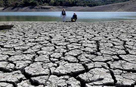
Photo credit above: "
Cracks in the dry bed of the Stevens Creek Reservoir in Cupertino, Calif., on March 13, 2014."
Marcio Jose Sanchez—AP.
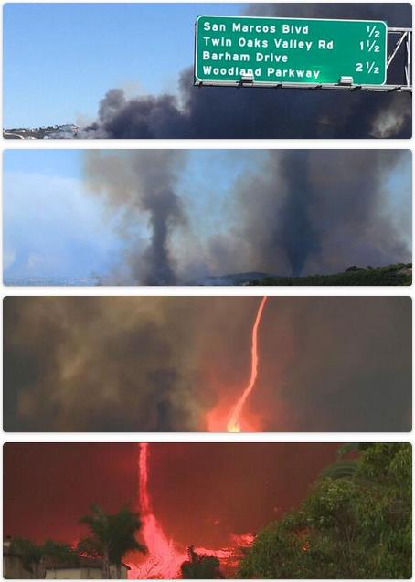
The Science Behind The Amazing, Terrifying Firenadoes in California. Meteorologist Eric Holthaus has a good explanation at
Slate; here's an excerpt: "...“
Firenadoes,” like those shown above (and in video, here)
are actually fairly common in intense wildfires. Here’s the science:
Fires obviously generate a lot of heat, and heat rises. Heated air rises
even faster when surrounded by relatively cooler air on the edges of
major fires, and vortexes can form in particularly strong updrafts. If
those vortexes contain flame, you’ve got yourself a firenado..."
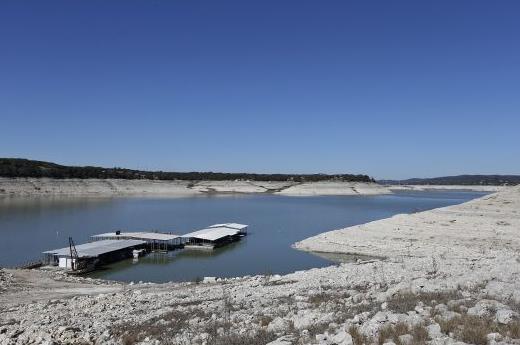
Drought Among The Worst In Texas In Past 500 Years. Here's an excerpt from a story at
The Houston Chronicle: "
Will
record-breaking droughts become the “new normal” for South Texas? That
question was posed by the state Climatologist John Nielsen-Gammon at a
meeting of the Edwards Aquifer Authority
board Tuesday. The current drought, which started four years ago, is
among the five worst in the past 500 years, he said. If it continues to
be as dry as it is has been, the drought could be the third worst..."
Photo credit above: "Jerry Lara/San Antonio Express-News. "
The Red Cove Marina still floats on water as Medina Lake levels continue to drop, Tuesday, Feb. 4, 2014."
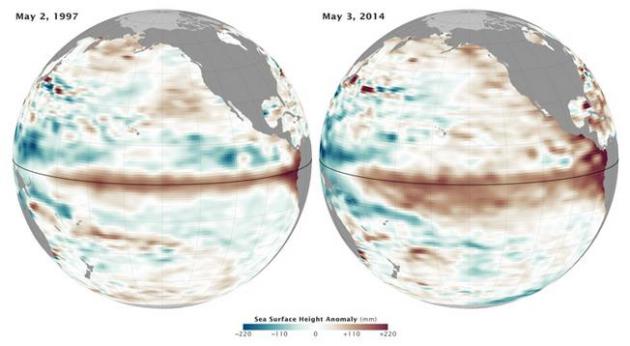
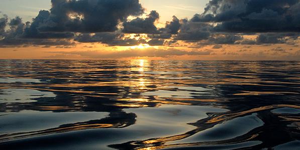
The Rise of El Nino in One Swell Image. The probability of a potentially significant El Nino warming phase has risen to 65% - here's an excerpt from an update at
Climate Central: "
El Niño gawkers, rejoice. A new set of imagery provides an unmistakable view of the El Niño conditions that appear to be developing. On Tuesday, NASA’s Earth Observatory
released a map showing ocean heights in the tropical Pacific in early
May compared to May 1997, the year an El Niño formed against which all
other El Niños are measured.
That year’s El Niño helped fuel extreme weather around the globe and
contributed to 1998 being one of the warmest years in recorded history..."
Image credit above: "
A
map showing ocean height anomalies in early May 2014 compared to early
May 1997. Reddish brown indicates ocean heights that are higher than
normal while green indicates lower then normal ocean heights." Credit: NASA Earth Observatory.
What The Death of Homepages Means For The Future of News. The New York Times may have lost 80 million homepage viewers - half the traffic to
nytimes.com
- in two years. Derek Thompson describes what this means for
traditional news sites and how the rise of social media (taking us to
specific story links) is complicating the aggregation of eyeballs in the
news world. Here's an excerpt of his story at
The Atlantic: "...
News
publishers lost the homepage firehose, and gained a social media flood.
This social flood corresponds with the emergence of another powerful
piece of technology: audience analytics software that tells digital
publishers what people are reading, and how long they're reading it,
with greater specificity than ever. One theory is that the rise of twin
technological forces—the social flood and the age of analytics—will (a)
make the news more about readers; and (b) make news organizations more
like each other..."
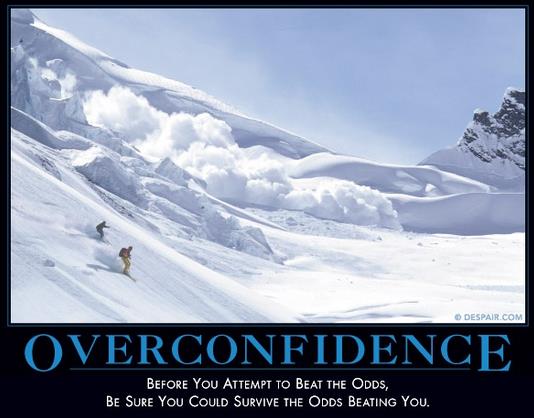
It Pays To Be Overconfident, Even When You Have No Idea What You're Doing.
You probably live this on a day to day basis - interacting with people
who pretend they have the answer key, when they truly have no idea what
they're doing? It's an epidemic. Here's an excerpt from
nymag.com: "...
In 2012, Cameron Anderson at Berkeley and his colleagues published a paper supporting
this idea, showing that overconfidence increases one’s status. Subjects
who overestimated their abilities at group tasks were more respected
and influential in the group. It turns out, we tend to (over)use
confidence as a useful proxy for competence — if you speak firmly, it
sounds like you know what you’re talking about. People who showed more
confidence, regardless of their actual ability, were judged to be more
capable and accorded more regard by their peers..." (Image: despair.com)
Cats And Dogs, Dressed as People, 100 Years Ago. We don't need no stinking Internet to dress up our pets! Here's a photo essay and article at
The Atlantic that proves this maxim: "...
Photographer
Harry Whittier Frees, born in 1879, began a career in cute-animal
photography in 1906, building out a small studio to produce postcards,
calendars, and children's books. While I was researching World War I
events on the Library of Congress website, I stumbled across a
collection of Frees's work from June of 1914, and just had to share. The LOLcat is not a new phenomenon..."
Photo credit above: "
The fiddler."
(Harry Whittier Frees/Library of Congress).
TODAY: Frost Advisory early. Partly sunny, feeling better about spring by afternoon. Winds: W 5-10. High: 61
SATURDAY NIGHT: Partly cloudy and cool. Low: 44
SUNDAY: Intervals of sun, milder. High: 69
MONDAY: Showers and heavy T-storms likely. Wake-up: 51. High: 67
TUESDAY: Damp start, then clearing and warmer. Wake-up: 58. High: 76
WEDNESDAY: More sun, less humid. Wake-up: 57. High: 69
THURSDAY: Mix of clouds and sun, lukewarm. Wake-up: 55. High: near 70
FRIDAY: Plenty of sun. "Pleasant". Really. Wake-up: 54. High: 73
Climate Stories....
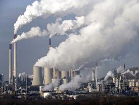
World's Top Companies Already Feeling Impacts of Climate Change. Bloomberg Businessweek has the story; here's a clip: "
Drought,
hurricanes and rising seas are becoming more significant threats to the
world’s biggest companies and the risk is accelerating, according to
the Carbon Disclosure Project. Companies planning for various threats
related to climate change say they’re grappling now with about 45
percent of the potential risks, or will be within five years, according
to a report issued today by the London-based non-profit group. That’s up
from 2011, when members of the Standard and Poor’s 500 Index expected
26 percent of the potential risks to affect them within five years..." (File photo: Wikipedia).
8 Pseudoscientific Climate Claims Debunked By Real Climate Scientists.
Billmoyers.com has the complete list; here's an excerpt of the skeptical claim that "heating has stopped since 1998": "...
What’s
going on? “1998 was the warmest year in the last century,” explains
Kevin Trenberth, a distinguished senior scientist in the Climate
Analysis Section of the National Center for Atmospheric Research. “There
was a big El Niño event in 1997 and 1998, and we have a lot of evidence
that there was a lot of heat coming out of the ocean at that time. So
that’s the real anomaly — the fact that we had what was perhaps the
biggest El Niño event on record.” “That’s one of the cherrypicking
points for deniers — they take the highest value and then compare it”
with lower points in the natural temperature fluctuation we know as
“weather...”
Warning Signs. Why The Struggle Over Climate Is Moving To The Executive Branch. National Journal has the article; here's the introduction: "
Miami
will likely be underwater before the Senate can muster enough votes to
meaningfully confront climate change. And probably Tampa and Charleston,
too—two other cities that last week's National Climate Assessment
placed at maximum risk from rising sea levels.
Even as studies proliferate on the dangers of a changing climate, the
issue's underlying politics virtually ensure that Congress will remain
paralyzed over it indefinitely. That means the U.S. response for the
foreseeable future is likely to come through executive-branch actions,
such as the regulations on carbon emissions from power plants that the
Environmental Protection Agency is due to propose next month. And that
means climate change will likely spike as a point of conflict in the
2016 presidential race..."
Climate, God and Marco Rubio. Here's an excerpt of an Op-Ed at
The Hill: "...
St.
Bonaventure, a Franciscan theologian, described the created universe as
the fountain fullness of God’s expressed being. As God is expressed in
creation, creation in turn expresses the creator. Rubio’s God must not
be one of endless love. What kind of a God would create such a
beautiful, wondrous creation filled with such awesome beauty only to
later change his mind and allow it to be destroyed? What it is about our
nature that allows us to believe it is okay to destroy our planet? Do
we not feel “the extinction of a species as a painful disfigurement?”
Does Rubio not see the divine beauty in all of creation? Could it be
that we have become so isolated, so focused on the individual that we
have lost sight of our connectedness, our relationship to God, and all
that God has created?..."

No comments:
Post a Comment