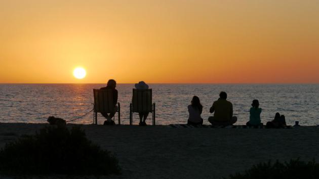
84 F. high in the Twin Cities Thursday.
73 F. average high on May 29.
76 F. high on May 29, 2013.
May 29 in Minnesota Weather History. Source: Twin Cities NWS.
1998:
Devastating line of storms hits east central Minnesota. 100 mph winds
in Scott and Dakota County. Over 500 homes damaged in Washington County.
15,000 trees lost in the Twin City metro area. 500,000 without power in
Minneapolis.
1985: Tornado hits Lakefield. The Twin Cities report 67 mph winds.
Weather Amnesia
A
friend of mine at the office explained a recent epiphany. "I rode my
bike to work - blue sky, gentle breezes, chirping birds - for a few
precious minutes I almost forgot about our nasty winter" he sighed.
One
female friend compared the last 6 months to the meteorological
equivalent of childbirth. That may be a stretch, but I get her point.
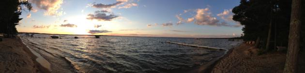
Our on-again, off-again spring has given way to a fast-forward summer, with all the 'fixins.
Mid-80s
will lure you outside again today; no chance of red blobs showing up on
Doppler. Take advantage of a quiet sky because a stalled frontal zone
will spark a sloppy parade of showers and heavier T-storms from Saturday
afternoon into Tuesday of next week. NOAA models predict some 2-3 inch
rainfall amounts by the middle of next week; heaviest amounts over
central and northern Minnesota, where many waterlogged farmers are
already hurting from incessant rains and muddy fields.
A brewing
El Nino favors a wetter, slightly cooler summer for Minnesota and most
of the Upper Midwest; we'll see if that semi-educated guess pans out.
Hurricane season kicks off Sunday, and the GFS model still tries to bring a tropical system into Florida late next week.
No storms with names for Minnesota.
.96" of rain forecast from Saturday afternoon into early Monday at KMSP. (NAM model).
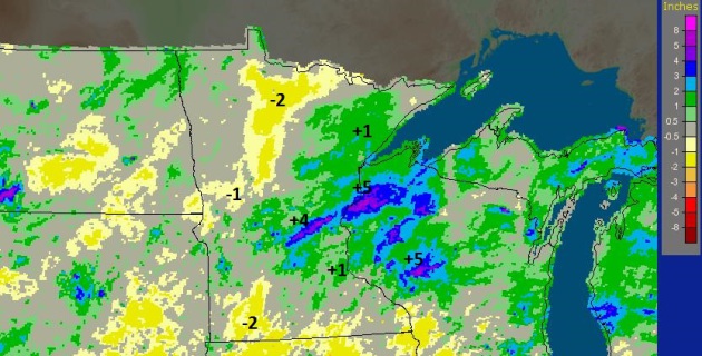
30 Day Rainfall Departures.
Much of the Twin Cities metro has seen 1-2" more rain than average
since late April, a band of +4-5" departures from near Little Falls to
Sandstone and much of western Wisconsin. While farms over far southwest
and north central Minnesota are running a 2" rainfall deficit over the
last 30 days.
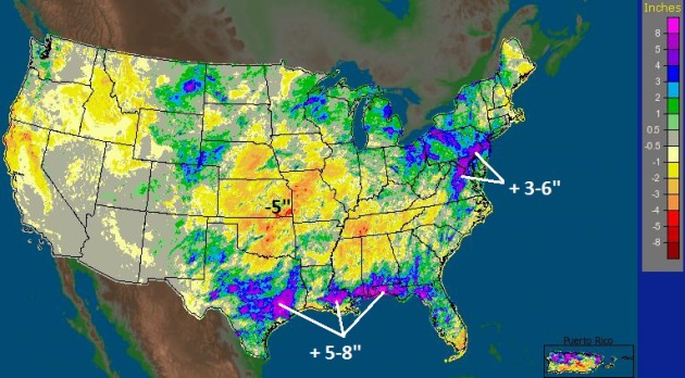
Fickle (Torrential) Rains.
Rainfall deviations are as much as 5-8" above average (for just the
last 30 days!) from near Houston to New Orleans, Mobile and the Florida
Panhandle, the I-95 corridor from Washington D.C. to New York has picked
up as much as 3-6" more than than average since April 29. Source: NOAA.
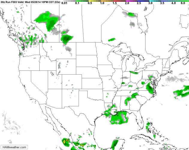
84 Hour Future Radar.
Data from NOAA's NAM model and HAMweather shows a cool front stalling
over the Upper Midwest over the weekend, acting as a focal point for
scattered showers and heavy T-storms. Meanwhile a persistent cyclonic
circulation keeps torrential rains over the Lower Mississippi Valley; a
storm off the east coast keeping New England in a cool northerly flow
through the period.
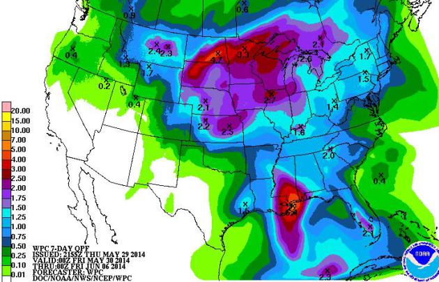
More Gulley-Washers.
NOAA's 7-Day rainfall guidance shows as much as 2-4" of rain from the
Dakotas into northern and central Minnesota and Wisconsin; more heavy
T-storms from the central Plains into the Lower Mississippi Valley,
where some 5-8" amounts are possible. While the southwest remains
bone-dry.
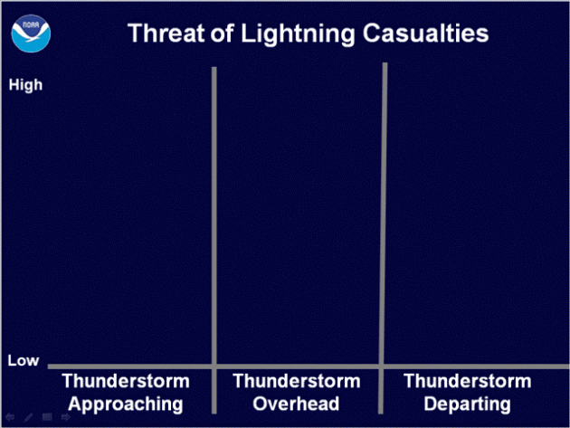
Lightning Risk.
It may seem counterintuitive, but the threat of being struck by
lightning is greatest prior to, and just after heavy rain associated
with thunderstorms. All thunderstorms, by definition, produce
potentially deadly cloud to ground lightning, and many people are struck
immediately before, and after the storm hits. Just because it's not
raining doesn't mean the threat is low - lightning can travel up to 10
miles from the parent thunderhead. Here's an excerpt of a good
explanation from
NOAA: "
In
the first graph, the threat of lightning increases as a thunderstorm
approaches, reaches a peak when the storm is overhead, and then
gradually diminishes as the storm moves away. At the same time, it’s
people’s behavior that determines the risk of a fatal lightning strike.
While some people move inside at the first signs of a thunderstorm, many
people wait far too long to get to a safe place. Some wait until the
thunderstorm is overhead and it starts to rain. Others, due to poor
planning, are caught outside and can’t get to a safe place. Although
most people got inside, some put themselves at risk by touching items
that could become electrified by a nearby lightning strike. Finally,
many people go outside too soon after the storm has seemingly passed,
often only waiting for the rain to become lighter or end. It is all of
these unsafe behaviors that put people at risk when thunderstorm are
in the area..."
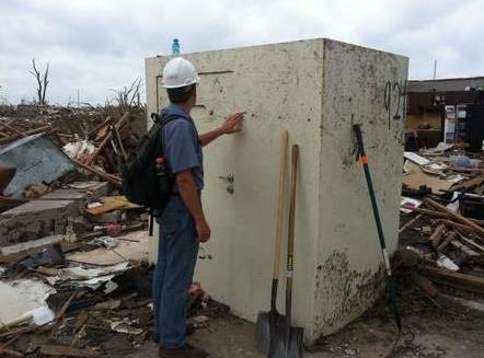
Effective Tornado-Proof Houses and Rooms: Can They Be Built?
Given enough steel-reinforced concrete it's possible to make any
building more tornado-resilient, although tornado-proof may be wishful
thinking. But can reinforced "safe rooms" be added which will withstand
most tornadoes? Here's an excerpt of a story at The Washington Post's
Capital Weather Gang: "...
By
the way, it bears repeating (from the earlier post) that even the
relatively small expense of a safe room might seem unnecessary to some,
as statistics have shown that even in tornado alley, the chances of a
particular home being struck by a tornado during its rated life span of
50 years is only about 1%. On the other hand, keep in mind that if you
are in that 1%, the destructive force of a 150 mph wind is not 3 times
that of a 50 mph wind—it’s more like 9 times! And in case you’re
wondering, the Texas Tech Wind Science and Engineering Research Center
has grave misgivings about remote underground shelters—even though
they’re in considerable use–because people tend to wait until the last
possible minute before taking refuge, thereby subjecting themselves to
flying debris, etc.)..."
File photo: Andrew Graettinger, University of Alabama.
Tornado Titillation or Public Service?
So is airing tornado footage, after the fact, a good idea? Does it
tempt others, without training or experience, to rush headlong into
supercells with iPhones held high, tempting fate in the process? There's
anecdotal evidence that streaming LIVE tornado footage from webcam,
spotters or chasers confirms the fact that there's a life-threatening
storm moving in, prompting people to take action and head for the
basement or another shelter. I asked
Severe Studios founder Kory Hartman for his thoughts in the wake of the (reckless) tornado footage from Watford City, North Dakota: "
El
Reno killed some of the best and most knowledgeable chasers of all
time. If that somehow inspires people to grab a Camaro and a camcorder
and go flying after storms at 90mph with no experience, then God help
them." He added "
live video is very valuable as the "social
science" confirmation that a tornado is heading toward a person's house.
The video of chasers getting hit by tornadoes should be a "caution" to
people. After El Reno, most of my chasers have learned to leave earlier,
have more escape routes, stay to the south/southeast of the storm, take
others with for navigation, etc."
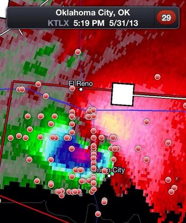
* image above is a Doppler radar velocity field showing the enormous
EF-5 tornado
that hit El Reno, Oklahoma on May 31, 2013, killing at least one
amateur storm chaser and 3 tornado research veterans, including Tim
Samaras. The red dots are locations of storm spotters relative to the
tornado vortex.
Hurricane Forecasters: Unpredictable Paths to Fame. Here's an excerpt from AP and
The Houston Chronicle: "
We
see them on TV, braving tornadoes and hurricanes and flooding.
Delivering the weather has put a whole new group of celebrities on the
national radar: meteorologists. But what path did they take to become so
well known? For some, it was a childhood obsession with storms; for
others, it was a fortuitous but unpredictable turn of events With the
Atlantic hurricane season opening Sunday, here are three of the nation's
most well-known meteorologists and how they reached the top of their
field..."
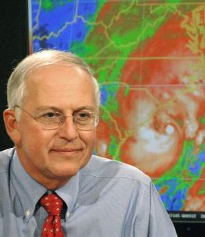
File photo above: Andy Newman/AP. "
In
this Aug. 31, 2006 file photo, National Hurricane Center director Max
Mayfield briefs a Charleston, S.C., television audience on the progress
of Tropical Storm Ernesto, at the hurricane center in Miami. Delivering
the weather has put a whole new group of celebrities on the national
radar: meteorologists. Mayfield, the retired director of the National
Hurricane Center in Miami, became an accidental TV personality following
Hurricane Katrina in 2005."
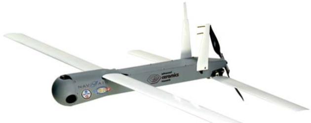
Researchers Turn To Drones To Gather Hurricane Information.
Because drones can capture real-time data that Hurricane Hunter
aircraft can't. Here's an excerpt of a great article from AP and
Longview's
News-Journal: "...
Hurricane
hunter aircraft typically don’t fly below 5,000 feet and can’t descend
below 1,500 feet, and real-time radar doesn’t provide information about
the thermodynamics at work inside a storm’s cloudy core. Canisters
stuffed with electronics dropped from the planes transmit data about a
storm’s pressure, temperature, winds and moisture as they fall to the
ocean, but they remain airborne for only a few minutes. The kind of
drone that Cione plans to launch from the hurricane hunters will spend
hours descending slowly, cruising on the air currents spinning through a
storm, possibly even orbiting a hurricane’s eyewall..."
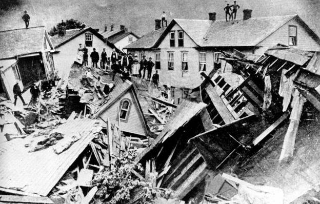
125 Years After Johnstown: Facts About The Flood. Here's a snippet of an interesting piece from AP and
seattlepi.com: "
A
privately owned dam collapsed in western Pennsylvania 125 years ago on
May 31, 1889, unleashing a flood that killed 2,209 people. The terrible
stories from the Johnstown Flood of 1889 are still part of lore because
of the gruesome nature of many of the deaths and the key role it played
in the rise of the American Red Cross. Here's some of what's known about the flood, one of the deadliest natural disasters in U.S. history..."
File photo credit: "
In
this 1889 file photograph, people stand atop houses among ruins after
disastrous flooding in Johnstown, Pa. Facts, figures and anecdotes about
the Johnstown flood in Pennsylvania, which killed 2,209 people 125
years ago, gave the Red Cross its first international response effort
and helped set a precedent for American liability law." Photo: Uncredited, AP.
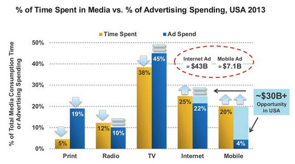
Mobile Is Eating Global Attention: 10 Graphs on the State of the Internet. Here's an interesting article at
The Atlantic
that shows how advertising has yet to catch up with the fastest-growing
form of media consumption: mobile devices. An excerpt: "...
Eyes move faster than ads. It was true for TV: In 1941,
when the first television ads appeared with local baseball games, radio
and print dominated the media advertising market. Now it's true for
mobile, which is practically a glass appendage attached to working
Americans and commands more attention than radio and print combined,
even though it only commands 1/20th of US ad spending. Google and Facebook own the future of mobile advertising, for now. But the present of mobile monetization isn't ads. It's apps..."
Skype Translator Means Never Having To Learn Another Language Again. This is pretty cool, I have to admit. Details via
Huffington Post: "
Language barriers are about to be broken way down. Microsoft showed off its Skype Translator feature at the inaugural Code Conference
in Rancho Palos Verdes, California, on Tuesday. Skype Translator allows
users speak to into the video chatting service in their language of
choice. The words are then translated into the recipient's preferred
language. The system will hear users' words and do its best to translate
them in real time. The display will show a text translation of what was
just spoken in case the automated voice isn't able to handle a
pronunciation or moves too fast..."
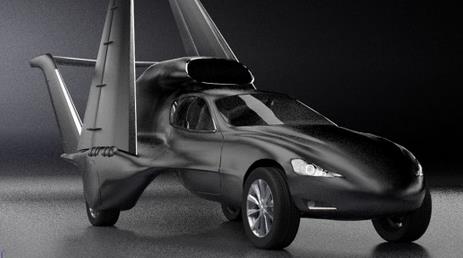
GF7 Car Design Could Legally Hit 550 MPH - In The Sky.
I've been a little disappointed with the 21st century. Internet speeds
are faster and I can do some pretty cool things on my smart phone, but
where are the computerized butlers and flying cars? We may be one step
closer to the flying car fantasy, according to
Gizmag: "
Greg
Brown and Dave Fawcett are working on an design that they hope will
yield something we've spent decades waiting for – a flying jet-propelled
car. A sleek cross between a business jet with a luxury automobile, the
GF7 drives on electric motors while on the ground, then can extend
wings and use a 3,500-lb thrust jet engine to fly to 38,000 ft (12,000
m) and speeds of 550 mph (885 km/h). The (obvious) catch: if this
ambitious project does get of the ground, it won't come cheap..."
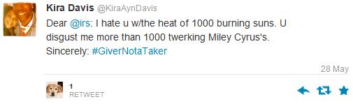
Someone's not getting a refund from the IRS:
TODAY: Warm sunshine, dry. Winds: SE 10-15 Dew point: 60. High: 86
FRIDAY NIGHT: Partly cloudy and humid. Low: 67
SATURDAY: Muggy, PM T-storms likely. Winds: S 15. High: 84
SUNDAY: Front stalls, more T-storms. Dew point: 65. Wake-up: 68. High: 83
MONDAY: Rain & T-storms, locally heavy rain. Wake-up: 67. High: 81
TUESDAY: Showers taper, turning cooler. Wake-up: 64. High: 77
WEDNESDAY: Partly sunny, drying out. Wake-up: 60. High: 78
THURSDAY: Intervals of sticky sun. Wake-up: 59. High: near 80
Climate Stories...
IPCC Co-Chairman Says Scientists Being Intimidated By Climate Change Deniers. The Irish Times has the story - here's the introduction: "
Global
warming deniers have been involved in a “concerted campaign to isolate
individual scientists and destroy them,” according to one of the
co-chairmen of the UN’s Intergovernmental Panel on Climate Change
(IPCC). Prof Thomas Stocker, Swiss-born co-chairman of the panel’s
working group on the scientific basis for climate change, said the
campaign to undermine its fifth assessment report was led by “people and
organisations with vested interests”...
Obama Raises Stakes Against GOP Skeptics. A "creeping national security crisis?"
National Journal has the story - here's a clip: "
President Obama's foreign policy speech
to West Point graduates Wednesday leveled a serious charge against
Republicans who deny human-induced climate change: You're threatening
national security. Check out the progression of the few climate
sentences in Obama's wide-ranging remarks. He starts by telling the
grads that battling global warming requires global cooperation. Then he
says climate change is "a creeping national security crisis that will
help shape your time in uniform, as we're called on to respond to
refugee flows, natural disasters, and conflicts over water and food..."
The Coming Political Explosion Over Climate Change. Here's an excerpt from an analysis at
The Washington Post: "...
This
is also the latest sign climate change could actually become something
of an issue in this year’s campaigns, something environmentalists
have long hoped for. Obviously climate change will not be a central
issue in Senate races. But the topic will probably get more attention
than usual. In part, that’s because more GOP candidates appear to have dabbled in climate skepticism. Among them: Tillis, Terri Land in Michigan, Cory Gardner in Colorado, and Joni Ernst in Iowa..."
Image above: Clean Technica.
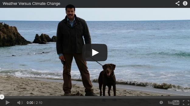
New Video: Neil deGrasse Tyson Destroys Climate Deniers.
If you haven't checked out "Cosmos" yet on National Geographic you
should, especially this upcoming Monday. Here's a link to a video
preview and story from
Mother Jones science writer Chris Mooney: "...
Courtesy of National Geographic, above is a clip from the new episode, which should have climate deniers fulminating. In it, host Neil deGrasse Tyson uses the analogy of walking a dog on the beach to helpfully explain the difference between climate and weather (pay attention, Donald Trump)
and to outline why, no matter how cold you were in January, that's no
argument against global warming. We've seen the rest of the episode
already, and won't spill the beans. But suffice it to say that it
contains some powerful refutations of a number of other global warming
denier talking points, as well as some ingenious sequences that explain
the planetary-scale significance of climate change..."
* "Keep your eye on the man, not the dog". deGrasse's Cosmos
YouTube clip describing the difference between weather and climate is a brilliant.
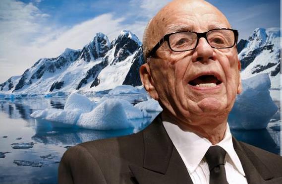
WSJ's Shameful Climate Denial: The Scientific Consensus is not a Myth. Here's an excerpt from
Salon: "
Climate
change is a tricky subject to talk about: It’s a large, complex
scientific issue that’s both difficult to grasp in full and extremely
important for the public to understand. In our shorthand for making
sense of it, one statistic is often thrown about: 97 percent of
scientists agree that man-made climate change is happening. Yet a big,
impressive-looking Op-Ed in the Wall Street Journal
asserts the number is a “myth.” WSJ’s claim is wrong, of course, but
where its authors fail to debunk a popular meme, they also manage to
make a much more insidious, and radical, argument..."
Image credit above: "
Rupert Murdoch." (Credit: Reuters/David Gray/Volodymyr Goinyk via Shutterstock/Salon).
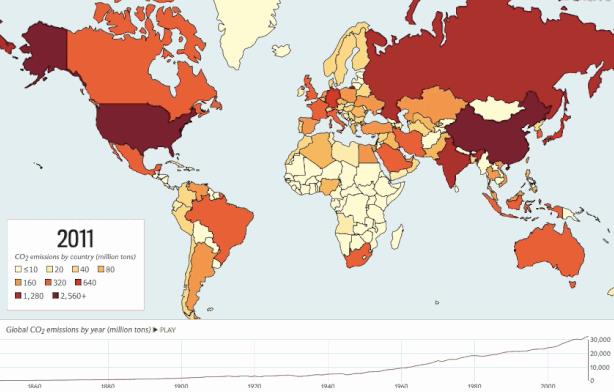
An Animated Map Of The Last 160 Years Of Carbon Emissions Worldwide. Thanks to Slate and
io9.com for making this available; here's a clip: "
Just
how does the carbon dioxide pollution of today compare with that of the
past? Not very well, as this animated map of where and when carbon
emissions have increased across the globe since 1850 reveals. The map is
the work of Slate's Eric Holthaus and Chris Kirk, who used the recent
update to the World Resources Institute's data on carbon emissions to
put it together..."
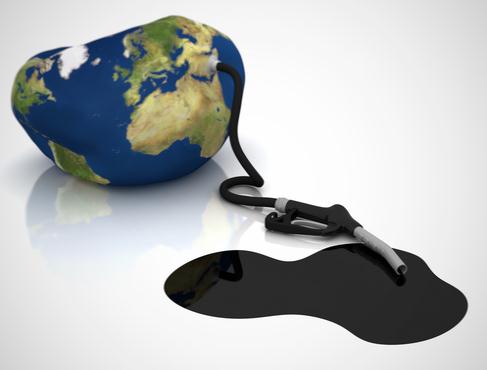
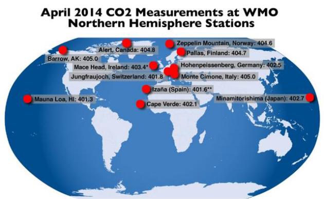
Carbon Dioxide Passes Global 400 ppm Milestone.
Climate Central has an update; here's the introduction: "...
A new carbon dioxide milestone
has been reached according to the World Meteorological Agency. Average
carbon dioxide measurements at all monitoring stations in the northern
hemisphere were above 400 parts per million for the month of April, the
first time that’s been recorded in human history. Previous reports
from the Mauna Loa Observatory, the longest continually running CO2
monitoring site in the world, showed that the average CO2 concentration
for April was above 400 ppm. On Monday, the WMO
reported that the 11 other northern hemisphere monitoring stations that
continuously monitor CO2 also surpassed the 400 ppm mark for the month..."
Graphic credit above: "
The location and April average CO2 levels measured at 12 World Meteorological Organization monitoring stations around the globe." Data: World Meteorological Organization.
Obama To Offer Rules To Sharply Curb Power Plants' Carbon Emissions.
The New York Times has an update; here's the introduction: "
President
Obama will use his executive authority to propose a global warming
regulation that would cut carbon pollution from the nation’s coal-fired
power plants by up to 20 percent and pave the way for the creation of
state cap-and-trade programs without having to go through a reluctant
Congress, according to people familiar with the rule. The proposed
regulation, written by the Environmental Protection Agency and set to be
unveiled Monday by Mr. Obama at the White House, would be the strongest
action ever taken by an American president to tackle climate change and
could become one of the defining elements of Mr. Obama’s legacy..."

Climate Change a Top Priority, Says ExxonMobil CEO.
I had to pick myself up off the floor after reading this one. The CEO
of ExxonMobile acknowledging man-made climate change? I want to give
anyone the benefit of a doubt, and the ability to change their mind
based on data and facts on the ground. Will technological innovation
save us from ourselves? Here's an excerpt from Natural Gas Intelligence: "...He
(ExxonMobile CEO Rex Tillerson) asked shareholders to "rightfully
acknowledge" that climate change "is the most complex area of scientific
and social conversation anyone's having today. It is extremely complex.
And it is one that's not going to be a ready set of solutions that are
going to fit the world's peoples because the world's peoples all have
varying needs in this stage of their development, which is why it makes
it so complex. "We do support and engage in, and will continue to engage
in, active dialogue." Among other things, ExxonMobil scientists have
continued to be actively engaged with the United Nations'
Intergovernmental Panel on Climate Change, said Tillerson..."
Beetles and Climate Change Helped Create This Huge Wildfire in Alaska. Meteorologist Eric Holthaus explains at Slate; here's a clip: "...This
particular fire has grown so large as a result of “years of spruce bark
beetle infestation,” he told me. The bugs have killed and weakened
countless trees in this area, creating more kindling. That’s forced fire
command agencies to take a step back and essentially let the fire burn,
for safety reasons: “You can’t put people into an area where a bunch of
trees have died and fallen.” The U.S. Forest Service predicts
that “the greatest risk to spruce forests over the next 30 years will
be in Alaska,” as spruce beetles expand their attack on trees..."
File photo above: "
Trees
turning red in forests that have been attacked by the mountain pine
beetles in Montana, July 7, 2011. Some scientists are increasingly
worried that as the warming accelerates, trees themselves could become
climate change victims on a massive scale." (Josh Haner/The New York Times).
Government's Weather Forecasters Shouldn't Discuss Climate Change, Says Environment Canada. Here's an excerpt of an interesting post from
Mike De Souza: "
Weather
forecasters at Environment Canada aren’t supposed to discuss climate
change in public, says a Canadian government spokesman. Environment
Canada made the comments in response to emailed questions about its
communications policy. The department defended its policy by suggesting
that Environment Canada meteorologists – among the most widely-quoted
group of government experts in media reports and broadcasts – weren’t
qualified to answer questions about climate change. “Environment Canada
scientists speak to their area of expertise,” said spokesman Mark
Johnson in an email..."


No comments:
Post a Comment