59 F. high in the Twin Cities Wednesday.
69 F. average high on May 14.
98 F. high on May 14, 2013. No, that's not a typo. It really got that hot.
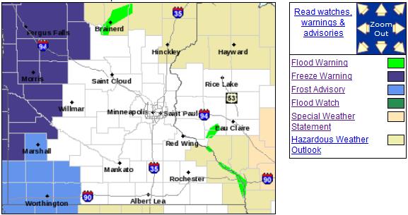
Freeze Warning far western Minnesota this morning.
.02" rain from PM showers later today.
"May-tober"
I'm
more confused than usual. Not sure whether to mulch the garden, toss a
football, or go Trick-or-Treating? Big decisions. THIS is why smart
gardeners wait until after Memorial Day, not Mother's Day, to plant
annuals.
After studying the weather map I'm not sure whether to
laugh or weep. A high-amplitude jet stream pattern (big dips and bulges
in the prevailing winds aloft) is creating mind-boggling extremes. Brush
fires are raging across drought-baked counties in the Texas Panhandle,
where Freeze Warnings are in effect. At the same time record heat
sizzles southern California and skiers hit the slopes one last time in
Colorado & Wyoming.
Once again weather systems have stalled, a
Great Lakes low pinwheeling clouds and light showers into Minnesota by
afternoon. Another pop-up shower may sprout late Friday.
Spring stages a valiant comeback over the weekend; highs topping 70F by Sunday with blue sky and a hopeful, southerly breeze.
A
stalled warm front sparks T-storms much of next week; a warm, sticky
and partly-thundery weather pattern lingers Memorial Day weekend, with
highs closer to average.
All well and good. But tonight? Cover up those tender shoots, just in case.
A Refreshing May Freeze.
Freeze warnings are posted for western Minnesota this morning, the
combination of clear skies,light winds, and a (dry) Canadian airmass
allowing temperatures to drop into the low 30s again. Yes, I'm enjoying
"spring".
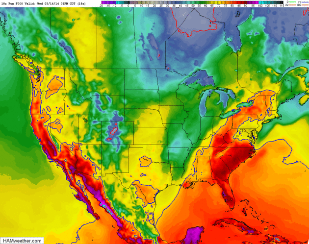
Stuck In A Chilly Rut.
Once again weather systems are in a holding pattern - a bit odd for
May; "cut-off" lows are more likely in March or October. A swirling
pocket of unusually cold air aloft will spark snow over the U.P. of
Michigan, pumping unusually cool air southward to Texas and Arkansas.
While the east warms up with heavy showers and T-storms and the western
USA sizzles. NAM 2 meter temperatures courtesy of NOAA and HAMweather.
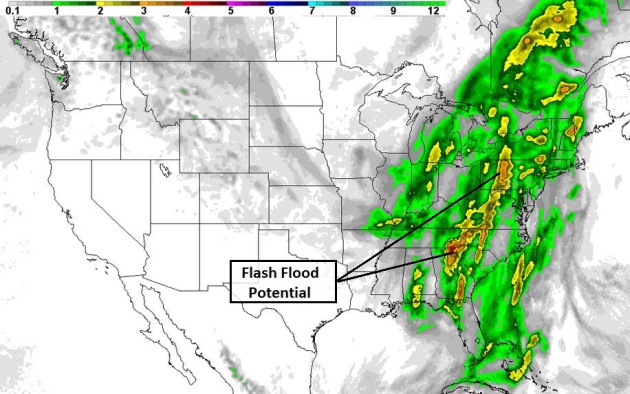
East Coast Soakers.
A very slow moving frontal passage will spark some 2-4" rainfall
amounts along the Appalachians, from Pittsburgh to Atlanta, sparking
spotty flash flooding problems. Meanwhile the rest of the USA stays dry
into Saturday night.
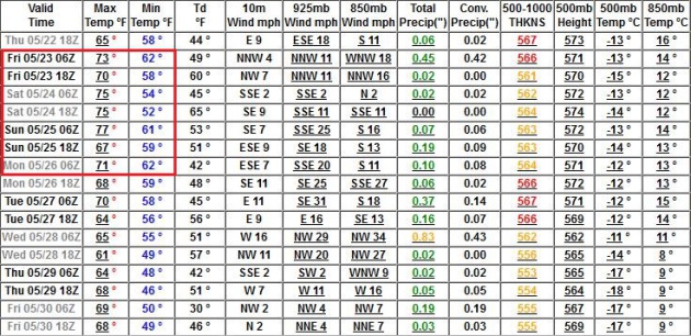
A Lukewarm Memorial Day Weekend?
At some point, at least in theory, we will climb out of this chilly
pattern and emerge into something vaguely resembling spring, or maybe
leapfrog into summer. GFS guidance shows 70s on Memorial Day weekend in
the MSP metro. I'm not celebrating just yet, but I find the data
encouraging. Place your bets.
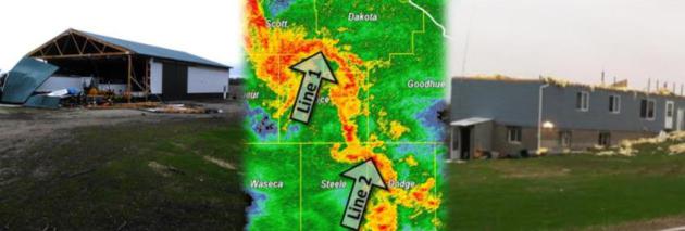
Preliminary Data on May 8 Outbreak.
At least 2 tornadoes touched down over southwestern Minnesota last
Thursday, but straight-line wind damage produced even more damage near
Waseca, Montgomery and Red Wing, according to the
Twin Cities office of the National Weather Service.
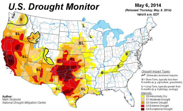
Partially Parched: Half of U.S. Is In Drought.
Yahoo News has an update on extreme to exceptional drought, now spreading into the southern and central Plains; here's an excerpt: "...
The drought
is deepest in California and the Texas and Oklahoma panhandles,
according to the latest drought map, released May 8. Most of California
is in extreme or exceptional drought, and triple-digit heat was
returning to Texas and Oklahoma, according to Mark Svoboda of the
National Drought Mitigation Center, who penned a report on recent
drought conditions. "This is not the recipe for recovery as the calendar
pushes toward summer," Svoboda wrote of the heat in the Texas and
Oklahoma panhandles. "What winter wheat wasn't damaged or killed off by
recent hard freezes was left to bear the brunt of the heat and dryness
this week, with little in the way of relief on the horizon..." (Map above:
U.S. Drought Monitor).
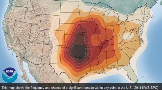
Texoma's EF2-EF5 Tornado Risk Highest In Nation. I found this interesting; where (statistically) the most intense tornadoes touch down, courtesy of
texomashomepage.com: "
The National Weather Service keeps a continuous record of the following statistics:
- Tornadoes that occur in the nation
- Strength of the tornadoes
- Frequency of the tornadoes in a geographic area
- Damage of the tornadoes
This
information combined allows the National Weather Service Storm
Prediction Center (NWS-SPC) to create risk maps for significant
tornadoes. These maps are updated daily but a clear trend has been
evident lately..."
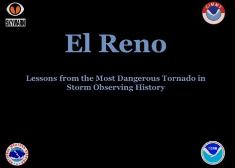
New Video Gives Great Tornado Safety Information.
KRMG
in Tulsa has a link to a remarkable video with timely information
learned in the wake of 2013's epic tornadoes across Oklahoma: "
May
of last year was a dangerous and deadly month for storms around Oklahoma
City. 24 people killed in Moore on May 20, 2013 and 8 killed in El Reno
on May 31, 2013, some of them highly-trained storm chasers. A new video
aims to keep people safe."
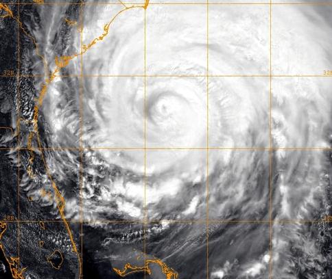
Hurricane Hiatus: Will The USA's Luck Run Out This Year?
With a brewing El Nino and more (predicted) wind shear over the tropics
the trend once again this year should be fewer tropical storms and
hurricanes. Then again, it only takes one. Here's an excerpt from
USA Today: "
Will
this be the year the USA's luck runs out? With the Atlantic hurricane
season starting June 1, the nation is enjoying two record streaks for a
lack of hurricanes: It's been nine years since the last hit from a
"major" hurricane and also nine years since a hurricane of any sort hit
Florida, traditionally the most hurricane-prone state in the nation.
Both streaks began on Oct. 24, 2005, when Category 3 Hurricane Wilma
slammed into southwest Florida with 120-mph winds..."
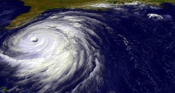
Tropical Cyclone "Maximum Intensity" Is Shifting Toward Poles. Here's a clip of new research findings from
NOAA NCDC: "
Over
the past 30 years, the location where tropical cyclones reach maximum
intensity has been shifting toward the poles in both the northern and
southern hemispheres at a rate of about 35 miles, or one-half a degree
of latitude, per decade according to a new study, “The Poleward
Migration of the Location of Tropical Cyclone Maximum Intensity,”
published tomorrow in Nature. As tropical cyclones move into higher
latitudes, some regions closer to the equator may experience reduced
risk, while coastal populations and infrastructure poleward of the
tropics may experience increased risk. With their devastating winds and
flooding, tropical cyclones can especially endanger coastal cities not
adequately prepared for them. Additionally, regions in the tropics that
depend on cyclones’ rainfall to help replenish water resources may be at
risk for lower water availability as the storms migrate away from them..."
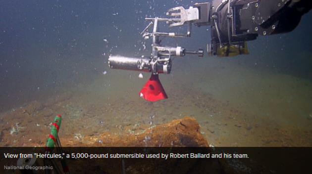
Could Dangerous Underwater Volcano In Caribbean Cause a U.S. Tsunami? The idea may not be as far-fetched as it sounds, according to a story at
ABC News; here's an excerpt: "...
Ballard,
the president of The Ocean Exploration Trust and the director of the
Center for Ocean Exploration at the University of Rhode Island’s
Graduate School of Oceanography, said the Kick'em Jenny volcano has a
history of explosive eruptions, which could have the potential to
trigger tsunamis, the effects from which could be felt as far away as
the northeastern United States. According to the U.S. Geological Survey
(USGS), the Kick'em Jenny volcano has erupted 10 times since 1939 with
the most recent eruption in 1990..."
Image above: National Geographic.
The 10 Greenest Mid-Size Cities. Did your town make the cut? Here's an excerpt from a story at
mylife.com: "
It
takes a little effort being “green.” From separating recycling and
trash, to taking public transportation, to walking to the grocery store
instead of driving, it takes a lot of energy to consume less energy. But
these ten cities proved that it is worth the extra time to go above and
beyond the normal environmental concerns..."
Apple Said To Be Planning Split-Screen iPad Multitasking In IOS 8. Sounds cool, but I'm hoping for quad-screen multi-processing to tame my raging case of digital ADHD. Here's an excerpt from
Tech Crunch: "
A
new report from 9to5Mac’s Mark Gurman, who has a strong track record in
predicting the future of Apple’s software, says that Apple will be building split-screen multitasking into iOS 8,
the next major update for its mobile devices. This split-screen
functionality will resemble these features as seen in recent Samsung
tablets and the Microsoft Surface, the report claims. This comes hot on
the heels of a new jailbreak tweak that adds almost exactly that kind of
multitasking to iPad called “OS Experience.“...
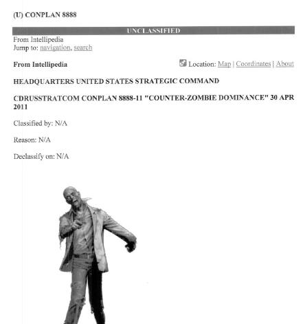
The Military Has A Plan To Stop The Zombie Apocalypse. Seriously.
Foreign Policy
has the details, and yes, it's for planning purposes only - I don't
think the Pentagon is really concerned about zombies. Yet. Here's a
clip: "...
Incredibly, the Defense Department has a response if
zombies attacked and the armed forces had to eradicate flesh-eating
walkers in order to "preserve the sanctity of human life" among all the
"non-zombie humans." Buried on the military's secret computer network is
an unclassified document, obtained by Foreign Policy,
called "CONOP 8888." It's a zombie survival plan, a how-to guide for
military planners trying to isolate the threat from a menu of the undead
-- from chicken zombies to vegetarian zombies and even "evil magic
zombies" -- and destroy them..."
TODAY: Early sun, then clouds, PM showers. Winds: N 10. High: 52
THURSDAY NIGHT: Slow clearing, still chilly. Low: 37
FRIDAY: Clouds increase, stray shower late. High: 54
SATURDAY: More clouds than sun, better. Wake-up: 38. High: 60
SUNDAY: Partly sunny. Feels like May again. Wake-up: 42. High: 71
MONDAY: Showers, heavier T-storms. Wake-up: 51. High: 72
TUESDAY: Humid, stray T-storm or two. Wake-up: 58. High: 75
WEDNESDAY: Unsettled, more T-storms. Wake-up: 55. High: 73
Climate Stories...
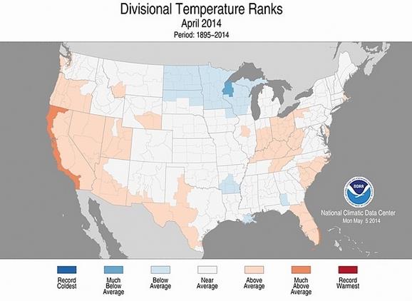
April Was Second Warmest Globally, Average for USA.
Climate Central has the details - here's the introduction: "
While
April was an uneventful month temperature-wise in the U.S., with most
areas experiencing near-average temperatures, the month was the
second-warmest April on record globally, according to new NASA data.
That makes April the 350th month in a row — more than 29 years — with
above-average temperatures, largely caused by the buildup of manmade
greenhouse gases in Earth’s atmosphere..." (Image: NOAA NCDC).
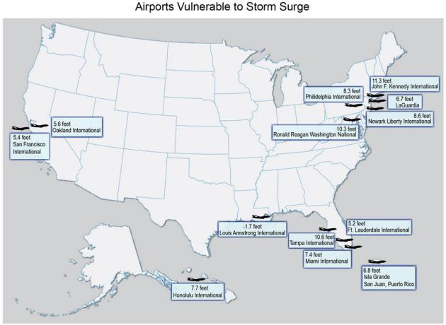
From Airports to Interstates: Global Warming Threatens Coasts.
Here's an excerpt from a story focusing on transportation
infrastructure at increasing risk of rising seas and storm surges,
courtesy of
U.S. News: "...
More
than a dozen of the nation's 47 largest airports, meanwhile, have at
least one runway that sits within reach of moderate to high storm surge.
In fact, all three major airports around New York City – Newark,
LaGuardia and JFK – are all at risk, as are Philadelphia International
and Ronald Reagan Washington National..." (Graphic above: U.S. News).
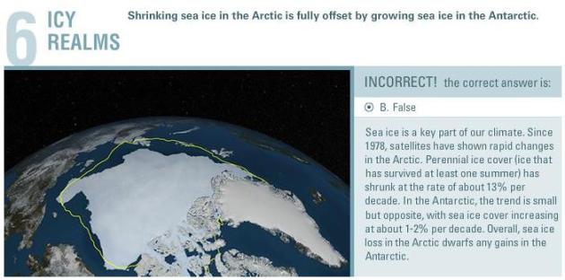
Shrinking Arctic Sea Ice Is Fully Offset By Growing Antarctic Sea Ice? False. So says NASA, which provided the graphic above.
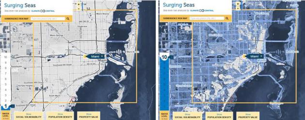
What Does U.S. Look Like With 10 Feet Of Sea Level Rise?
Granted, this won't happen next year, or even 20 years from now, but
some of the models are suggesting as much as 4-6 feet of rise by the end
of this century, depending on the rate of melting in Greenland and West
Antarctica. The honest answer is we don't really know how fast water
levels will rise. Here's a clip from an interactive tool at
Climate Central: "
New research indicates that climate change has already triggered an unstoppable decay
of the West Antarctic Ice Sheet. The projected decay will lead to at
least 4 feet of accelerating global sea level rise within the next
two-plus centuries, and at least 10 feet of rise in the end. What does
the U.S. look like with an ocean that is 10 feet higher? The radically
transformed map would lose 28,800 square miles of land, home today to
12.3 million people..."
U.S. Military Pressed on Climate Change.
The Pentagon is taking climate change seriously as a force-multiplier, a
potential catalyst capable of igniting local and regional conflicts
related to mass migrations linked to shortages of water and food - as
well as rapidly melting Arctic ice during the summer months and
potential skirmishes as countries jockey for mineral rights at the top
of the world. Here's a clip from
The Wall Street Journal: "
The
military panel that advises CNA also found that many changes were
happening more quickly than they predicted in 2007 in their latest
report that examined the national-security implications of climate
change. "For our national defense, we need to be making sure we are more
resilient for the changes we have locked in," said retired Adm. David
Titley, the former oceanographer of the Navy. "It is changing the battle
space the Department of Defense operates in..." (File photo: Hassan Ammar, AP).
Center For Naval Analyses Military Advisory Board: Climate Change Is Severe National Security Risk. Details from
Daily Kos.
The Forgotten History of Climate-Change Science. No, this is not a new "discovery" or untested theory, as described in this article from
NPR; here's an excerpt: "...
So
through Fourier and Tyndall we could trace the basic elements of the
greenhouse effect back almost 200 years. Hardly the stuff of a modern
conspiracy. But neither of these researchers suggested that human beings
were doing anything to alter the chemistry of the atmosphere. Surely
that is a recent invention of the environmentalist age. The first
calculation of the greenhouse effect to include human-driven release of
greenhouse gases came about 100 years ago. Using estimates of coal
burning, Swedish chemist built on other calculations he'd made and
estimated that doubling the CO2 content of the planet's atmosphere would
raise it's temperature by 2.5 to 4.0 degrees Celsius. That is where it
all begins...."
Delays on Climate Change Have Cost Us $8 Trillion.
NewScientist has the study and details; here's a clip: "
TIME is money, goes the saying. When it comes to climate change, two years of inaction has cost the world $8 trillion. A report
from the International Energy Agency (IEA), published Monday, looks at
the cost of converting to green electricity in order to keep global
warming below 2 °C. The agency found that it will cost $44 trillion more
than keeping the current mix, where most electricity comes from fossil
fuels. The extra money will go on building wind and solar power
stations, efficient grids, electric vehicles and infrastructure..."
Climate Change: Has Science Finally Won The Debate? Here's an excerpt from a story at
The Guardian: "...
Consensus
on climate change built incrementally through the 1990s until, by the
time the 2001 IPCC report came out (with the hockey stick graph in it),
there were very few scientists who felt uncomfortable attributing some
climate change to human activity. But Hulme says there was no collective
eureka moment and there will always be doubt and questions. "Science
doesn't really do that. It is always an unending process of
confirmation, correction, refutation … It is the collective social
practice of science that in the end gives science its particular
credibility and status. But it's a rather harder thing to get to the
bottom of because you can't just focus on one charismatic individual..."


No comments:
Post a Comment