486 billion bathtubs
By Paul Douglas
By Paul Douglas
"People run from rain but sit in bathtubs full of water." wrote Charles Bukowski in The Roominghouse Madrigals. I've been running a lot this year, trying to get away from people who are convinced I have something to do with our weather, which has been described as cruel, cursed - or worse.
A bathtub is a good way to put last week's historic rains into perspective. From June 15-21 the southern third of Minnesota picked up at least 4 inches of rain (some spots saw 6-10") but let's go with the low number for now, as an average.
4 inches of rain falling on 28,000 square miles translates into 1.9 trillion gallons, or 486 BILLION bathtubs full of water, according to the USGS. No wonder we're under siege.
An instability T-shower may still sprout Tuesday afternoon, but from today through Wednesday the sky over your house or farm should be mostly-dry. A few days to recover with highs in the upper 70s and dew points dipping into the 50s. More tolerable.
Next weekend highs may nudge 90 degrees for the first time this "summer". The arrival of this steamy, drippy airmass will spark - wait for it - tropical T-storms Thursday into the weekend.
More unwelcome bathtubs full of water.
===============
SUNDAY NIGHT: Lingering T-storm possible, otherwise mostly cloudy. Low: 65
MONDAY: Unsettled, stray shower or T-shower - but not as wet. High: 82. Winds: SSW 5
MONDAY NIGHT: Mostly cloudy and dry. Low: 62.
TUESDAY: Sunny start, few PM showers? High: 79
WEDNESDAY: Some sun, nighttime T-storms. Wake-up: 58. High: 77
THURSDAY: Warm & sticky; spotty T-storms. Wake-up: 62. High: 77
FRIDAY: Hot sun, late-day pop-up storm. Wake-up: 64. High: 82
SATURDAY: Sweaty sunshine, lake-worthy. Dew point: 70. Wake-up: 67. High: 86.
SUNDAY: Summer heat returns. Late day thundershower possible. Wake-up: 70. High: Near 90.
==================
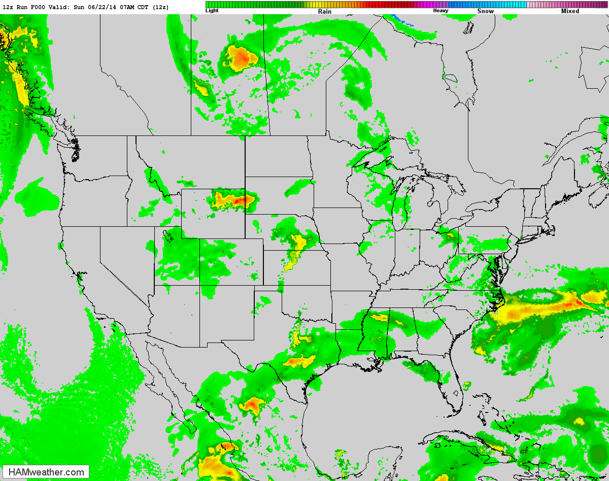
Future Radar
The weather outlook from AM Sunday through Wednesday evening shows the heaviest rain potential moving through during the later half of the weekend. However, unsettled weather looks to persist through much of the weekend ahead.
==========================
This Day in Weather History
June 23rd
June 23rd
2002: Just a few weeks after torrential rains hit the area, another round of heavy rain hit northern Minnesota. This time up to eight inches fell in a two-day period in small parts of Mahnomen and St. Louis Counties.
1992: Chilly air across Minnesota with a high of 48 at the Duluth Harbor and 52 at Grand Marais.
==================
Average High/Low for Minneapolis
June 23rd
June 23rd
Average High: 81F
Average Low: 71F
==================
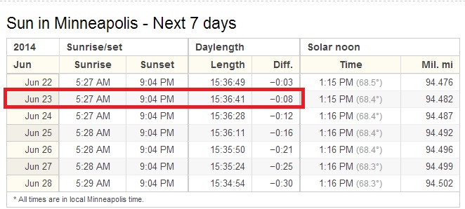
Sunrise/Sunset Times
June 23rd
June 23rd
Sunrise: 5:27 AM
Sunset: 9:04 PM
Sunset: 9:04 PM
The Summer Solstice occurred on Saturday, June 21st at 5:51 AM CDT. That was the longest day of the year for us in the northern hemisphere and if you can believe it, the days are actually getting shorter! It's not much just after the solstice, but we are indeed losing light... SIGH!
=========================
Moon Phase for June 23rd at Midnight
3.0 Days Before New Moon
3.0 Days Before New Moon

============================
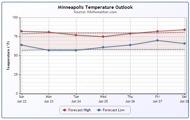
Minneapolis Temp Trend
According to some extended weather models, temperatures close to home look to remain fairly status quo. At this point, it doesn't appears that any big temperature fluctuations are in the works. Warm and sometimes muggy; just as summer should be and yes, there will be plenty of mosquitoes!
Precipitation Update for Minneapolis
No doubt it has been a WET June so far! Take a look at these crazy precipitation stats from the Minneapolis/St. Paul International Airport. Through June 21st, there had been 10.76" of rain, which is 7.82" above normal for the month. 25.23" of precipitation (rain & snow) had fallen for the year so far, which is 12.71" above normal!
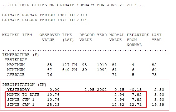
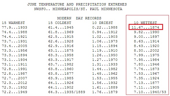
Wettest June in History
Through June 21st, the KMSP Airport had seen 10.76" or rain, which has made it the 2ND WETTEST June in recorded history. The wettest June on record is 11.67" set in 1874! It is very possible that we see this record broken by the end of the month!
Rainfall Past 14 Days
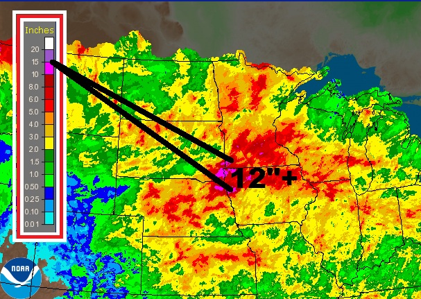
According to NWS radar estimated rainfall, there have been a number of locations across the Midwest that have seen 5" or rain or more (red contouring) over the past 2 weeks! In fact, there have been a number of locations that have seen nearly 10" to 12" or more! No surprise that flooding has been such a big concerns this month!
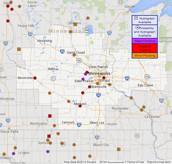
River Flooding Continues
As of Sunday, the National Weather Service was indicating that there were 40 gauges in flood stage in the map view below. 15 of those were either moderate to major flooding!
Major Flooding Expected along Mississippi River
Take a look at the Mississippi River gauge at St. Paul, the forecast is for it to be in Major Flood Stage from Sunday through next weekend! At this point, the forecast crest will occur around 20ft on Thursday, which will be nearly 6ft. below the record crest on April 16th, 1965.
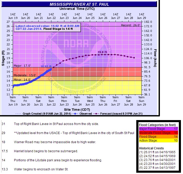
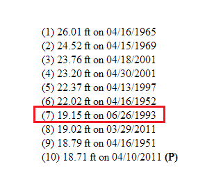
Top 10 Crests Expected at Mississippi River in St. Paul!
According to latest NWS river forecasts, the Mississippi River in St. Paul is expected to see a top 10 crest by Thursday, June 26th at near 20ft! Interestingly, the crest will coincide with the 7th highest crest at that gauge set on June 26th, 1993 at 19.15 ft. Also note that Summer river crests aren't as common as Spring river crests! Due to a combination of factors (snow, snow pack, temperatures, rain) the spring often sees a lot more (widespread) water entering watersheds at a more rapid pace than you would see in the Summer. It just goes to show you how 'rare' this type of heavy daily rainfall can be.
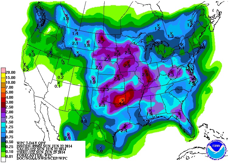
More Rain on the Way
According to NOAA's HPC, the 7 day rainfall forecast (June 22nd - June 29th) suggests that we could see an additional 1" to 2" or more of rain across parts of the Midwest by the end of the month. Keep in mind that longer term 'convective' rainfall can be a bit more complex to forecast and perhaps not quite as accurate; however, as of June 21st, the KMSP Airport only needed 0.91" of additional rain to tie the wettest June on record of 11.67" set in 1874!
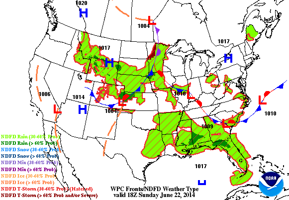
Unsettled Weather Continues
Nationally speaking, the active weather continues through the early week as our fairly weak storm system slides east. Pockets of heavy rain and isolated severe storms can't be ruled out as the storm system shifts into the Eastern U.S. by midweek.
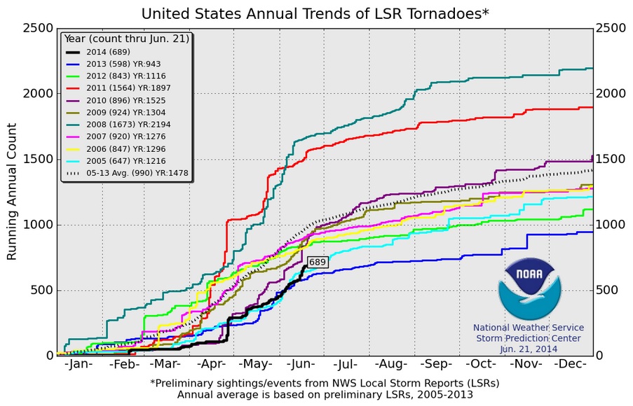
2014 U.S. Tornado Count
June 2014 has been comprised of fairly slow moving weather systems, in which stalled frontal boundaries have been igniting daily thunderstorms with heavy rain and severe weather. The 2014 count has been bumped up quite significantly over the past few weeks and according to NOAA's SPC, the 2014 U.S. PRELIMINARY tornado count through June 21st is now at 689. Interestingly, we are still below the 2005-2013 short-term average of 990 through June 21st.
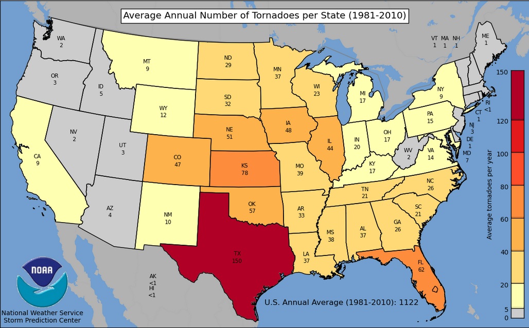
Average Annual Tornadoes by State
According to NOAA's SPC, the average annual tornadoes across the U.S. (From 1981-2010) is nearly 1,122. The 30-year average for Minnesota is 37 tornadoes/year.
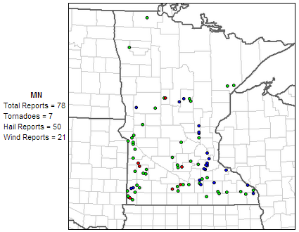
Minnesota Storm Reports
According to NOAA's SPC, there have been 78 PRELIMINARY severe storm reports across the state this year, 7 of which have been tornado reports. Keep in mind that June is typically our busiest month of the year for tornadoes; according to NOAA's NCDC, Minnesota averages 18 tornadoes in June (average 1991-2010). So far this year, the PRELIMINARY count for Minnesota in June is 2.
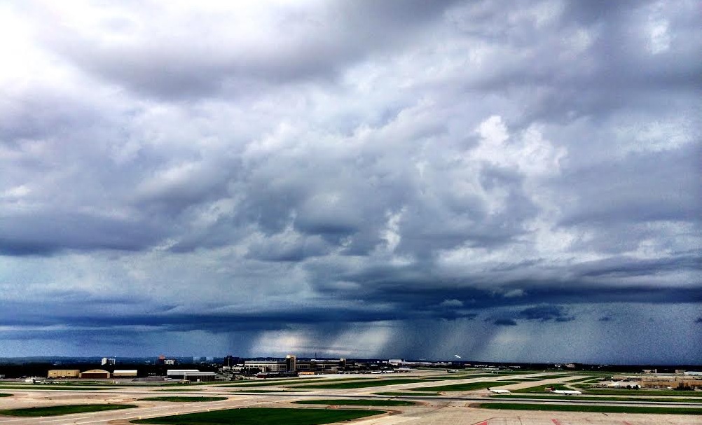
Unsettled Sunday
A line of thunderstorms and a quick burst of rain (0.09" officially just before 12pm at the KMSP airport) caused a few minor delays at area ballparks and soccer fields across the metro. The good news is that it didn't last long, but it was a bit soggy afterwards, especially for those beautiful cars at the MN State Fairgrounds for the 41st Annual Back to the Fifties.
Back to the Fifties
Did you get out to Back to the Fifties this year? It was a little warm on Saturday, but in all honesty, we couldn't have asked for better weather!


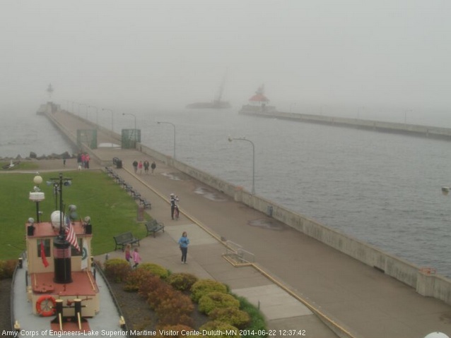
Cool and Foggy Weekend in Duluth MN
This weekend was also Grandma's Marathon Weekend on Duluth, MN... Possibly one of my favorite weekends out of the entire year. I couldn't make the trip up north for the fun-filled weekend, but hopefully next year. Weather at this time of the year can be quite interesting next to the coldest and the deepest of the Great lakes. Lake Superior and downtown Duluth have a strange relationship during the first half of the 'warmer' months. Mid June weather in Duluth can range from cold and foggy to tropical. This year's weather was perfect for runners, but for spectators it was not necessarily ideal. By the way, congrats to Dominic Ondoro for setting the new course record of 2:09:05 !! UNREAL!! The previous course record had been held by Dick Beardsley for nearly 30 years!
"It’s been 30 years since the Grandma’s Marathon course record was broken. Dick Beardsley’s 2 hours, 9 minutes and 37 seconds performance in 1981 has stood the test of time; with many eager runners trying to break it. Beardsley recently recalled all the wonderful memories and emotions he felt that day, and in the years to follow, in the following correspondence with him.
It is hard to believe that the record has stood for 30 years, the record and the race mean the world to me. Someone just last month wrote me and said it is the longest standing record for a major marathon."

Take a look at what downtown Canal Park looked like midday Sunday... Still socked in with fog and temperatures in the 40s!! If you look close, you can actually see people in long pants and COATS!! Duluth truly is "Cooler by the Lake" !
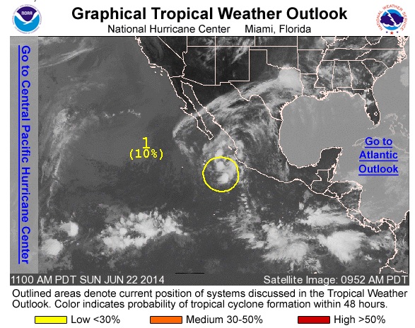
Tropical Update
The 2014 Atlantic Hurricane Season started June 1st and it has been rather quiet, however, the Pacific Hurricane season, which started May 15th has been quite impressive so far. We have had 3 named storms, 2 of which have become Category 4 Hurricanes Amanda and Cristina!! The National Hurricane Center is keeping an eye on a weak wave off the shore of Mexico.
Thanks for checking in and have a great week ahead! Don't forget to follow me on Twitter @TNelsonWNTV

No comments:
Post a Comment