81 F. high in the Twin Cities Monday.
83 F. average high on June 30.
82 F. high on June 30, 2013.
11.36" rain fell in June; wettest since 1874 (when 11.67" fell).
60s today, nearly 20F. cooler than average.
First World Problems
"Paul,
will there be a T-storm for my 4th of July fireworks show? Will I be
able to get a 'safe tan' (oxymoron) next weekend, is there still a
no-wake zone on my favorite lake?"
Most people around the world
would love to have such worries. Many of them will be too busy finding
drinkable water or tracking down their next meal.
No sermons (I'm
not licensed) but the 4th of July holiday reminds us what's really
important over the long haul: time with friends & family. Weather
should be an afterthought.
For the record a few T-storms may
bubble up from late Friday into Monday, but no sustained
all-weekend-washouts are brewing. Expect 70s on the 4th, 80s Saturday
with an outside shot at 90F Sunday; the best chance of storms during the
overnight hours.
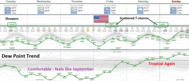
The wettest June since 1874 gives way to a
Canadian breeze into midweek. Showery rains and 60s today (more like
October 1) give rise to a clearing trend tomorrow, followed by a
spectacular, sun-drenched Thursday. Start your holiday early.
Our
4th of July weather headaches pale compared to the Outer Banks of North
Carolina. Odds favor the formation of "Arthur", which may strike as a
Category 1 hurricane on Friday. Details below.
Canadian Breeze - Summer Rerun 4th of July Weekend.
Unstable air sparks clouds and numerous showers today (too cool for
anything severe - but thunder/lightning and even small hail can't be
ruled out with a few of these cells). Dew points drop into the 40s
Wednesday and Thursday, more like September before the next surge of
warm, sticky air sparks a few scattered storms Friday into Monday.
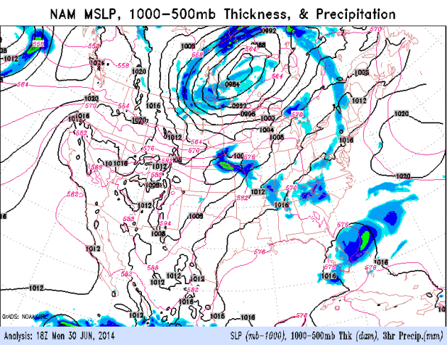
Tracking "Arthur" - Canadian Air Sweeps South.
The 84 hour NAM from NOAA shows heavy showers and T-storms pushing
across the Great Lakes into New England followed by clearing and a big
drop in humidity. You can see the swirl of moisture off the east coast
of Florida tracking up the Carolina coast by Friday.
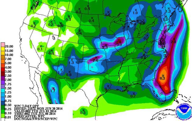
7-Day Rainfall.
The Dakotas and Minnesota get a break from monsoon rains in the coming
days; heaviest rains expected from near Des Moines to Chicago. A
tropical system pushing up the east coast is expected to drop heaviest
rainfall amounts over the Atlantic Ocean, but coastal communities may
see some 3-5"+ amounts from near Savannah and Charleston to the Outer
Banks and Norfolk by the weekend.
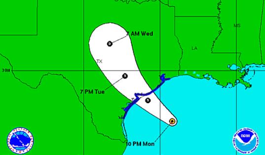
Alerts Broadcaster Briefing: Issued Monday evening, June 30, 2014.
* Tropical depression off the east coast of Florida already producing 30-35 mph sustained winds.
*
Conditions are ripe for strengthening to Tropical Storm force
("Arthur") within 24-48 hours; moderate flooding and storm surge rises
are likely from Daytona Beach, Florida northward to Jacksonville,
Savannah, Hilton Head and Charleston, South Carolina.
* Storm will
probably strengthen to Category 1 hurricane strength as it pushes
across the Outer Banks of North Carolina on Friday, July 4.
* No tropical storm/hurricane watches have been issued (yet), but
I expect NOAA NHC to place most of the Southeast USA coast under a Tropical Storm or Hurricane Watch within 24-36 hours.
At the rate we're going I would expect evacuation orders to be given
for barrier islands by midweek, including portions of the Outer Banks.
Mitigating factors: with the holidays imminent coastal populations are
much higher than average -
it will take even much more time than normal to safely evacuate the most vulnerable barrier islands.
*
"Arthur" still expected to veer out to sea, brushing Virginia Tidewater
with heavy rain capable of flash flooding and a 2-3 foot storm surge.
Some lowland flooding and minor beach erosion can't be ruled out farther
north from coastal New Jersey and Long Island to Cape Cod, especially
at astronomical high tide Friday and Saturday.
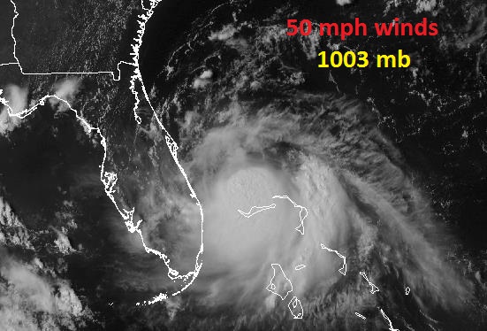
Tropical Swirl.
NOAA NHC is now saying there's an 80% probability that the tropical
depression east of Florida will strengthen into a tropical storm within
48 hours. Image: WeatherTap.
Track Ensemble.
NOAA's HWRF model (probably the most accurate U.S. model over time)
agrees with ECMWF (European) solutions - showing a probably track
hugging the East Coast. A portion of the storm's circulation will be
over land, but this may be offset by unusually warm Gulf Stream water
providing additional heat and fuel to the system, causing additional
intensification as it tracks up the coast, much like a winter
Nor'easter. Source: NOAA.
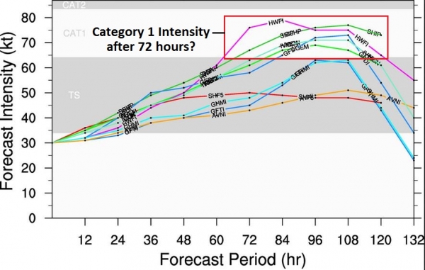
Models Trending Stronger.
Although this is no Sandy (or Katrina), "Arthur" stands an increasingly
good chance of becoming a Category 1 hurricane, with sustained winds of
75-85 mph winds. Again the larger concern is not wind speed, but how
winds and pressure combine to create a storm surge, the dome of water
pushed ashore ahead of the "eye", and whether the surge will coincide
with local high tide, which would compound flooding problems, especially
for the Outer Banks of North Carolina. A majority of NOAA models now
strengthen this system into a hurricane after 72 hours. Source: NOAA.
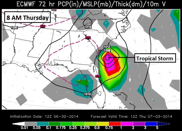
8 AM Thursday: Probably Tropical Storm East of Savannah.
ECMWF guidance shows sufficient intensification for tropical storm
status by Wednesday or Thursday, the storm capable of minor to moderate
storm surfe flooding, but as long as the center of low pressure remains
just offshore any flooding won't be as bad as if the storm tracks
ashore. Note the relatively small size of the storm, which may help to
reduce any subsequent storm surge. Map source: WSI.
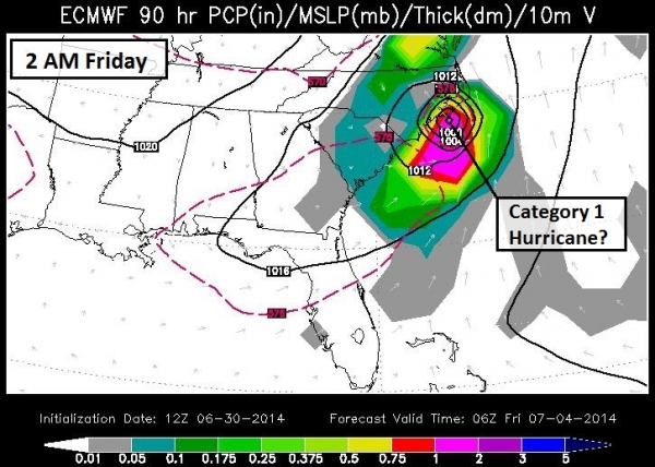
2 AM Friday: Probable Hurricane Pushing into eastern North Carolina.
ECMWF guidance shows the center of the storm near Wilmington, North
Carolina during the wee hours of the morning Friday, producing a
significant storm surge for the Outer Banks. I suspect the heaviest
rains, strongest winds and worst coastal storm surge flooding for North
Carolina will be morning and midday hours on Friday. Map: WSI.
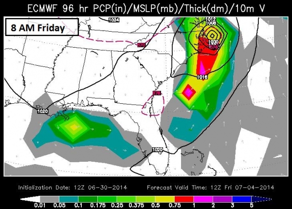
8 AM Friday: Category 1 Hurricane East of Duck/Corolla, North Carolina.
There is some evidence that "Arthur" may accelerate as it passes over
the Outer Banks, which will limit the time over land and possibly reduce
overall rainfall amounts (there is no evidence this system will stall,
which would pose an even greater risk of inland flooding). The worst
flooding from Cape Hateras to Duck, Virginia Beach, Newport News and
Norfolk will come Friday morning; a surge of 2-4 feet is possible, with
locally higher levels of water pushed ashore. Map: WSI.
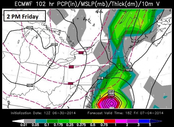
2 PM Friday: Possible Hurricane East of Ocean City, Maryland.
Right now I don't envision a "Sandy-scenario" where upper level winds
cause the storm to hook inland. All the model solutions show the storm
accelerating out to sea, including the ECMWF (European) - which did a
very admirable job tracking Sandy. The latest ECMWF solution shows a
possible Category 1 hurricane just east of the Delmarva Peninsula midday
Friday, capable of significant storm surge flooding from Bethany Beach
to Ocean City, Cape May and Wildwood, NJ, with large swells pushing into
the southern shoreline of Long Island. Map: WSI.
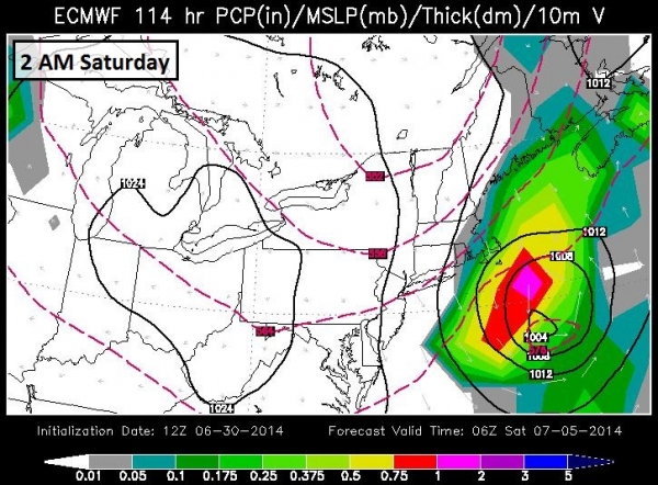
2 AM Saturday: Storm Weakens Slightly - Accelerates Out To Sea.
Although Long Island and Cape Cod may be brushed with gale-force winds
and minor storm surge flooding, the brunt of wind and waves remains
100-200 miles to the east. A very close call, by meteorological
standards, and we will watch subsequent model runs carefully for any
sign that this system could track closer to the U.S. coastline and
potentially pose a greater risk to New York, Providence and Boston.
Right now it appears the storm will take that right turn out to sea,
avoiding major impacts for the most heavily-populated I-95 corridor.
Map: WSI.
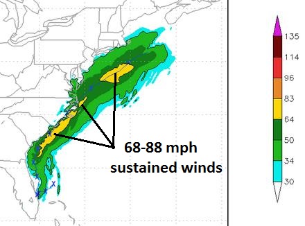
Projected Wind Swath.
NOAA's HWRF model is predicting strong tropical force to Category 1
hurricane force winds for the Carolina coast, with the strongest (80
mph+) winds remaining just offshore. Source: NOAA.
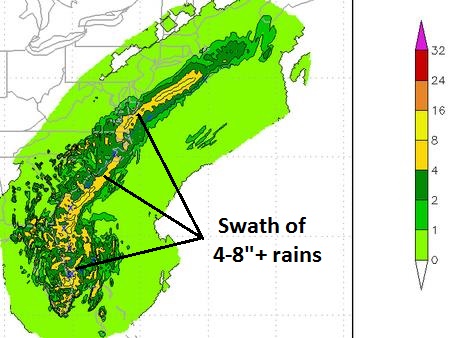
Heavy Rain-Maker, But Steady Motion Should Avoid Historic Rains.
A steady northeast track, accelerating as it passes the Outer Banks,
should keep most rainfall amounts in the 4-8" range, enough moisture for
inland river flooding and urban flooding of streets and poor drainage
areas, but the progressive nature of "Arthur" should prevent extreme
rainfall amounts. Map source: NOAA.
Resources for Emergency Managers:
NC Hurricane evac routes:
http://www.ncdot.gov/download/travel/travel_evac_hurricaneroutes.pdf
Storm Surge models:
http://www.wunderground.com/hurricane/GASCNCSurge.asp
Dare County evac route:
http://www.darenc.com/emgymgmt/huri3_map.asp
Currituck County evac route:
http://co.currituck.nc.us/pdf/Emergency-Management/map-evacuation-routes.pdf
Summary:
Every tropical system is different, unique. It may be similar to an
earlier system, but it's never identical. We examine a wide range of
models, but also rely on historical context before creating these
briefings. The forecast, sadly, is never black or white. The future is
always some nebulous shade of gray. That said,
the trend is for models to gradually ratchet up the intensity of this storm
- a good chance it will reach Category 1 hurricane status by Thursday
and Friday as it skirts the South Carolina coast and tracks over the
Outer Banks of North Carolina, where we expect storm surge flooding to
be most extensive and widespread. Facilities from Charleston to
Wilmington to Kitty Hawk, Corolla, Duck and Virginia Beach that have
flooded during previous tropical storms and (minimal) hurricanes should
experience flooding this time around as well, and all precautions should
be taken soon, rather than later, to be prepared for this storm system.
A few factors leave me extra-nervous: 1). This is the first storm of
2014 and there's a fair amount of complacency after a very quiet 2013
season, and 2). the fact that this potential hurricane is falling on the
4th of July holiday weekend, when local populations increase by 10-20X,
making for more traffic, more potential evacuation problems getting
people off the most vulnerable barrier islands. Leave (far) more time
than usual to get staff to safety, in the event Arthur does in fact
become a hurricane and impact the Carolinas.
The Confidence Level
that this storm will become a strong tropical storm or Category 1
hurricane has risen from a 2 Friday to 3 Saturday, now reaching a 6 on a
scale from 1 to 10. Bottom line: the probability of wind, water and
wave-related problems, especially for the Carolinas, continues to rise
over time.
We'll continue to track this developing storm and have updates on Tuesday.
Paul Douglas - Senior Meteorologist - Alerts Broadcaster
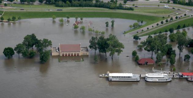
Most Extensive Closure of Mississippi Barge Traffic Since 2008. Details from Reuters and
The Chicago Tribune: "
Rising
flood waters were expected to make 11 locks and dams impassable on the
upper Mississippi River, forcing the closure of the river later on
Monday from Bellevue, Iowa, to Saverton, Missouri, the U.S. Army Corps
of Engineers said..."
Friday, June 27, 2014 file photo: "
Harriet Island was partial underwater near the Mississippi River." Kyndell Harkness - Star Tribune.
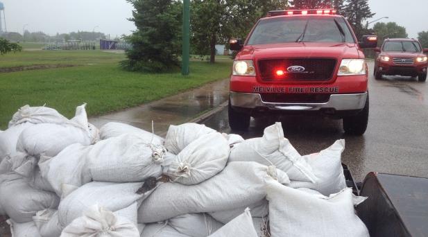
Saskatchewan Flooding: 16 Areas Declaring State of Emergency. A perptually stalled jet stream is also causing problems just to our north and west. Here's a clip from Canada's
CBC: "
Up
to 16 Saskatchewan communities have declared a state of emergency.
Eight highways, most located near the Man. border have been closed.
Heavy rainfall over the weekend in southeast Saskatchewan has some
communities struggling to keep up with the influx of water. It's led to
dangerous travel conditions after some highways were submerged or washed
out, and several states of emergency were declared..."
Photo credit above: "
All of the Melville's fire trucks are out helping pump water and sandbag where necessary." (Bonnie Allen/CBC News).
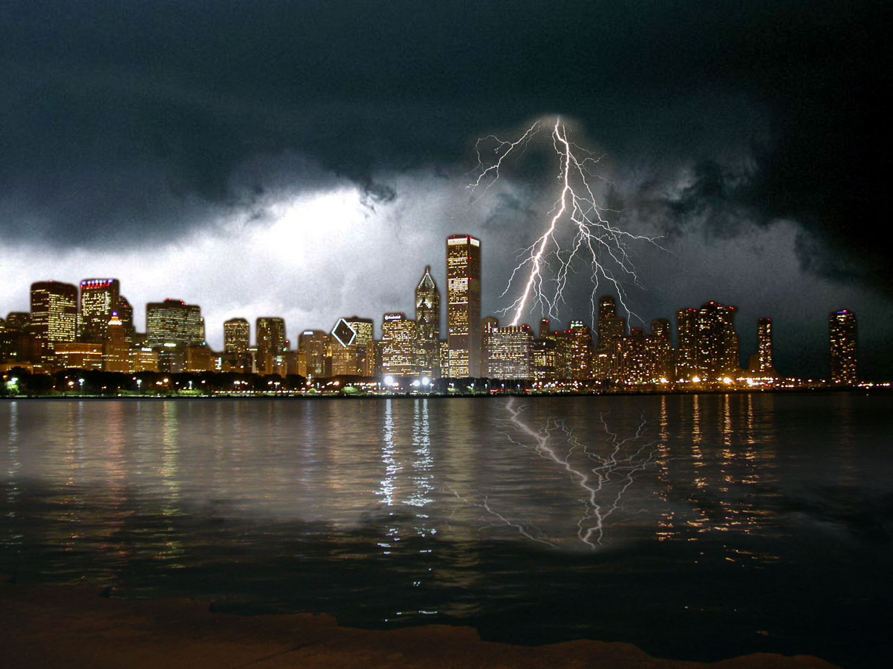 Chicago Area Faces $20 Billion Tornado Threat: Study.
 Here's an excerpt of an article at
CNBC that caught my eye, dispelling the myth that large tornadoes can't hit heavily populated metropolitan areas: "
If a tornado like the one that ravaged Moore, Oklahoma in 2013 struck the Chicago area, potential damage could exceed $20 billion, reinsurer Swiss Re
said on Monday..."Densely populated and developed Cook County, Illinois
has the greatest potential exposure to a violent and long track
tornado" compared to areas like Dallas and St. Louis, Swiss Re added,
with more than 112,000 people living in the damage zone of a Moore-like
tornado..."
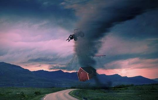
The Phenomenon Behind Tornadoes.
Gizmodo India has a good overview of the ingredients that go into tornado-producing thunderstorms; here's an excerpt: "...
Since
instability in the atmosphere as well as wind shear are necessary for
tornado formation, sometimes weak tornadoes can occur when the wind
shear conditions are strong, but the atmosphere is not very unstable.
This is known to have happened sometimes in the US state of California
in winter, when a strong low pressure system comes ashore. Similarly,
weak tornadoes can occur when the atmosphere is very unstable, but there
is little wind shear. For instance, Florida (which reports more
tornadoes than any other state in the US) has many weaker tornadoes of
this type. Naturally, the most violent of tornadoes occur when both
strong instability and strong wind shear are combined and present. This
occurs in the middle part of the country mostly during the spring and to
a lesser extent during fall..."
Enormous Tornado-Blocking Walls: Could Wild Idea Really Work?
The short answer is no. But this keeps making the rounds (kind of like a
meteorological Bigfoot) so here's a link to the concept and why it
probably can't work, courtesy of
Live Science: "
Tornadoes
are as much of a given in the Midwest as cornfields and county fairs.
In an average year, twisters kill 80 people and injure more than 1,500,
so you can imagine the excitement when a physics professor proposed an
end to the annual misery: three great walls, each about 1,000 feet (300
meters) tall, that could potentially block the deadly storms of Tornado
Alley. But the idea didn't impress meteorological scientists. Never mind
the huge cost, ecological consequences and engineering difficulties
involved in the scheme, weather experts say it just wouldn't work..."
Night Vision: China Enlists Drones In Fight Against Pollution.
And here I was worried about Facebook or the NSA spying on me - it's
really the drone circling overhead with a real-time HD camera I should
be concerned with.
The Wall Street Journal has the story - here's an excerpt: "
Watch
out, big Chinese polluters: The cover of night won’t help you anymore.
So say Chinese officials who are deploying aerial drones equipped with
infrared cameras to spot pollution emissions after the sun sets. The
Ministry of Environmental Protection said
Saturday that 11 unmanned aerial vehicles were used this month to
inspect 254 factories in the provincial-level regions of Hebei, Shanxi
and Inner Mongolia..."
Photo credit above: "
A traffic policeman signaling to drivers during a smoggy day in Harbin, Heilongjiang province." Reuters.
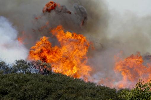
Feds Ask: Are Drones The Future of Firefighting? Here's another story that caught my eye, courtesy of the Twin Falls, Idaho Times News and
firehouse.com: "
When
it comes to analyzing dangerous wildfires, could a sensor attached to a
drone ever replace a human eye connected to an intellect shaped by
experience and intuition? That's one of the many questions federal
wildland firefighting officials are asking as drones become increasingly
popular in warfare and commerce. The wildfire drone conversation comes
on the heels of a national reminder about the human cost of firefighting
after one of the deadliest seasons in recent memory. Nineteen
firefighters died a year ago Monday at the Yarnell Hill Fire in Arizona.
In all last year, 38 firefighters were killed in the line of duty as
fire burned 4.1 million acres and more than 1,000 homes..." (File photo: Nick Ut, AP).
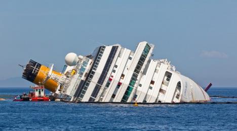
Air Bags Could Keep Sinking Ships Afloat. Just make sure they're BIG air bags. Here's an excerpt from a story at
Gizmag: "
The
European Union has invested in a project designed to keep damaged ships
stable and afloat by means of airbag-like balloons. It is hoped that
the new system, developed under the Su Sy project, will give emergency
services extra time to evacuate stricken ships, minimizing the
devastating losses of life synonymous with the sinking of cruise ships
such as the Costa Concordia, and the South Korean ferry Sewol, which
sank earlier this year..."
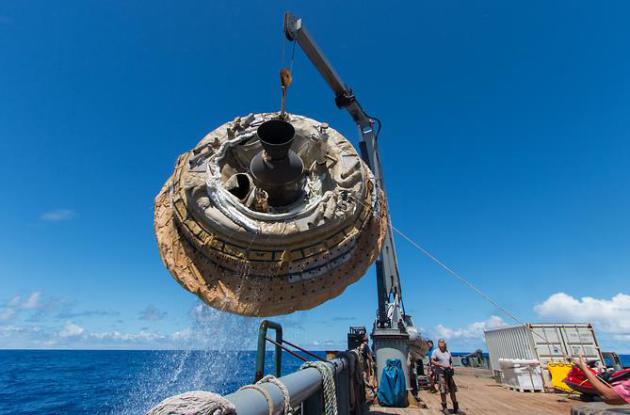
First LDSD Test Flight a Success. Flying saucer? Yes, but it's one of our ours. Here's an excerpt from
NASA: "...
This
test was the first of three planned for the LDSD project, developed to
evaluate new landing technologies for future Mars missions. While this
initial test was designed to determine the flying ability of the
vehicle, it also deployed two new landing technologies as a bonus. Those
landing technologies will be officially tested in the next two flights,
involving clones of the saucer-shaped vehicle..."
Photo credit above: "
Hours
after the June 28, 2014, test of NASA's Low-Density Supersonic
Decelerator over the U.S. Navy's Pacific Missile Range, the
saucer-shaped test vehicle is lifted aboard the Kahana recovery vessel." Image Credit: NASA/JPL-Caltech.
Pentagon: 7 in 10 Youths Would Fail To Qualify For Military Service. Here's an excerpt from
Time Magazine: "
The
quality of people willing to serve has been declining rapidly," the
U.S. Army Recruiting Command's commanding general says. Approximately
71% of the 34 million 17-to-24-year-olds in the U.S. would not qualify
for military service because of reasons related to health, physical
appearance and educational background, according to the Pentagon..."
Alcohol Responsible for 1 in 10 U.S. Deaths.
The PBS Newshour has the article; here's the introduction: "
Alcohol consumption was the cause of nearly one in 10 deaths among U.S. adults from 2006 to 2010, according to a recent report by the Centers for Disease Control and Prevention.
These numbers confirm that alcohol continues to be a leading cause of
premature death across the nation. The CDC found that over half of all
alcohol-related deaths were due to excessive consumption, or
binge-drinking. The majority, 69 percent, of these deaths occurred among
adults between the ages of 20 and 64..."
After Supreme Court Ruling, Aereo's Rivals In TV Streaming Seize Opening. Still interested in cutting the cord?
The New York Times has an interesting article with a few more viable options; here's a clip: ".
..Television
is a castle filled with money,” said Rishad Tobaccowala, chief strategy
and innovation officer at Vivaki, the Publicis Groupe’s digital
marketing unit. “People are trying to get into that castle and take some
money.”....Eager for a piece of the $167 billion American television
market, dozens of companies are offering options for the growing number
of viewers known as cord cutters, who are canceling their traditional
pay-television subscriptions..."
The 10 Most Common Sunscreen Slip-Ups. I had no idea - if you're slathering on the goop and still getting fried there may be a reason; here's an excerpt from
The Huffington Post: "...
If you've been slathering on the SPF but still come home from a day in the sun looking like a lobster, check your medicine cabinet. Common
over the counter medications like ibuprofen, Aleve, Motrin and Advil
decrease the efficacy of sunscreen. Other culprits include Benadryl and
other antihistamines, antibiotics such as Tetracycline and doxycycline
and many acne treatments containing benzoyl peroxide..."
TODAY: Mostly cloudy, cool and showery. Winds: W 10-20. High: 67
TUESDAY NIGHT: Evening showers, partial clearing late. Low: 53
WEDNESDAY: Better: becoming partly sunny, less wind. High: 72
THURSDAY: Best day in sight. Sunny and perfect. Wake-up: 55. High: 78
4th of JULY: Sunny start, late-day T-storm risk. Wake-up: 57. High: near 80
SATURDAY: Sticky sun, late night T-storms? Wake-up: 64. High: 83
SUNDAY: Hot sun, very humid with spotty T-storms. Dew point: 72. Wake-up: 69. High: 88
MONDAY: More numerous T-storms, muggy and unsettled. Wake-up: 72. High: 84
Climate Stories...
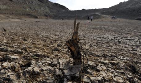
Global Warming Makes Drought Come On Earlier, Faster and Harder. University of St. Thomas engineer and climate scientist John Abraham has the story at
The Guardian; here's a clip: "...
Droughts,
one of the most intensely studied climate events, are a perfect example
of an effect with both human and natural influences. Separating the
relative strengths of the influences is a challenge for scientists. But,
when we deal with drought, with its large social and economic costs, it
is a challenge we must undertake. A very recent study tries to do just this. Published in the Journal of Climate, authors Richard Seager and Martin Hoerling
cleverly used climate models forced by sea surface temperatures to
separate how much of the past century’s North American droughts have
been caused by ocean temperatures, natural variability, and humans..."
Photo credit above: "
Yemenis
walk through a drought-affected dam on the outskirts of Sana'a, Yemen.
Sana a city is running out of water and many relief agencies feel that
it could become the first capital city in the world to run out of a
viable water supply." Photograph: Yahya Arhab/EPA.
Former U.S. Treasury Secretary Rubin on Climate Change: "The Risk Here is Catastrophic". Here is a video and transcript from a
CNN interview on Fareed Zakaria's Sunday show on Sunday, in case you missed it: "...
Yeah.
I think the cost of inaction is quite high, because it's - it's actual
radical risk taking. There's a tendency for people to say let's wait
until we get more information. But the longer you wait, you get to a
dangerous point - a dangerous position, where the only things you can do
then is to adapt to these adverse consequences as opposed to being able
to prevent them. Because one of the things that I think is pretty
clear is that if we act soon, we can avoid the most adverse consequences..."
How High Would A Carbon Tax Really Have To Be To Reign In Climate Change? Public Radio International (PRI) has the story - here's a snippet: "...
Professors Nicholas Stern and Simon Dietz
contend that current models grossly underestimate the actual risks and
costs of global warming. If we want to have the market rein in carbon
pollution, say Stern and Dietz, we need to place a much higher price on
carbon pollution. The most widely-used economic model for calculating
the economic cost of climate change is based on the work of Yale
economist William Nordhaus. He called his model DICE — "Dynamic Integrated Climate Economy..."
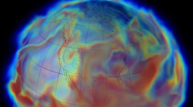
Image credit above: NASA. "
The
Modern Era Retrospective-analysis for Research and Applications (MERRA)
is producing a comprehensive record of Earth’s weather and climate from
1979, the beginning of the operational Earth observing satellite era,
up to the present."
Keep Nuclear Plants Open. Here's an excerpt of an Op-Ed at
The New York Times that caught my eye yesterday: "...
Nuclear
plants produce nearly a fifth of the United States’ total power
production, but in 2013 accounted for an overwhelming 63 percent of the
country’s carbon-free energy. Nuclear energy also prevented 589 million
metric tons of carbon dioxide emissions in 2013, equal to the carbon
emissions emitted by 113 million passenger cars — more than all
passenger cars in the country..." (Image: CNN).
Birthing The Solar Age.
Are we on the cusp of technological revolution and price drops that
will put renewable energy into the hands of everyone? Or is that
prediction wildly optimistic? Here's a story and video from Peter
Sinclair at
Climate Denial Crock of the Week: "...
For
months I’ve been gathering interviews with people I know who are
following the renewable energy explosion – and everywhere I go, I’m
telling people that we are in a stage very much like the internet in
about 1993 – taking shape and about to blow up. In fact, the key
enabling technologies for renewables are growing right out of the
distributed information network that is shaping the new century. There’s
no going back, and the companies, and countries, that do not grasp the
scale of the change we are seeing, may not survive..."


No comments:
Post a Comment