Maybe it's time to play the Lotto:
77 F. yesterday's high in the Twin Cities.
77 F. average high on June 10.
77 F. high on June 10, 2013
(No, I can't remember ever seeing this before, a perfect match. Maybe it's a good omen. Then again...)
June 10 in Minnesota Weather History. Source: Twin Cities NWS:
2001:
Severe weather over central Minnesota. An unofficial wind gust of 119
mph is reported at a seed farm 1 mile northwest of Atwater. A storm
chaser's car was battered when he got too close to the storm. Most of
the windows in the car were broken.
1996: 5.91 inches of rain fell at Mankato. Mudslides closed roads including Hwy. 169. Mud pushed a trailer home 20 feet down a hill.
1922: Hailstorm at Maple Plain causes much damage to crops.
Seasonal Lag
I
may be hallucinating (again) but it sure seems like our seasons are
being time-shifted, just like the TV shows you control with your DVR
remote control. Think about it. April felt like March, May was chilly
and April-like, now June is trending cooler & wetter, more typical
for May.
When does perception become reality?
Weather is
always erratic and chaotic, but Minnesota springs since 2011 have been
unusually wet - autumn warmth now lingers later in the season - winter
snow and ice often not building up until December.
A few years
does not a trend make, but once again the core of the jet stream, the
main superhighway for storms, is locked 300-500 miles farther south than
average. Unusually strong storms are spinning up along this sharp
thermal boundary, squeezing out very heavy amounts of rain.
Since
January 1 MSP has picked up nearly 18 inches of precipitation, second
only to 1965 for the wettest start to a year. By the way, NOAA's GFS
model prints out another 3 inches over the next 16 days, the ECMWF shows
2.7" of additional rain by next Wednesday. We may yet break that 1965
rainfall record.
T-storms are likely tonight and Saturday into
Sunday AM. The ECMWF hints at severe storms and flooding by the middle
of next week. Not a 90F in sight.
Forget the calendar. It's still May.
2.7" rain predicted by ECMWF over the next 10 days.
2.07" rain forecast for KMSP by the GFS model over the next 16 days.
Remarkably Persistent.
West of the Rockies the weather map looks like something out of July or
August, the weather consistently sunny, hot and dry (with a risk of a
brushfire). East of the Rockies much of America is in an almost May-like
pattern with an unusually strong jet stream positioned farther south
than usual for the second week of June. That, in turn, will spin up a
series of strong storms over the northern tier states, capable of flash
flooding and severe weather outbreaks. Showers and T-storms push from
the Mississippi Valley to the east coast by Thursday; showery rains
brushing the Pacific Northwest. NOAA NAM Future Radar: HAMweather.
84 Hour Rainfall Outlook.
12km NAM guidance shows the heaviest swath of rain over the Red River
Valley tonight into early Thursday, with some 2-3" amounts. Heavy rains
capable of flash flooding are possible west of Washington D.C. between
now and 1 AM Saturday; a 7" bullseye west of Little Rock. Map:
HAMweather.
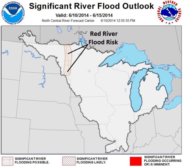
River Flooding Potential. The
North Central River Forecast
unit of NOAA is predicting an enhanced risk of flooding on the Red
River in the coming days, due to repeated storms capable of dropping
some 2-4"+ rainfall amounts.
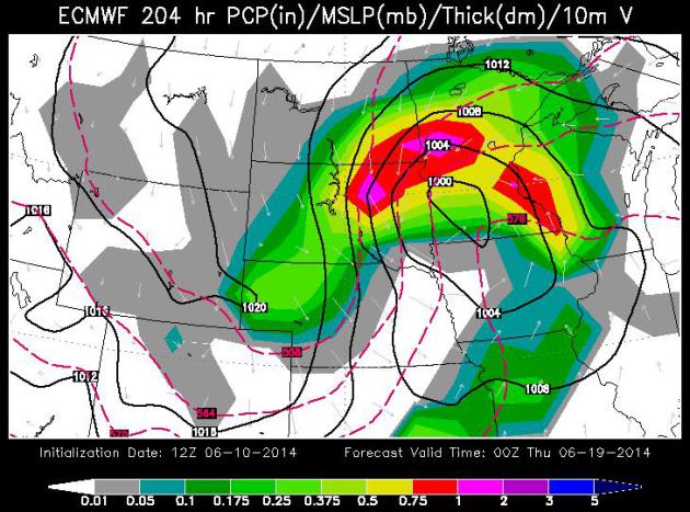
Way Out On A Soggy Limb.
I'm struck by how vigorous the storms are over the northern USA, a
pattern more typical of late April or early May. The jet stream is still
trending farther south than usual for the second week of June, and that
may spin up a significant storm by the middle of next week. In fact
ECWMF guidance valid next Wednesday evening hints at flooding rains and a
possible severe T-storm outbreak from the Dakotas and Minnesota into
Wisconsin. Map: WSI.
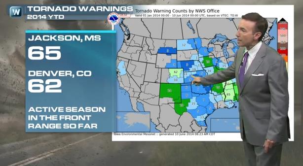
Unlikely Tornado Stats.
Which NWS office has issued the most tornado warnings so far this year?
Jackson, Mississippi (65), followed by Denver (62). Much of the central
and southern Plains, the heart of Tornado Alley, has been unusually
quiet. That may have something to do with the persistent drought of
recent months - little moisture available to fuel supercell
thunderstorms, especially in April and May, when tornado season peaks
from Wichita to Oklahoma City and Abilene. One silver lining to the
drought, which has eased a bit in recent weeks with torrential rain.
More details on today's edition of
Climate Matters: "
We
all have a natural fear of tornadoes and hurricanes, but when does it
cross the line to a phobia? WeatherNationTV Chief Meteorologist Paul
Douglas goes over lilapsophobia, the irrational fear of tornadoes and
hurricanes and explains why in the "Superbowl of Tornadoes" it's not so
crazy to have it."
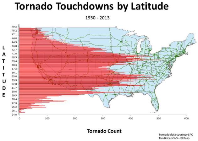
Map Shows U.S. Tornado Locations by Latitude, Longitude. Here's an excerpt of an interesting meteorological nugget, courtesy of
USA TODAY: "...
The
maps were created by Tim Brice, a meteorologist with the National
Weather Service in El Paso and were making the rounds on the weather
Twitterverse Monday. Brice used U.S. tornado data from 1950 to 2013 from
the Storm Prediction Center. The latitude that had the most tornadoes
was 39.8 degrees North, with 510 tornado hits, Brice says. The spikes in
tornadoes by latitude appear to correspond to the central and southern
Plains, with a "gap" due to the high mountains of the Appalachians..."
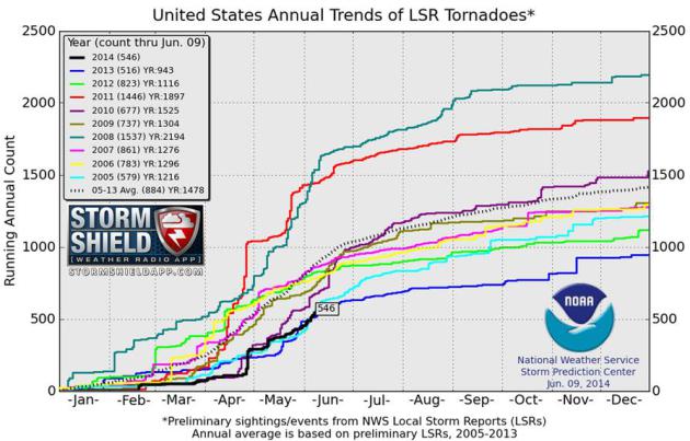
Annual Tornado Count Is Low - For Now.
Although the national tornado count, to date, is running lower than
average there's little room for complacency. Here's an excerpt of a good
update from
TheIndyChannel.com: "...
This
year, the U.S. has seen 546 tornado reports to date. In 2005, that
number was 579. Last year, it was 516. A week into June, the number is
right in the middle of 2005 and 2013. Looking at these two years closest
resembling this season, there are still two very different results.
Last year was one of the quietest tornado seasons on record, ending up
with 943 at the end of the year. But 2005 was closer to the average,
with a total of 1216..."
Hurricane Researchers Eye Low-Level Flights To Gauge Hurricane Strength. More of that military drone technology is trickling down to the rest of us. Here's a
Wall Street Journal story
excerpt explaining the importance of gathering real-time data in the
lowest few thousand feet of a hurricane, something only a drone can do:
"...
Hurricane researchers for years have deployed an array of
aircraft to help predict a storm's strength and path, form "Hurricane
Hunter" turboprops that flyin to its core to unmanned Global Hawks that
cruise high above it. But one of the most critical areas of a hurricane -
its lowest section, where the sea and winds churn violently - has
largely been off-limis because of the perils of sending manned aircraft
there. Now, scientists think they have a cost-effective solution: a
drone called the Coyote designed to venture into that turbulent zone for
as long as two hours and beam back a stream of data that paint a more
precise picture of a storm..."
Photo credit: Defense-Update.com, which has more information on the Coyote drone
here.
Flash Flood Warning vs. Flood Warning. What's The Difference?
There is lingering confusion over this terminology: flash flood
warnings are issued for extreme rains that trigger street and stream
flooding in a matter of minutes or hours - flood warnings usually imply
longer-term flooding on area rivers that may take days to unfold. Here's
an excerpt of a good explainer from
WBBJ-TV in western Tennessee: "..
Well
the biggest thing about a Flash Flood Warning is it can occur just very
quickly," Clements said. "A big downpour right there or just a massive
amount of water that would hit in a short amount of time. It could hit
any area." Clements says poor drainage or backups in sewers and ditches
are usually to blame. "Its just like traffic congestion. If you're
trying like everybody to leave a venue at one time, you just can't get
everybody out at once. It backs up." Clements said. A Flood Warning,
however, may not be issued until after the rain has stopped due to
continual runoff into our rivers and streams. A lot of that runoff can
be attributed to the large amount of construction over the area during
the past few years..."
92 Percent of Americans Have Survived a Natural Disaster, But Many Admit They May Not Be Prepared For The Next Big One. Here are some harrowing statistics in an article from
WSJ.com, PRNewswire and Allstate: "...
Despite
the frequency of severe weather, a new survey released by Allstate
shows people may not be as prepared as they should be for the next big
storm. Ninety-two percent of Americans surveyed have lived through a
disaster. Seven percent of the people polled say they or someone in
their family was injured when a disaster impacted their community. The
survey findings also revealed ...
* More than 90 percent of Americans have not practiced an evacuation plan or a way to escape if a major storm is approaching.
* 64% of Americans have not created an inventory list of the belongings in their home.
*
Nearly a third of Americans (30%) would take their chances and ignore
evacuation orders in the face of an imminent natural disaster...."
3 Ways Big Data, Supercomputing Change Weather Forecasting.
Accurate, industry-specific weather is critical, considering an
estimated 33% of the world's GDP is weather-sensitive. Here's an excerpt
of a story at
InformationWeek: "...
Unfortunately,
improving our ability to predict the weather is challenging, both
scientifically and computationally. Supercomputing has played a major
role in enabling predictive models since the 1950s and remains at the
cornerstone of today's weather and climate modeling. Constantly
improving computational capabilities have allowed scientists and
forecasters to produce results faster than ever while also investigating
increasingly complex phenomena and producing specialized forecast
products. From model performance to system and data management, weather
prediction presents unique high-performance computing challenges..."
Weather May Truly Affect Arthritis Pain.
Considering that water is the largest component in our bodies, small
but sudden changes in atmospheric pressure may have an effect, at least
on some people who suffer various aches and pains. Here's an excerpt of
an interesting Reuters Health story at
lifescript.com: "
For
people with osteoarthritis of the hip, pain levels tracked with the
weather over the course of a small two-year study, Dutch researchers
say. They looked at reported pain levels in a previous study of
arthritis, then went back to weather records to document the conditions
each day. It turns out the participants' aches were just a little worse
and joints just a little stiffer when humidity and barometric pressure
levels rose. "This is something that patients talk about all the time,"
Dr. Patience White told Reuters Health. A rheumatologist and vice
president for Public Health Policy and Advocacy for the Arthritis
Foundation, she was not involved in the study..."
Dont' Blame The Weather, Walmart: 4 Ways Perfectionists Tackle Problems.
Maybe it's human nature to blame the weather for problems (including
less profitability), but how often do you see executives thanking a
spell of good/quiet weather for great results? Here's a clip from a
story at
Forbes: "...
Chief
executives blame middling results on Mother Nature surprisingly often,
while good weather seldom gets credit for strong earnings. Research
shows that managers are susceptible to what psychologists call the
“fundamental attribution error”: Forces beyond our control get
disproportionate credit for negative results and much less mention when
performance is exemplary. One study of letters to shareholders
in annual reports found that executives attributed 60 percent of
favorable outcomes to internal causes, but only 27 percent of
unfavorable outcomes..."
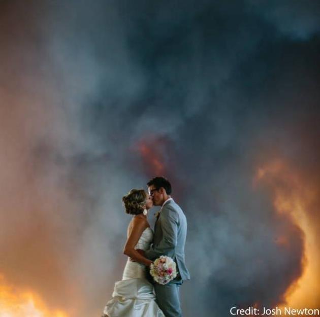
Wedding Photos Capture Approaching Wildfire.
Potentially dangerous? Absolutely, but this has to be one of the most
amazing wedding photos ever captured, anytime, anywhere. Here's a link
to more photos and the story at
FOX2now.com in St. Louis: "
An
Oregon couple nearly had to put their wedding on hold when a Bend
wildfire interrupted their ceremony. The bride, April Wolber, said the
Rock Springs Ranch just outside of Bend “just felt like the dream
location.” “It’s just kind of become our place,” she said. April Wolber
and her husband Michael were getting ready for the biggest day of their
lives. But as the ceremony start time neared, the Two Bulls wildfire was
growing nearby. Photographer Josh Newton captured these images of the fire approaching..."
Photo credit above: Josh Newton.
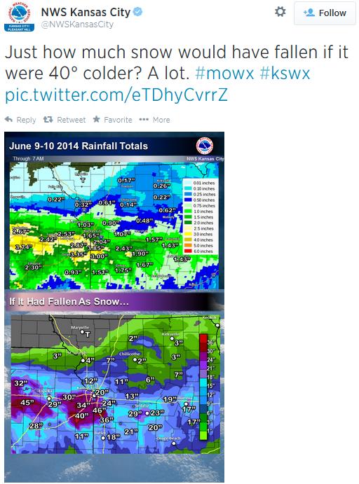
Interesting But Beside The Point. This tweet from the
Kansas City office
of the National Weather Service caught my eye. A straight conversion
from rain to snow yields some eye-popping numbers, as much as 40" of
snow. Keep in mind that cold air can't hold as much water vapor as warm,
tropical air, so the odds of this actually happening are very small -
unless a winter storm were to stall overhead for 3-4 days.
Hubble Captures The Most Comprehensive Image of the Universe Yet. This is pretty amazing; here's a clip of a longer story at
Gizmag: "
A
newly-released picture taken by the Hubble Telescope is adding more
color to the Hubble Ultra Deep Field (HUDF) image by detecting thousands
of galaxies in the ultraviolet spectrum. The study, called the
Ultraviolet Coverage of the Hubble Ultra Deep Field (UVUDF), directly
imaged stars and other celestial bodies that would have been impossible
to observe on the ground, and gives astronomers critical information
that will prove useful as the launch of the more powerful James Webb
Space Telescope approaches..."
Photo credit above: "
The
Hubble Space Telescope has taken a long-exposure picture of space in
the ultraviolet, revealing newly formed stars and galaxies." (Image: NASA/ESA)
Human Face Shaped By Millions of Years of Fighting, Study Finds. Here's an excerpt of an interesting story at
The Telegraph:
"Millions of years of fist fights have altered the human face to leave
men's jaws more robust than women's, a study has found. Evidence
suggests it evolved to minimise damage from bruising altercations after
our ancient ancestors learned how to throw a punch.."
Photo credit above: "
Evidence
suggests that men's jaws have evolved to minimise damage from bruising
altercations after our ancient ancestors learned how to throw a punch." Photo: Alamy.
Meet Shaheen and Waslawi, Your World Cup Predicting Camels. As good a way as any to pick winners, in my humble estimation. Details from
The Wire; here's a clip: "...
The
camels chose their winners by eating a pile of mushed up dates next to
the flag of their choosing. However, Al Jabri remains dubious about this
method, as well as the ability of camels to make such precious
predictions. “They are camels, not humans,” he told The National.
“Camels don’t understand football. It’s an animal, not a person.” Still,
no point the ruining what has now become as integral a part of the
World Cup as football songs and chants."
Ultimate Father's Day Gift: The Best Bacon of the Month Clubs. Because nothing says I Love You better than consistent shipments of bacon. Here's a clip from a story at
About.com: "
Bacon
is all the rage these days and it's hard to argue with its popularity.
Is there anything in the world more delicious than bacon? There's
chocolate covered bacon, bacon cupcakes, bacon candy, bacon-infused
vodkas... You name it, someone is probably making it. But what about
good old strips of bacon just fried up in a pan? The way it was meant to
be! Not that thinly sliced, flabby, chemical-filled junk they sell in
the supermarket, but hand-made, all natural artisan bacon made on the
farm or in the butcher shop. There's nothing better..."
TODAY: Warm sun, clouds increase late. Dew point: 57. Winds: SE 10-15. High: 81
WEDNESDAY NIGHT: A few showers, possible T-showers. Low: 57
THURSDAY: Showers north; turning windy & cooler. High: 66
FRIDAY: A cool, blue sky. Evacuate to cabin early. Wake-up: 53. High: 76
FRIDAY NIGHT: Dry and mild metro - thunderstorms push into far western MN. Low: 59
SATURDAY: Unsettled and more humid, heavy T-storms likely. High: 75
SUNDAY: T-storms taper, some PM sun. Wake-up: 63. High: near 80
MONDAY: Sunny start, more thunder late. Wake-up: 64. High: 80
TUESDAY: Muggy. Ripe for more T-storms. Wake-up: 65. High: 82
Climate Stories...
From Beer to Insurance: Businesses Bet on Climate Change.
At least the smart ones are already hedging their bets as they see the
symptoms of a more volatile climate system showing up in their bottom
line. Here's a clip from a story at
NBC News: "...
Some
big companies already are paying to counter weather-related damage.
More than 60 S&P 500 companies have spent money to offset climate
change, according to a report last month from the Carbon Disclosure
Project, which assesses companies and the environment. Gap, for example,
absorbed higher cotton costs after precipitation and drought changes in
China, according to the carbon project report. Floods in Thailand in
2011 hit local manufacturing, which affected Hewlett-Packard's revenues.
Dr. Pepper Snapple Group noted potential water supply and climate
changes could put $2.5 billion of its cost of sales at risk..."
Photo credit above: Jason Alden - OneRedEye via SABMiller.
Severe Weather Bigger Concern for Manufacturers Than Federal Emissions Rules That Could Raise Utility Bills, Report Says.
Does increasingly extreme weather, worldwide, pose a much larger cost
basis on manufacturers and supply chains than recent EPA mandates for
fossil fuel energy production?
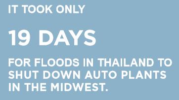
Columbus Business First has the story - here's a clip: "...
Business
Forward, a liberal business policy group, looked at the issue using
auto manufacturing – the nation’s largest manufacturing sector – as an
example. The conclusion? An increase in electricity prices still is
dwarfed by the cost of a severe weather event. The implication being
that while fewer carbon dioxide emissions, as called for by the U.S. Environmental Protection Agency,
may raise utility costs, reducing emissions mitigates climate change,
meaning weather may not be as crazy and weather-related work stoppages
for manufacturers might drop..."
* The report referenced in the article above is
here.
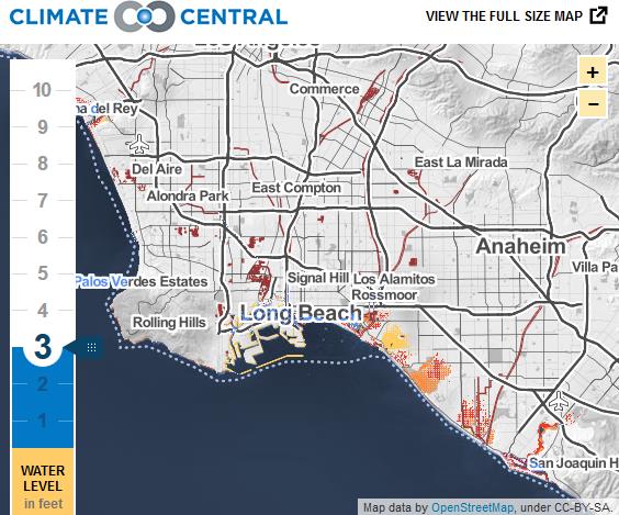
Global Warming's Flooding Could Hit L.A. Sooner Than Expected. Here's an excerpt of a story at The Informer at
laweekly.com: "...
Climate
Central has released new forecast data, including an interactive map
(below), on global warming's coastal effects for L.A. It found that ...
coastal flooding could affect 6,000 L.A. County residents, $1.4 billion
in property, 32 miles of public roads, and 34 sites listed by the U.S.
Environmental Protection Agency as potential sources of contamination.
If it weren't for protection "features" such as beach ridges and tidal
gates, the damage would be worse, Climate Central says..."
Climate Change Heats Up "Quants" vs. Old School Forecast Battle. Using historic (analog) weather data to predict the future? Good luck with that. Here's the intro to an interesting story at
Reuters: "
Computer
scientists are picking a new fight with old school meteorologists,
claiming finally to have cracked the code on weather forecasting at a
pivotal, profitable moment for the field, as climate change roils
commodities markets and industries. Banks and traders are reporting
outsized profits, and losses, on everything from natural gas to grains
as severe weather causes extra price volatility; power grid operators
are struggling with bouts of extreme cold or droughts that crimp
supplies while demand spikes; and more and more retailers and
manufacturers are using forecasts to manage inventories..."
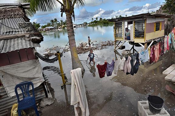
President Tong And His Disappearing Islands.
Climate change and rising seas is no longer a theory for the Pacific
island nation of Kiribati - it's an existential threat. Here's an
excerpt from
The New Yorker: "
Anote
Tong is the President of Kiribati, a country of some hundred thousand
citizens, which is disappearing under the sea. Kiribati (pronounced
keer-ree-bahss) is made up of thirty-two atolls and a raised coral
island that straddle the equator in the middle of the Pacific, and reach
barely six and a half feet above sea level. The country’s marine
territory surrounding the small islands, which total two hundred and
sixty-six square miles, is the size of India. When the tide is high, the
water closes in ominously on the shores..."
Photo credit above: Kadir van Lohuizen/NOOR.
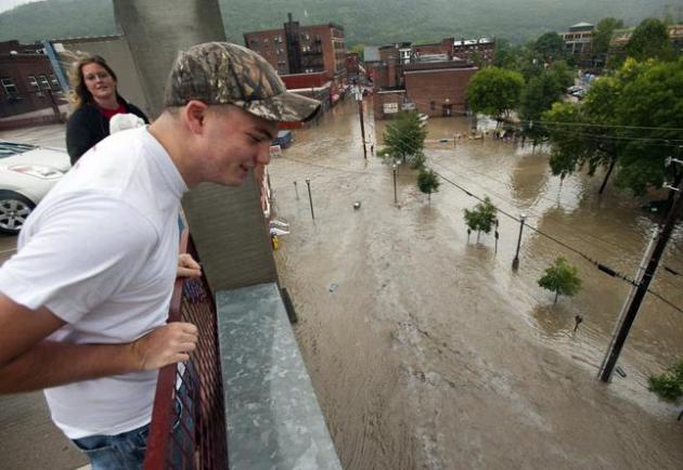
Vermont Climate Change Report Warns of Catastrophic Flood Risk. Here's an excerpt of a story at
The Chicago Tribune: "...
The
report, based on records from weather data to farmers' observations on
when ice thaws on ponds and plants bloom, found that average
temperatures in Vermont have risen by 1.3 degrees Fahrenheit (0.7 C) and
average annual rainfall has risen by 5.9 inches (15 cm) since 1960,
with almost half the growth coming since 1990. It projected that average
temperatures in the state would rise another 3 degrees Fahrenheit (1.7
C) by 2050, with the most pronounced changes in winter months and
overnight temperatures. One major risk posed by rising temperatures and
more intense rain storms is flooding similar to what the state
experienced in August 2011 when the remnants of Tropical Storm Irene
blew through, washing out 500 miles (800 km) of roads, cutting off towns
and destroying homes..."
File photo above: "
Derrick
Arbuckle watches from the top of a parking garage as the Whetstone
Brook floods downtown Brattleboro, Vt. on Sunday, Aug. 28, 2011. The
remnants of Hurricane Irene dumped torrential rains on Vermont on
Sunday, flooding rivers and closing roads from Massachusetts to the
Canadian border, putting parts of two towns underwater and leaving one
young woman swept away and feared drowned in the Deerfield River." (AP Photo/The Brattleboro Reformer, Chris Bertelsen).


No comments:
Post a Comment